| 1 | Murray Smelter Smoke Stacks | Murray, Salt Lake, Utah | | Murray Park
(Stacks were torn down in 2002) |
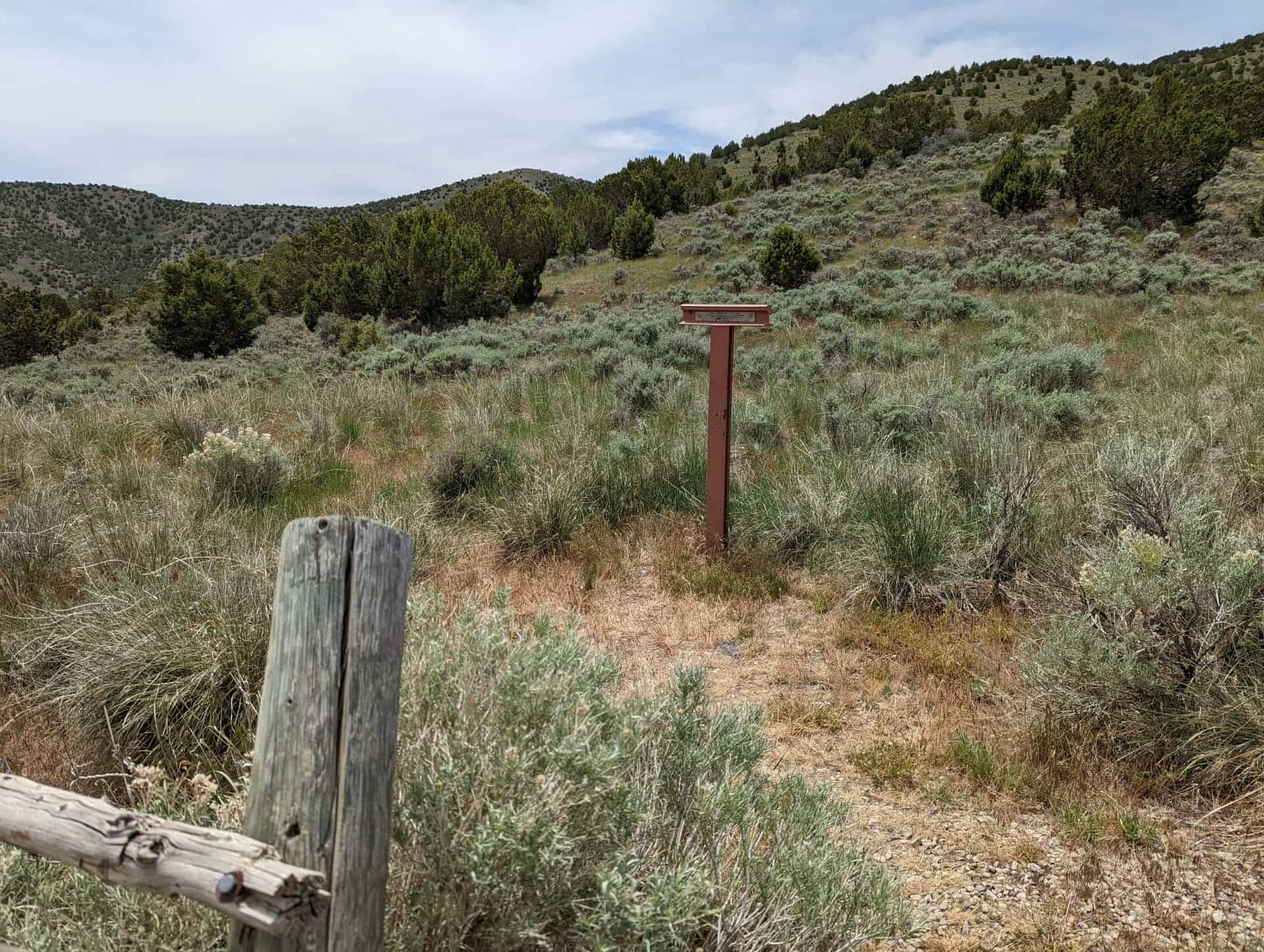
| 2 (Also UPTLA #86) | Lookout Station | Vernon, Tooele, Utah | Distant
Close up | N 40.11968 W 112.57649 |
| 3 (Also UPTLA #24) | Big Mountain | Little Emigration Canyon, Salt Lake, Utah | Distant
Close up | N 40.82793 W 111.65375 |
| 4 | The Golden Pass Road – Parley’s Canyon | Salt Lake City, Salt Lake, Utah | Distant
Close up | N 40.70859 W 111.80188 |
| 4-A | Early Pioneer Mills | Salt Lake City, Salt Lake, Utah | Distant
Close up | N 40.70859 W 111.80188 |
| 4-B | B&K Tannery | Salt Lake City, Salt Lake, Utah | Distant
Close up | N 40.70859 W 111.80188 |
| 4-C | Ensign Peak | Salt Lake City, Salt Lake, Utah | Distant
Close up | N 40.70857 W 111.80195 |
| 4-D | The Overland Stage | Salt Lake City, Salt Lake, Utah | Distant
Close up | N 40.70857 W 111.80195 |
| 4-E | Willard Richards | Salt Lake City, Salt Lake, Utah | Distant
Close up | N 40.70854 W 111.80200 |
| 4-F | Charles Stillman Bridge | Salt Lake City, Salt Lake, Utah | Distant
Close up | N 40.70858 W 111.80190 |
| 4-G | Handcart Companies | Salt Lake City, Salt Lake, Utah | Distant
Close up | N 40.70854 W 111.80200 |
| 4-H | Kanyon Creek Mill | Salt Lake City, Salt Lake, Utah | Distant
Close up | N 40.70854 W 111.80200 |
| 4-I | Brighton | Salt Lake City, Salt Lake, Utah | Distant
Close up | N 40.70854 W 111.80200 |
| 4-L | Horace A. Sorensen | Salt Lake City, Salt Lake, Utah | Distant
Close up | N 40.70849 W 111.80184 |
| 5 | Lorenzo Snow Burial Site | Brigham City, Box Elder, Utah | Distant
Close up | N 41.50262 W 112.00985
|
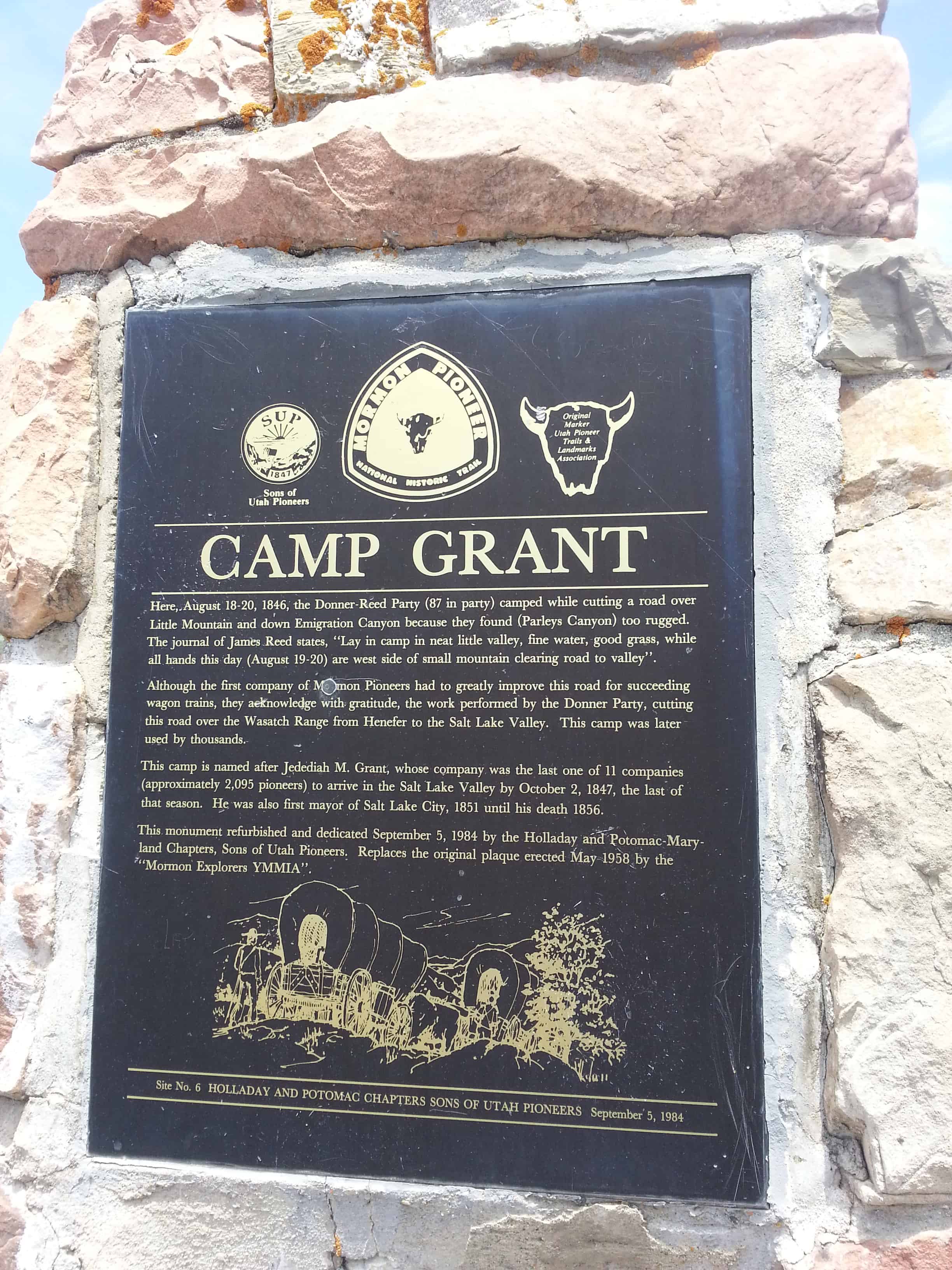
| 6 | Camp Grant | East Canyon, Salt Lake, Utah | Distant
Close up | N 40.76069 W 111.70866
|
| 7 | Early Riverton and the Magnificent Dome Church | Riverton, Salt Lake, Utah | Distant
Close up | N 40.51965 W 111.93351
|
| 8 | The Old Mill | Cedar City, Iron, Utah | Distant
Close up | N 37.67278 W 113.04384 |
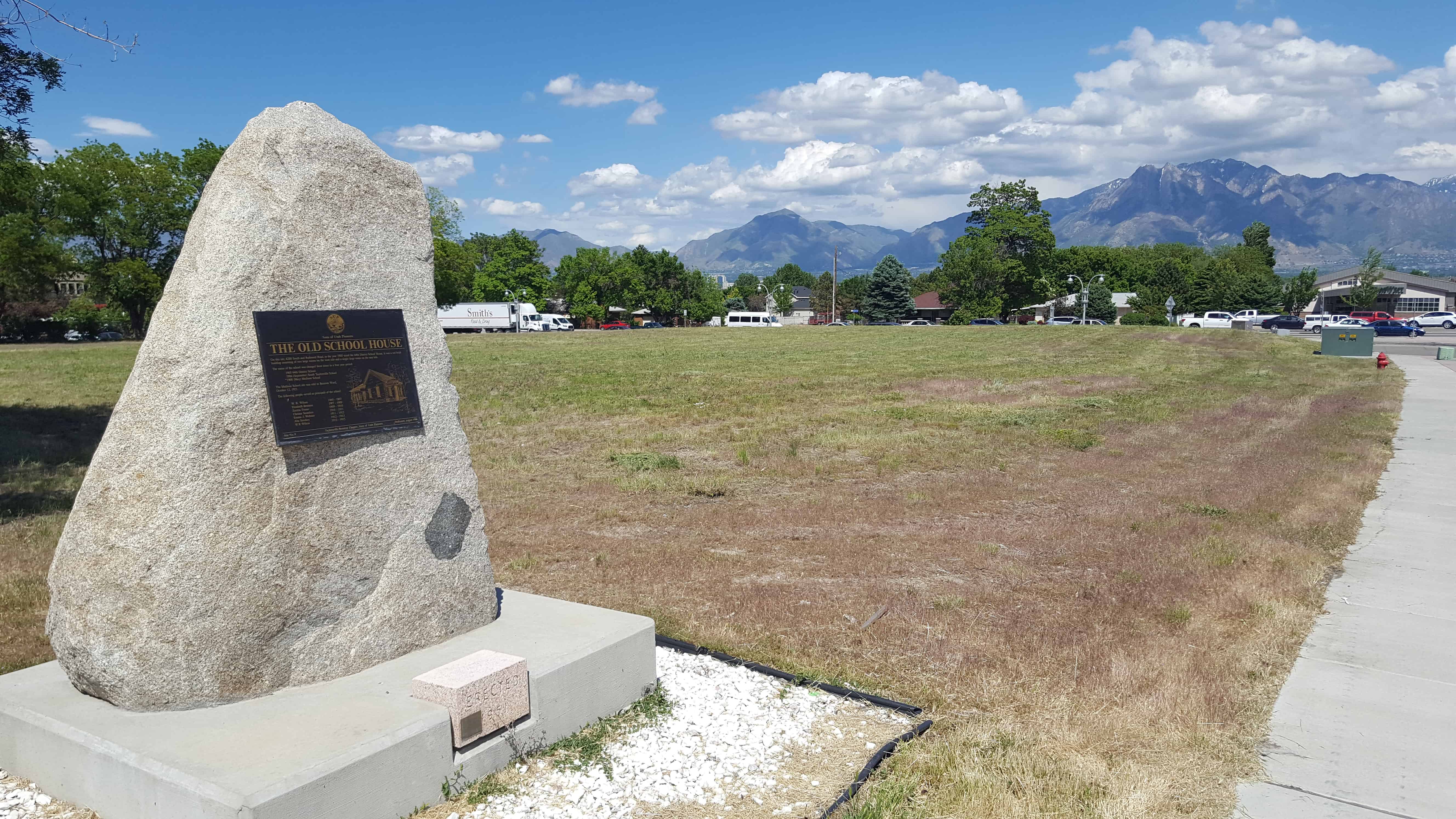
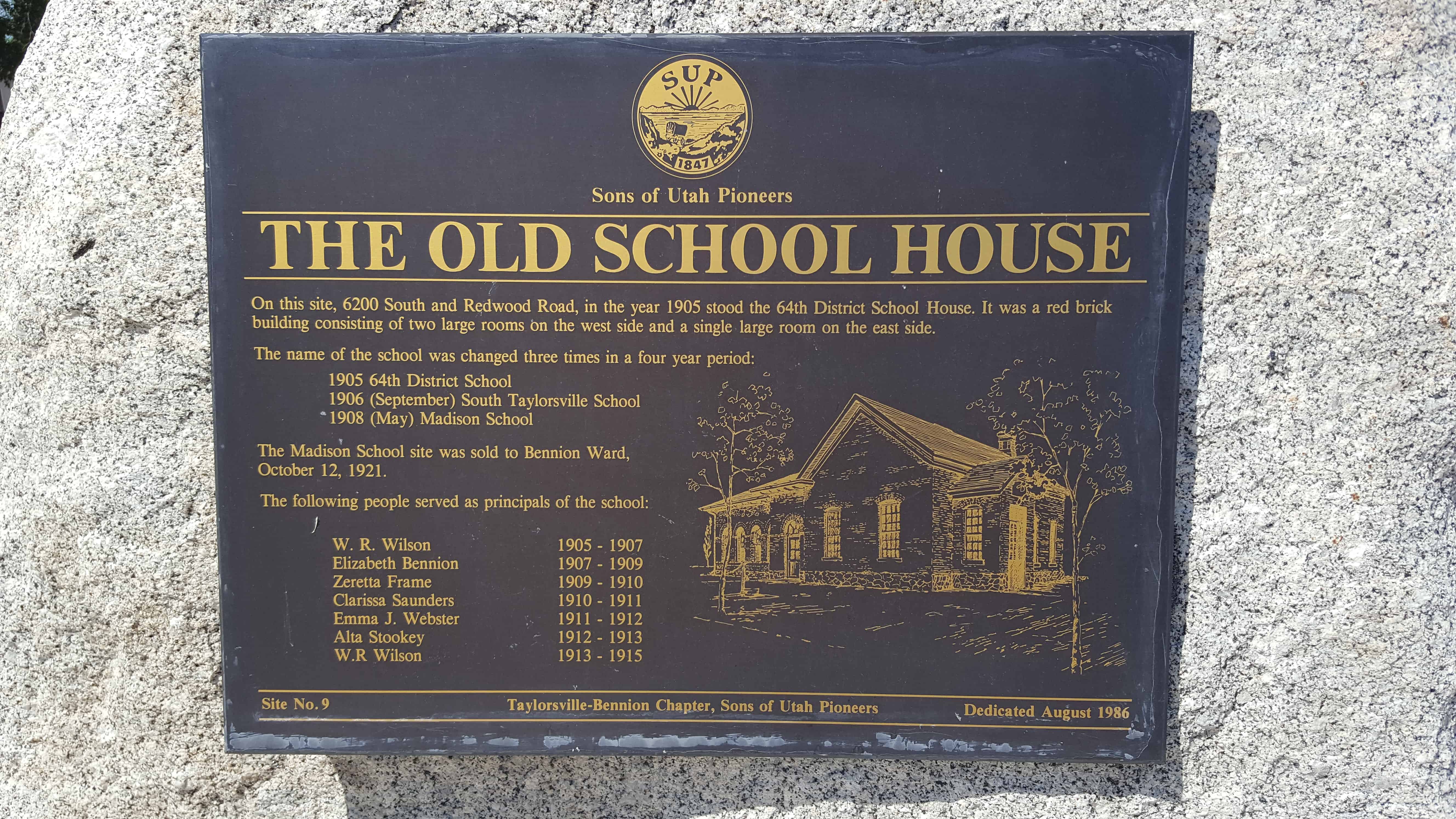
| 9 (Also #50) | The Old School House | Taylorsville, Salt Lake, Utah | Distant
Close up | N 40.63887 W 111.94008 |
| 10 | William Ajax Underground Store | Tooele, Tooele, Utah | Photo | |
| 11 | Early Sandy Schools & Church Takes Root in Sandy | Sandy, Salt Lake, Utah | Distant
Close up | N 40.59186 W 111.88227 |
| 12 | Utah Idaho Sugar Company Factory | Salt Lake City, Salt Lake, Utah | Distant
Close up | N 40.60694 W 111.94296 |
| 13 | Tribute to Taylorsville-Bennion Pioneers | Taylorsville, Salt Lake, Utah | Distant
Close up | N 40.66347 W 111.93015 |
| 14 | Early Arizona Pioneers | St. Johns, Apache, Arizona | | N 34.51448 W 109.37199 |
| 15 | Birth of Hurricane | Hurricane, Washington, Utah | Distant
Close up | N 37.17963 W 113.28264 |
| 16 | Legacy of the Black Pioneer | Salt Lake City, Salt Lake, Utah | Distant
Close up | N 40.69661 W 111.82717 |
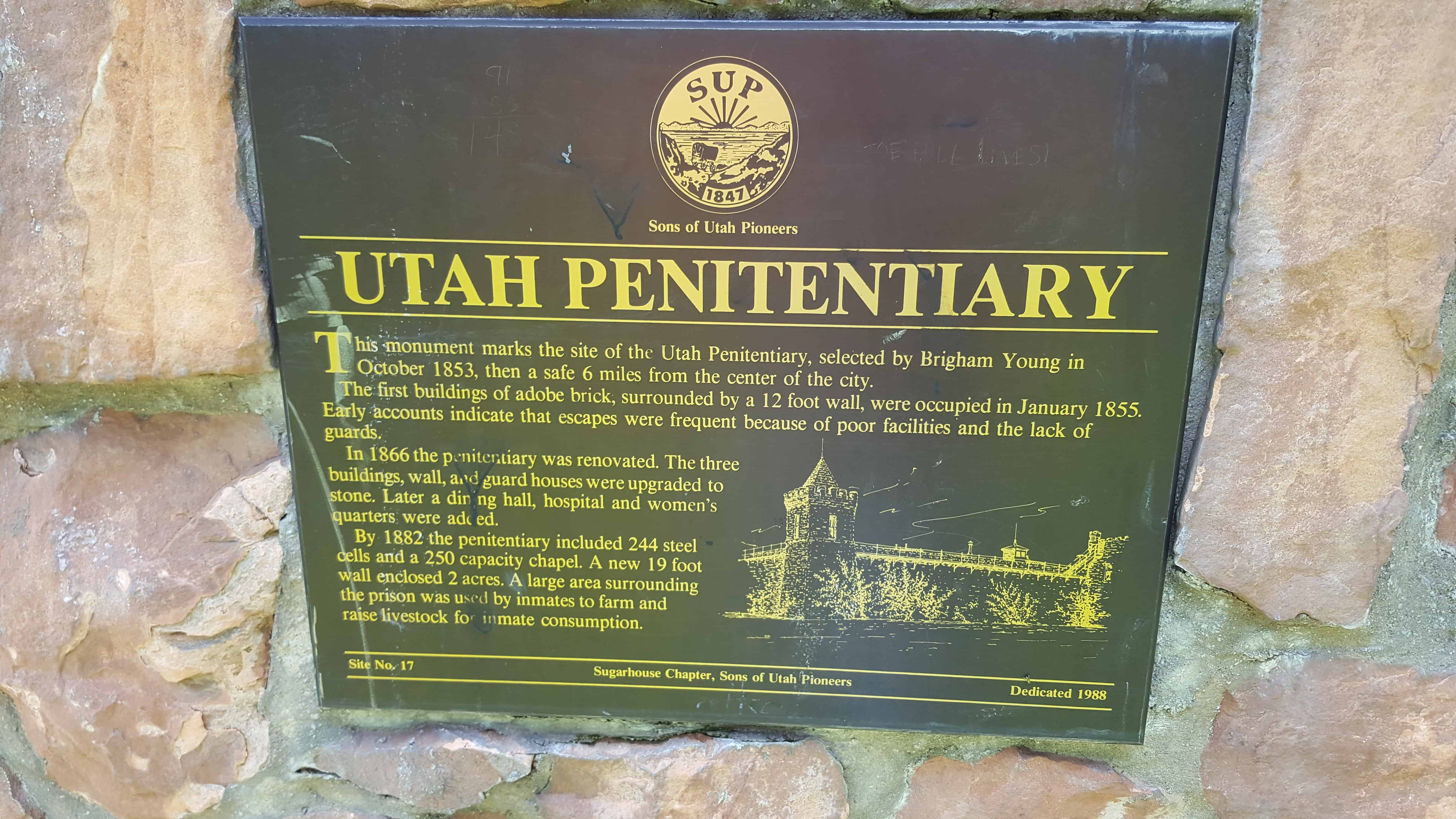
| 17 | Utah Penitentiary | Salt Lake City, Salt Lake, Utah | Distant
Close up | N 40.72505 W 111.84813 |
| 18 | Old Tabernacle Lintel Stone | Provo, Utah, Utah | Distant
Close up | N 40.23321 W 111.65971 |
| 19 | The Casting of the Lots | Cedar City, Iron, Utah | Distant
Close up | N 37.68523 W 113.14348 |
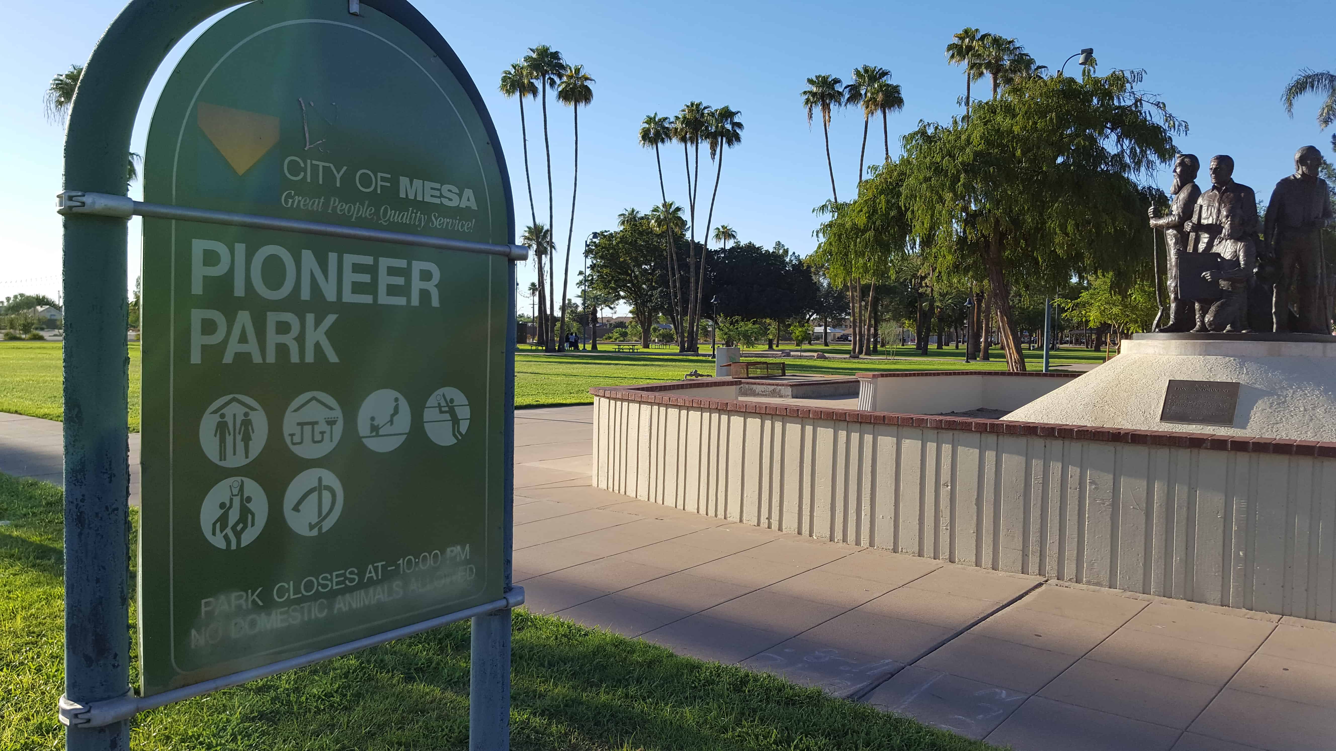
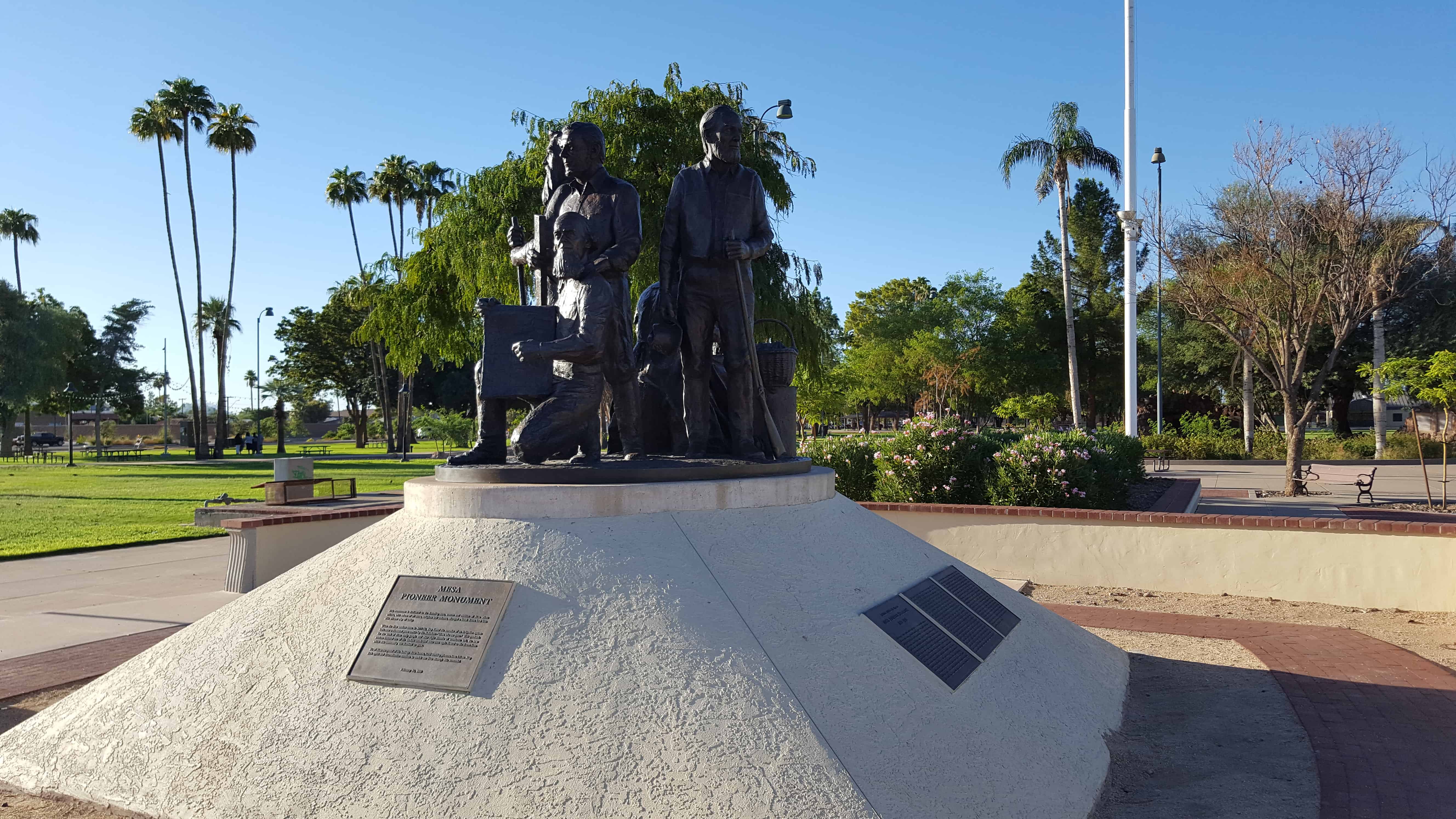
| 20 | Mesa Pioneer Monument | Mesa, Maricopa, Arizona | Distant
Close up | N 33.41528 W 111.81958 |
| 21 | Brigham City Tabernacle | Brigham City, Box Elder, Utah | Distant
Close up | N 41.50544 W 112.01516 |
| 23 | Hurricane Valley Pioneer Heritage Park | Hurricane, Washington, Utah | | N 37.17624 W 113.28852 |
| 23-A | Noble Pioneers of Hurricane | Hurricane, Washington, Utah | Distant
Close up | N 37.17624 W 113.28852 |
| 23-B | Early Public Buildings | Hurricane, Washington, Utah | Distant
Close up | N 37.17624 W 113.28852 |
| 23-C | Hurricane City | Hurricane, Washington, Utah | Distant
Close up | N 37.17624 W 113.28852 |
| 23-D | The Hurricane Canal | Hurricane, Washington, Utah | Distant
Close up | N 37.17624 W 113.28852 |
| 23.1 | Ensign Peak | Salt Lake City, Salt Lake, Utah | Distant
Close up | N 40.77666 W 111.89037 |
| 24 | Marriott Ward | Bountiful, Davis, Utah | | (Monument is retired) |
| 25 | Pioneer Care Center | Brigham City, Box Elder, Utah | Distant
Close up | N 41.49491 W 112.01902 |
| 26 | Half Way House | Sandy, Salt Lake, Utah | Distant
Close up | N 40.56331 W 111.89114 |
| 27 | Neff’s Station | Sandy, Salt Lake, Utah | Distant
Close up | N 40.56331 W 111.89114 |
| 28 | Early Magna Settlements | Magna, Salt Lake, Utah | Distant
Close up | N 40.68326 W 112.09141 |
| 29 | Emigration Canyon Railroad | Salt Lake City, Salt Lake, Utah | | (Hogle Zoo inside of the entrance) |
| 30 | The Idaho Falls LDS Hospital and School of Nursing | Idaho Falls, Bonneville, Idaho | | N 43.49726 W 112.04162 |
| 31 | Original Gristmill Stones | Bountiful, Davis, Utah | Distant
Close up | N 40.88024 W 111.87282 |
| 32 | Birthplace of Pioneer Pilot Russell L. Maughan | Logan, Cache, Utah | Distant
Close up | N 41.73143 W 111.83164 |
| 33 | South Cottonwood Campground | Murray, Salt Lake, Utah | Distant
Close up | N 40.64860 W 111.87033 |
| 34 | Mormon Lumber Road | Highway 18, San Bernardino, California | | N 34.23350 W 117.29381 |
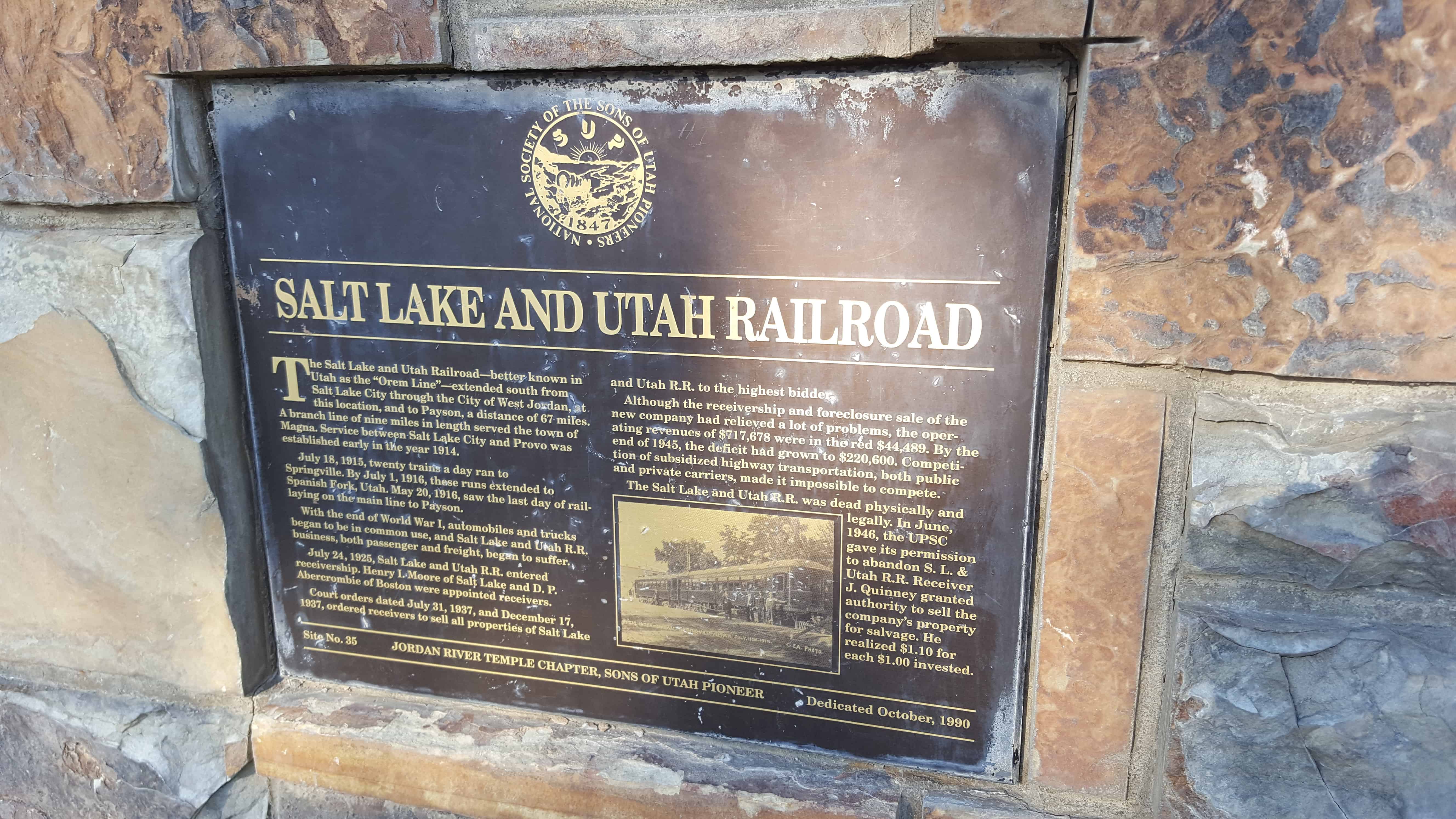
| 35 | Salt Lake and Utah Railroad | Salt Lake City, Salt Lake, Utah | Distant
Close up | N 40.60694 W 111.94296 |
| 36 (also UPTLA #38) | Mormon Station – Genoa | Genoa, Douglas, Nevada | | |
| 37 | Brigham Young Industrial Center | Salt Lake City, Salt Lake, Utah | Distant
Close up | N 40.71559 W 111.83420 |
| 38 | Ellen (Nellie) Purcell Unthank | Cedar City, Iron, Utah | Distant
Close up | 400 W. 200 S. |
| 39 | Jordan & Salt Lake City Canal | Sugarhouse, Salt Lake, Utah | Distant
Close up | N 40.72530 W 111.86017 |
| 40 | Palatkwapi Trail | Stoneman Lake, Coconino, Arizona | | N 34.78363 W 111.51845 |
| 41 | Old Chapel – Rest Stop | Murray, Salt Lake, Utah | Distant
Close up | N 40.64860 W 111.87021 |
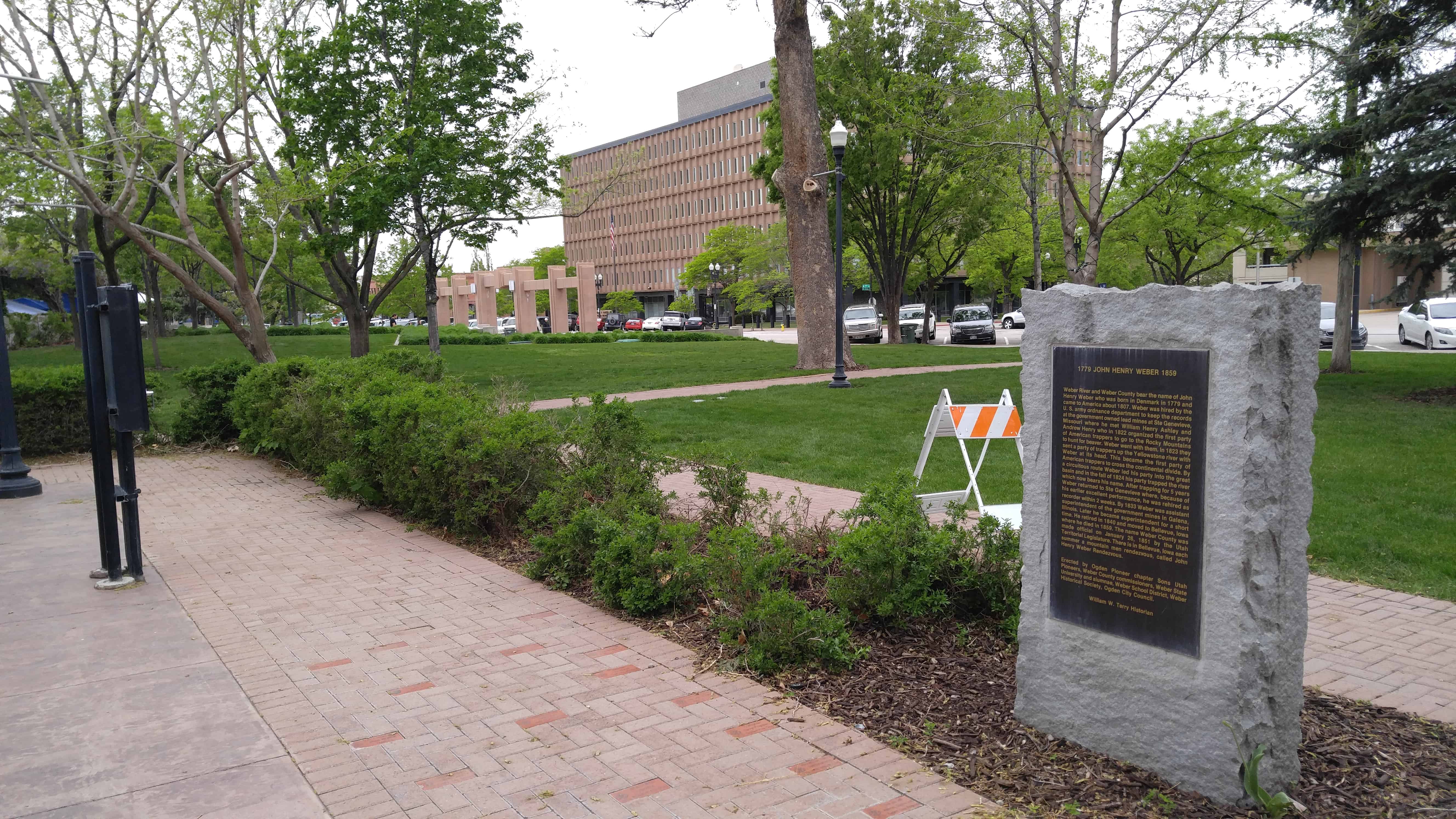
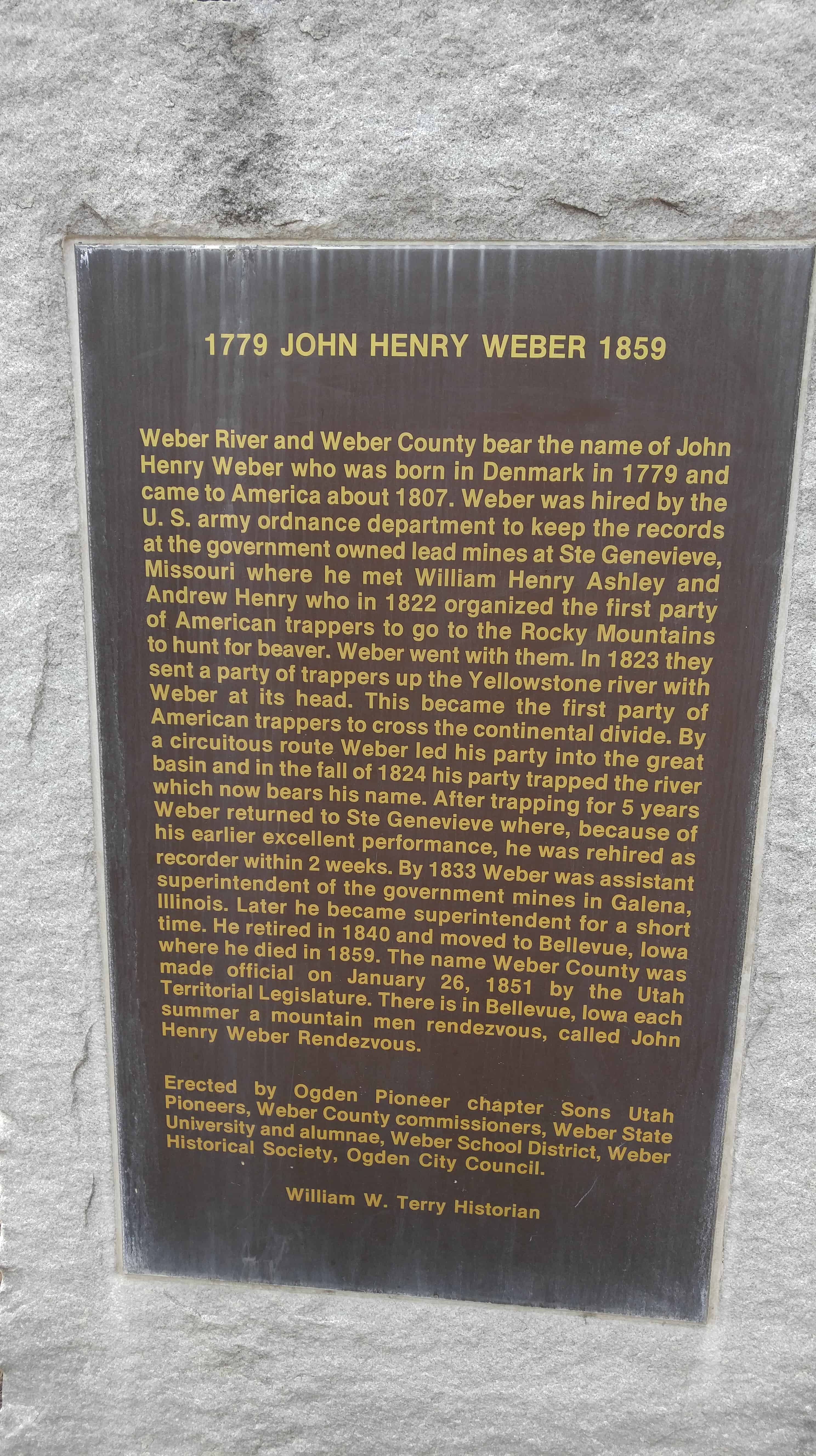
| 42 | John Henry Weber | Ogden, Weber, Utah | Distant
Close up | N 41.22028 W 111.97125 |
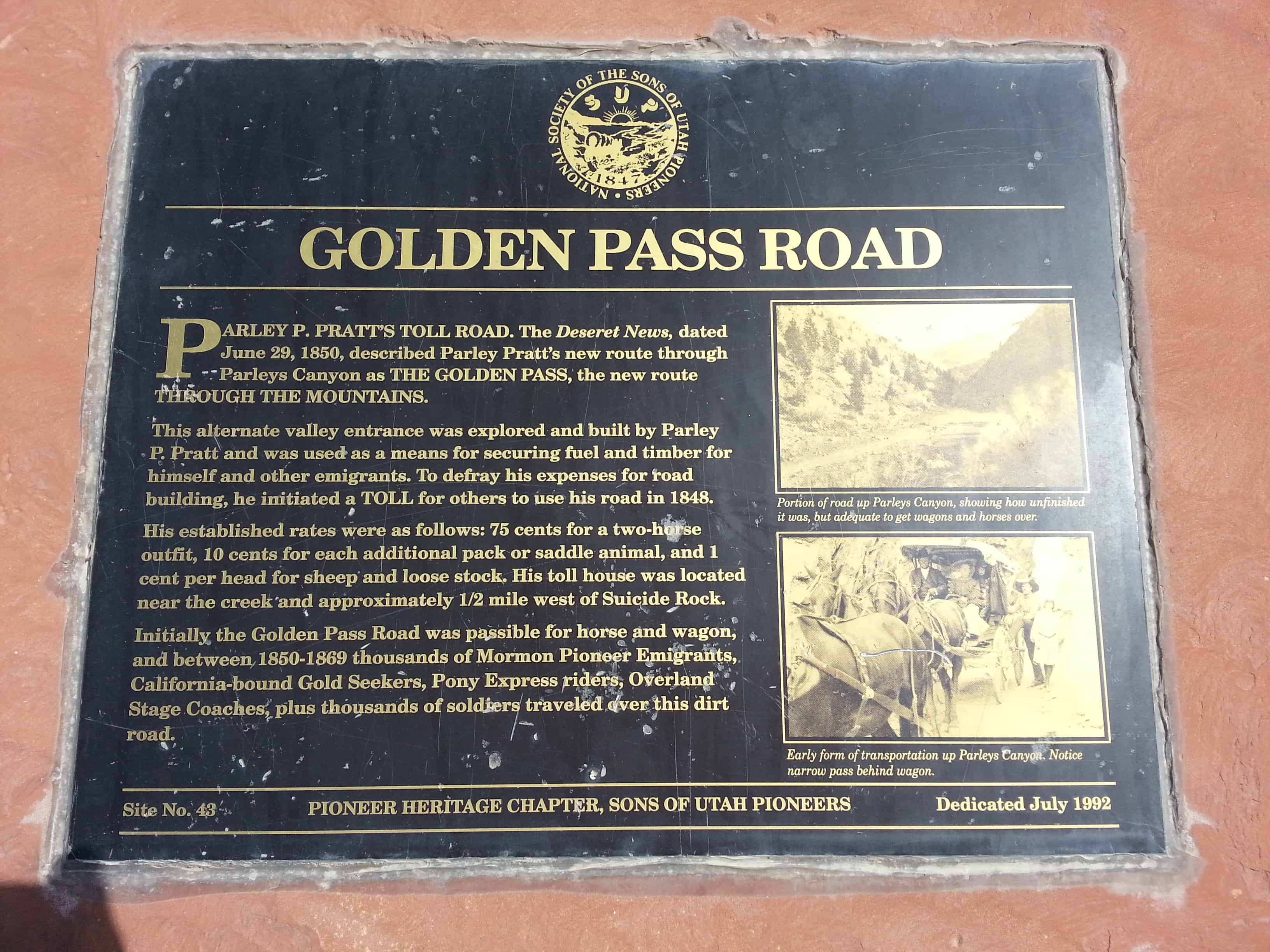
| 43 | Golden Pass Road | Salt Lake City, Salt Lake, Utah | Distant
Close up | N 40.71559 W 111.83420 |
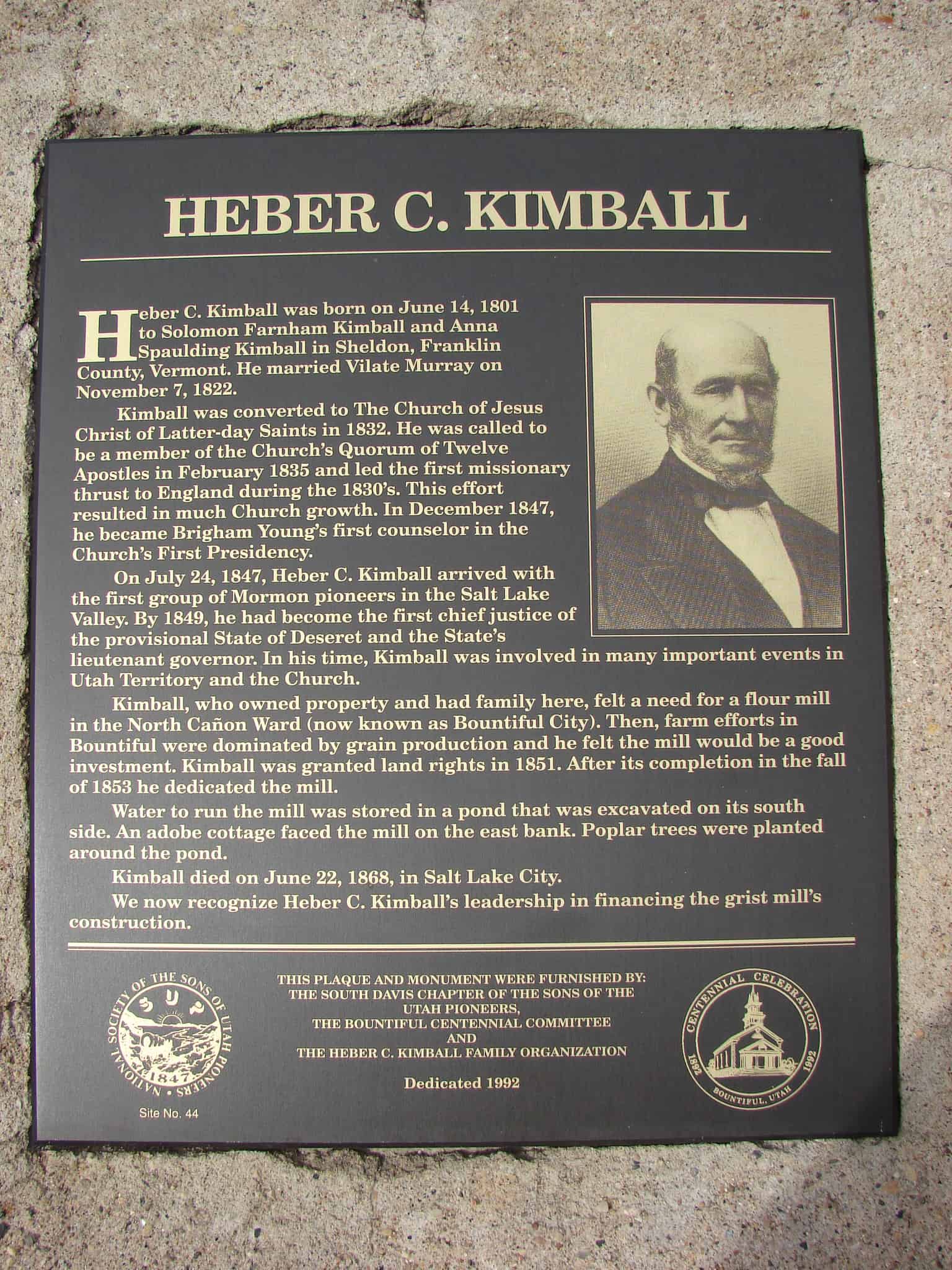
| 44 | Heber C. Kimball | Bountiful, Davis, Utah | Distant
Close up | N 40.88024 W 111.87282 |
| 45 | Daniel Davis | Bountiful, Davis, Utah | Distant
Close up | N 40.88024 W 111.87282 |
| 46 | George Quinn McNeil | Bountiful, Davis, Utah | Distant
Close up | N 40.88024 W 111.87282 |
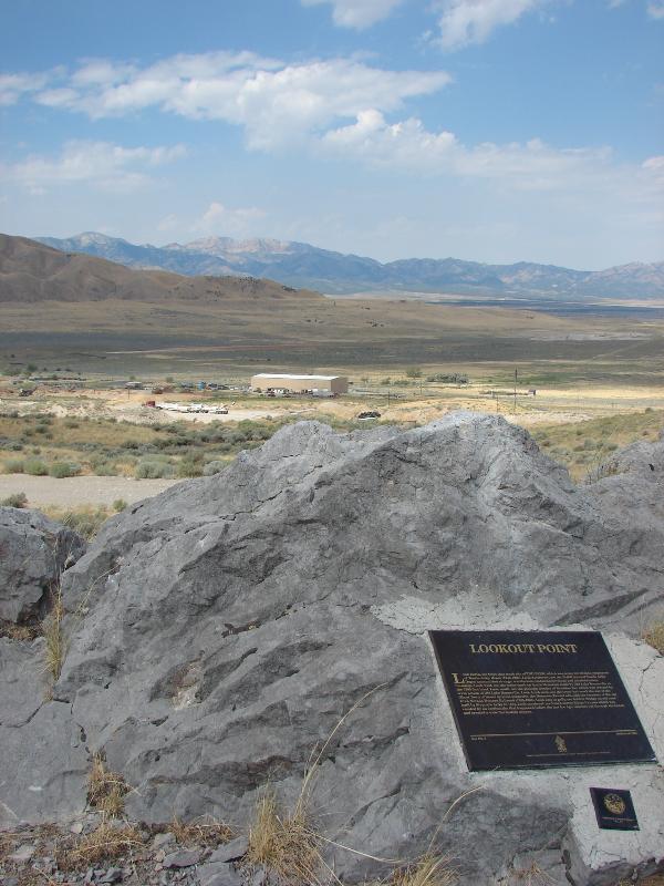
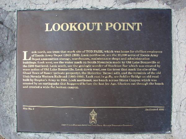
| 47 | Lookout Point | Tooele, Tooele, Utah | Distant
Close up | N 40.47705 W 112.34768 |
| 48 & 92 | Buffalo Park | Lake Point, Tooele, Utah | Distant
Close up | N 40.69233 W 112.26234 |
| 49 | Mormon Pioneers at Fort Laramie | Fort Laramie, Goshen, Wyoming | | N 42.21289 W 104.51665 |
| 50 & 9 | The Old School House | Taylorsville, Salt Lake, Utah | Distant
Close up | N 40.63887 W 111.94008 |
| 51 & 187 | Little Mountain Summit | Emigration Canyon, Salt Lake, Utah | Distant
Close up | N 40.77495 W 111.71830 |
| 52 | Mormon-Carson Pass Emigrant Trail | Carson Pass, Alpine, California | | N 38.64163 W 120.13632 |
| 53 | Anderson Tower | Salt Lake City, Salt Lake, Utah | Distant
Close up | N 40.77645 W 111.88378 |
| 54 | Old Brickyard Chimney | Salt Lake City, Salt Lake, Utah | Distant
Close up | N 40.70335 W 111.85985 |
| 55 | Box Elder Fort | Brigham City, Box Elder, Utah | Distant
Close up | N 41.51672 W 112.01863 |
| 56 | Johnson Canyon Cemetery | Kanab, Kane, Utah | | Thirteen miles east of Kanab |
| 57 | Harrisburg Residents | Harrisburg, Washington, Utah | Distant
Close up | N 37.20747 W 113.39275 |
| 58 | Dan Jones, Welch Missionary | Provo, Utah, Utah | | Painting at the MTC |
| 59 | Genoa First Cabin | Genoa, Douglas, Nevada | | |
| 60 | Cedar Fort Marker, (formerly listed as Iron Mines) | Cedar City, Iron, Utah | Distant
Close up | N 37.68830 W 113.07972 |
| 61 & 62 | Taylorsville–Bennion Cemetery & Cemetery Flagpole | Taylorsville, Salt Lake, Utah | Distant
Close up | N 40.67081 W 111.93786 |
| 63 | Temple Fork Sawmill | Logan Canyon, Cache, Utah | | N 41.83541 W 111.59341 |
| 64 | Lambs Canyon | Salt Lake City, Salt Lake, Utah | Distant
Close up | N 40.70859 W 111.80188 |
| 65 | First Settlers of Holladay | Holladay, Salt Lake, Utah | Distant
Close up | N 40.66563 W 111.82157 |
| 66 | Memorial to Centerville Pioneers | Centerville, Davis, Utah | Distant
Close up | N 40.92033 W 111.87872 |
| 67 | Little Emigration Canyon | Little Emigration Canyon, Morgan, Utah | Distant
Close up | N 40.81552 W 111.58490 |
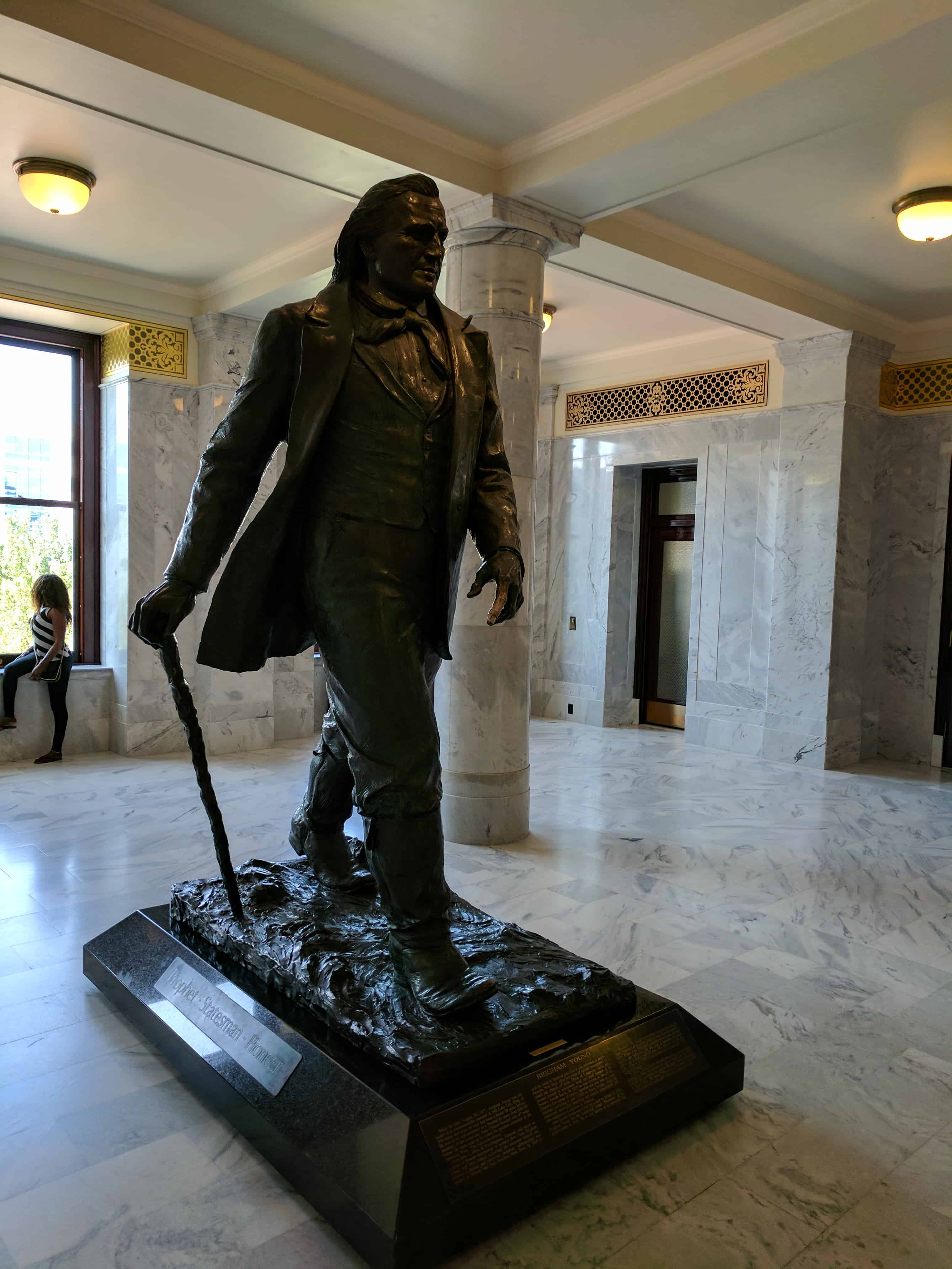
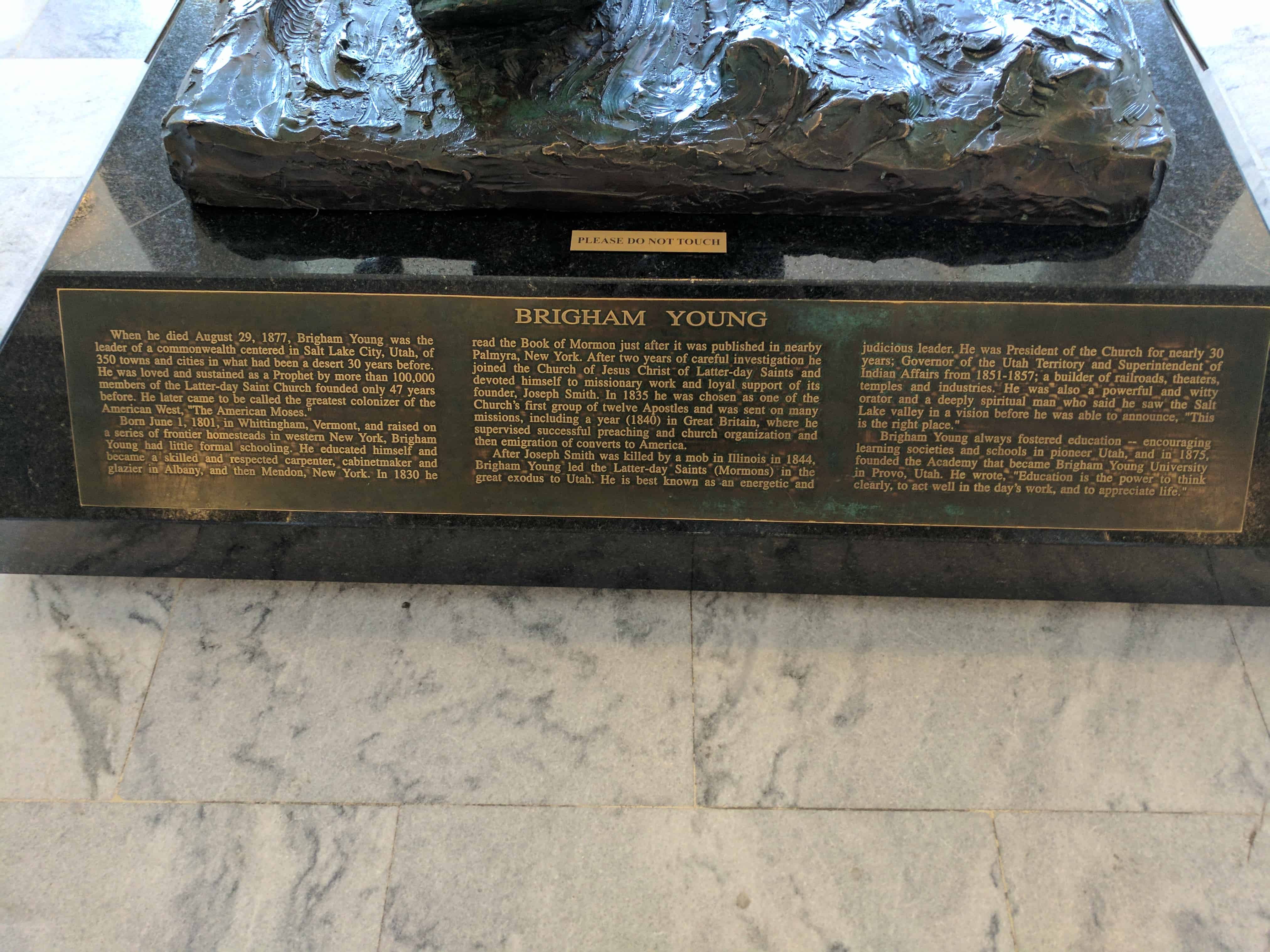
| 68 | Brigham Young Statue | Salt Lake City, Salt Lake, Utah | Distant
Close up | N 40.77772 W 111.88821 |
| 69 | Hilda Anderson Erickson | Grantsville, Tooele, Utah | Distant
Close up | N 40.59990 W 112.44628 |
| 70 | Murray Mill | Murray, Salt Lake, Utah | | Monument Retired |
| 71 | A Struggle for Water, West of the Jordan River | West Valley, Salt Lake, Utah | | (West Valley City Park) 4500 West 3500 South |
| 72 | St. George Memorial Plaza | St. George, Washington, Utah | Photo | N 37.10947 W 113.58317 |
| 72.01 | And the Desert Shall Blossom | St. George, Washington, Utah | Distant
Close up | N 37.10947 W 113.58317 |
| 72.02 | Gardners’ Club Hall | St. George, Washington, Utah | Distant
Close up | N 37.10947 W 113.58317 |
| 72.03 | St. George Social Hall “Opera House” | St. George, Washington, Utah | Distant
Close up | N 37.10947 W 113.58317 |
| 72.04 | Brigham Young Home | St. George, Washington, Utah | Distant
Close up | N 37.10947 W 113.58317 |
| 72.05 | Pioneer Courthouse | St. George, Washington, Utah | Distant
Close up | N 37.10947 W 113.58317 |
| 72.06 | Erastus Snow’s Big House | St. George, Washington, Utah | Distant
Close up | N 37.10947 W 113.58317 |
| 72.07 | Dixie Academy | St. George, Washington, Utah | Distant
Close up | N 37.10947 W 113.58317 |
| 72.08 | St. George Temple | St. George, Washington, Utah | Distant
Close up | N 37.10947 W 113.58317 |
| 72.09 | St. George Tabernacle | St. George, Washington, Utah | Distant
Close up | N 37.10947 W 113.58317 |
| 72.10 | Woodward School | St. George, Washington, Utah | Distant
Close up | N 37.10947 W 113.58317 |
| 73 | Archibald Gardner Mill | Taylorsville, Salt Lake, Utah | Distant
Close up | N 40.66705 W 111.90889 |
| 74 | Brigham City Co-Op | Brigham City, Box Elder, Utah | Distant
Close up | N 41.51080 W 112.01923 |
| 75 | Dudler's Inn | Parley's Hollow, Salt Lake, Utah | Distant
Close up | N 40.71101 W 111.80591 |
| 76 | Golden Pass Road and Tollhouse | Parley's Hollow, Salt Lake, Utah | Distant
Close up | N 40.71043 W 111.80322 |
| 77 | Sandstone Wall & Aqueduct | Parley's Hollow, Salt Lake, Utah | Distant
Close up | N 40.71166 W 111.80617 |
| 78 | The Railroad | Parley's Hollow, Salt Lake, Utah | Distant
Close up | N 40.70967 W 111.80263 |
| 79 | Suicide Rock & the Reservoir | Parley's Canyon, Salt Lake, Utah | Distant
Close up | N 40.708903 W 111.798332 |
| 80 | Dudlers Wine Cellar | Parley's Hollow, Salt Lake, Utah | Distant
Close up | N 40.71101 W 111.80591 |
| 81 | The Temple Quarry | St. George, Washington, Utah | | N 37.09520 W 113.60505 |
| 82 | Last Campsite - Camp Kostopulous | Emigration Canyon, Salt Lake, Utah | | 2500 E. Emigration Canyon Road |
| 83 | East Canyon Campsites | East Canyon, Morgan, Utah | Distant
Close up | N 40.87013 W 111.58447 |
| 84 | Mahonri Moriancumer Cahoon | Murray, Salt Lake, Utah | Distant
Close up | N 40.65281 W 111.87268 |
| 85 | Temple Camp and Supplication Hills | Echo, Summit, Utah | Distant
Close up | N 40.98579 W 111.44867 |
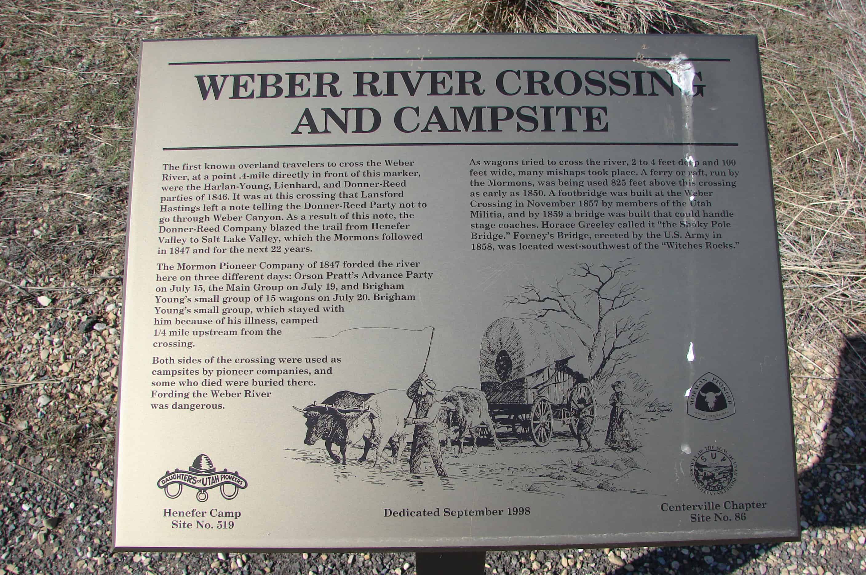
| 86 | Weber River Crossing and Campsite | Echo, Summit, Utah | Distant
Close up | N 40.98579 W 111.44867 |
| 87 | Deputy Sheriff Rodney Badger Gave His Life | Echo, Summit, Utah | Distant
Close up
| N 40.98579 W 111.44867 |
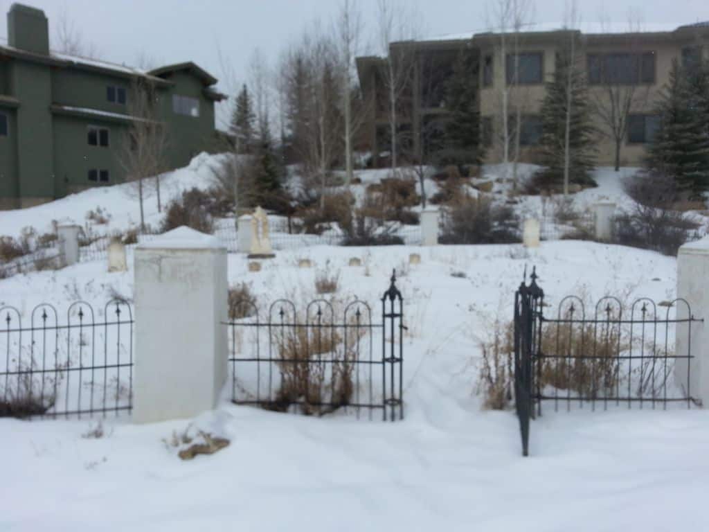
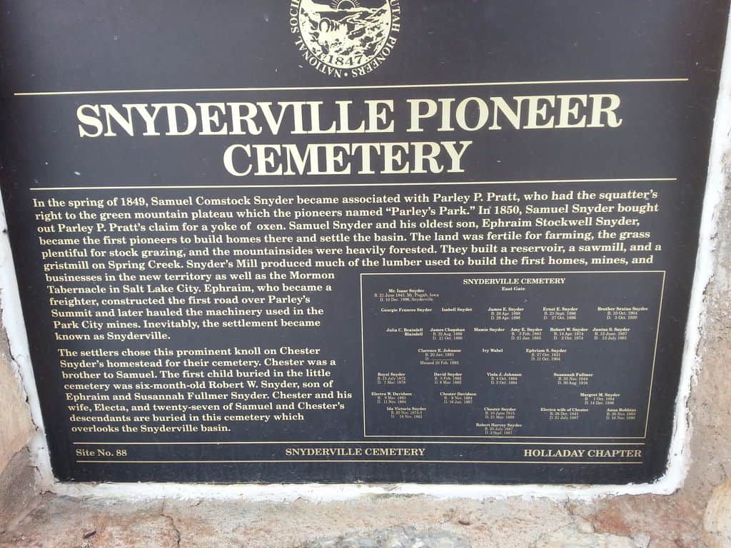
| 88 | Snyderville Pioneer Cemetery | Snyderville, Summit, Utah | Distant
Close up | N 40.69789 W 111.54547 |
| 89 | Mt. Olympus Senior Center Flag Pole | Holladay, Salt Lake, Utah | Photo | N 40.66728 W 111.84522 |
| 90 | Old Tooele County Courthouse | Tooele, Tooele, Utah | Distant
Close up | N 40.52952 W 112.29772 |
| 91 | Tooele City Pioneer Cemetery and Memorial Garden | Tooele, Tooele, Utah | Distant
Close up | N 40.51648 W 112.30418 |
| 92 & 48 | Buffalo Park | Lake Point, Tooele, Utah | Distant
Close up | N 40.69233 W 112.26234 |
| 93 | The Old Mill | Centerville, Davis, Utah | Distant
Close up | N 40.91613 W 111.86899 |
| 94 | Stoney Point | North Ogden Canyon, Weber, Utah | | |
| 95 | Hamblin Cemetery | Hamblin, Washington, Utah | | N 37.53631 W 113.60770 |
| 96 | Angels Are Near Us | Salt Lake City, Salt Lake, Utah | | (This is the Place Heritage Park) |
| 97 | Tooele City Pioneer Memorial | Tooele, Tooele, Utah | Distant
Close up | N 40.53091 W 112.30248 |
| 98 | Carlisle Family Historical Marker | Salt Lake City, Salt Lake, Utah | Distant
Close up | N 40.68733 W 111.92152 |
| 99.1 | Civilian Conservation Corps 1933-1942(Camp FS-18: Blue Spring Ridge) | Escalante, Garfield, Utah | | 12 –13 miles north of Escalante, in Pine Canyon, near Posey Lake, on the road to Hell’s Backbone. |
| 99.2 | Civilian Conservation Corps 1933-1942(Camp FS-44: Posey Lake) | Escalante, Garfield, Utah | | 1 mile south of Posey Lake at “Aspen Grove” |
| 100 | Builders of the Historic Hurricane Canal 1893-1905 | Hurricane, Washington, Utah | | |
| 101 | Evans Grain & Elevator Co-op | Lincoln, Bonneville, Idaho | | N 43.51146 W 111.97336 |
| 101-B | The Historic Hurricane Canal | Hurricane, Washington, Utah | Distant
Close up | N 37.18315 W 113.27840 |
| 103 | 1902 Steam Engine | | | N 43.51146 W 111.97336 |
| 104 | Weber College – The Moench Building | Ogden, Weber, Utah | Distant
Close up | N 41.22121 W 111.96497 |
| 105 | Lincoln Sugar Factory Steam Engine | Lincoln, Bonneville, Idaho | | N 43.51146 W 111.97336 |
| 108 | Civilian Conservation Corps 1933-1942(Camp FS-42: The Spring) | Escalante, Garfield, Utah | | 1 mile east of Escalante at “The Spring” |
| 109 | Civilian Conservation Corps 1933-1942(Camp 211, Main Canyon) | Escalante, Garfield, Utah | | 12 miles west of Escalante at Water Canyon in Main Canyon |
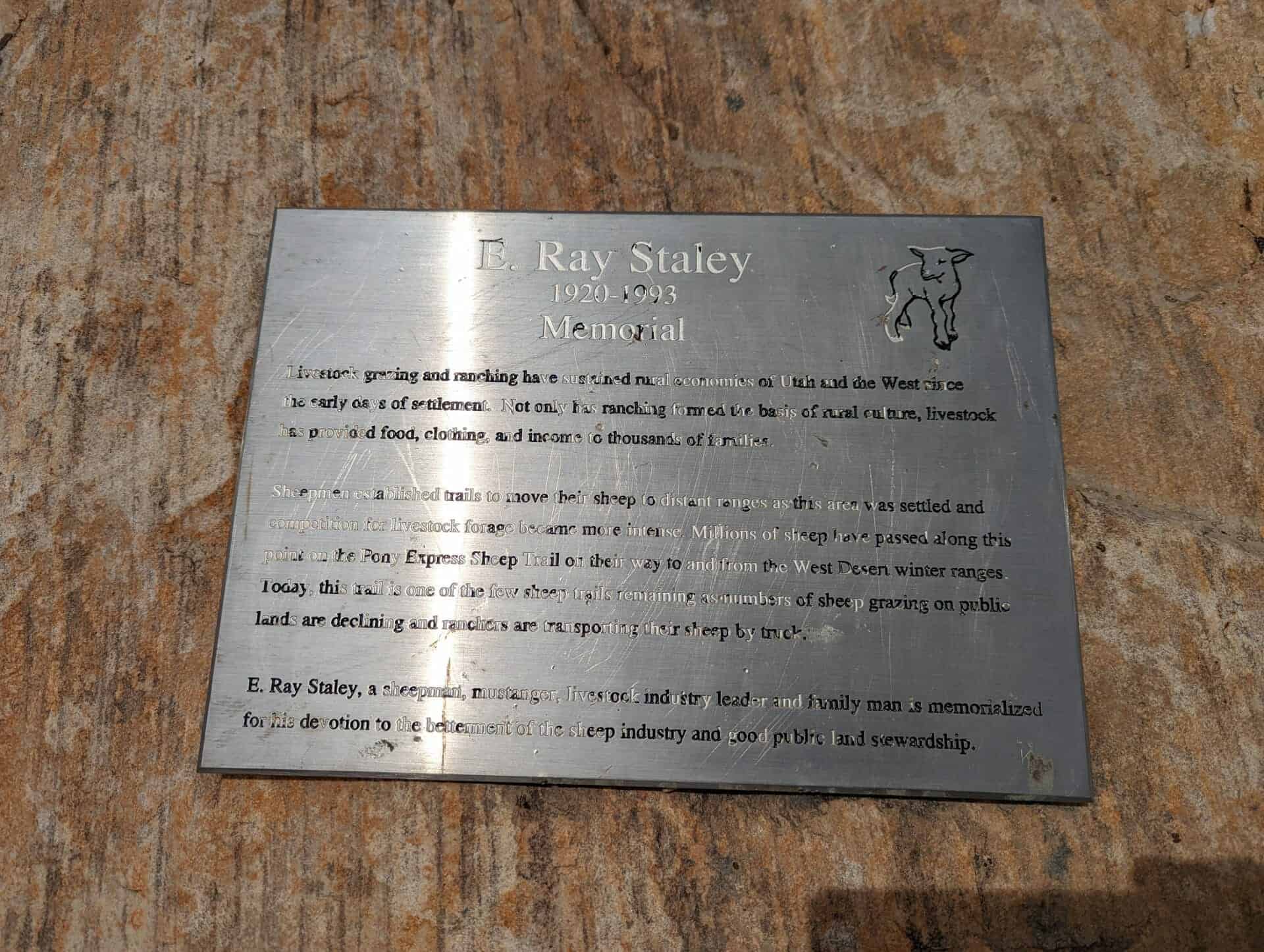
| 110.1 | Memories at Mountain Dell | Little Dell Res., Salt Lake, Utah | | N 40.77818 W 111.68902 |
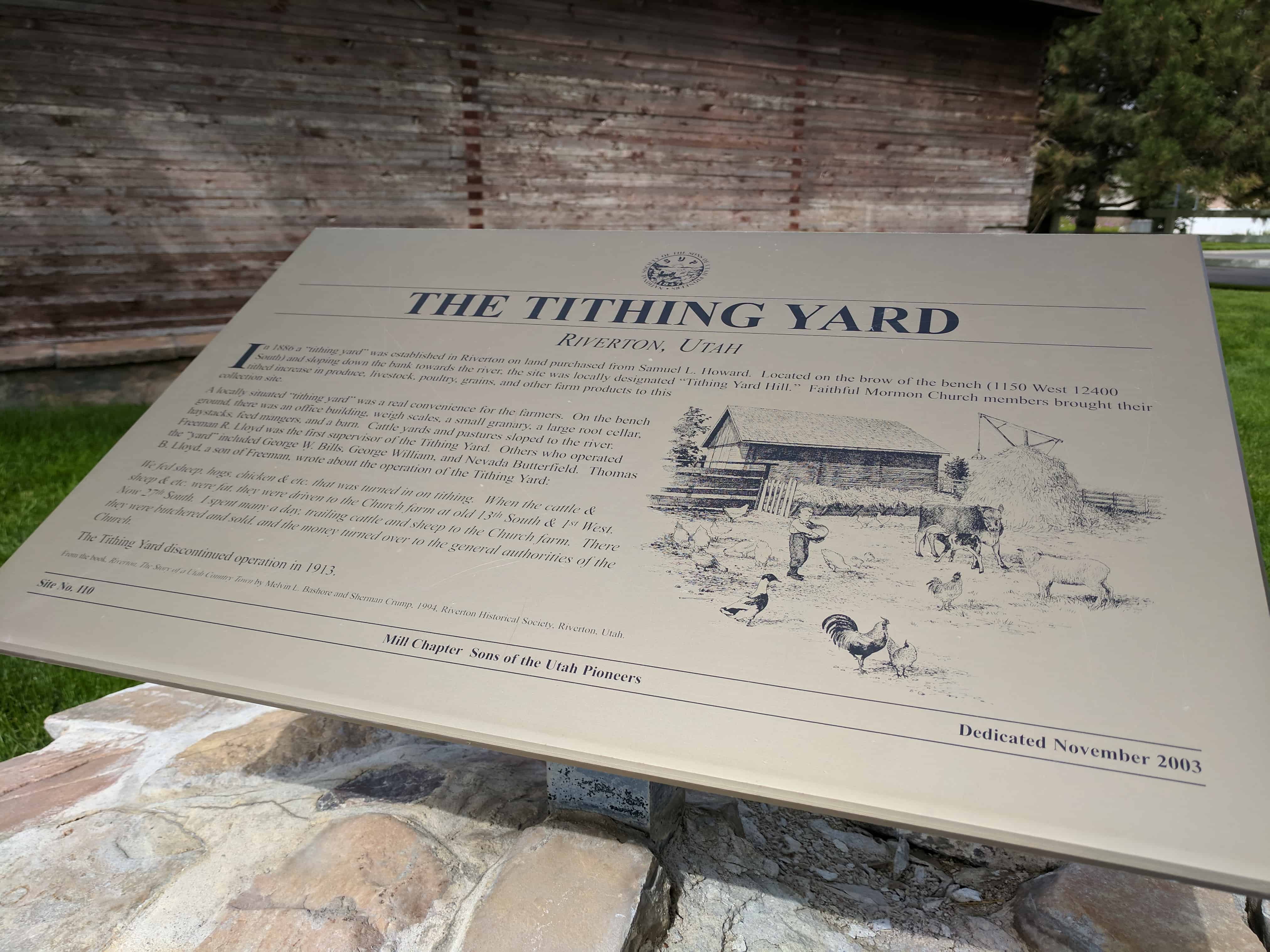
| 110.2 | The Tithing Yard | Riverton, Salt Lake, Utah | | N 40.52569 W 111.92522 |
| 110.3 | Jeremiah Willey Cabin | Bountiful, Davis, Utah | | N 40.89280 W 111.88105 |
| 111 | Early Rexburg | Rexburg, Madison, Idaho | | N 43.82701 W 111.78421 |
| 112 | Shem, Shivwits Indian Chieftain | St. George, Washington, Utah | Close up | N 37.10742 W 113.56968 |
| 116 | Freedom and Faith (Mormon Hollow) | Wallace, Chester, Pennsylvania | | |
| 117 | Millrace | Taylorsville, Salt Lake, Utah | Close up | N 40.65452 W 111.92462 |
| 118 | Richville Cemetery | Richville, Morgan, Utah | Distant
Close up | N 41.00215 W 111.68952 |
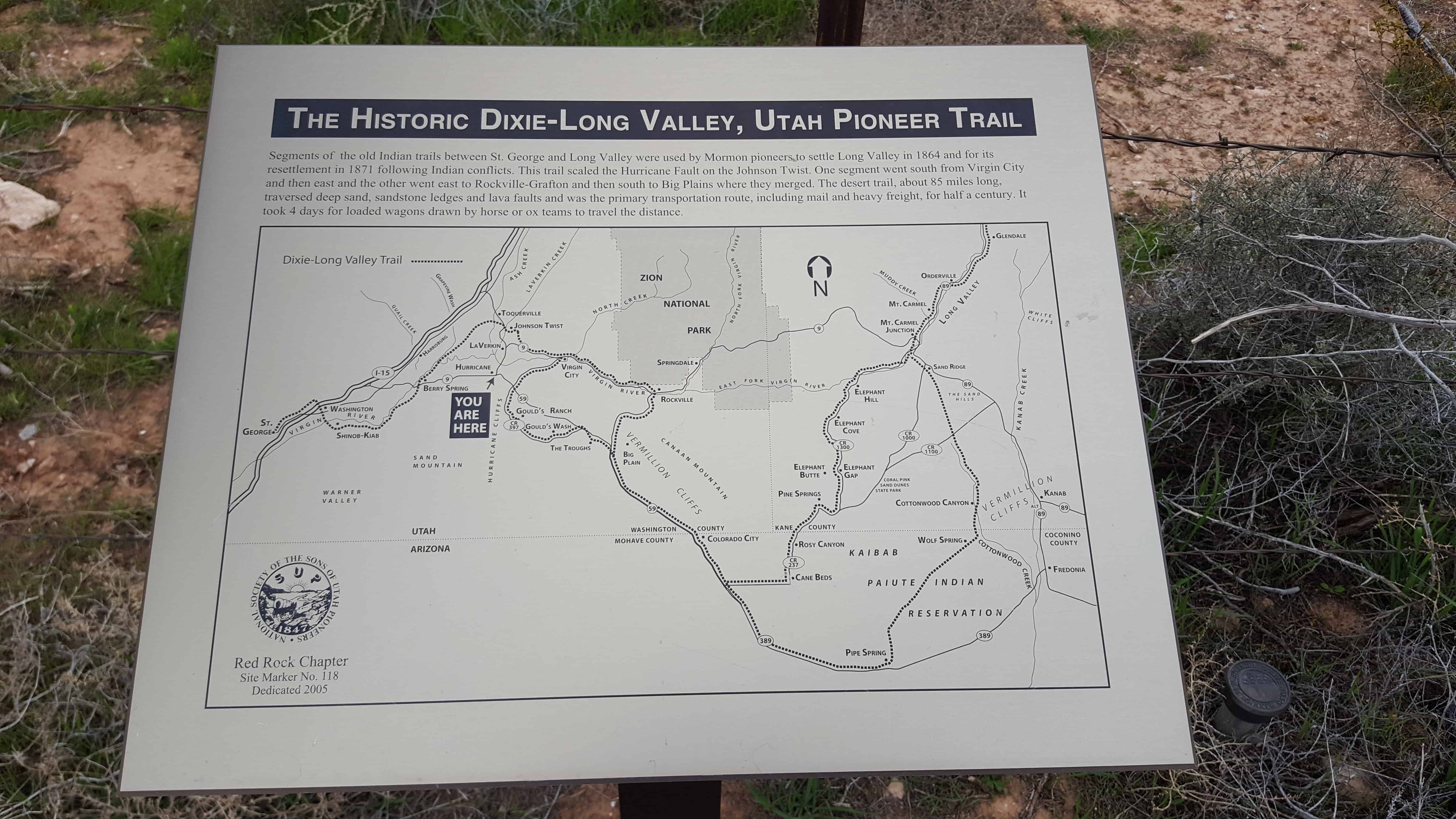
| 118.1 | The Historic Dixie-Long Valley, Utah Pioneer Trail | Hurricane, Washington, Utah | Distant
Close up | N 37.18313 W 113.27842 |
| 119 | The Historic Dixie-Long Valley, Utah Pioneer Trail | Stoneman Lake, Coconino, Arizona | Distant
Close up | N 36.94700 W 112.95547 |
| 120 | The Historic Dixie-Long Valley, Utah Pioneer Trail | Mt. Carmel Junction, Kane, Utah | | Highway 89, .25 miles south Mt. Carmel Junction |
| 122 | Logan to Brigham Pioneer Pony Express Mail Trail | Mantua, Box Elder, Utah | | Mantua Town Square |
| 123 | Wood for Pine Valley Chapel and Salt Lake Tabernacle Organ | Pine Valley, Washington, Utah | Distant
Close up | N 37.39156 W 113.51469 |
| 124 | Gould’s Sheep Shearing Mill | Hurricane, Washington, Utah | | |
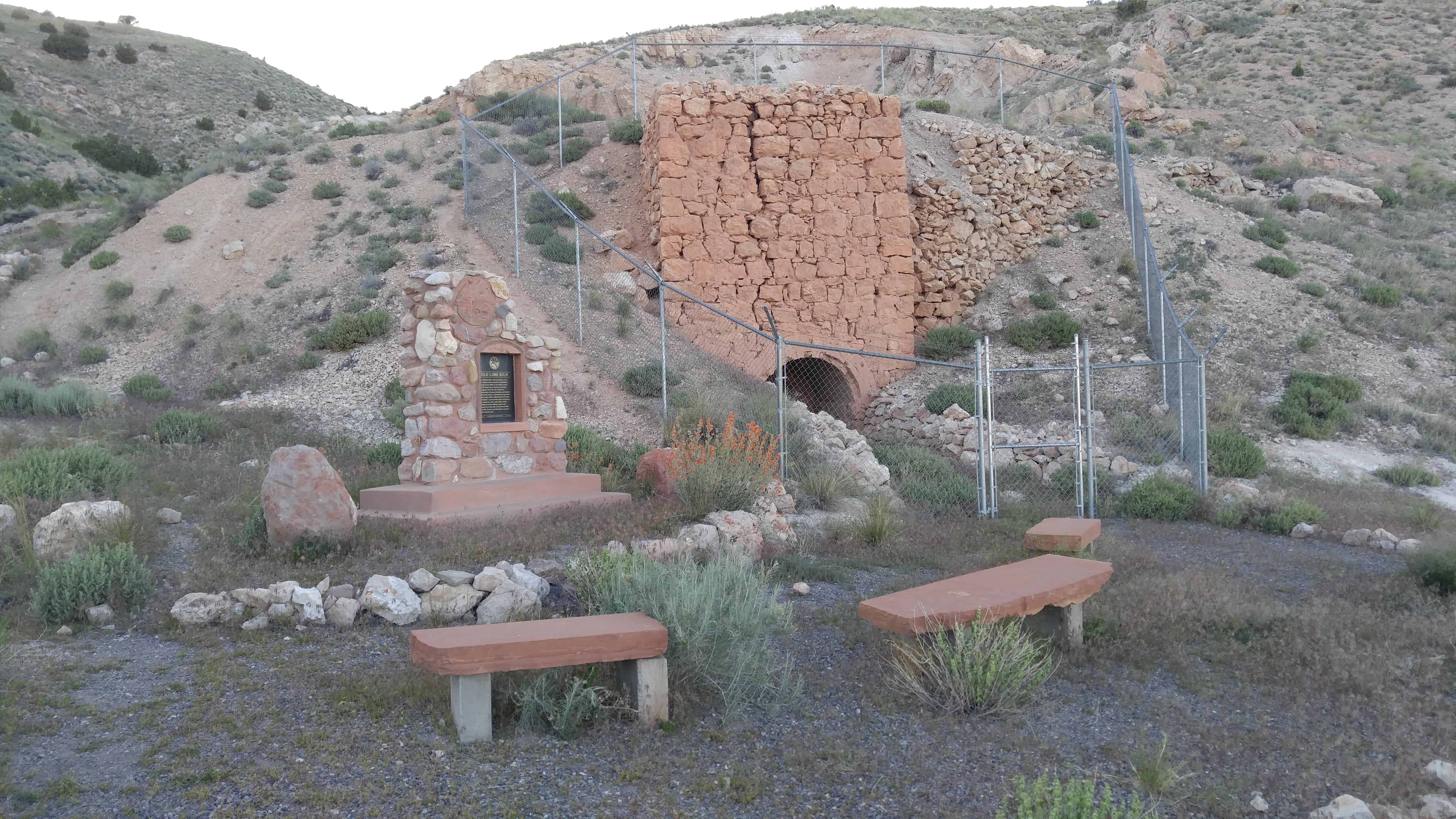
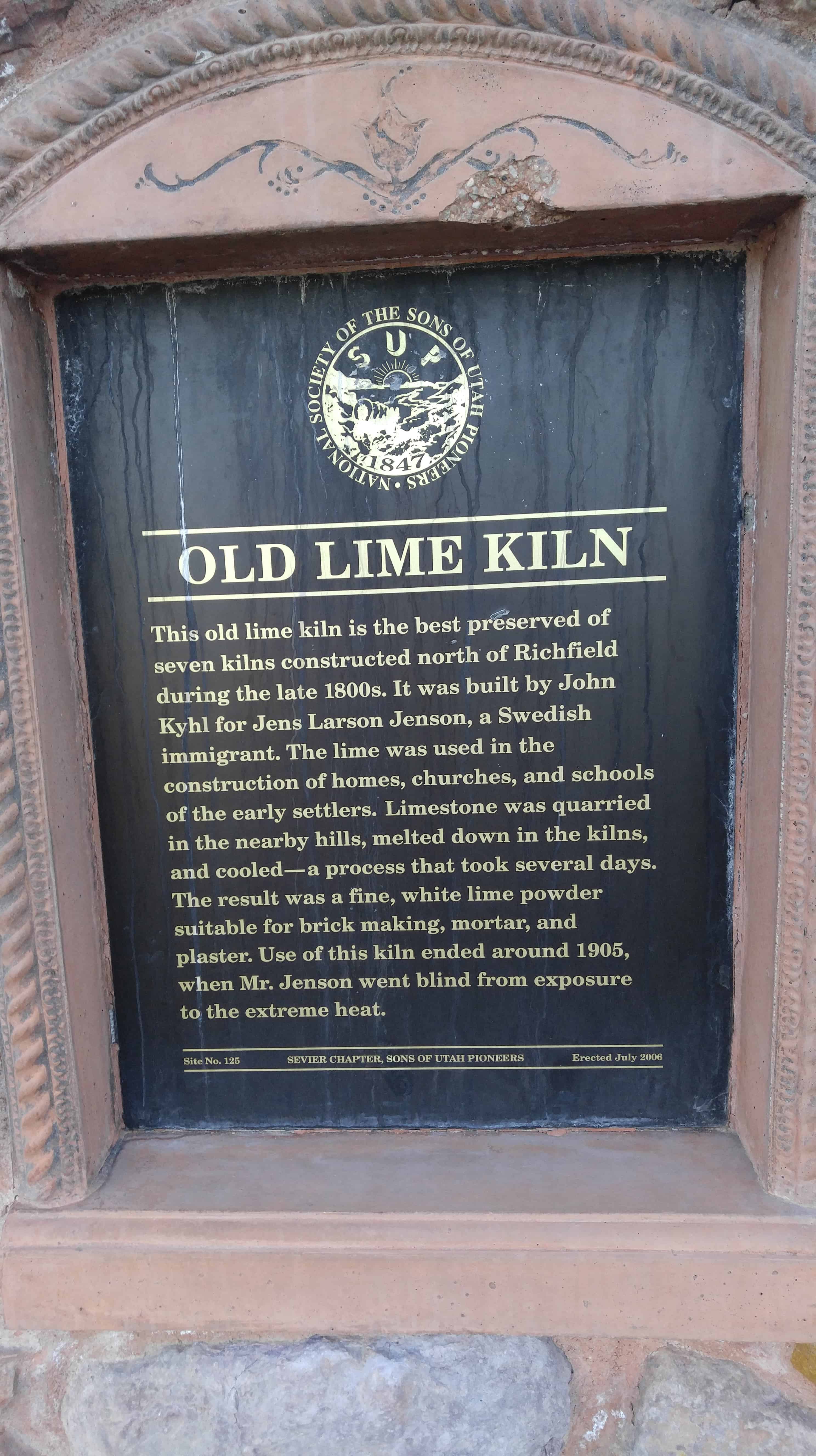
| 125 | Old Lime Kiln | Richfield, Sevier, Utah | Distant
Close up | N 38.793444 W 112.085556 |
| 126 | Historic Covered Wagon Display | North Bingham Park, Bingham, Idaho | | N 43.37420 W 112.16599 |
| 127 | Historic Sheepcamp Display | North Bingham Park, Bingham, Idaho | | N 43.37420 W 112.16599 |
| 128 | The Kington Fort-Morrisite War Site | South Weber, Davis, Utah | Distant
Close up | N 41.14677 W 111.96884 |
| 129 | This is the Place Restored Monument | Salt Lake City, Salt Lake, Utah | Photo | N 40.75316 W 111.81333
|
| 130 | Utah is Rich in Aviation History | St. George, Washington, Utah | | N 37.06491 W 113.59540
Near Water Tank off Sir Monte |
| 131 | Sawmill Road | Monroe, Sevier, Utah | Distant
Close up | N 38.62840 W 112.12834 |
| 132 | Welsh Settlement | Taylorsville, Salt Lake, Utah | Distant
Close up | N 40.67437 W 111.90845 |
| 133 | Original Pioneer Settlers of Weber County Who Arrived with Their Families in 1848 | Ogden, Weber, Utah | | N 41.21950 W 111.97110
Second floor hallway in the Ogden City Municipal Bldg. |
| 134 | Southern Exploring Company 1849 Parley P. Pratt Southern Utah Expedition | Hurricane, Washington, Utah | | North end of Main Street |
| 135 | Parley P. Pratt – Southern Exploring Company, 1849 | La Verkin, Washington, Utah | | Far west end of Center Street |
| 136 | 1997 Sesquicentennial Trekkers | Salt Lake City, Salt Lake, Utah | Distant
Close up | N 40.70849 W 111.80177 |
| 137 | Wilford Woodruff’s Farm 1850 | Salt Lake City, Salt Lake, Utah | Distant
Close up | N 40.73455 E 248.12312 |
138 & UPTLA64
& SUPK | Pioneer Flour Mill Site | Holladay, Salt Lake, Utah | Distant
Close up | N 40.69662 W 111.81517 |
| 139 | The History of the Lehi Sugar Factory | Lehi, Utah, Utah | Distant
Close up | N 40.69662 W 111.81517 |
| 140 | Eyes Westward Statue | Salt Lake City, Salt Lake, Utah | | N 40.75257 W 111.81561
(This is the Place Heritage Park) |
| 141 | A Historical Event | Escalante, Garfield, Utah | | About 18 miles north of Escalante, on the mountain road to Loa. |
| 142 | Early Morgan County Settlers | Morgan, Morgan, Utah | Distant
Close up | N 41.036622 W 111.677853 |
| 143 | Emigration Canyon Monument | Salt Lake City, Salt Lake, Utah | Distant
Close up | N 40.75005 W 111.81070 |
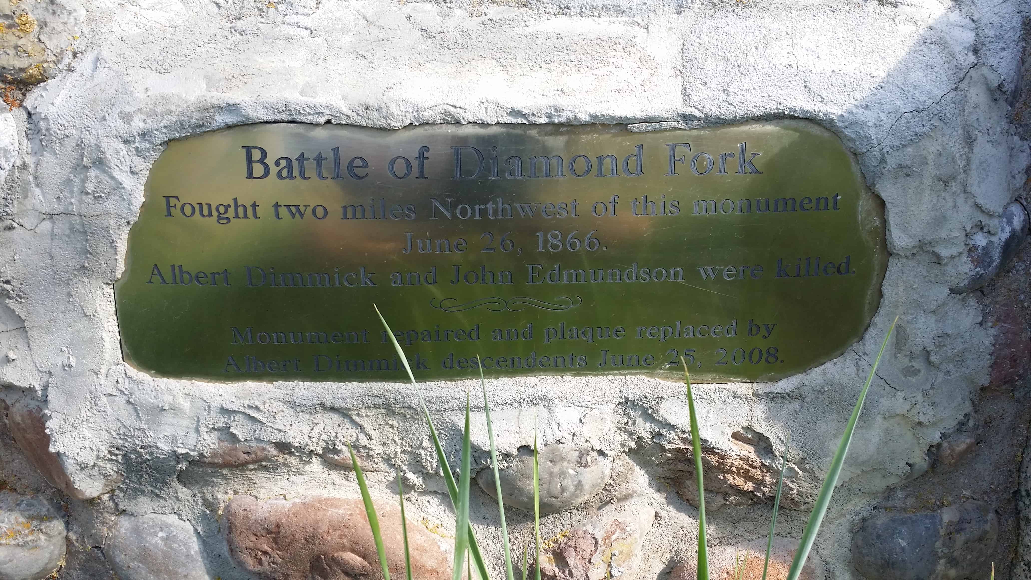
| 145 | Battle of Diamond Fork | Diamond Fork, Utah, Utah | Distant
Close up | N 40.06974 W 111.43593 |
| 146 | Peace Treaty – Blackhawk War | Heber City, Wasatch, Utah | Distant
Close up | N 40.51146 W 111.41142 |
| 147 | Tooele’s Mud Wall | Tooele, Tooele, Utah | Distant
Close up | N 40.53073 W 112.30159 |
| 148 | Historic Brigham City Relief Society Granary | Brigham City, Box Elder, Utah | Distant
Close up | N 40.53250 W 112.30159 |
| 149 | Utah Lake Fishing Industry | Provo, Utah, Utah | Distant
Close up | N 40.24193 W 111.66702 |
| 150 | Bodil Mortensen Statue | Salt Lake City, Salt Lake, Utah | | N 40.75294 W 111.81623
(This is the Place Heritage Park) |
| 151 | Joseph Allen Taylor & Chet Taylor - Innovative Farmers | Idaho Falls, Bonneville, Idaho | | N 43.41009 W 111.99724 |
| 152 | Kirkpatrick Cabin | North Bingham Park, Bingham, Idaho | | N 43.37420 W 112.16599 |
| 153 | 1900 Baptismal Site | Taylorsville, Salt Lake, Utah | Distant
Close up | N 40.66423 W 111.93351 |
| 154 | Our Sweet Three Year Old Daughter | Holladay, Salt Lake, Utah | Distant
Close up | N 40.66272 W 111.83102 |
| 155 | Early Morgan Pioneers | Morgan, Morgan, Utah | Distant
Close up | N 41.04065 W 111.67484 |
| 156 | Russon & Peck Immigration | Lehi, Utah, Utah | Distant
Close up | N 40.39906 W 111.82462 |
| 157 | Spencer and Helen Isom “Home” | Hurricane, Washington, Utah | | 36 North 100 West |
| 158 | Hornet Hill Monument | Kolob, Washington, Utah | | N 37.48959 W 113.01945 |
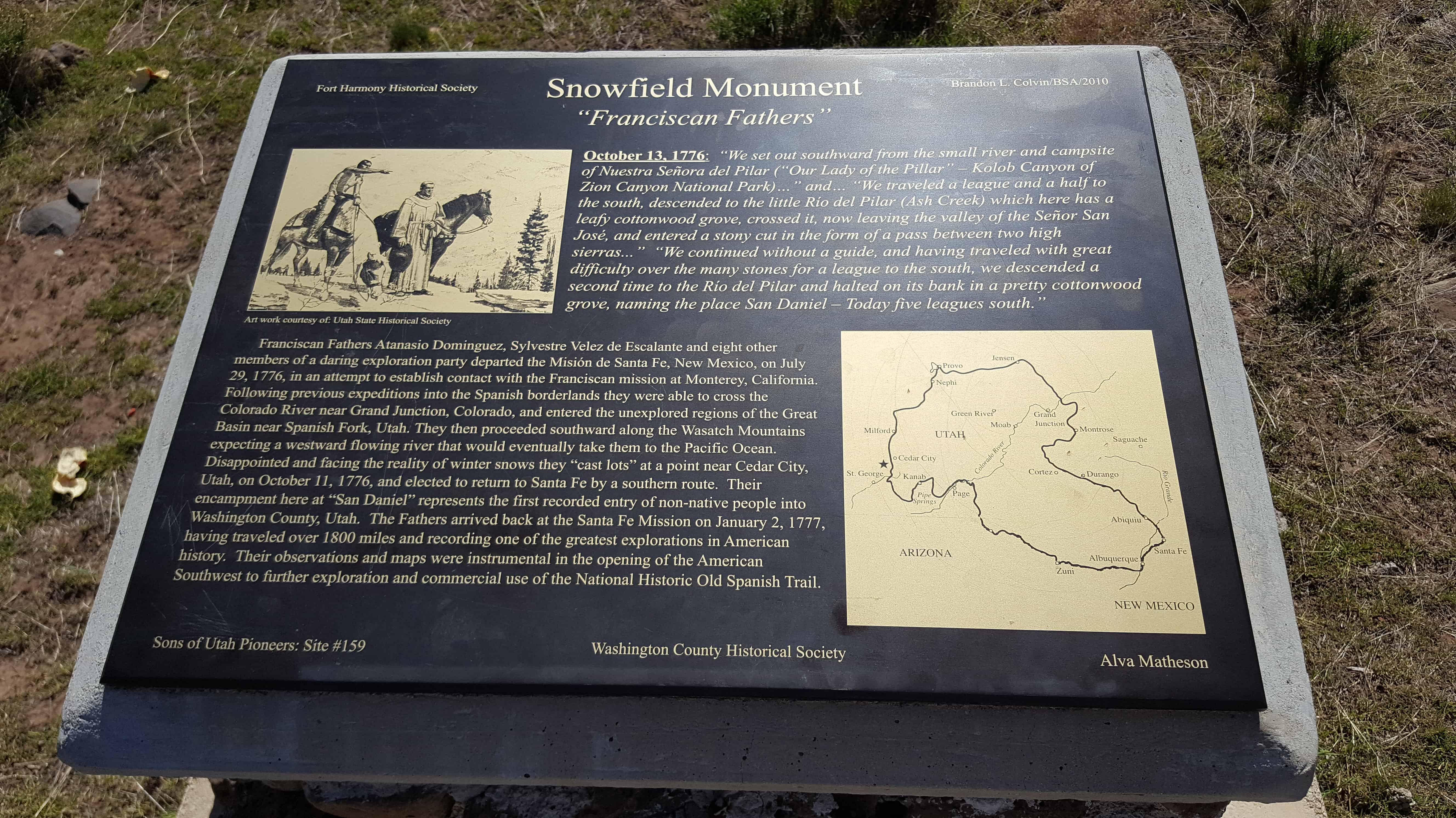
| 159 | Snowfield Monument “Franciscan Fathers” | Snowfield, Washington, Utah | Distant
Close up | N 37.40502 W 113.23739 |
| 160 | Sacred Heart Academy | Ogden, Weber, Utah | | N 41.22082 W 111.95438
950 – 25th St. Ogden, Utah, inside entrance to State Bldg. at the site of original Academy. |
| 161 | Rexburg Public Square | Rexburg, Madison, Idaho | | |
| 162 | Pioneer School Bus | North Bingham Park, Bingham, Idaho | | N 43.37420 W 112.16599 |
| 163 | Broom Factory and Wagon Train Terminal | Salt Lake City, Salt Lake, Utah | | N 40.60926 W 111.94829
2200 West and 7800 South (SW corner) |
| 164 | Harrisburg Historic Pioneer Cemetery | Harrisburg, Washington, Utah | Distant
Close up | N 37.20593 W 113.39186 |
| 165 | Shetlar Wagon | Hurricane, Washington, Utah | | To the rear of the old Bradshaw House 100 South Main |
| 166 | The Town Named After a Buggy Incident | Hurricane, Washington, Utah | | Hurricane Valley Heritage Park, Main and State St |
| 167 | George A. Smith Provo Pioneer Village | Provo, Utah, Utah | Distant
Close up | N 40.24193 W 111.66702 |
| 168 | Samuel R. Knight | Santa Clara, Washington, Utah | | 1017 West Sunset Blvd |
| 169 | Wilford Woodruff and Josephine Barbara Baumann Knight | Santa Clara, Washington, Utah | | 1017 West Sunset Blvd |
| 170 | Pioneer Graves Reburied | Tooele, Tooele, Utah | | N 40.51666 W 112.30389 |
| 171 | First Flour Mill | American Fork, Utah, Utah | Distant
Close up | N 40.38114 W 111.79737 |
| 172 | Southern Indian Mission | New Harmony, Washington, Utah | Distant
Close up | N 37.48080 W 113.24286 |
| 173 | Tonaquint | St. George, Washington, Utah | Distant
Close up | N 37.07434 W 113.58291 |
| 174 | Brigham Young's Vision | St. George, Washington, Utah | Distant
Close up | N 37.07423 W 113.58253 |
| 175 | The Southern Exploring Company | St. George, Washington, Utah | Distant
Close up | N 37.07438 W 113.58204 |
| 176 | Jedediah Strong Smith | St. George, Washington, Utah | Distant
Close up | N 37.07471 W 113.58232 |
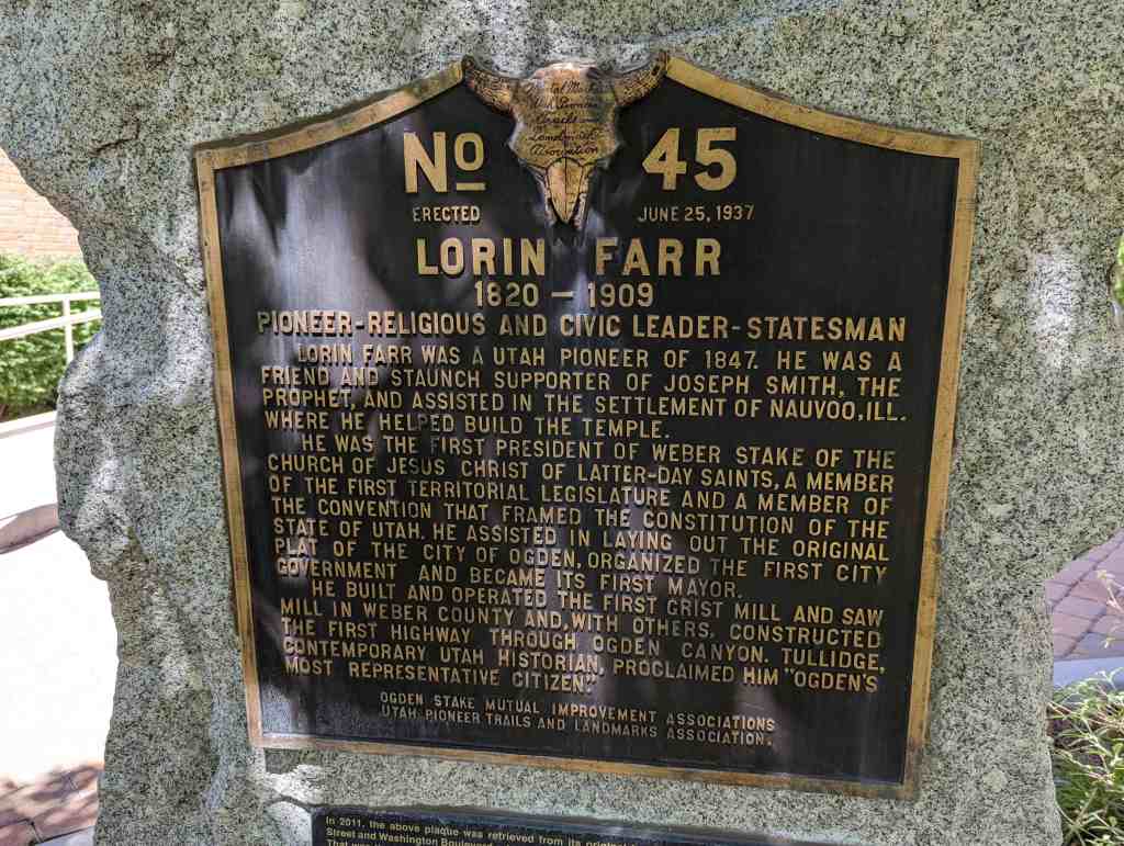
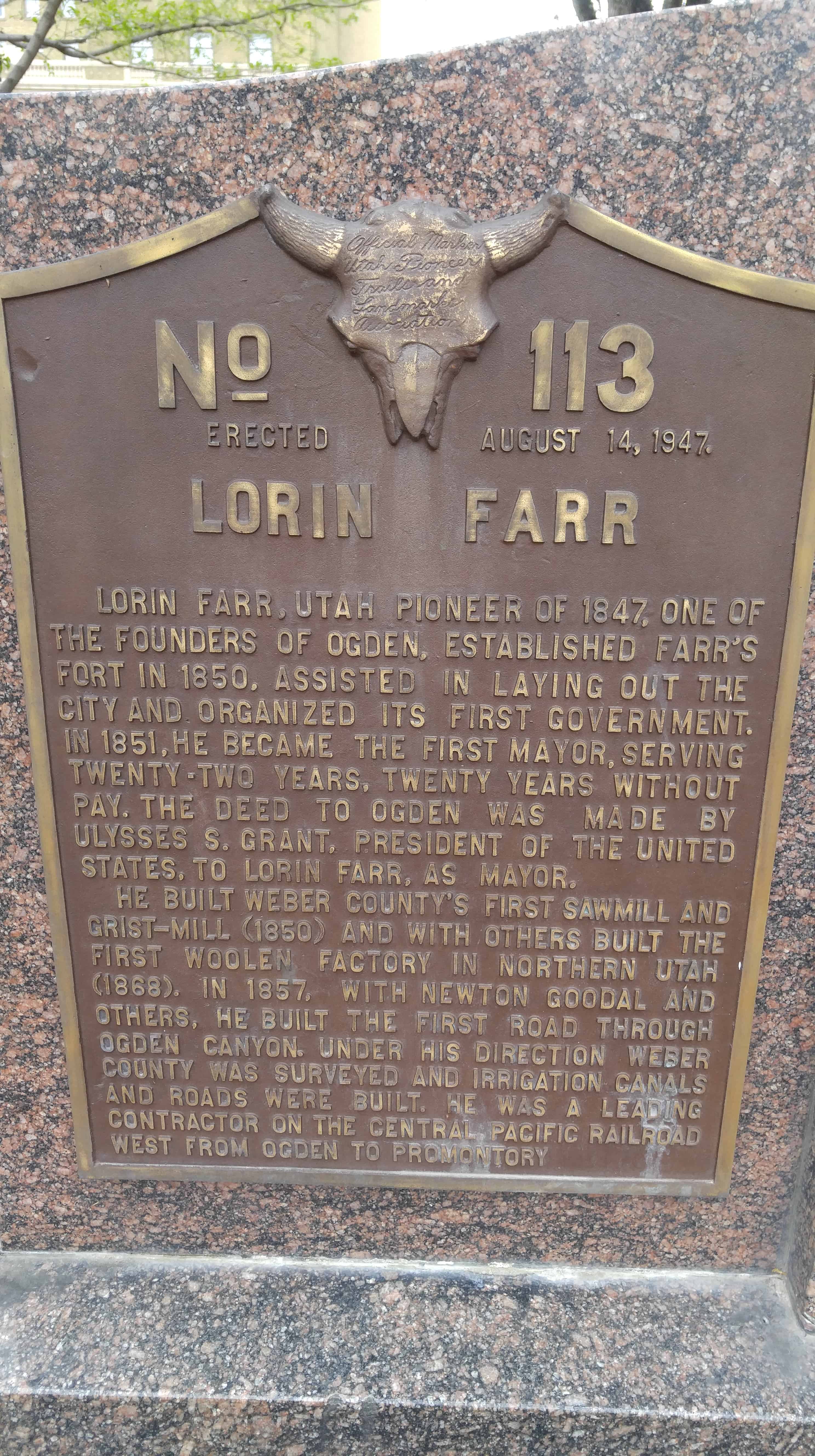
| 177 & UPTLA 45 | Lorin Farr | Ogden, Weber, Utah | Distant
Close up | N 41.22880 W 111.97559 |
| 178 | The Lincoln Highway | Grantsville, Tooele, Utah | Distant
Close up | N 40.60244 W 112.48232 |
| 179 | Isom’s Corner | Hurricane, Washington, Utah | Distant
Close up | N 37.17641 W 113.28873 |
| 180 | Rexburg Tabernacle Centennial | Rexburg, Madison, Idaho | | N 43.82701 W 111.78421 |
| 182 | The Peter Julius Christofferson Family | Lehi, Utah, Utah | Distant
Close up | N 40.40658 W 111.84005 |
| 183 | John Austin Cabin | Lehi, Utah, Utah | Distant
Close up | N 40.38891 W 111.84952 |
| 184 | Major Irrigation Canals Constructed in Cache Valley | Logan, Cache, Utah | Distant
Close up | N 41.74264 W 111.78764 |
| 185-A | The Utah War - U.S. Army Sent West | Echo Canyon, Summit, Utah | Distant
Close up | N 40.98976 W 111.40272 |
| 185-B | The Utah War - The Mormon Response | Echo Canyon, Summit, Utah | Distant
Close up | N 40.98976 W 111.40272 |
| 185-C | The Utah War - Fortifying Echo Canyon | Echo Canyon, Summit, Utah | Distant
Close up | N 40.98976 W 111.40272 |
| 185-D | The Utah War - Diplomacy Prevails | Echo Canyon, Summit, Utah | Distant
Close up | N 40.98976 W 111.40272 |
| 186 | Hansen Dairy | Beaver Dam, Box Elder, Utah | Distant
Close up | N 41.77419 W 112.06031 |
| 187 & 51 | Little Mountain Summit | Emigration Canyon, Salt Lake, Utah | Distant
Close up | N 40.77495 W 111.71830 |
| 189 | Log Cabin Grist Mill | American Fork, Utah, Utah | Distant
Close up | N 40.37068 W 111.79976 |
| 190 | Wight’s Fort Cemetery | West Jordan, Salt Lake, Utah | Distant
Close up | N 40.58764 W 111.97424 |
| 191 | National Woman’s Relief Society | Nauvoo, Hancock, Illinois | | |
| 192 | Leaning into the Light | Salt Lake City, Salt Lake, Utah | Distant
Close up | N 40.77024 W 111.89053 |
| 193 | Flagpole at SUP Headquarters Bldg. | Salt Lake City, Salt Lake, Utah | Distant
Close up | N 40.70849 W 111.80177 |
| 194 | Mormon Pioneers at Independence Rock | Independence Rock, Natrona, Wyoming | | (missing?) |
| 195 | Box Elder Academy of Music and Dancing | Brigham City, Box Elder, Utah | Distant
Close up | N 41.51176 W 112.01554 |
| 196 | Box Elder Courthouse | Brigham City, Box Elder, Utah | Distant
Close up | N 41.51031 W 112.01556 |
| 197 | Brigham City Gateway Arch | Brigham City, Box Elder, Utah | Distant
Close up | N 41.50922 W 112.01574 |
| 198 | Brigham City Co-op Store | Brigham City, Box Elder, Utah | Distant
Close up | N 41.51056 W 112.01596 |
| 199 | Bushnell Hospital/Intermountain Indian School | Brigham City, Box Elder, Utah | | N 41.48902 W 112.00918 |
| 200 | The Davis Fort | Brigham City, Box Elder, Utah | Distant
Close up | N 41.52482 W 112.02192 |
| 201 | First Ward Meeting House | Brigham City, Box Elder, Utah | | 311 S 100 E |
| 202 | Grist Mill | Brigham City, Box Elder, Utah | Distant
Close up | N 41.51486 W 112.00952 |
| 203 | Old City Hall/Fire Station | Brigham City, Box Elder, Utah | Distant
Close up | N 41.51067 W 112.01558 |
| 204 | Planing Mill – Built 1875 | Brigham City, Box Elder, Utah | | N 41.51048 W 112.00629 |
| 205 | Tithing Office | Brigham City, Box Elder, Utah | Distant
Close up | N 41.50904 W 112.01735 |
| 206 | Union Pacific Depot – Built 1907 | Brigham City, Box Elder, Utah | Distant
Close up | N 41.51040 W 112.02930 |
| 207 | Woolen Mill - Built 1870 | Brigham City, Box Elder, Utah | | N 41.51165 W 112.00775 |
| 208 | Settlement of Provo in 1849 | Provo, Utah, Utah | Distant
Close up | N 40.24138 W 111.66703 |
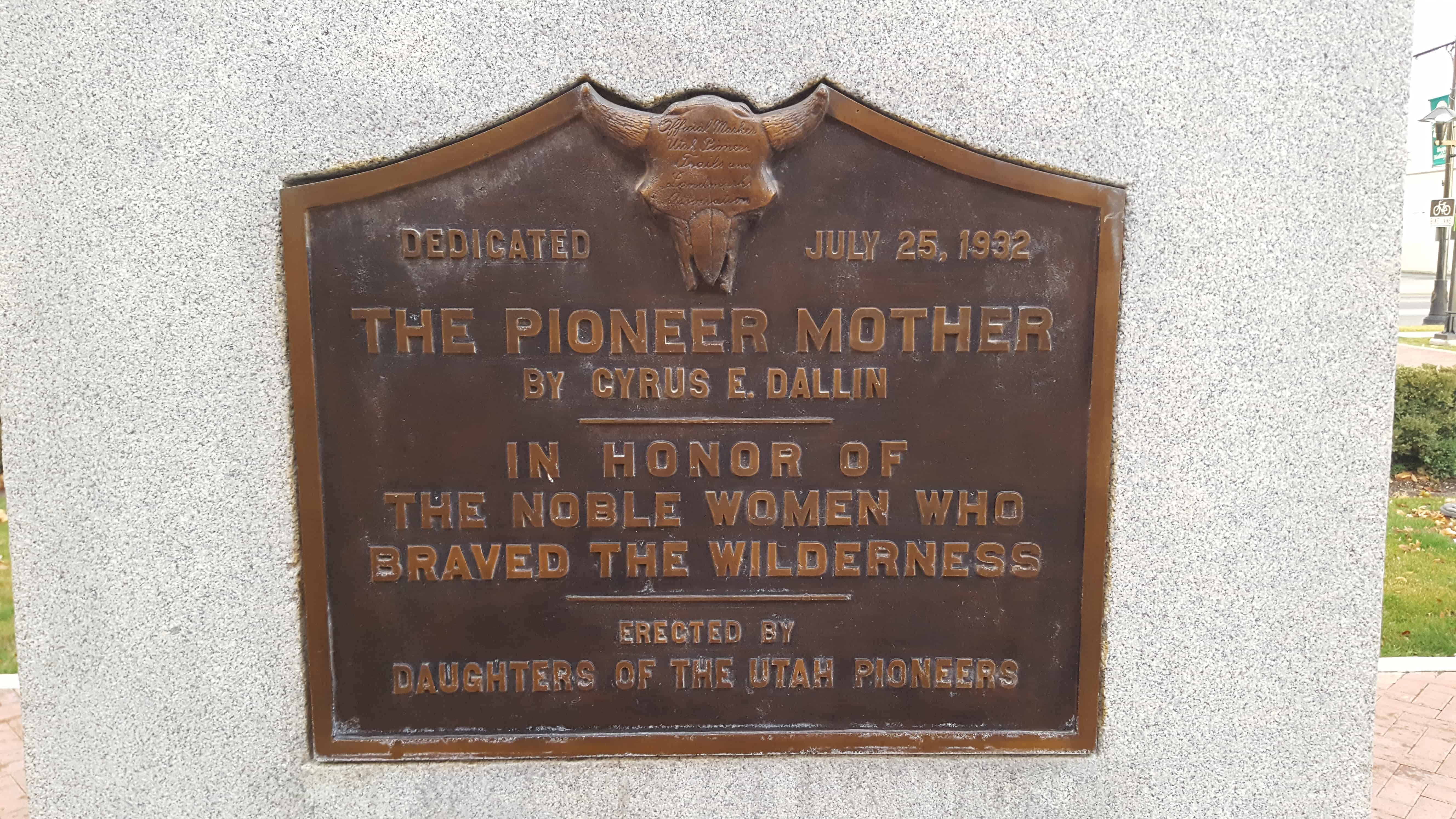
| 209 | The Pioneer Mother | Springville, Utah, Utah | Distant
Close up | N 40.16517 W 111.61109 |
| 210 | Pioneer Handcart | Ogden, Weber, Utah | Distant
Close up | N 41.22884 W 111.97547 |
| 211 | Bennion Ward Memorial | Taylorsville, Salt Lake, Utah | | N 40.63989 W 111.94222 |
| 212 | Honoring Servicemen | Taylorsville, Salt Lake, Utah | Distant
Close up | N 40.67452 W 111.90895 |
| 213A | Blackfoot Land Office | Blackfoot, Bingham, Idaho | | N 43.18872 W 112.34308 |
| 214 | The Founding of Southern Utah University and Old Sorrel Statue | Cedar City, Iron, Utah | Distant
Close up | N 37.67608 W 113.07350 |
| 215 | The Founders’ Rescue Wagon | Cedar City, Iron, Utah | Distant
Close up | N 37.67556 W 113.07214 |
| 216 | Parowan Cotton Factory | Parowan, Iron, Utah | | |
| 217 | Hebron Cemetery | Hebron, Washington, Utah | | N 37.59038 W 113.82541 |
| 218 | Adair Spring The Birthplace of Utah’s Dixie | Washington, Washington, Utah | | 120 North 200 East |
| 219 | Sixty-five Mile Trail from Escalante to Hole-in-the-Rock | Escalante, Garfield, Utah | | |
| 220 | Look-Out Point | Hurricane, Washington, Utah | | 50 North 100 West |
| 221 | Trailhead and Pavilion | Hurricane, Washington, Utah | | |
| 222 | Morris Wilson Memorial Park | La Verkin, Washington, Utah | | Main & Center Street |
| 223 | First Building Outside Salt Lake City for Religious & Education Instruction | Murray, Salt Lake, Utah | Distant
Close up | N 40.67891 W 111.88433 |
| 224 | Mormon Pioneer Trail, Centennial Trekkers | Salt Lake City, Salt Lake, Utah | Distant
Close up | N 40.70849 W 111.80177 |
| 225 | Nathanial (Nathan) Hawk | Coloma, El Dorado, California | | N 38.79440 W 120.88924 |
| 226 | Mormon Worker's Cabin: Gold Discovery Site | Coloma, El Dorado, California | | N 38.80148 W 120.89235 |
| 230 | Donner Hill | Salt Lake, Salt Lake, Utah | Distant
Close up | N 40.75166 W 111.80095 |
| 235 | Lookout Station | Vernon, Tooele, Utah | Distant
Close up | N 40.11968 W 112.57649 |
| 236 | Blackrock Station | Blackrock Station, Juab, Utah | Distant
Close up | N 39.87807 W 113.27152 |
| 237 | Fish Springs Station | Fish Springs, Juab, Utah | Distant
Close up | N 39.84803 W 113.41084 |
| 238 | Burnt Station | Ibapah, Tooele, Utah | Distant
Close up | N 40.07680 W 113.84556 |
| 239 | Burial Plot | Vernon, Tooele, Utah | Distant
Close up | N 40.11865 W 112.57768 |
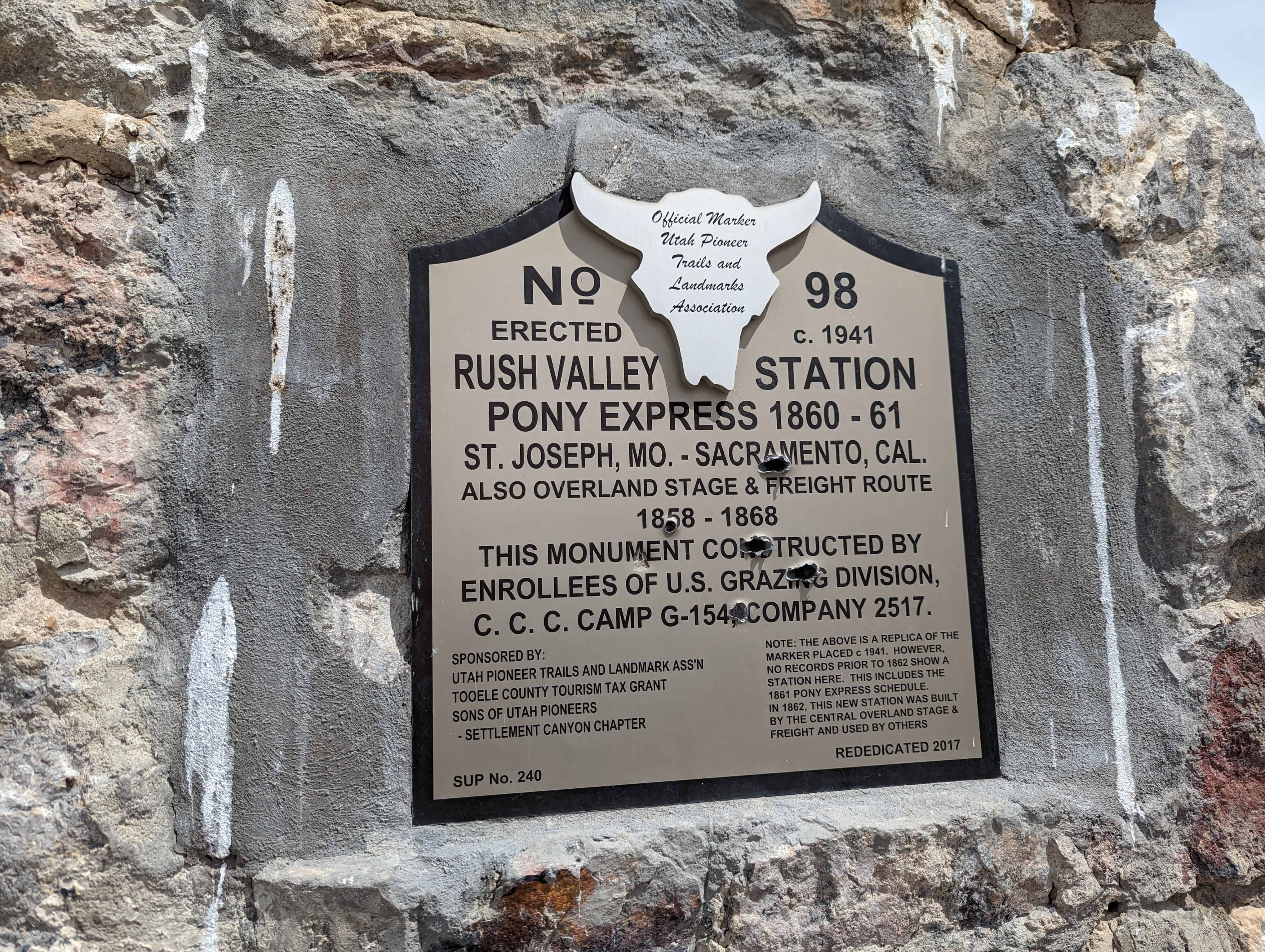
| 240 | Rush Valley Station | Rush Valley, Tooele, Utah | Distant
Close up | N 40.20646 W 112.29321 |
| 242 | Tooele Carnegie Free Public Library | Tooele, Tooele, Utah | Distant
Close up | N 40.53071 W 112.29720 |
| 243 | Tooele County Airmail Arrows and Beacons | Stockton, Tooele, Utah | Distant
Close up | N 40.45164 W 112.36279 |
| 246 | Civil War Skirmish at Pleasant Grove | Pleasant Grove, Utah, Utah | Distant
Close up | N 40.36197 W 111.73862 |
| 249 | James Lynn Bevan | Tooele, Tooele, Utah | Distant
Close up | N 40.53079 W 112.29732 |
| 276 | Soft-Rock | Pleasant Grove, Utah, Utah | Distant
Close up | N 40.36207 W 111.73863 |
| 282 | Pioneer Canal Builders of Bingham County | Blackfoot, Bingham, Idaho | | N 43.18901 W 112.34417 |
| | | | |
| UPTLA #1 | Escalante Trail | Provo, Utah, Utah | Distant
Close up | N 40.23258 W 111.65820 |
| UPTLA #2 | Cache Valley | Logan, Cache, Utah | Distant
Close up | N 41.73213 W 111.83436 |
| UPTLA #3 | Jedediah Strong Smith | Ogden, Weber, Utah | Distant
Close up | N 41.22028 W 111.97108 |
| UPTLA #4 | “Mormon” Pioneer Trail | Henefer, Summit, Utah | Distant
Close up | N 41.01791 W 111.49921 |
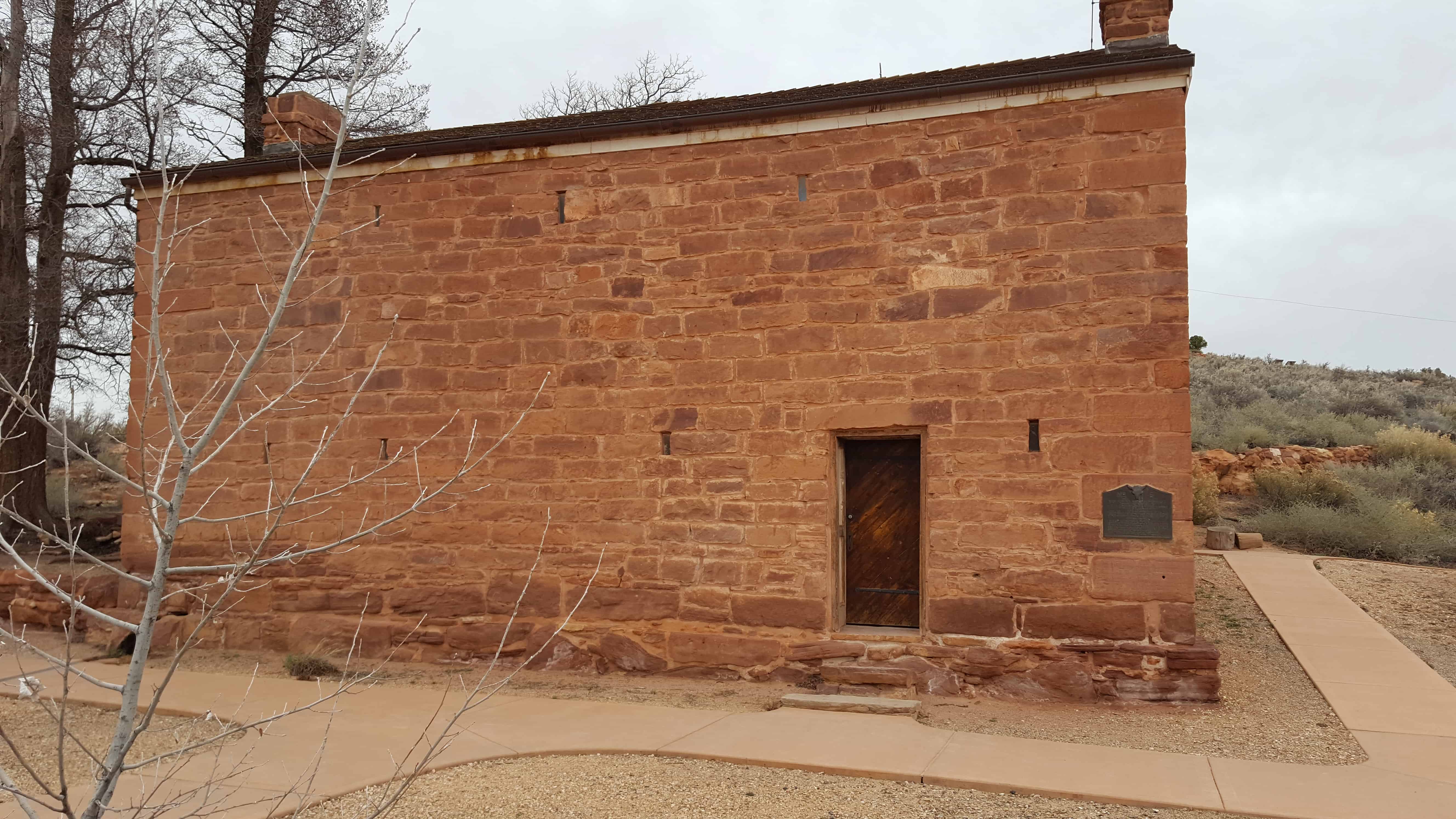
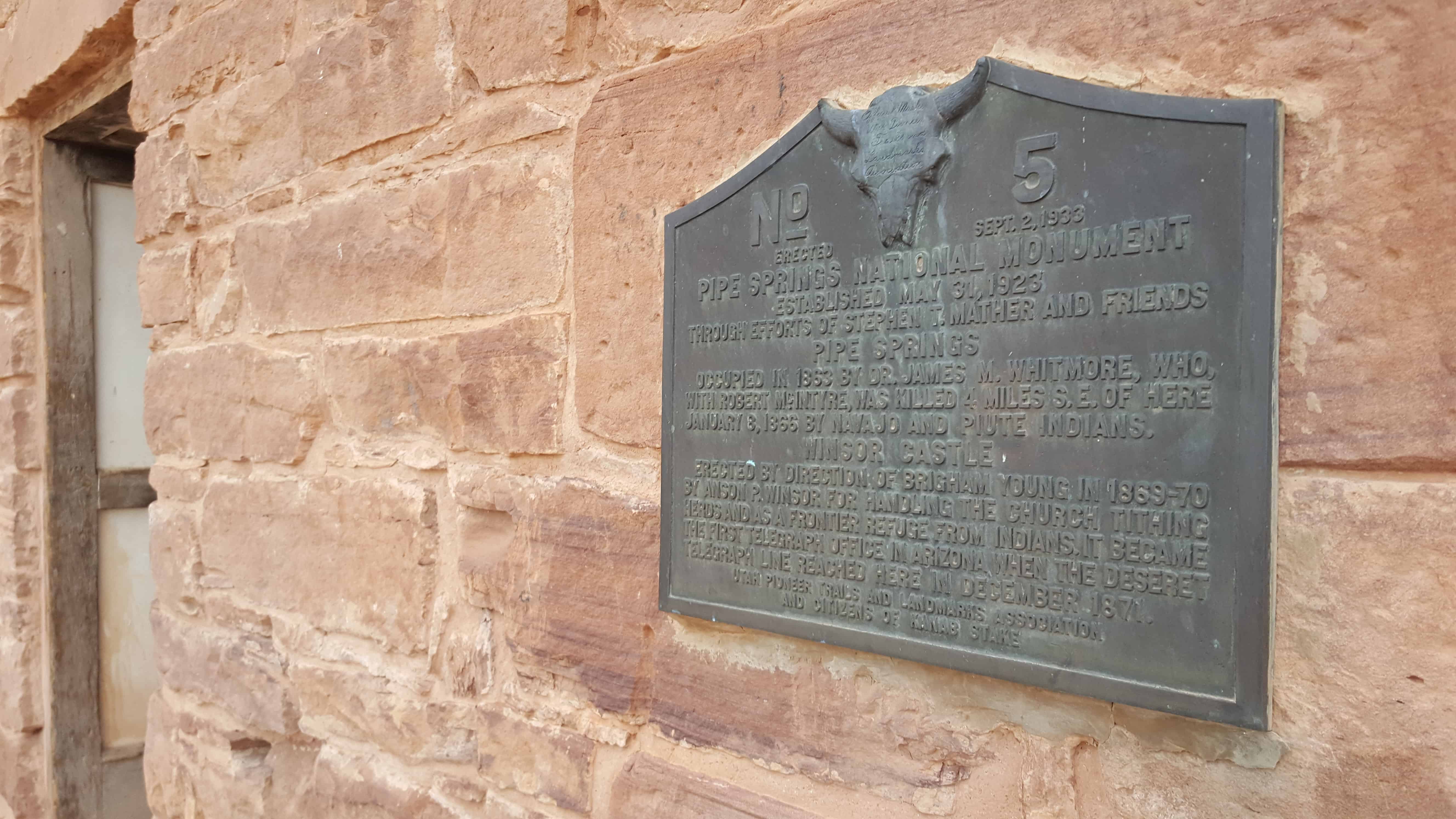
| UPTLA #5 | Pipe Springs National Monument | Pipe Springs, Coconino, Arizona | Distant
Close up | N 36.86324 W 112.73948 |
| UPTLA #6 | Peace Treaty with Fish Lake Indians | Fish Lake, Sevier, Utah | Distant
Close up | N 38.53610 W 111.73758 |
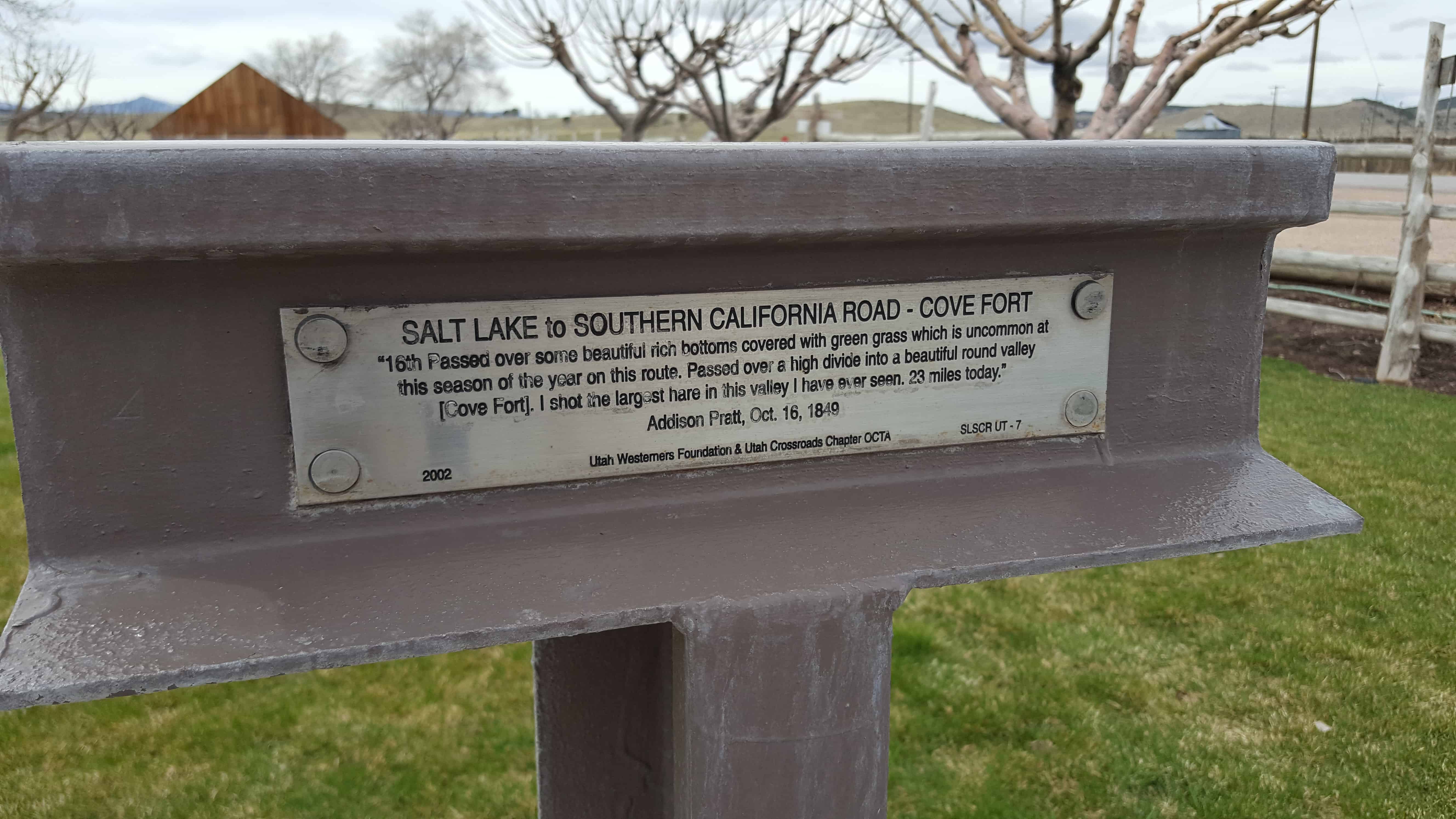
| UPTLA #7 | Donner Trail 1846 | Salt Lake City, Salt Lake, Utah | Distant
Close up | N 40.77195 W 111.92027 |
| UPTLA #8 | Pony Express Station | Salt Lake City, Salt Lake, Utah | Distant
Close up | N 40.76589 W 111.89093 |
| UPTLA #9 | The First Settlers of Logan | Logan, Cache, Utah | Distant
Close up | N 41.73257 W 111.83440 |
| UPTLA #10 | In Honor of James Bridger | Bear River, Box Elder, Utah | Distant
Close up | N 41.63548 W 112.12820 |
| UPTLA #11 | Fort Hall | Fort Hall, Bingham, Idaho | | N 43.02471 W 112.43835 |
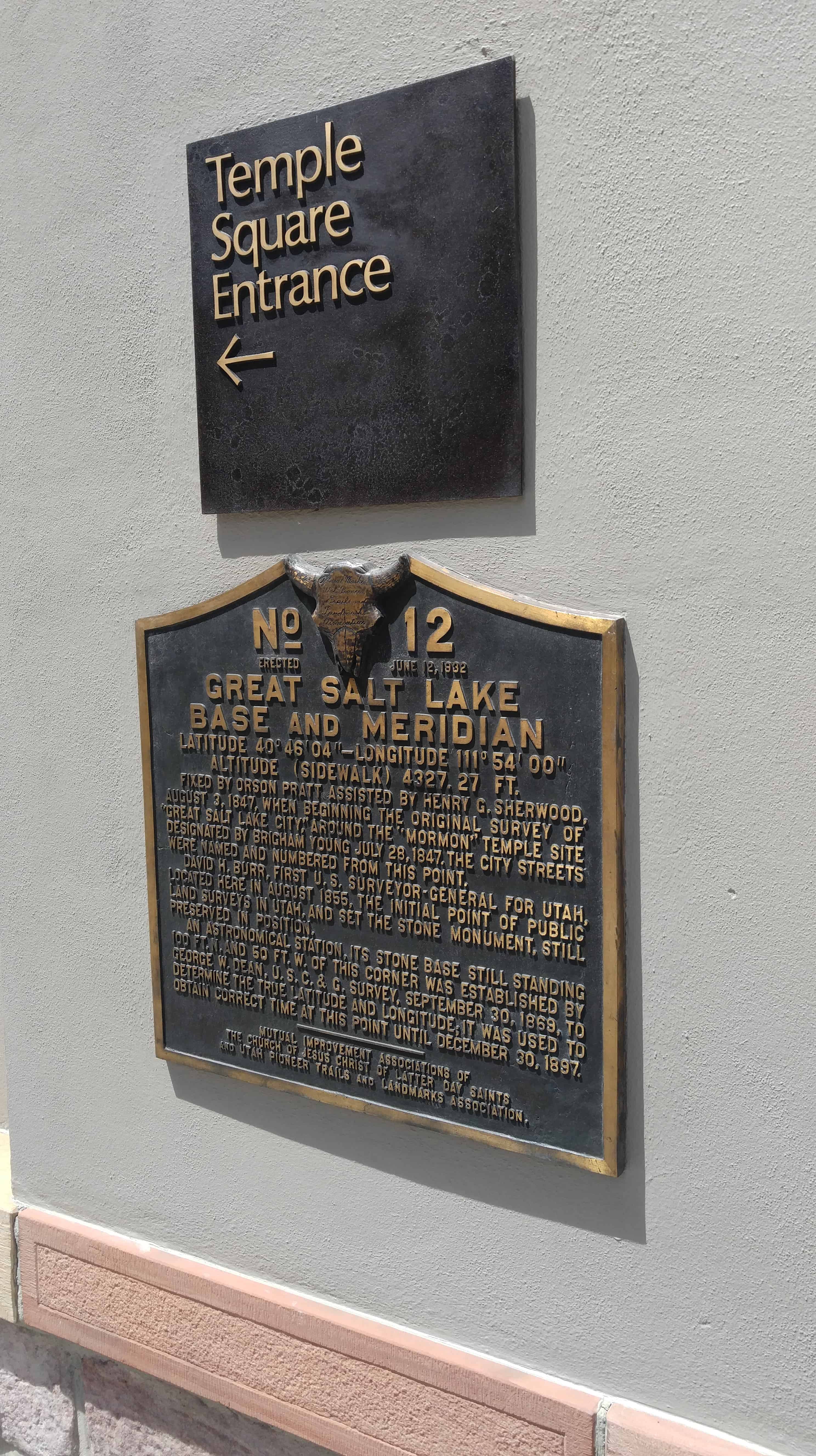
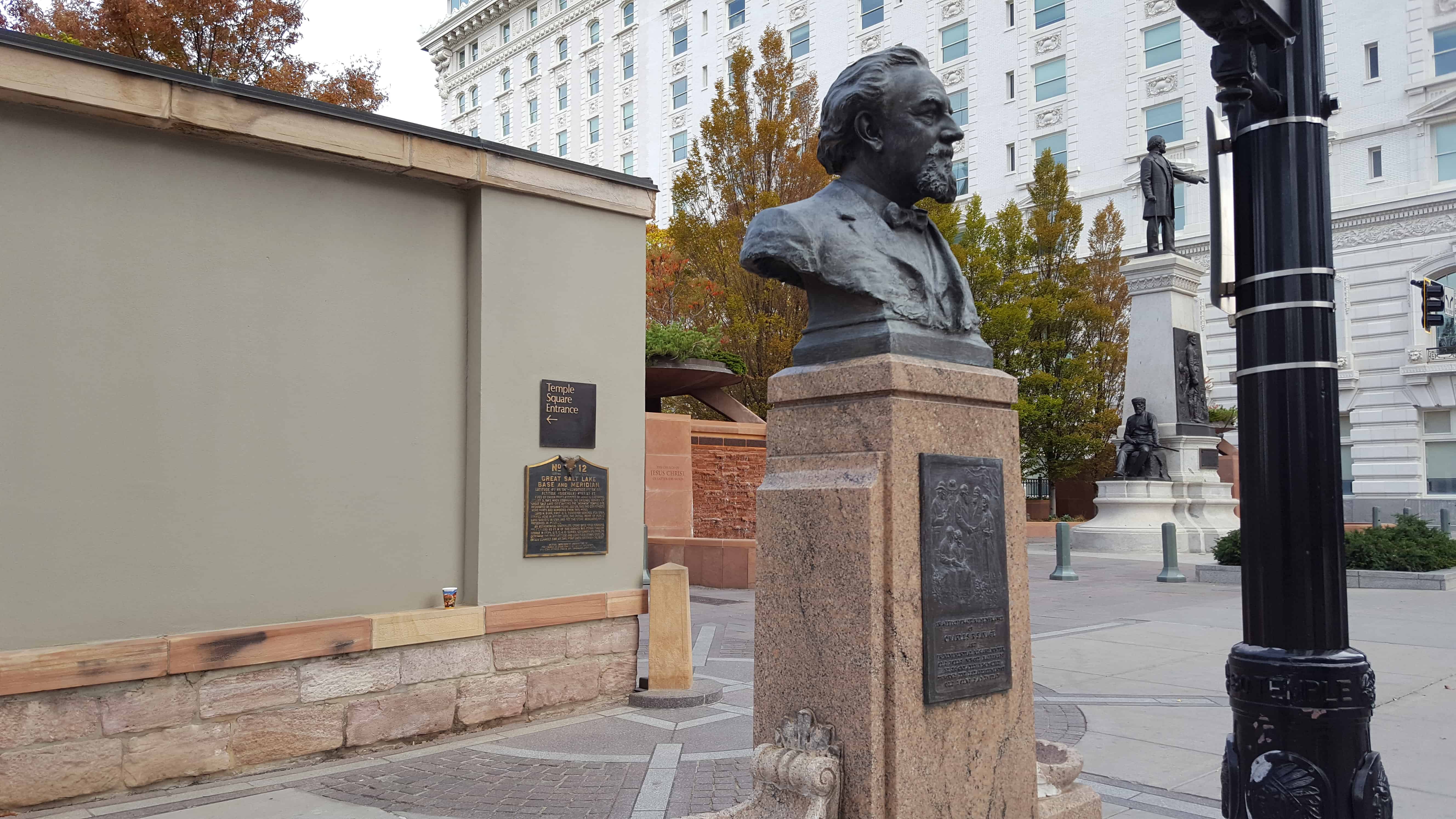
| UPTLA #12 | Great Salt Lake Base and Meridian | Salt Lake City, Salt Lake, Utah | Distant
Close up | N 40.76952 W 111.89134 |
| UPTLA #13 | Mormon Ferry | Casper, Natrona, Wyoming | | N 42.84474 W 106.37509 |
| UPTLA #14 | The First Statewide Pioneer Day Celebration | Brighton, Salt Lake, Utah | Distant
Close up | N 40.60357 W 111.58462 |
| UPTLA #15 | Eagle Rock Crossing | Idaho Falls, Bonneville, Idaho | | N 43.49235 W 112.04472 |
| UPTLA #16 | The Battle of Bear River | Preston, Franklin, Idaho | Distant
Close up | N 42.14080 W 111.91122 |
| UPTLA #17 | Mountain Meadow Massacre | Mountain Meadow, Washington, Utah | Distant
Close up | N 37.47554 W 113.64364 |
| UPTLA #18 | Sisters of the Holy Cross | Salt Lake City, Salt Lake, Utah | Distant
Close up | N 40.76736 W 111.86008 |
| UPTLA #19 | In Tribute to the Utah Pioneers | Salt Lake City, Salt Lake, Utah | Distant
Close up | N 40.77735 W 111.88747 |
| UPTLA #20 | The Social Hall | Salt Lake City, Salt Lake, Utah | Distant
Close up | N 40.76823 W 111.88807 |
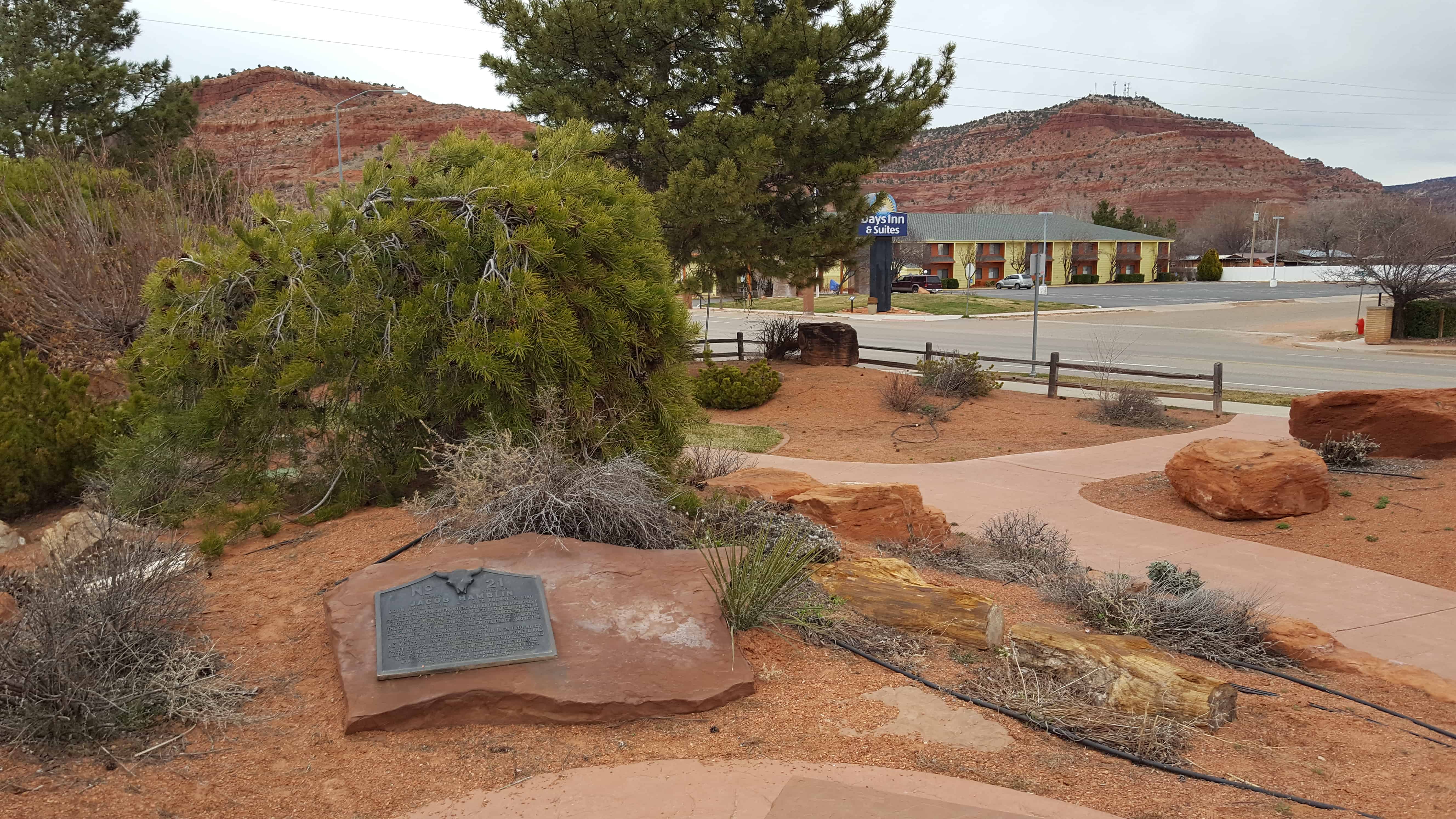
| UPTLA #21 | Jacob Hamblin | Kanab, Kane, Utah | Distant
Close up | N 37.04955 W 112.53532 |
| UPTLA #22 | Call’s Fort | Honeyville, Box Elder, Utah | Distant
Close up | N 41.60626 W 112.05877 |
| UPTLA #23 | Pioneer Square | Salt Lake City, Salt Lake, Utah | Distant
Close up | N 40.76231 W 111.90010 |
| UPTLA #24 & SUP 3 | Big Mountain | Little Emigration Canyon, Salt Lake, Utah | | N 40.82828 W 111.65414 |
| UPTLA #25 | The Mormon Wall | Fort Bridger, Uinta, Wyoming | Distant
Close up | N 41.31801 W 110.39316 |
| UPTLA #26 | Little Sandy Crossing | Farson, Sweetwater, Wyoming | Distant
Close up | N 42.10800 W 109.45326 |
| UPTLA #27 | Willie’s Handcart Company | Rock Creek, Fremont, Wyoming | | N 42.43869 W 108.62376 |
| UPTLA #28 & SUP U | Martin’s Cove | Martin’s Cove, Natrona, Wyoming | | N 42.43870 W 107.25972 |
| UPTLA #29 | Pipe Springs National Monument | Fredonia, Coconino, Arizona | Distant
Close up | N 36.94233 W 112.52607 |
| UPTLA #30 | The Old Iron Foundry | Cedar City, Iron, Utah | | N 37.68211 W 113.06111 |
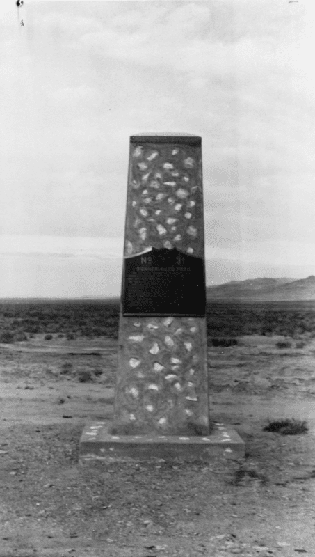
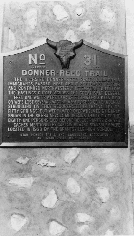
| UPTLA #31 | Donner Reed Trail | Grantsville, Tooele, Utah | Distant
Close up | West of Grantsville |
| UPTLA #32 | Fort Herriman | Herriman, Salt Lake, Utah | Distant
Close up | N 40.52073 W 112.03288 |
| UPTLA #33 | John C. Fremont | West Weber (Military Property), Weber, Utah | | N 41.25478 W 112.23875 |
| UPTLA #34 | Eagle Gate | Salt Lake City, Salt Lake, Utah | Distant
Close up | N 40.76956 W 111.88813 |
| UPTLA #35 | A Private School House | Salt Lake City, Salt Lake, Utah | Distant
Close up | N 40.76956 W 111.88813 |
| UPTLA #36 | Stage Coach Station | Layton, Davis, Utah | | N 41.05825 W 111.96539 |
| UPTLA #37 | Ephraim Hank’s Pony Express Station | Mountain Dell, Salt Lake, Utah | | N 40.78168 W 111.68329 |
| UPTLA #38 | Mormon Station - Genoa
| Genoa, Douglas, Nevada | | N 39.00424 W 119.84579
|
| UPTLA #39 | Jordan Narrows | Camp Williams, Salt Lake, Utah | Distant
Close up | N 40.43457 W 111.92222 |
| UPTLA #40 | Fort Henry | St. Anthony, Fremont, Idaho | | N 43.96453 W 111.68181 |
| UPTLA #41 | Miles Goodyear Cabin | Ogden, Weber, Utah | Distant
Close up
| N 41.22880 W 111.97559 |
| UPTLA #42 | Grantsville Fort | Grantsville, Tooele, Utah | Distant
Close up | N 40.60204 W 112.47342 |
| UPTLA #43 | Ensign Peak | Salt Lake, Salt Lake, Utah | Distant
Close up | N 40.79181 W 111.88824 |
| UPTLA #44 | Ogden Canyon Toll Gate | Ogden, Weber, Utah | Distant
Close up | N 41.23642 W 111.92899 |
| UPTLA #45 & SUP 177 | Lorin Farr | Ogden, Weber, Utah | Distant
Close up | N 41.22880 W 111.97559 |
| UPTLA #46 | Navajo County | Brigham City, Navajo, Arizona | | N 35.05301 W 110.70558 |
| UPTLA #47 | Deep Creek Station | Ibapah, Tooele, Utah | Distant
Close up | N 40.02974 W 113.98681 |
| UPTLA #48 | Rockwell Station | Draper, Salt Lake, Utah | Distant
Close up | N 40.48579 W 111.90532 |
| UPTLA #49 | Temple Granite Quarry | Sandy, Salt Lake, Utah | Distant
Close up | N 40.57158 W 111.77451 |
| UPTLA #50 | The Bee-Hive House | Salt Lake City, Salt Lake, Utah | Distant
Close up | N 40.76954 W 111.88859 |
| UPTLA #51 | The Lion House | Salt Lake City, Salt Lake, Utah | Distant
Close up | N 40.76954 W 111.88900 |
| UPTLA #52 | Brigham Young’s Office | Salt Lake City, Salt Lake, Utah | Distant
Close up | N 40.76953 W 111.88879 |
| UPTLA #53 & SUP W | Faust Station Pony Express | Faust, Tooele, Utah | Distant
Close up | N 40.17419 W 112.42745 |
| UPTLA #54 | In Honor of the Rexburg Stake Pioneers | Rexburg, Madison, Idaho | | N 43.82737 W 111.78405 |
| UPTLA #55 | The Great Fur Cache | Hyrum, Cache, Utah | Distant
Close up | N 41.63389 W 111.85598 |
| UPTLA #56 | Utah’s First Indian Battle | Pleasant Grove, Utah, Utah | Distant
Close up | N 40.36157 W 111.74054 |
| UPTLA #57 | Gardner’s Saw Mill | Salt Lake City, Salt Lake, Utah | Distant
Close up | N 40.69341 W 111.84857 |
| UPTLA #58 | The Mormon Colonists of the Big Horn Basin | Lovell, Big Horn, Wyoming | | N 44.84155 W 108.43954 |
| UPTLA #59 | Fort Harmony | New Harmony, Washington, Utah | Distant
Close up | N 37.48050 W 113.24323 |
| UPTLA #60 | Old Irontown | Old Irontown, Iron, Utah | Distant
Close up | N 37.59962 W 113.44940 |
| UPTLA #61 | Paragonah Fort | Paragonah, Iron, Utah | Distant
Close up | N 37.88681 W 112.77526 |
| UPTLA #62 | Pioneer Sundial | Parowan, Iron, Utah | Distant
Close up | N 37.84038 W 112.82770 |
| UPTLA #63 | First Community Center
| Logan, Cache, Utah | Distant
Close up
| N 41.74028 W 111.82432 |
| UPTLA #64 & SUP 138 & SUP K | Pioneer Flour Mill Site | Holladay, Salt Lake, Utah | Distant
Close up | N 40.69662 W 111.81517 |
| UPTLA #65 | Old Folks Day | Salt Lake City, Salt Lake, Utah | Distant
Close up | N 40.76951 W 111.89134 |
| UPTLA #66 | Wallsburg Fort | Wallsburg, Wasatch, Utah | Distant
Close up | N 40.38627 W 111.42257 |
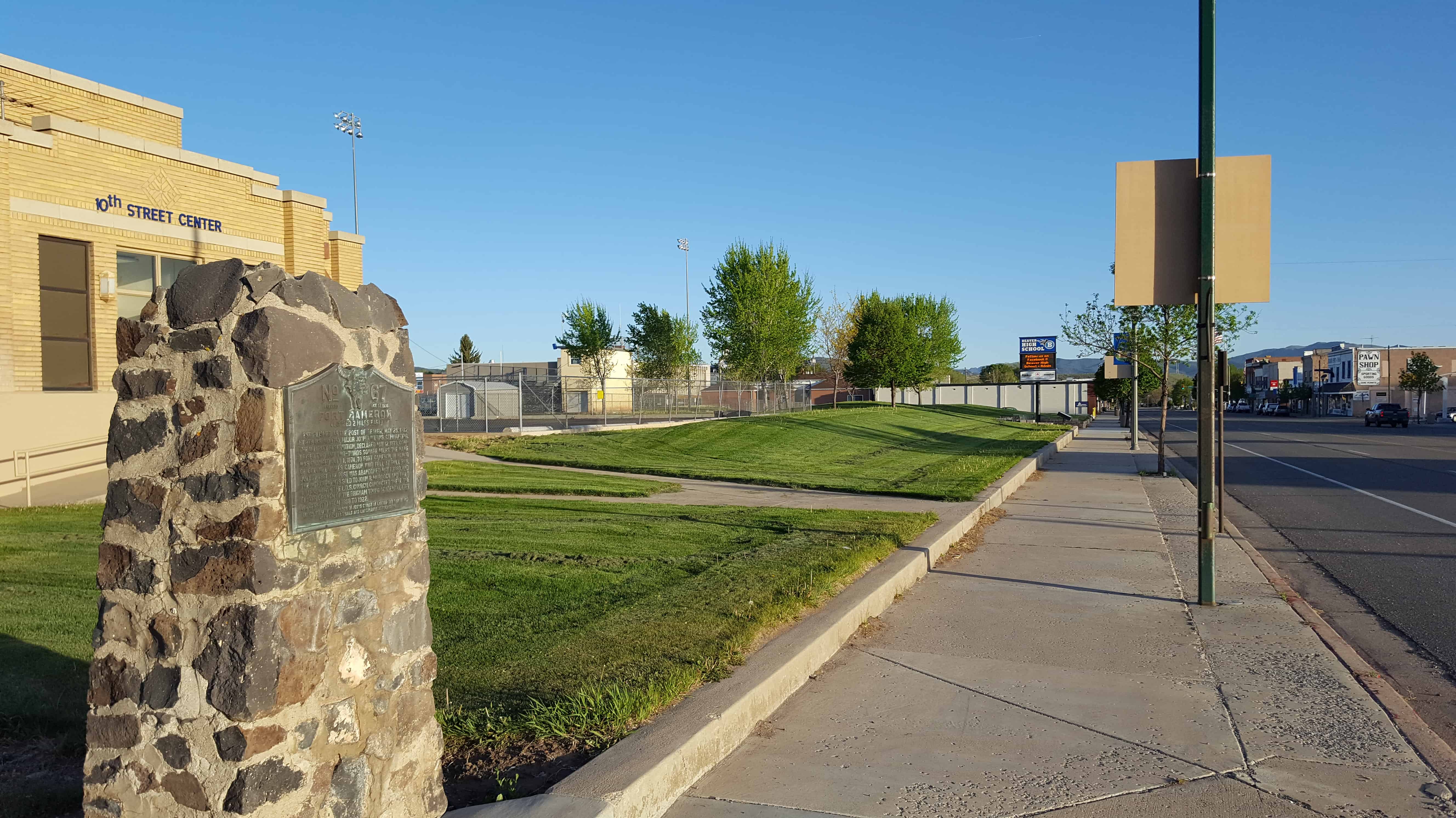
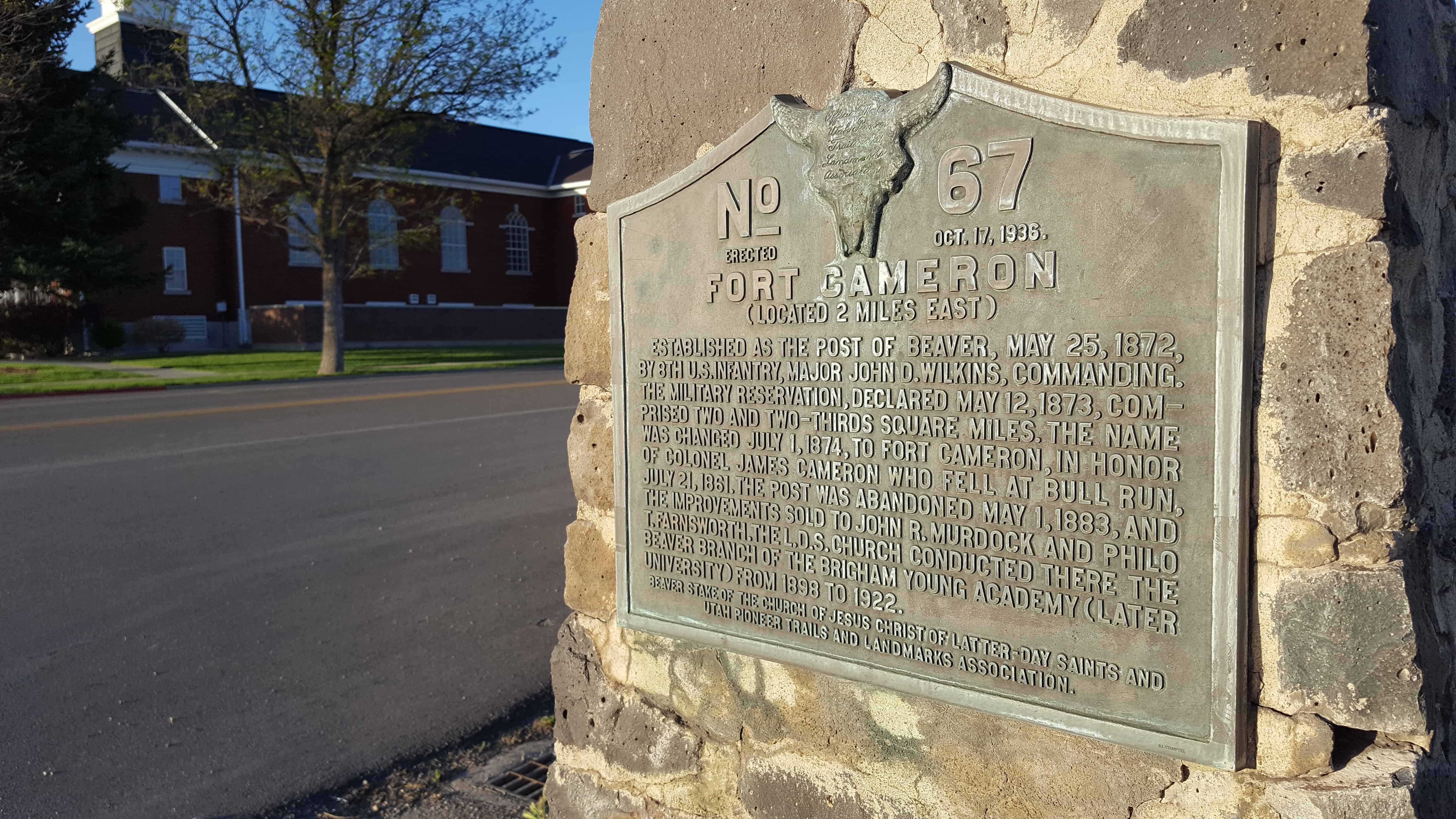
| UPTLA #67 | Fort Cameron | Beaver, Beaver, Utah | Distant
Close up | N 38.27677 W 112.64111 |
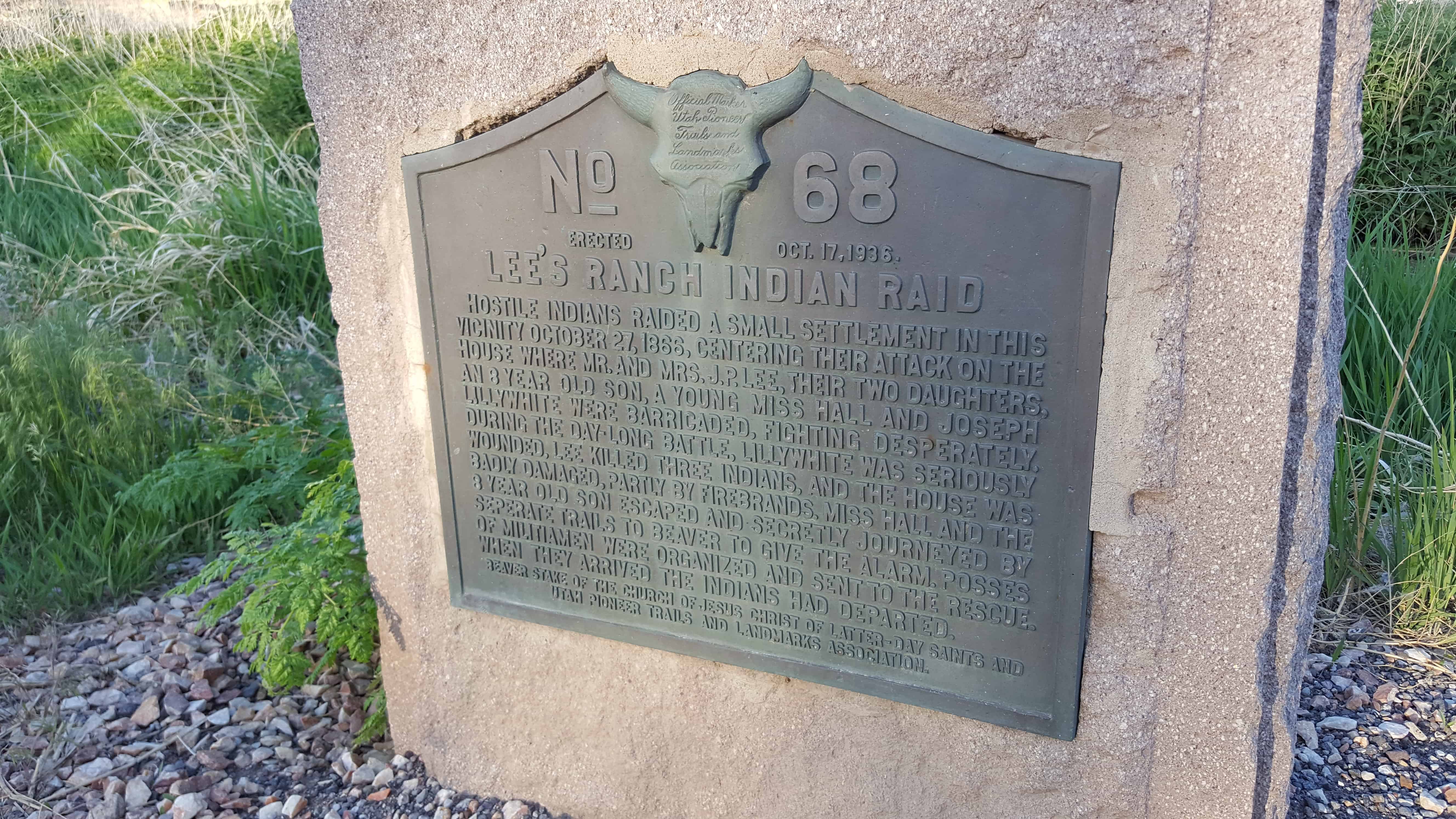
| UPTLA #68 | Lee’s Ranch Indian Raid | Brigham City, Box Elder, Utah | Distant
Close up | N 38.25363 W 112.64623 |
| UPTLA #69 | Brigham Young’s Last Public Address | Brigham City, Box Elder, Utah | Distant
Close up | N 41.51082 W 112.01953 |
| UPTLA #70 | Honor of The Mormon Pioneers of Idaho – Builders of North Fork (Snake
River) Ferry | Burton, Madison, Idaho | | N 43.82551 W 111.90577 |
| UPTLA #71 | Mormon Battalion Trail | Picacho, Pinal, Arizona | | N 32.64647 W 111.39455 ?? |
| UPTLA #72 | Pierre – Jean De Smet | Ogden, Weber, Utah | Distant
Close up | N 41.222476 W 111.964541 |
| UPTLA #73 | Charles Coulson Rich | Paris, Bear Lake, Idaho | | N 42.22552 W 111.40031 |
| UPTLA #74 | Fur Traders Rendezvous | Laketown, Rich, Utah | | N 41.85714 W 111.36363 |
| UPTLA #75 | Fort Robidoux | Fort Duchesne, Uintah, Utah | Distant
Close up | N 40.30168 W 109.89240 |
| UPTLA #76 | Great Salt Lake | Saltair, Salt Lake, Utah | | (missing?) |
| UPTLA #77 | Tonalea | Tonalea, Coconino, Arizona | | N 36.32577 W 110.93537 |
| UPTLA #78 | Grave of Brigham Young | Salt Lake City, Salt Lake, Utah | Distant
Close up | N 40.77011 W 111.88558 |
| UPTLA #79 | Pioneer Camp | Bridgeport, Morrill, Nebraska | | N 41.67968 W 103.09611 |
| UPTLA #80 | Pioneer Camp | North Platte, Lincoln, Nebraska | | N 41.16054 W 100.79100 |
| UPTLA #81 | Hole-in-the-Rock Crossing | Hole-in-the-Rock, Kane, Utah | | N 37.25643 W 110.90030 |
| UPTLA #82 | Fairfield – Camp Floyd – Fort Crittenden | Fairfield, Utah, Utah | | N 40.26050 W 112.09284 |
| UPTLA #83 | Willow Spring Pony Express Station | Callao, Juab, Utah | Distant
Close up | N 39.90027 W 113.71421 |
| UPTLA #84 | Hyde Park Settlers | Hyde Park, Cache, Utah | Distant
Close up | N 41.79933 W 111.82467 |
| UPTLA #85 | Tom Polaca | Snowflake, Navajo, Arizona | | N 35.89058 W 110.34834 |
| UPTLA #86 & SUP 2 | Lookout Station | Vernon, Tooele, Utah | Distant
Close up | N 40.11968 W 112.57649 |
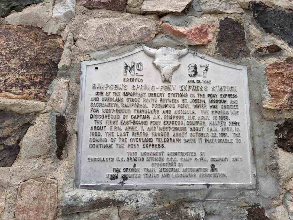
| UPTLA #87 | Simpson Spring – Pony Express Station | Simpson Springs, Tooele, Utah | Distant
Close up | N 40.03946 W 112.78756 |
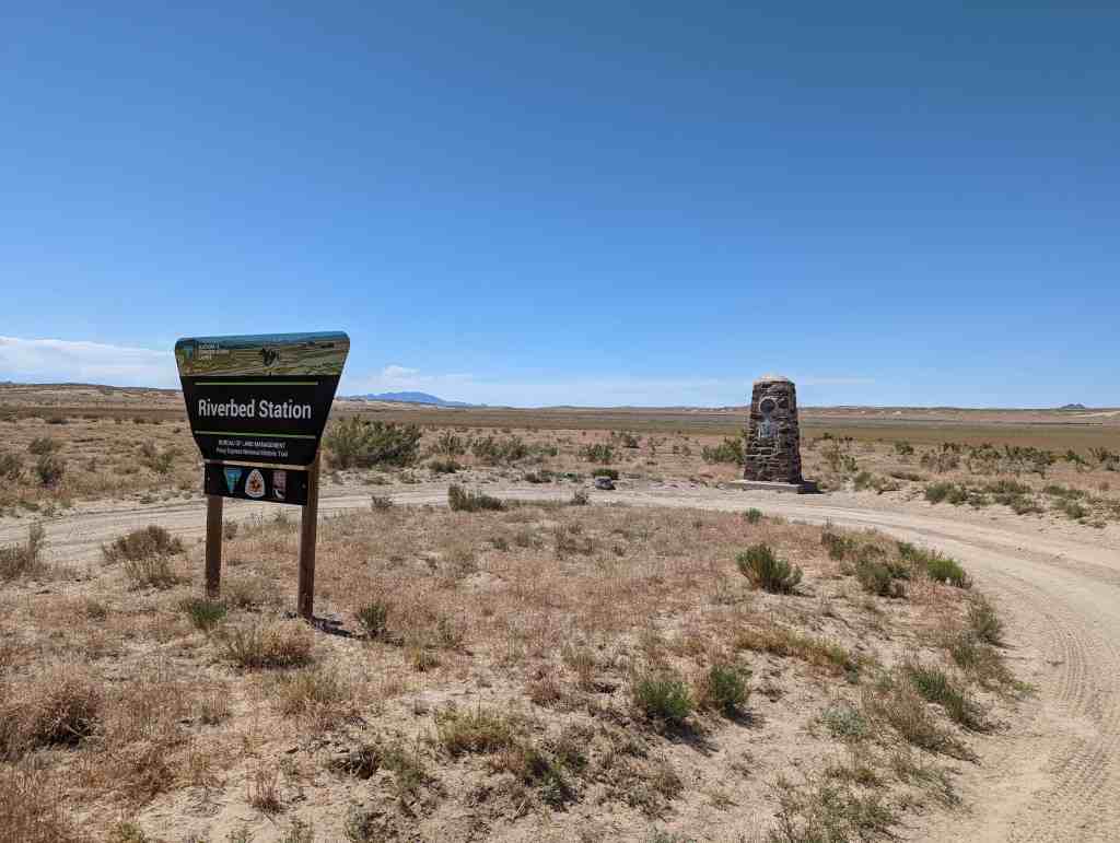
| UPTLA #88 | Riverbed Station | Simpson Springs, Tooele, Utah | Distant
Close up | N 39.95990 W 112.89508 |
| UPTLA #89 | Dugway Station | Dugway Station, Juab, Utah | | N 39.85797 W 113.03615 |
| UPTLA #90 | Blackrock Station | Blackrock Station, Juab, Utah | Distant
Close up | N 39.87807 W 113.27152 |
| UPTLA #91 | Fish Springs Station | Fish Springs, Juab, Utah | Distant
Close up | N 39.84803 W 113.41084 |
| UPTLA #92 | Boyd Station (marker missing) | Boyd Station, Juab, Utah | Distant
Close up | N 39.84375 W 113.55373 |
| UPTLA #93 | Round (Canyon) Pony Express Station | Callao, Tooele, Utah | | N 40.04450 W 113.80420 |
| UPTLA #94 | Burnt Station | Ibapah, Tooele, Utah | Distant
Close up | N 40.07680 W 113.84556 |
| UPTLA #95 | Burial Plot | Vernon, Tooele, Utah | Distant
Close up | N 40.11865 W 112.57768 |
| UPTLA #96 | Tuba, Hopi Chief | Tuba City, Coconino, Arizona | | N 36.13341 W 111.24040 |
| UPTLA #97 | Steptoe's Military Camp, Godbe's Smelter | Tooele, Tooele, Utah | Distant
Close up | N 40.42374 W 112.38182 |
| UPTLA #98 | Rush Valley Station | Rush Valley, Tooele, Utah | Distant
Close up | N 40.20646 W 112.29321 |
| UPTLA #99 | Mormon Battalion Route | Algodones, Sandoval, New Mexico | | N 35.45164 W 106.35390 |
| UPTLA #100 | This is the Place State Park | Salt Lake City, Salt Lake, Utah | | N 40.75222 W 111.81619
This is the Place Heritage Park |
| UPTLA #108 | Nauvoo Road | Alvinson, Ontario, Canada | | N 42.82116 W 81.86998 |
| UPTLA #109 | Union Fort | Midvale, Salt Lake, Utah | Distant
Close up | N 40.62112 W 111.85891 |
| UPTLA #110 | Providence Pioneers | Providence, Cache, Utah | Distant
Close up | N 41.70778 W 111.81751 |
| UPTLA #112 | Captain James Brown | Ogden, Weber, Utah | Distant
Close up | N 41.22028 W 111.97125 |
| UPTLA #113 | Lorin Farr | Ogden, Weber, Utah | Distant
Close up | N 41.22028 W 111.97125 |
| UPTLA #114 | Bingham Canyon | Bingham Canyon, Salt Lake, Utah | | Kennecott Copper Pit Visitor’s Center |
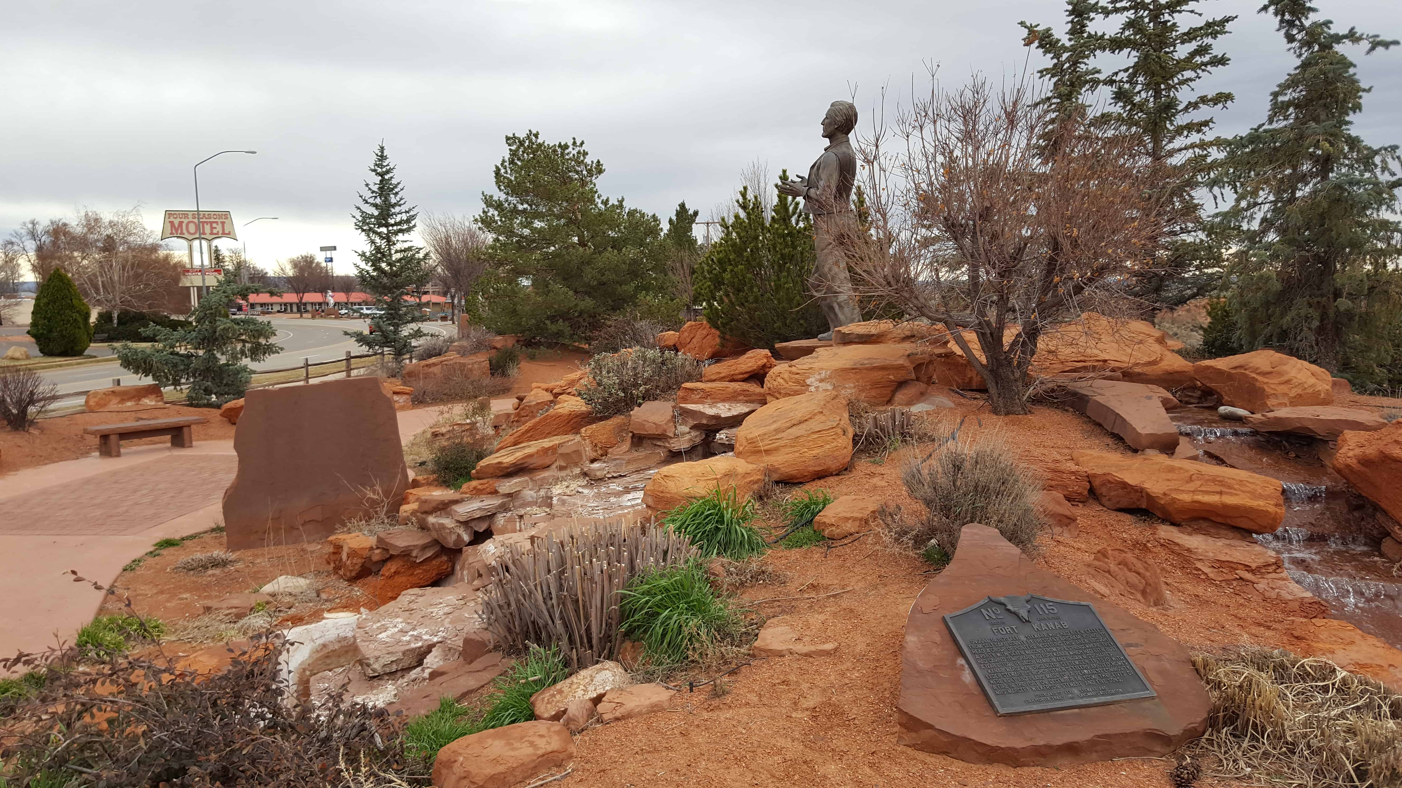
| UPTLA #115 | Fort Kanab | Kanab, Kane, Utah | Distant
Close up | N 37.04951 W 112.53530 |
| UPTLA #116 | The Salmon River Mission - Fort Lemhi | Tendoy, Lemhi, Idaho | | N 44.98346 W 113.63998 |
| UPTLA #117 | Mormon Pioneer Trail | Fremont, Dodge, Nebraska | | N 41.43524 W 96.49051 |
| UPTLA #118 & SUP A | Pioneers of Lehi | Lehi, Utah, Utah | Distant
Close up | N 40.37229 W 111.88449 |
| UPTLA #119 | Captain Jefferson Hunt | Downey, Bannock, Idaho | Distant
Close up | N 42.35453 W 112.04905 |
| UPTLA #120 | Weld the Past to the Present to Enrich the Future | Ogden, Weber, Utah | Distant
Close up | N 41.22077 W 111.97971 |
| UPTLA #130 | Mormon Pioneer Memorial Bridge | Florence, Douglas, Nebraska | | N 41.33740 W 95.96088 |
| UPTLA #131 | Mormon Pioneer Memorial Bridge | Crescent, Pottawattamie, Illinois | | N 41.34590 W 95.95562 |
| UPTLA #131 | The George Albert Smith Arch | Bluff, San Juan, Utah | | N 38.10516 W 109.76808 |
| UPTLA #132 | Hole-in-the-Rock Arch | Hole-in-the-Rock, Kane, Utah | | N 37.25755 W 110.95983 |
| UPTLA #133 | Old Pleasant Grove Fort | Pleasant Grove, Utah, Utah | Distant
Close up | N 40.36017 W 111.73589 |
| A & UPTLA 118 | Pioneers of Lehi | Lehi, Utah, Utah | Distant
Close up | N 40.37229 W 111.88449 |
| A-1 | Mormon Emigrant Trail | Squaw Valley, Placer, California | | |
| B | Golden Spike – Joining of the Rails | Promontory, Box Elder, Utah | | |
| B-1 | Old Fort Site | Holladay, Salt Lake, Utah | Distant
Close up | N 40.66775 W 111.82849 |
| C | Hampton’s Bear River Crossing | Collinston, Box Elder, Utah | Distant
Close up | N 41.78634 W 112.10618 |
| C-1 | Nauvoo Flag Pole | Nauvoo, Hancock, Illinois | | |
| D | Pioneer Telegraph Office | Salt Lake City, Salt Lake, Utah | Distant
Close up | N 40.76758 W 111.89094 |
| D-1 | First Latter-day Saint Chapel in Phoenix | Phoenix, Maricopa, Arizona | Distant
Close up | N 33.45013 W 112.06554 |
| E | Abraham Lincoln, Frontiersman | New Salem, Pike, Illinois | | |
| E-1 | Pioneer Industry in Parleys Canyon | Salt Lake City, Salt Lake, Utah | Distant
Close up | N 40.70849 W 111.80177 |
| F | Daniel C. Jackling | Salt Lake City, Salt Lake, Uta | | Utah State Capitol |
| F-1 | Spencer W. Kimball Home | Safford, Graham, Arizona | | |
| G | Lycurgus, Spartan Lawgiver, 9th century BC | Sparta, Central Square, Greece | | N 37.07321 E 22.42490 |
| G-1 | Logan Temple Marker | Logan, Cache, Utah | | (Missing?) |
| H | Captain Jefferson Hunt | Huntsville, Weber, Utah | | N 41.26036 W 111.77011
200 S 7400 E |
| H-1 | Mormon Flat | Emigration Canyon, Morgan, Utah | | N 40.82755 W 111.58335
(missing) |
| I | Brigham Young Bust | Salt Lake City, Salt Lake, Utah | | Utah State Capitol |
| I-1 | First Company of Pioneers into the Valley | Salt Lake City, Salt Lake, Utah | | N 40.75227 W 111.81609
(This is the place) |
| I-1 | Indian Trails Monument | North Ogden Canyon, Weber, Utah | | N 41.32043 W 111.89876 |
| J-1 | Union Pioneer Cemetery | Sandy, Salt Lake, Utah | Photo | N 40.60959 W 111.84880 |
| K & 138 & UPTLA 64 | Pioneer Flour Mill Site | Holladay, Salt Lake, Utah | Distant
Close up | N 40.69662 W 111.81517 |
| K-1 | Orem Shortline Railroad | Orem, Utah, Utah | | |
| K-2 | Early Bennion History | Taylorsville, Salt Lake, Utah | | |
| K-3 | Route of Johnston’s Army | Taylorsville, Salt Lake, Utah | | |
| K-4 | Birch Springs | Emigration Canyon, Salt Lake, Utah | | N 40.81077 W 111.67941 |
| L | The San Juan Mission | Bluff, San Juan, Utah | Distant
Close up | N 37.28708 W 109.54719 |
| M | Ira Merrill | Smithfield, Cache, Utah | Distant
Close up | N 41.83687 W 111.83293 |
| N & P | 10 ton Granite Block Honoring the Builders of the Salt Lake Temple | Farmington, Davis, Utah | | Lagoon |
| O | Dance Hall Rock | Escalante, Kane, Utah | | Hole in the rock road |
| P & N | Pioneer Village: Original Vanguard Company | Farmington, Davis, Utah | | Lagoon |
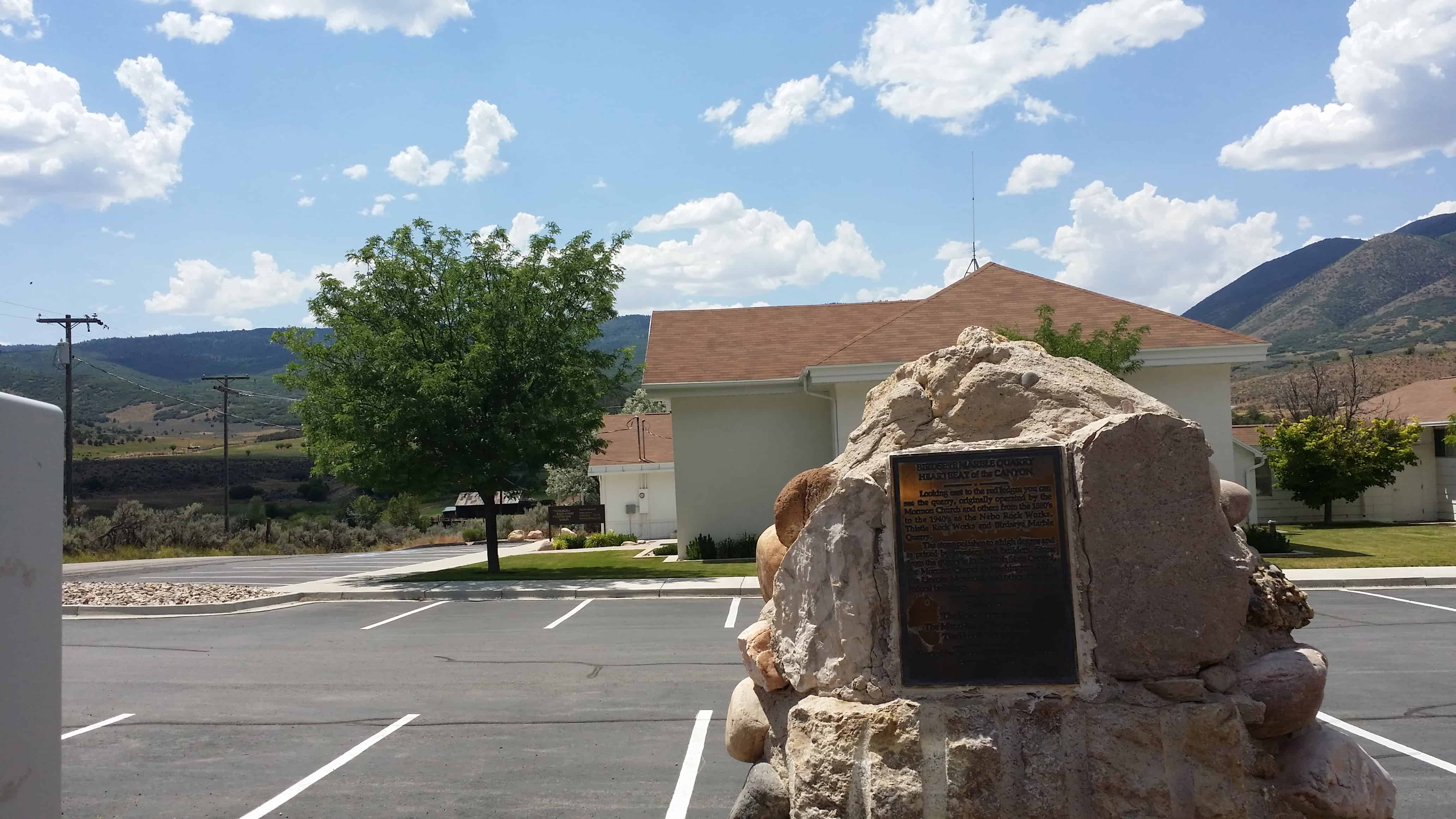
| P-1 | Birdseye Marble Quarry | Birdseye, Utah, Utah | Distant
Close up | N 39.92451 W 111.54450 |
| Q | Col. Philip St. George Cooke | Fairfield, Utah, Utah | Distant
Close up | N 40.26048 W 112.09308 |
| Q-1 | Pioneer Cemetery | Taylorsville, Salt Lake, Utah | | 4575 S. Jordan River Parkway |
| R | Fountain | Huntsville, Weber, Utah | | N 41.26036 W 111.77011
200 S 7400 E |
| R-1 | Pioneer Cemetery | Spanish Fork, Utah, Utah | | |
| S | First Camp of the Pioneers | Sycamore Valley Ranch, San Bernardino, California | | |
| S-1 | Sugar House Monument | Sugar House, Salt Lake, Utah | Distant
Close up | N 40.72531 W 111.86018 |
| T | Sagwitch Timbimboo, Shoshone Chief | Washakie, Box Elder, Utah | | N 41.94571 W 112.23417 |
| U & UPTLA 28 | Martin’s Cove | Martin’s Cove, Natrona, Wyoming | | |
| V | The 500 Volunteer Soldiers of the Mormon Battalion 1846 – 1848 | San Diego, San Diego, California | | N 32.75736 W 117.19408 |
| W & UPTLA 53 | Faust Station Pony Express | Faust, Tooele, Utah | Distant
Close up | N 40.17419 W 112.42745 |
| X | John C. Freemont Memorial | Parowan, Iron, Utah | Distant
Close up | N 37.84012 W 112.82776 |
| Y | Lehi Chapel | Lehi, Utah, Utah | | 200 West 200 South |
| Z | Brigham Young Grave Statue ("All is Well”) | Salt Lake City, Salt Lake, Utah | Photo | N 40.77011 W 111.88558 |
| | | | |


