Charles Shreeve Peterson – Helped carve road through Weber Canyon. 1st Probate Judge.
George Washington Taggart – Helped build 1st grist mill. Mormon Battalion member.
Thomas Jefferson Thurston – Builder of roads and canals. 1st Bishop in valley.
Sanford Porter – Original settler of Porterville. Built sawmill, cut ties for railroad.
Thomas and Jane Brough – Church leadership and community service.
Jesse Carter Little – Military-Civic-Church leader, road builder, 1st Post Office.
Willard G. Smith – Community builder, 1st Stake President & Probate Judge, Haun’s Mill survivor, Mormon Battalion member.
Samuel and Esther Francis – Leaders in church and civic affairs.
Albert Douglas Dickson – Peacemaker, canal builder, bishop for 37 years.
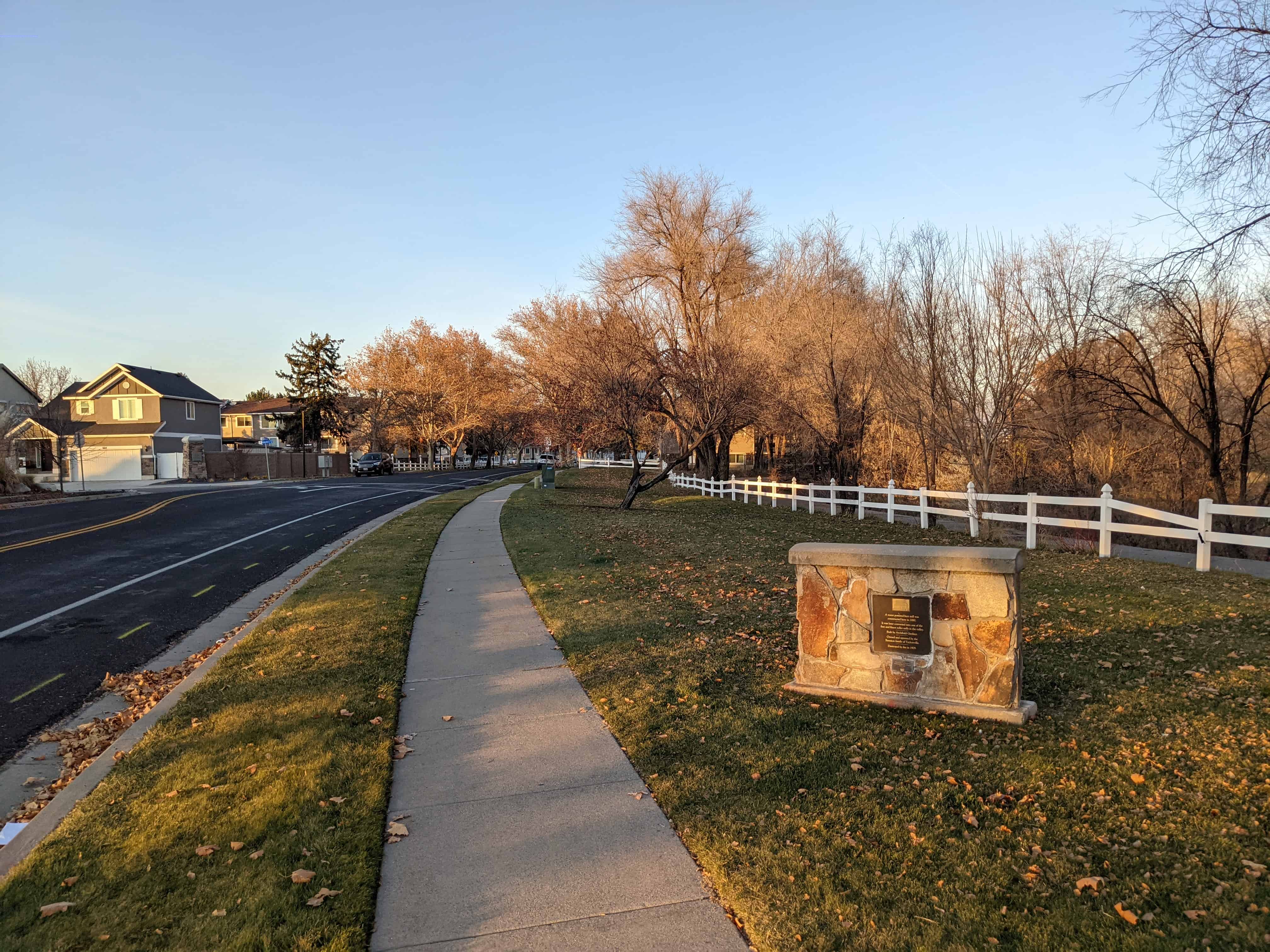
Located at 221 East 125 North in Morgan, Utah – this is Sons of Utah Pioneers historic marker #155 placed in 2010 with a new name added every year for a few years.
In the year 1854 or 1855 the settlers built a mud wall most of the way around the town. The wall began at the corner of West Street and Vine Street intersection and then south to the south side of Locust Street (1st South) then east to the east side of 1st East Street then north to the north side of Green Street (1st North) then west to a point about twenty rods east of Main Street where it ended.
The Mud Wall was built to help protect the settlers from Indian attacks. The attacks never came, due in part to the counsel given by Brigham Young, to feed the Indians, rather than fight them.
The only thing that the Mud Wall was used for was that a number of wolves were shot from the wall at the south west corner.
We call the attention of the reader to the laborious work of building the Mud Wall. Food was scarce at that time. They had many hardships to contend with in their poverty, with houses to build, fencing materials to get out of the canyons, roads and irrigation canals to build and Indians to guard against. It should also be remembered that the tools they had to work with were crude and inferior.
Building the mud wall
The work of building the Mud Wall was done by taxing every able body man to do his share. The wall was 2 ½ feet wide at the base, 1 foot wide at the top, 9 feet high and each section was 16 feet long.
Water was flooded over the ground each night and a strip on both sides of the wall was ploughed to soften the mud. Planks were then set on edge and held together by long 1 ¾ inch round pins secured by wooden keys.
The wet soil was then shoveled between the planks from both sides with one man tamping the soil. A young boy spread straw into the mud so that it would be less likely to crack as it dried.
When the first pair of planks were filled and thoroughly tamped, the next pair was put in place until the top was reached.
When the mud dried the planks were removed and another section built as before so that the wall was built by section.
Note: The replica is one-half size of the original wall built 2 ½ feet wide at the base, 1 foot wide at the top, 9 feet high and built in 16 foot sections.
Sons of Utah Pioneers historic marker #147, located at 100 West Vine Street on the Library grounds in Tooele, Utah
In 1855, upon the counsel of Brigham Young, Joseph Harker, with John and Samuel Bennion, hand-dug the lower ditch to irrigate the farmland on the river bottoms west of the Jordan River.
A small rock dam was constructed on the Jordan River at about 6300 South. Water was taken from the river at that pointand came north to the park site. The ditch skirted the west and north boundaries of the park and then north to the mill.
In 1880, a new grist mill was constructed on the Jordan River near 4800 South. Water was taken from the Lower Ditch to power the mill and the name MILLRACE was applied to the ditch.
Sons of Utah Pioneers historic marker #117 erected in 2005 by the Taylorsville Bennion Sons of Utah Pioneers, it is located in Millrace Park at 1200 West 5400 South in Taylorsville, Utah
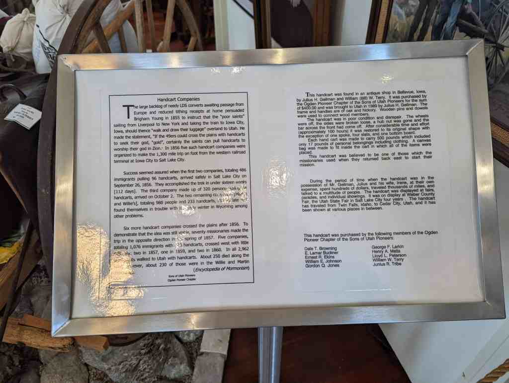
This handcart was found in an antique shop in Bellevue, lowa, by Julius H. Geilman and William (Bill) W. Terry. It was purchased by the Ogden Pioneer Chapter of the Sons of Utah Pioneers for the sum of $400.00 and was brought to Utah in 1989 by Julius H. Geilman. The frame and handles are of oak and hickory. Wooden pins and dowels were used to connect wood members.
The handcart was in poor condition and disrepair. The wheels were off, the sides were broken loose, a hub nut was gone and the bar across the front had come off. After considerable time and effort (approximately 100 hours) it was restored to its original shape with the exception of one spoke, four slats, and one bottom board.
Each hand cart was made to carry 500 pounds which included only 17 pounds of personal belongings including clothing. A canvas bag was made to fit inside the cart in which all of the items were placed.
This handcart was believed to be one of those which the missionaries used when they returned back east to start their mission.
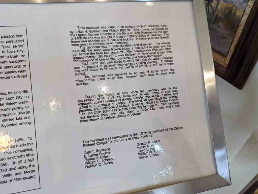
During the period of time when the handcart was in the possession of Mr. Geilman, Julius and his wife, Irene, at their own expense, spent hundreds of dollars, traveled thousands of miles, and talked to a multitude of people. The handcart was displayed at fairs, parades, and individual showings. It was on display at Weber County Fair, the Utah State Fair in Salt Lake City four years. The handcart has traveled from Twin Falls, Idaho, to Cedar City, Utah, and it has been shown at various places in between.
This handcart was purchased by the following members of the Ogden Pioneer Chapter of the Sons of Utah Pioneers: Dale T. Browning, E. Lamar Buckner, Ernest R. Ekins, William E. Johnson, Gordon Q. Jones, George F. Larki, n Henry A. Matis, Lloyd L. Peterson, William W. Terry, Junius R. Tribe.
The large backlog of needy LDS converts awaiting passage from Europe and reduced tithing receipts at home persuaded Brigham Young in 1855 to instruct that the “poor saints” sailing from Liverpool to New York and taking the train to Iowa City, Iowa, should thence “walk and draw their luggage” overland to Utah. He made the statement, “If the 49ers could cross the plains with handcarts to seek their god, “gold”, certainly the saints can pull handcarts to worship their god in Zion.” In 1856 five such handcart companies were organized to make the 1,300 mile trip on foot from the western railroad terminal at Iowa City to Salt Lake City.
Success seemed assured when the first two companies, totaling 486 immigrants pulling 96 handcarts, arrived safely in Salt Lake City on September 26, 1856. They accomplished the trek in under sixteen weeks [112 days]. The third company made up of 320 persons pulling 64 handcarts, arrived on October 2. The two remaining companies [Martin and Willie’s], totaling 980 people and 233 handcarts, started late and found themselves in trouble with the early winter in Wyoming among other problems.
Six more handcart companies crossed the plains after 1856. To demonstrate that the idea was still viable, seventy missionaries made the trip in the opposite direction in spring of 1857. Five companies, totaling 1,076 immigrants with 223 handcarts, crossed west with little difficulty: two in 1857, one in 1859, and two in 1860. In all 2,962 immigrants walked to Utah with handcarts. About 250 died along the way, about 230 of those were in the Willie and Martin companies.
One of the important desert stations on the Pony Express and Overland Stage route between St. Joseph, Missouri and Sacramento, California. From this point, water was carried for for west-bound travelers and animals. The spring was discovered by Captain J. H. Simpson, U. S. Army, in 1858.
The first east-bound Pony Express courier, halted here about 5p.m. April 7, and west-bound about 2a.m. April 10, 1860. The last riders passed about October 22, 1861. The coming of the Overland Telegraph made it inadvisable to continue the Pony Express.
This monument constructed by enrollees, U. S. Grazing Division, C. C. C. Camp G-154, Company 2517 on August 23, 1940 and sponsored by the Oregon Trail Memorial Association and the Utah Pioneer Trails and Landmarks Association (#87 of their monuments) it was later adopted by the Sons of Utah Pioneers.
The first known residents of the Riverton area were the Yo No Indians, a poor tribe living along the Jordan River. Well-worn trails extended from Utah Lake where various tribes wintered, to Bear Lake where they rendezvoused during the summer. Much credit is due for the free use of their byways, exchange of leather goods and furs, relinquishing land, and their general friendly attitude. Four forts erected west of the river were never seriously needed for protection. They were: Wight’s Fort, north by the Oquirrh Mountains; English Fort at the Bennion Cemetery site; Fort Herriman, 5 miles west of here; and Cedar Fort to the south.
Riverton was born of the Pioneer Spirit that moved men and women independently to reach out and wrestle a living from the harsh, untamed land. Many settlers spent their first year in dug-outs along the Jordan River as did the Yo No’s.
In 1855, Abraham Hunsaker, a convert from Illinois and a member of the Mormon Battalion, moved his herds across the river to join Jesse Beckstead and Samuel and Thomas Butterfield who were already using the land for grazing. Abraham was the first man to own land and divert water. But Archibald Gardner was the first to live here and become the largest land owner; so for many years the area was called “Gardnersville.” Judge Charles Smith later named the town “Riverton”.
From 1850 to 1881 most attempts to bring water to the land were inadequate, however, some succeeded. The fertile soil responded, and the permanent expanding settlement was here to stay. Sheep, cattle, alfalfa, beets, minerals, poultry, and dry farming all had their “hey day” and contributed greatly to the growing economy.
A maturity milestone was reached August 8, 1886, when the Riverton Ward of the Church of Jesus Christ of Latter-day Saints was organized with 138 members. Orrin P. Miller served as the first Bishop. Plans were soon underway for a new meeting house. Richard W. Kletting was selected as architect. (He was also architect of the Utah State Capitol and the old Saltair Pavillion). Willard C. Burgon was named building contractor. With visions of new hope, the people geared for Riverton’s “Grandest Effort.” Construction began in 1899.
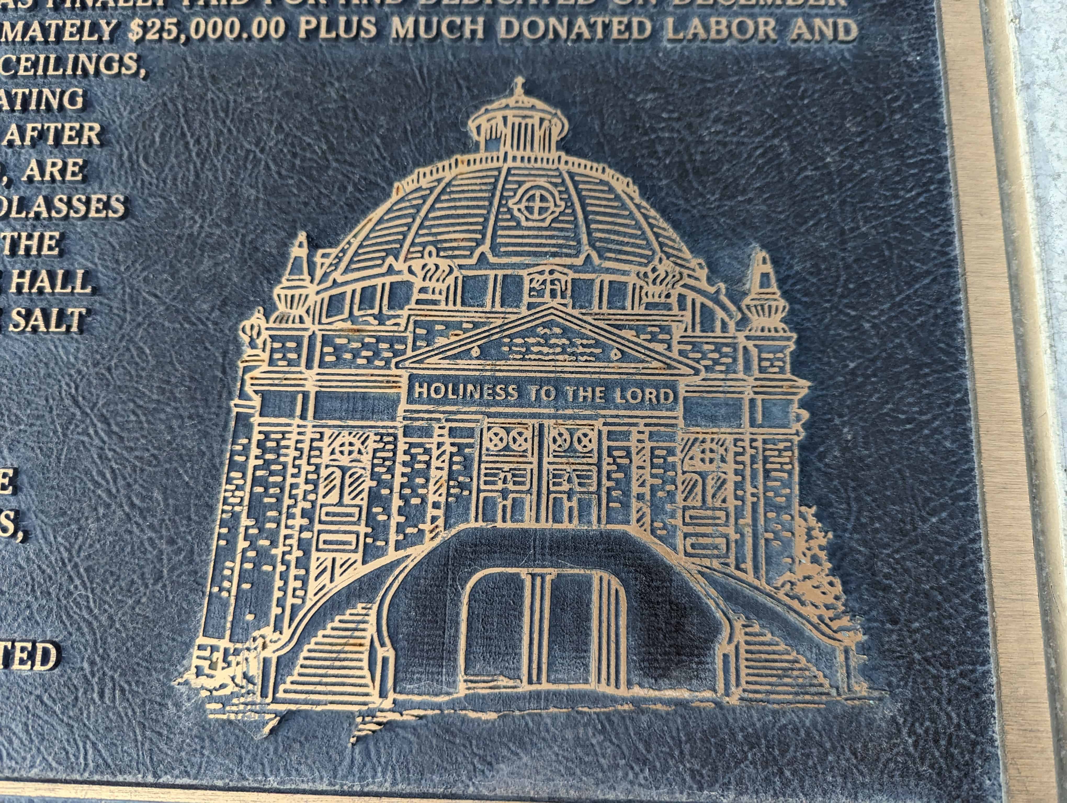
This magnificently beautiful domed church, with the inscription “HOLINESS TO THE LORD” over the front door was erected at 12800 South Redwood Road on a two-acre site donated by Thomas P. Page. With its high dome, it was an inspiring edifice and could be seen for long distances.
On January 21, 1900, Bishop Miller was sustained stake president, Gordon S. Bills was ordained bishop of the 346 member ward. The lower part of the building was in use by 1908. There were many financial hardships during construction, however, it was finally paid for and dedicated on December 20, 1920. The cost was approximately $25,000.00 plus much donated labor and materials. Because of its high ceilings, excessive maintenance and heating problems, it was razed in 1940 after just 30 years of use. Gone, too, are the brick kiln, Tithing Yard, molasses mill, flour mill, harness shop, the Commercial Building and dance hall built by Daniel Densley, and the Salt Lake and Utah Railroad (Orem Commuter Line) 1914-1945.
Many fond memories linger in the hearts of the long-time residents, the “Pioneers” of Riverton.
This monument is gratefully erected to their memory and integrity.
This marker honors the first settlers of Providence, who camped near here early in May 1859, and those who followed in the years 1860,1861,1862. Included in the groups who pioneered this section are the following families: Alder, Bowen, Busenbark, Baer, Campbell, Clifford, Clark, Cranney, Dee, Durfey, Fuhriman, Flemming, Fife, Gates, Gassman, Greenback, Hafter, Hansen, Harmon, Hoth, Hug, Hall, Kresie, Lau, Low, Lane, Loosle, Maddison, Sperry, Sueifel, Theurer, Traber, VanLouevan, Williams, Wright, Zollinger.
This historic marker was erected June 7, 1947 by the Utah Pioneer Trails and Landmarks Association and is #110 in the series, their markers were later adopted by the Sons of Utah Pioneers. It is located at the Providence Church at 10 South Main Street in Providence, Utah
This cabin, built about 1841 by Miles Goodyear, as far as known the first permanent house built in Utah, stood near the junction of the Ogden and Weber Rivers. In 1848 it was sold to Captain James Brown of the Mormon Battalion with a Spanish land grant covering all of Weber County. It was preserved by Minerva Stone Shaw and by her presented to the Daughters of the Utah Pioneers, Weber County Chapter, who placed it on its present site.
This is Utah Pioneers Trails and Landmarks Association historic marker #41, later adopted by the Sons of Utah Pioneers. Erected July 24, 1934 and located at the Weber County Daughters of Utah Pioneers Museum at 2104 Lincoln Avenue in Ogden, Utah