
The historic markers of the Salt Lake to Southern California Road series.
- SLSCR UT-1 – Point of Mountain – N 40.45151 W 111.91419
- SLSCR UT-2 – Fort Utah – N 40.23945 W 111.68921
- SLSCR UT-3 – Peteetneet – N 40.04095 W 111.73217
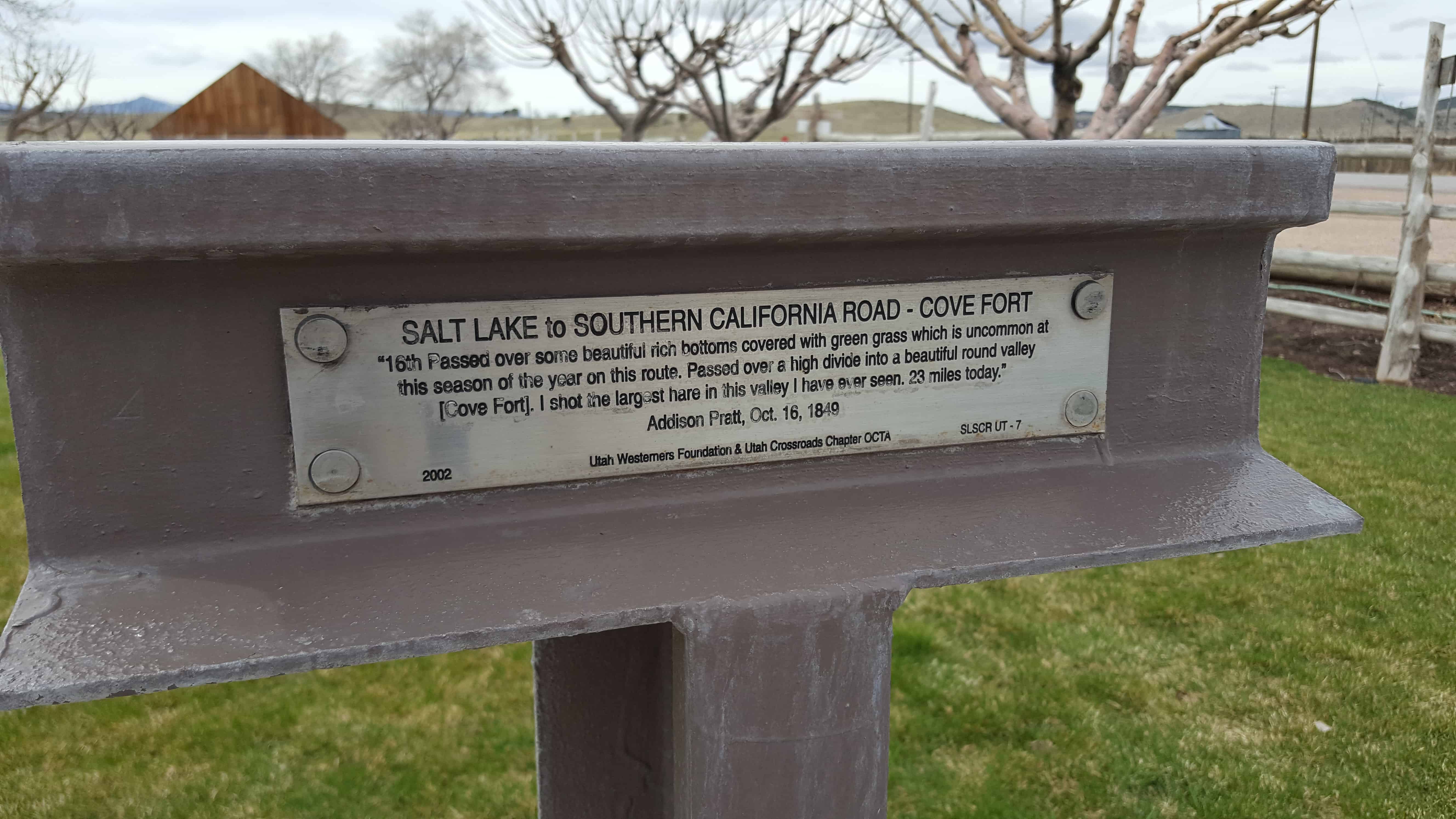
- SLSCR UT-7 – Cove Fort – N 38.60133 W 112.58059
- SLSCR BC-2 Burnett Cutoff – Muddy Water – N 41° 50.703 W 121° 18.606
- SLSCR L-3 – Lassen Trail – Conical Rocks – N 41° 33.931 W 120° 26.445
- SLSCR L-5 – Lassen Trail – Pit River Ford – N 41° 28.831 W 120° 32.525
- SLSCR L-10 – Lassen Trail – Foot Wear – N 41° 23.998 W 120° 56.090
- SLSCR L-11 – Lassen Trail – Pit River Canyon – N 41° 25.214 W 121° 00.356
The historic markers of the Hastings Cutoff series.
- H JM UT 1 – Hastings Cutoff – James Mathers – Weber Canyon Devils Gate – N 41.13901 W 111.84821
- HU-3.2 – Hastings Cutoff – The Hogsback – N 40.95391 W 111.54986
- HU-3A – Hastings Cutoff – Broad Hollow – N 40.93511 W 111.56748
- HU-3B – Hastings Cutoff – East Canyon Creek – N 40.91732 W 111.57993
- HU-3C – Hastings Cutoff – East Canyon Creek 4th Crossing – N 40.89724 W 111.58785
- HU-3D – Hastings Cutoff – Large Spring Camp – N 40.81945 W 111.58308
- HU-3E – Hastings Cutoff – Big Mountain Pass – N 40.82793 W 111.65445
- HU-5 – Hastings Cutoff – Utah Outlet (Jordan River) N 40.71209 W 111.92345
- HU-5A – Hastings Cutoff / Central Overland Trail – Deadman’s Cave – N 40.72184 W 112.15550
- HU-10A – Hastings Cutoff – Horseshoe Springs – N 40.61374 W 112.70805
- HU-11 – Hastings Cutoff – Horseshoe Springs – N 40.61391 W 112.70767
- HU-16 – Hastings Cutoff – West Side of Hastings Pass
The historic markers of the Central Overland Trail series.
- COTU-1 – Washington Square – N 40.76035 W 111.88786
- COTU-2 – Jordan River Bridge – N 40.77167 W 111.92581
- COTU-2A – Hastings Cutoff / Central Overland Trail – Deadman’s Cave – N 40.72184 W 112.15550
- CUTU-5 – Central Overland Trail – Rush Valley – N 40.45176 W 112.36270
- COTNU-2 – Five Mile Pass – N 40.23161 W 112.17858
- COTNU-3 – Lookout Pass – N 40.11479 W 112.56595
- COTNU-4A – Central Overland Trail – Skull Valley – N 40.08335 W 112.76367
- COTNU-7 – Central Overland Trail – Simpson Springs – N 40.03936 W 112.78722
- COTNU-7A – Old Riverbed Junction – N 39.96976 W 112.88786
- COTNU-8 – Dugway Pass – N 39.85216 W 113.08584
- COTNU-8A – Black Rock Hills Southern Route – N 39.87267 W 113.16283
- COTNU-10A – Fish Springs Mountain – N 39.89865 W 113.44693
- COTNU-12 – Boyd Station – N 39.84375 W 113.55373
- COTNU-13 – Willow Springs [Callao] – N 39.90027 W 113.71421
- COTNU-14 – Deep Creek Summit – N 40.09983 W 113.87909
The historic markers of the Hensley / Salt Lake Cutoff series.
- HSLC UT 1 – Hensley / Salt Lake Cutoff – Warm Springs – N 40.79020 W 111.90054
- HSLC UT 3-A – Hensley / Salt Lake Cutoff – Heavy Sand – N 41.18265 W 112.00960
The historic markers of the Jedediah Smith’s Trail series.
- JSTU-1 – Great Salt Lake – N 40.74664 W 112.18543
Trails West has a lot of info on these markers.
My page on the California Trail is here.
Pingback: SLC to SoCal – Cove Fort | JacobBarlow.com
Pingback: SLC to SoCal – Fort Utah | JacobBarlow.com
Pingback: Hastings Cutoff – Utah Outlet (Jordan River) | JacobBarlow.com
Pingback: Central Overland Trail – Washington Square | JacobBarlow.com
Pingback: Jedediah Smith’s Trail – Great Salt Lake | JacobBarlow.com
Pingback: Rush Valley Station | JacobBarlow.com