
SONS OF UTAH PIONEERS MARKERS
I started out collecting photos of all the D.U.P. Markers I could for and often saw S.U.P. Markers and U.P.T.L.A. Markers while doing it, so I decided to start collections for those as well. All Photos here are taken by me (Jacob Barlow.)
For decades, The Sons of Utah Pioneers have established historical monuments and markers throughout the western United States. These markers commemorate trails, events, buildings and persons of historical significance during the pioneer settling of the West. Additional markers were established by the Utah Pioneer Trails and Landmarks Association (no longer in existence), and these are now overseen by the Sons of Utah Pioneers.
| # | Marker Name | City, County, State | Photos | Exact Location |
|---|---|---|---|---|
| 1 | Murray Smelter Smoke Stacks | Murray, Salt Lake, Utah | Murray Park (Stacks were torn down in 2002) |
|
| 2 (Also UPTLA #86) | Lookout Station | Vernon, Tooele, Utah | Distant Close up | N 40.11968 W 112.57649 |
| 3 (Also UPTLA #24) | Big Mountain | Little Emigration Canyon, Salt Lake, Utah | Distant Close up | N 40.82793 W 111.65375 |
| 4 | The Golden Pass Road – Parley’s Canyon | Salt Lake City, Salt Lake, Utah | Distant Close up | N 40.70859 W 111.80188 |
| 4-A | Early Pioneer Mills | Salt Lake City, Salt Lake, Utah | Distant Close up | N 40.70859 W 111.80188 |
| 4-B | B&K Tannery | Salt Lake City, Salt Lake, Utah | Distant Close up | N 40.70859 W 111.80188 |
| 4-C | Ensign Peak | Salt Lake City, Salt Lake, Utah | Distant Close up | N 40.70857 W 111.80195 |
| 4-D | The Overland Stage | Salt Lake City, Salt Lake, Utah | Distant Close up | N 40.70857 W 111.80195 |
| 4-E | Willard Richards | Salt Lake City, Salt Lake, Utah | Distant Close up | N 40.70854 W 111.80200 |
| 4-F | Charles Stillman Bridge | Salt Lake City, Salt Lake, Utah | Distant Close up | N 40.70858 W 111.80190 |
| 4-G | Handcart Companies | Salt Lake City, Salt Lake, Utah | Distant Close up | N 40.70854 W 111.80200 |
| 4-H | Kanyon Creek Mill | Salt Lake City, Salt Lake, Utah | Distant Close up | N 40.70854 W 111.80200 |
| 4-I | Brighton | Salt Lake City, Salt Lake, Utah | Distant Close up | N 40.70854 W 111.80200 |
| 4-L | Horace A. Sorensen | Salt Lake City, Salt Lake, Utah | Distant Close up | N 40.70849 W 111.80184 |
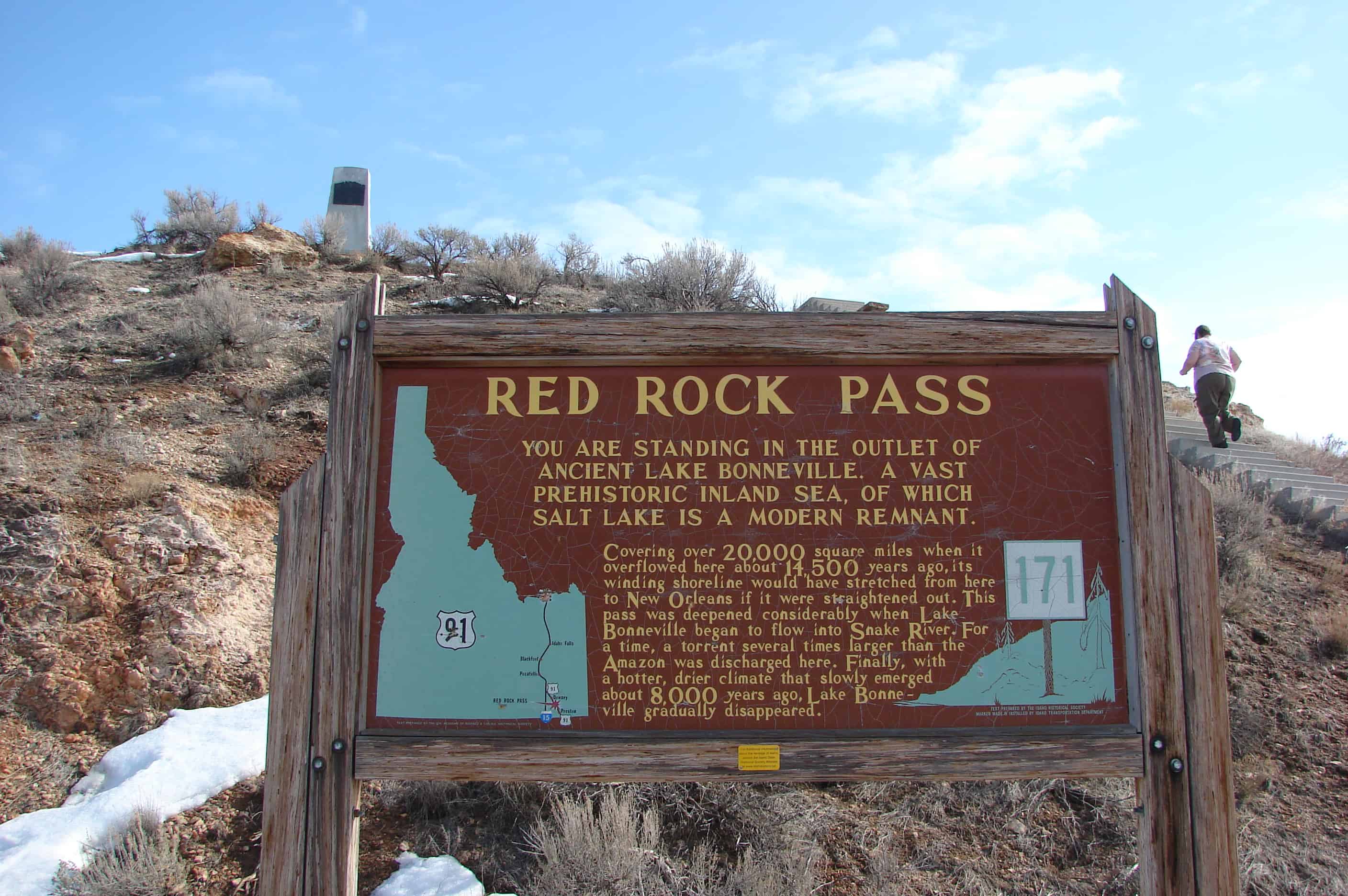
| 5 | Lorenzo Snow Burial Site | Brigham City, Box Elder, Utah | Distant Close up | N 41.50262 W 112.00985 |
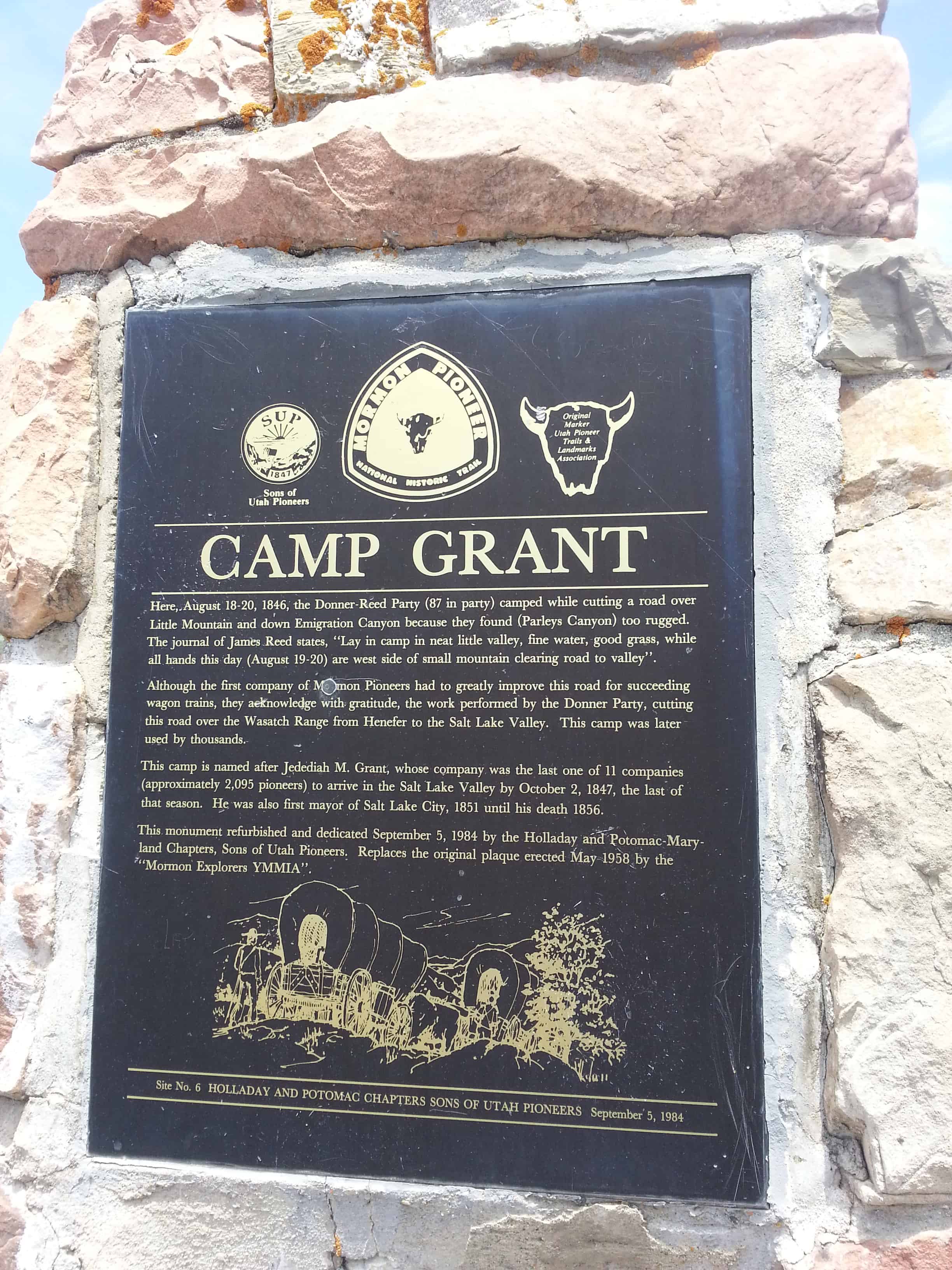
| 6 | Camp Grant | East Canyon, Salt Lake, Utah | Distant Close up | N 40.76069 W 111.70866 |
| 7 | Early Riverton and the Magnificent Dome Church | Riverton, Salt Lake, Utah | Distant Close up | N 40.51965 W 111.93351 |
| 8 | The Old Mill | Cedar City, Iron, Utah | Distant Close up | N 37.67278 W 113.04384 |
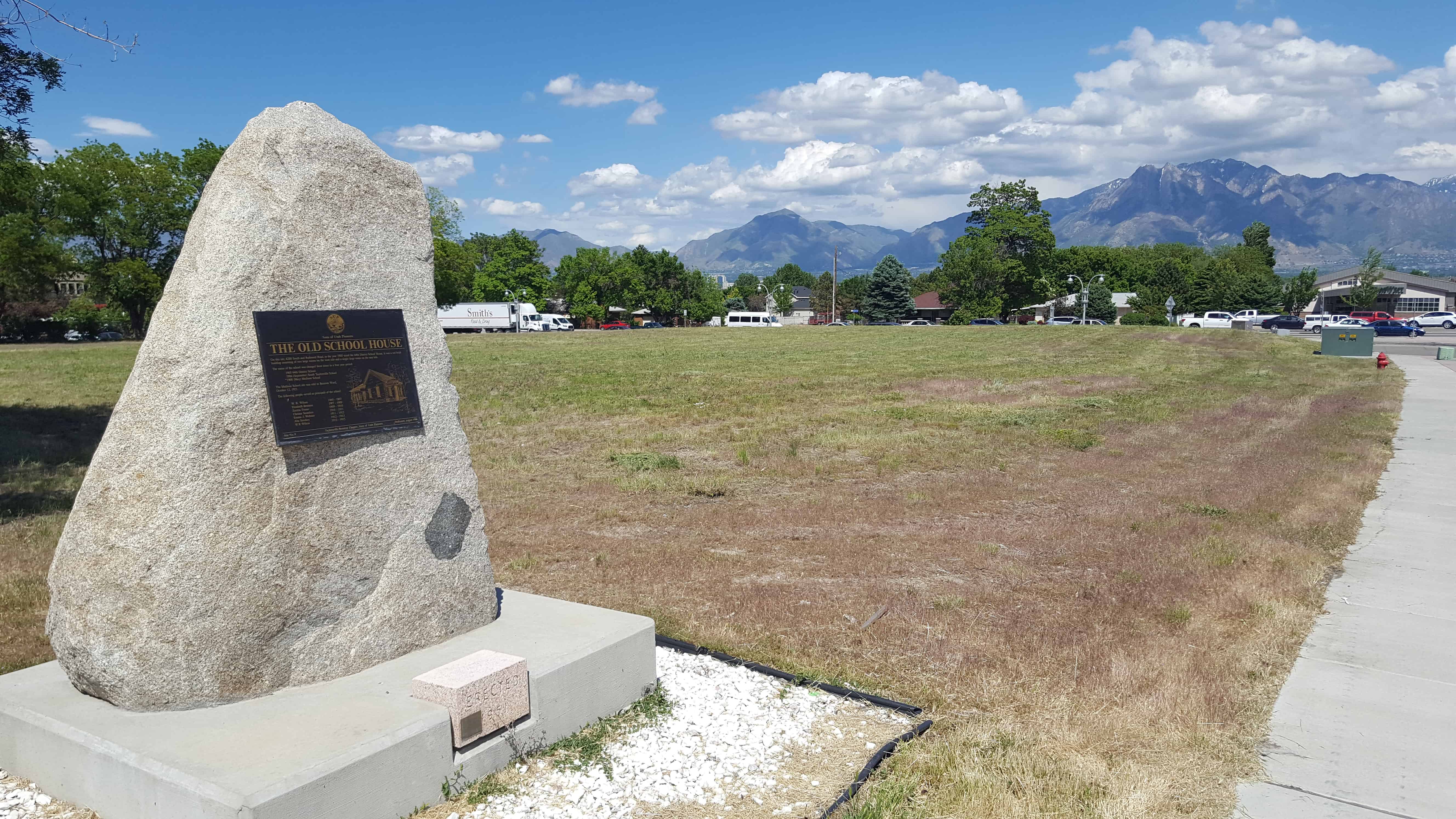
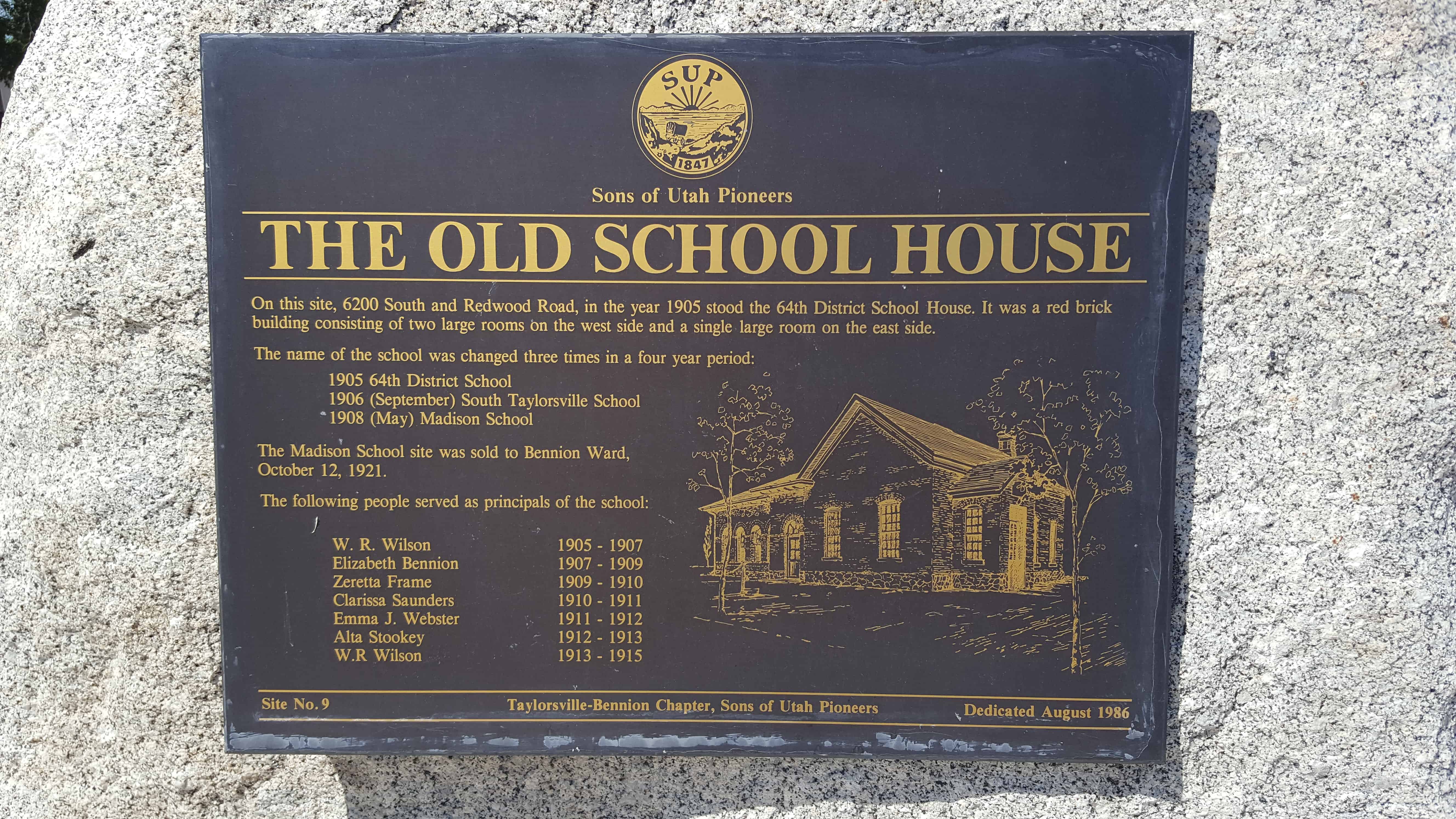
| 9 (Also #50) | The Old School House | Taylorsville, Salt Lake, Utah | Distant Close up | N 40.63887 W 111.94008 |
| 10 | William Ajax Underground Store | Tooele, Tooele, Utah | Photo | |
| 11 | Early Sandy Schools & Church Takes Root in Sandy | Sandy, Salt Lake, Utah | Distant Close up | N 40.59186 W 111.88227 |
| 12 | Utah Idaho Sugar Company Factory | Salt Lake City, Salt Lake, Utah | Distant Close up | N 40.60694 W 111.94296 |
| 13 | Tribute to Taylorsville-Bennion Pioneers | Taylorsville, Salt Lake, Utah | Distant Close up | N 40.66347 W 111.93015 |
| 14 | Early Arizona Pioneers | St. Johns, Apache, Arizona | N 34.51448 W 109.37199 | |
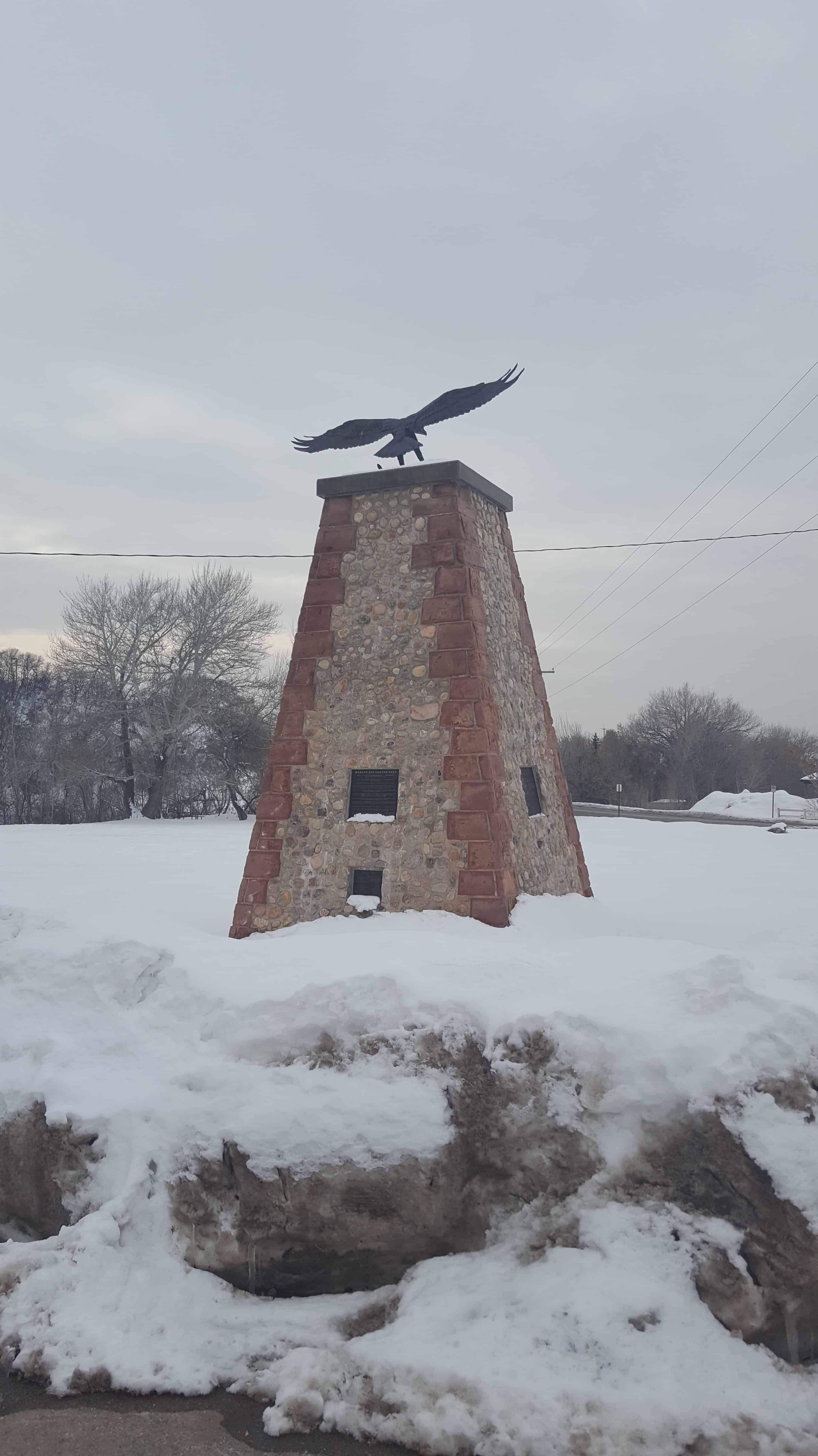
| 15 | Birth of Hurricane | Hurricane, Washington, Utah | Distant Close up | N 37.17963 W 113.28264 |
| 16 | Legacy of the Black Pioneer | Salt Lake City, Salt Lake, Utah | Distant Close up | N 40.69661 W 111.82717 |
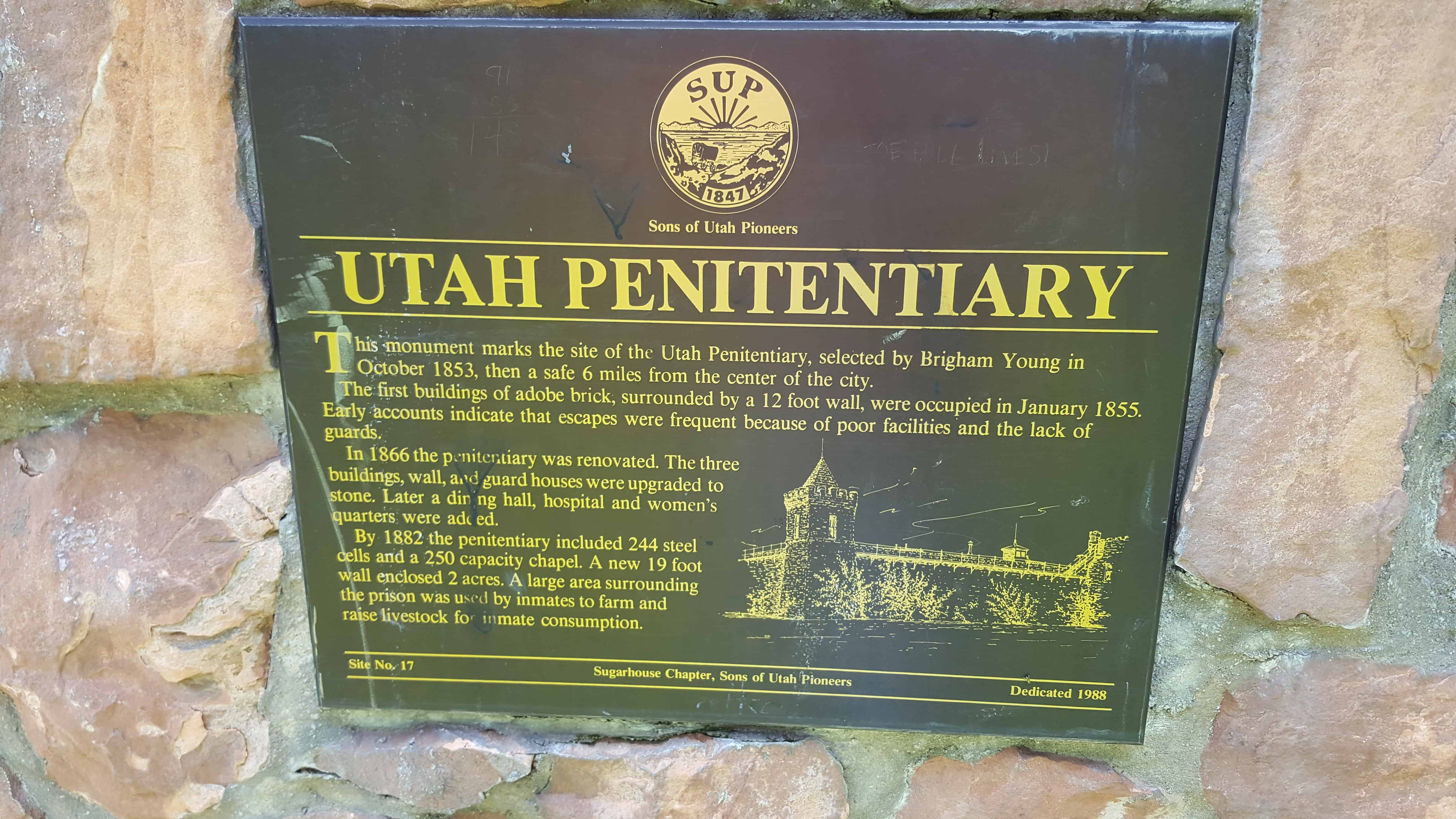
| 17 | Utah Penitentiary | Salt Lake City, Salt Lake, Utah | Distant Close up | N 40.72505 W 111.84813 |
| 18 | Old Tabernacle Lintel Stone | Provo, Utah, Utah | Distant Close up | N 40.23321 W 111.65971 |
| 19 | The Casting of the Lots | Cedar City, Iron, Utah | Distant Close up | N 37.68523 W 113.14348 |
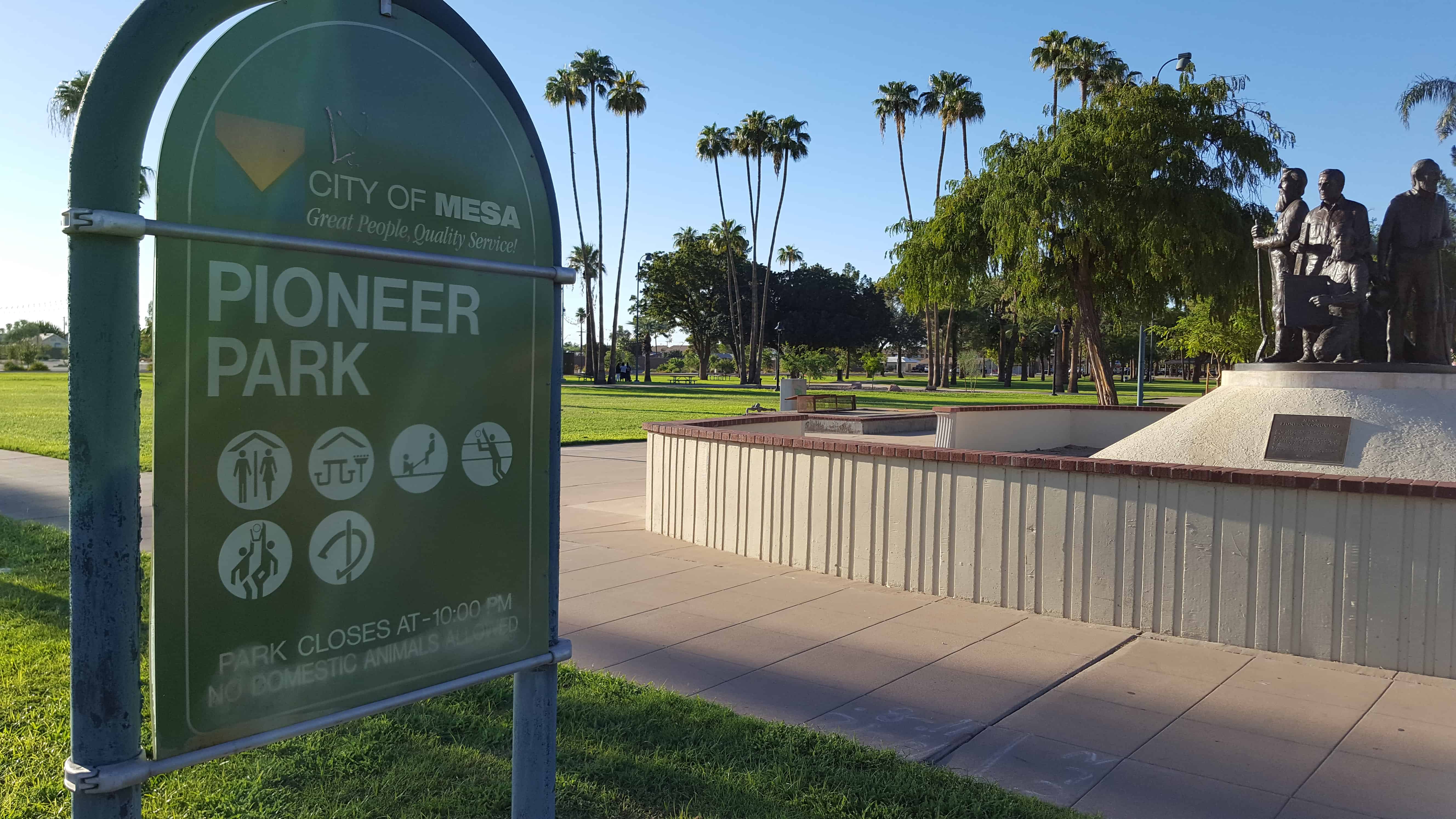
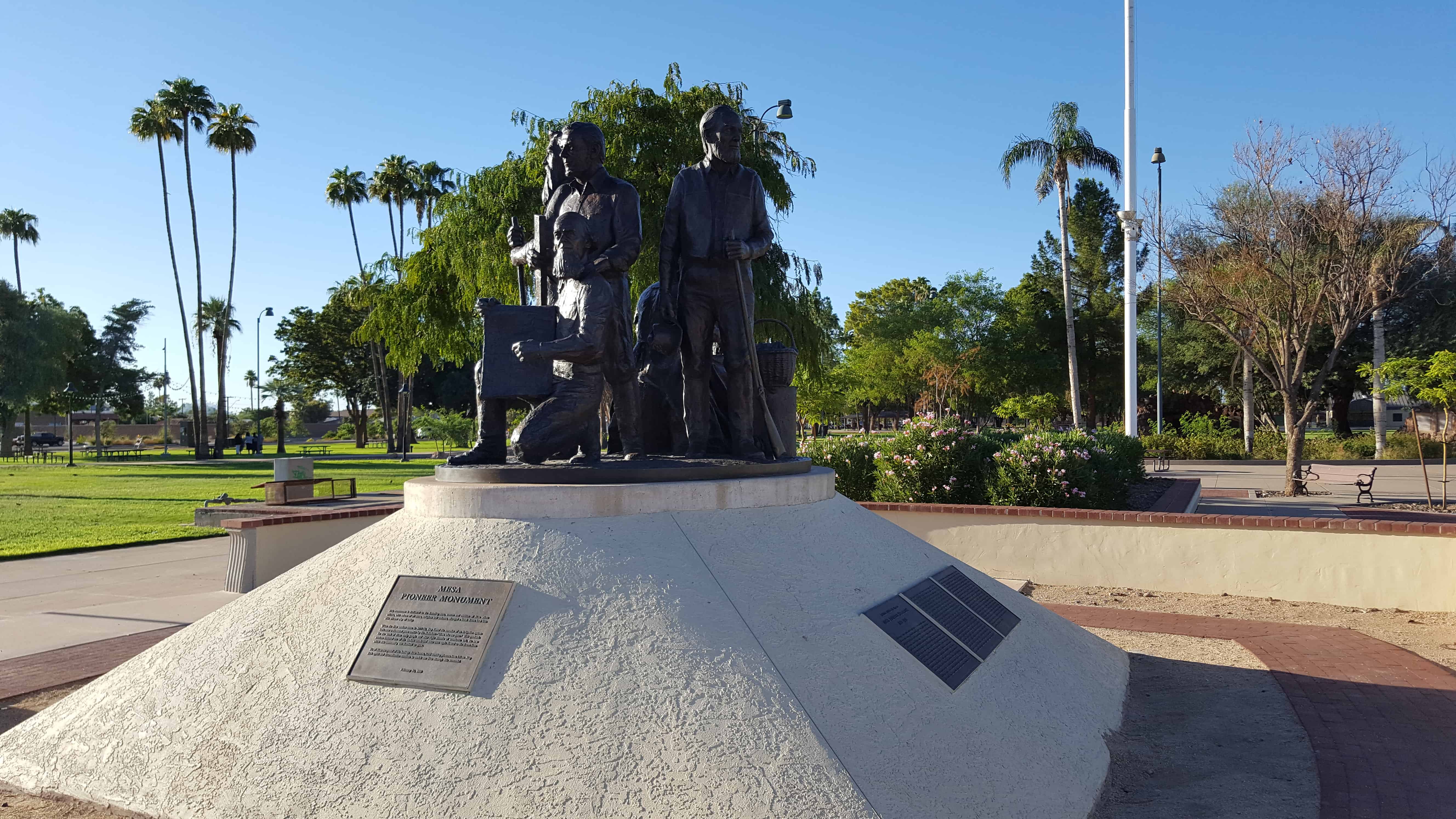
| 20 | Mesa Pioneer Monument | Mesa, Maricopa, Arizona | Distant Close up | N 33.41528 W 111.81958 |
| 21 | Brigham City Tabernacle | Brigham City, Box Elder, Utah | Distant Close up | N 41.50544 W 112.01516 |
| 23 | Hurricane Valley Pioneer Heritage Park | Hurricane, Washington, Utah | N 37.17624 W 113.28852 | |
| 23-A | Noble Pioneers of Hurricane | Hurricane, Washington, Utah | Distant Close up | N 37.17624 W 113.28852 |
| 23-B | Early Public Buildings | Hurricane, Washington, Utah | Distant Close up | N 37.17624 W 113.28852 |
| 23-C | Hurricane City | Hurricane, Washington, Utah | Distant Close up | N 37.17624 W 113.28852 |
| 23-D | The Hurricane Canal | Hurricane, Washington, Utah | Distant Close up | N 37.17624 W 113.28852 |
| 23.1 | Ensign Peak | Salt Lake City, Salt Lake, Utah | Distant Close up | N 40.77666 W 111.89037 |
| 24 | Marriott Ward | Bountiful, Davis, Utah | (Monument is retired) | |
| 25 | Pioneer Care Center | Brigham City, Box Elder, Utah | Distant Close up | N 41.49491 W 112.01902 |
| 26 | Half Way House | Sandy, Salt Lake, Utah | Distant Close up | N 40.56331 W 111.89114 |
| 27 | Neff’s Station | Sandy, Salt Lake, Utah | Distant Close up | N 40.56331 W 111.89114 |
| 28 | Early Magna Settlements | Magna, Salt Lake, Utah | Distant Close up | N 40.68326 W 112.09141 |
| 29 | Emigration Canyon Railroad | Salt Lake City, Salt Lake, Utah | (Hogle Zoo inside of the entrance) | |
| 30 | The Idaho Falls LDS Hospital and School of Nursing | Idaho Falls, Bonneville, Idaho | N 43.49726 W 112.04162 | |
| 31 | Original Gristmill Stones | Bountiful, Davis, Utah | Distant Close up | N 40.88024 W 111.87282 |
| 32 | Birthplace of Pioneer Pilot Russell L. Maughan | Logan, Cache, Utah | Distant Close up | N 41.73143 W 111.83164 |
| 33 | South Cottonwood Campground | Murray, Salt Lake, Utah | Distant Close up | N 40.64860 W 111.87033 |
| 34 | Mormon Lumber Road | Highway 18, San Bernardino, California | N 34.23350 W 117.29381 | |
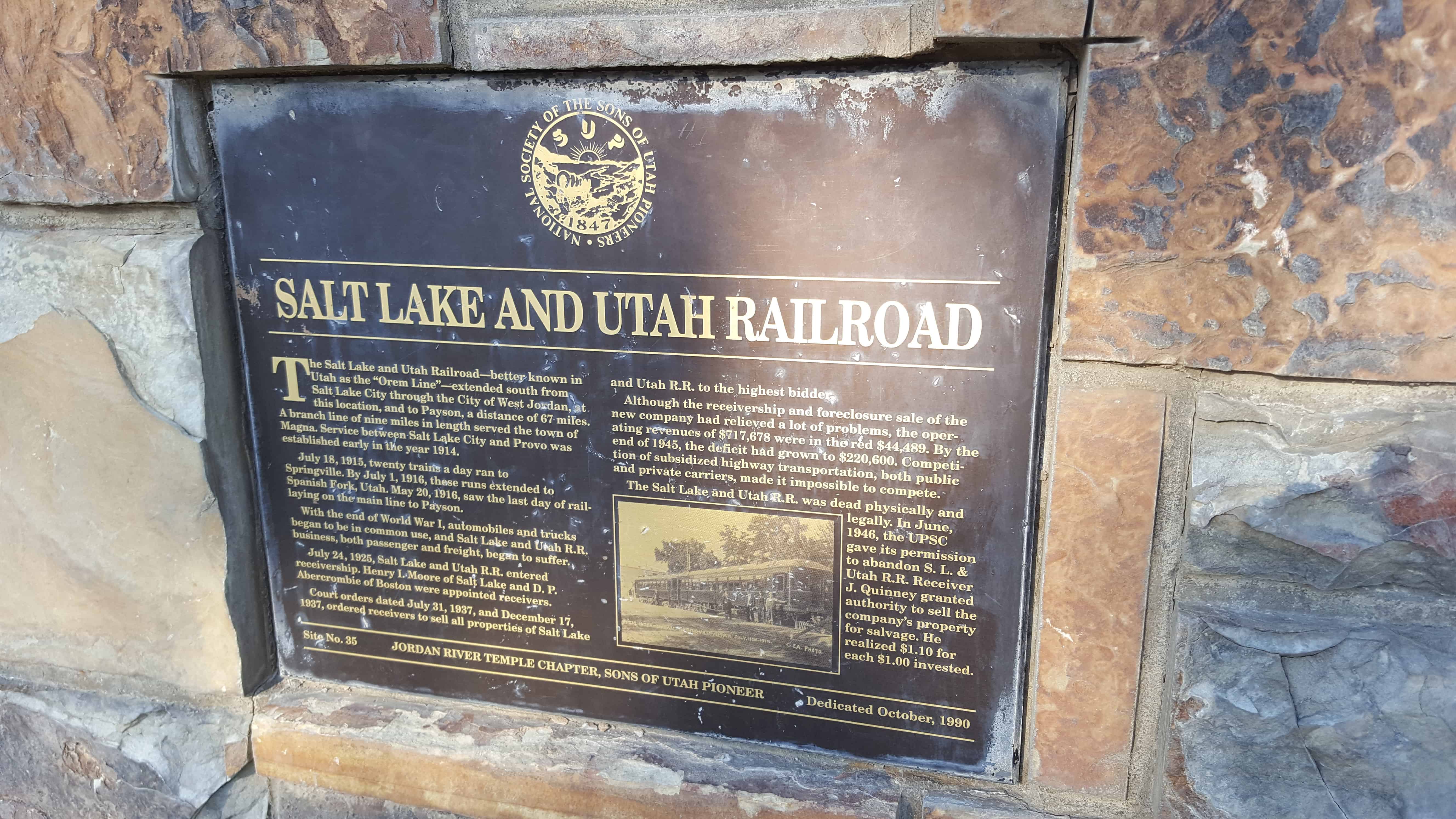
| 35 | Salt Lake and Utah Railroad | Salt Lake City, Salt Lake, Utah | Distant Close up | N 40.60694 W 111.94296 |
| 36 (also UPTLA #38) | Mormon Station – Genoa | Genoa, Douglas, Nevada | ||
| 37 | Brigham Young Industrial Center | Salt Lake City, Salt Lake, Utah | Distant Close up | N 40.71559 W 111.83420 |
| 38 | Ellen (Nellie) Purcell Unthank | Cedar City, Iron, Utah | Distant Close up | 400 W. 200 S. |
| 39 | Jordan & Salt Lake City Canal | Sugarhouse, Salt Lake, Utah | Distant Close up | N 40.72530 W 111.86017 |
| 40 | Palatkwapi Trail | Stoneman Lake, Coconino, Arizona | N 34.78363 W 111.51845 | |
| 41 | Old Chapel – Rest Stop | Murray, Salt Lake, Utah | Distant Close up | N 40.64860 W 111.87021 |
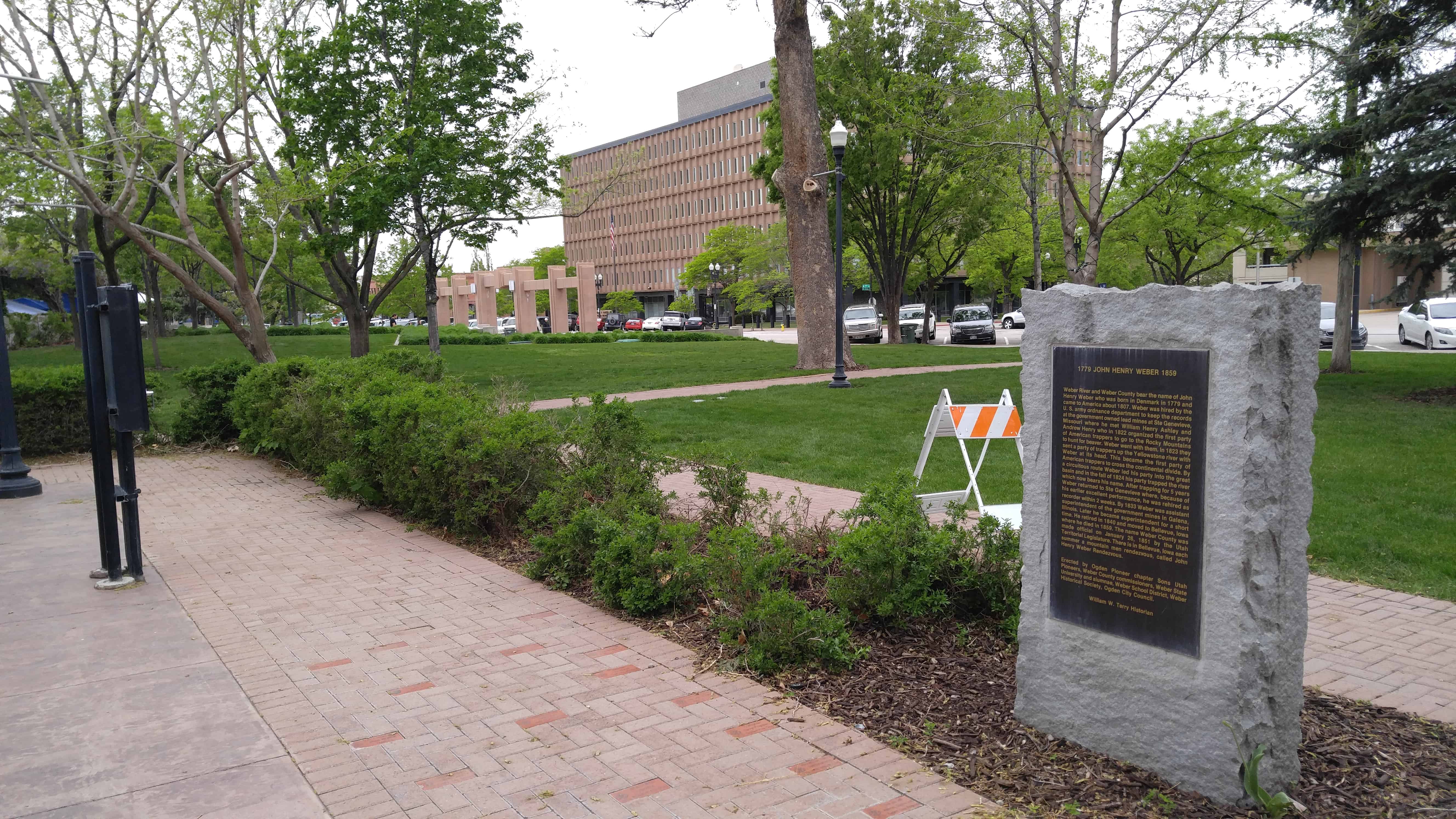
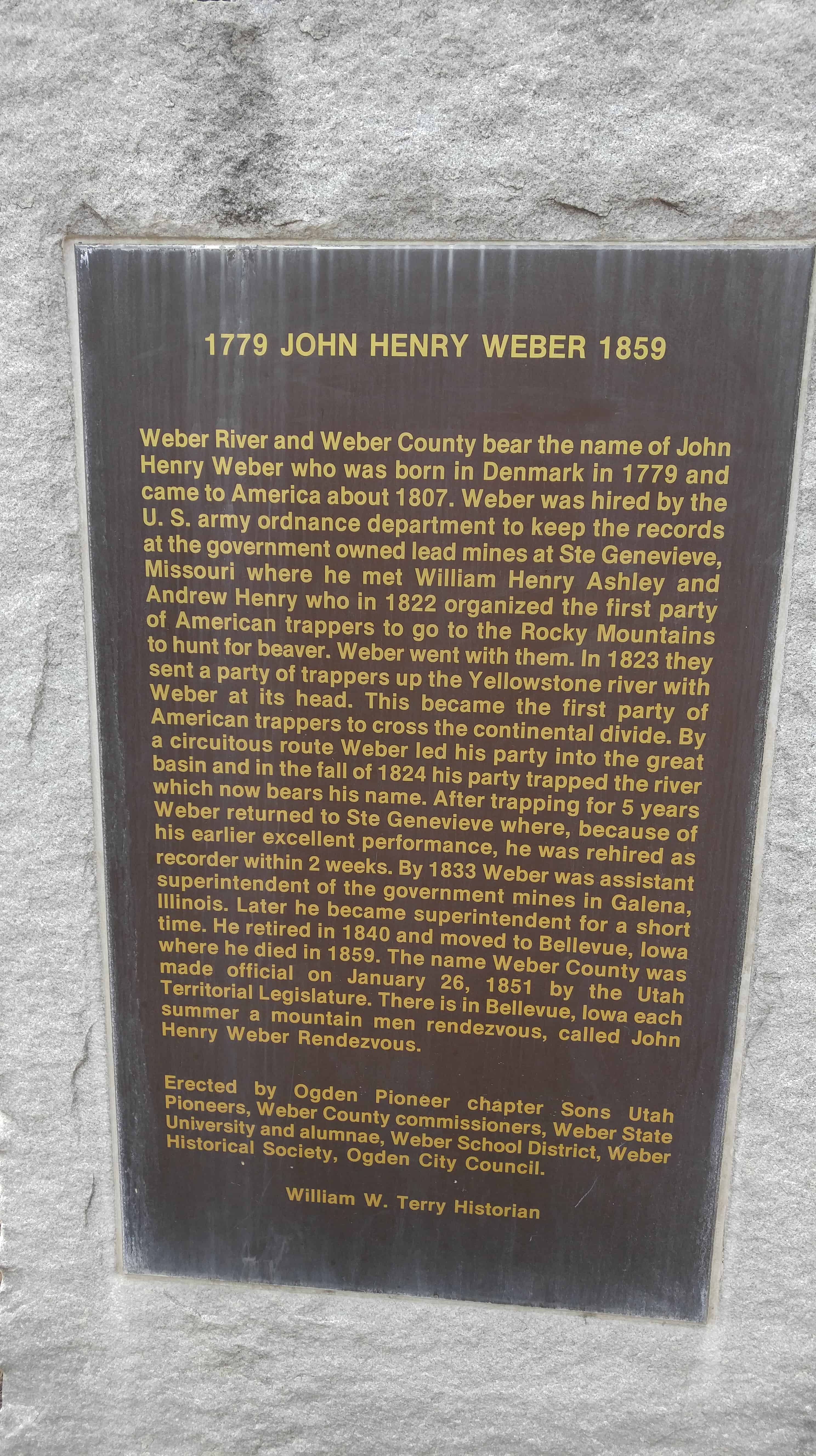
| 42 | John Henry Weber | Ogden, Weber, Utah | Distant Close up | N 41.22028 W 111.97125 |
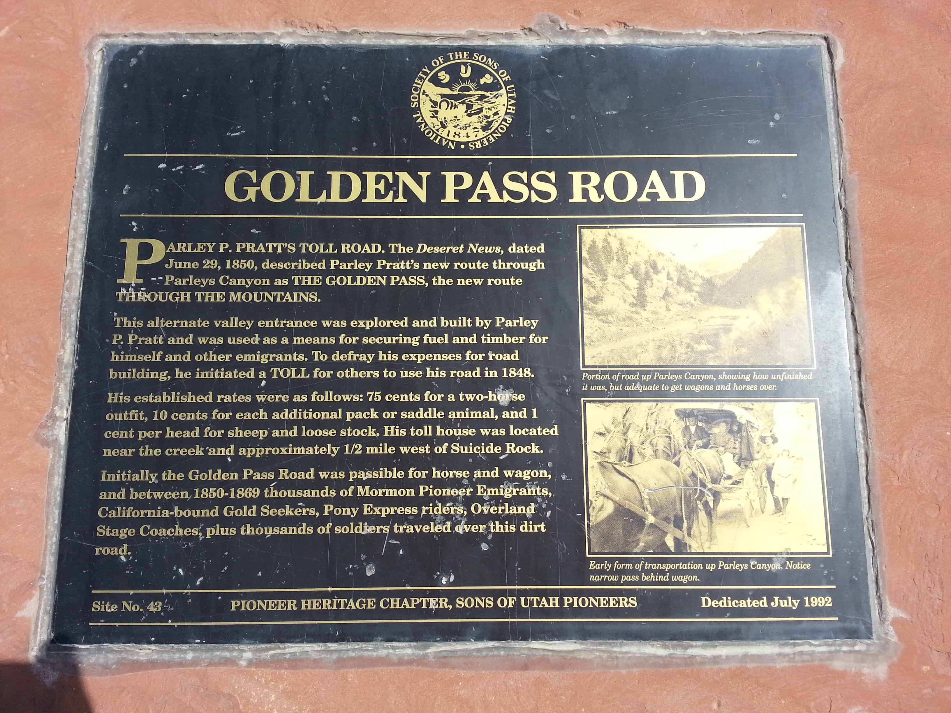
| 43 | Golden Pass Road | Salt Lake City, Salt Lake, Utah | Distant Close up | N 40.71559 W 111.83420 |
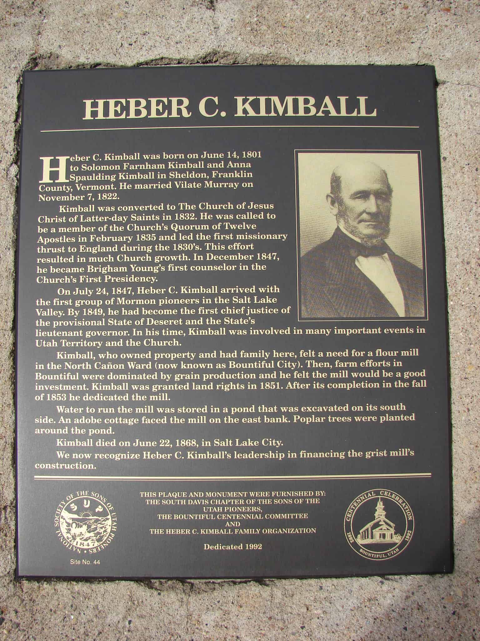
| 44 | Heber C. Kimball | Bountiful, Davis, Utah | Distant Close up | N 40.88024 W 111.87282 |
| 45 | Daniel Davis | Bountiful, Davis, Utah | Distant Close up | N 40.88024 W 111.87282 |
| 46 | George Quinn McNeil | Bountiful, Davis, Utah | Distant Close up | N 40.88024 W 111.87282 |
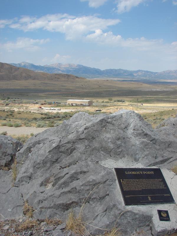
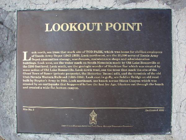
| 47 | Lookout Point | Tooele, Tooele, Utah | Distant Close up | N 40.47705 W 112.34768 |
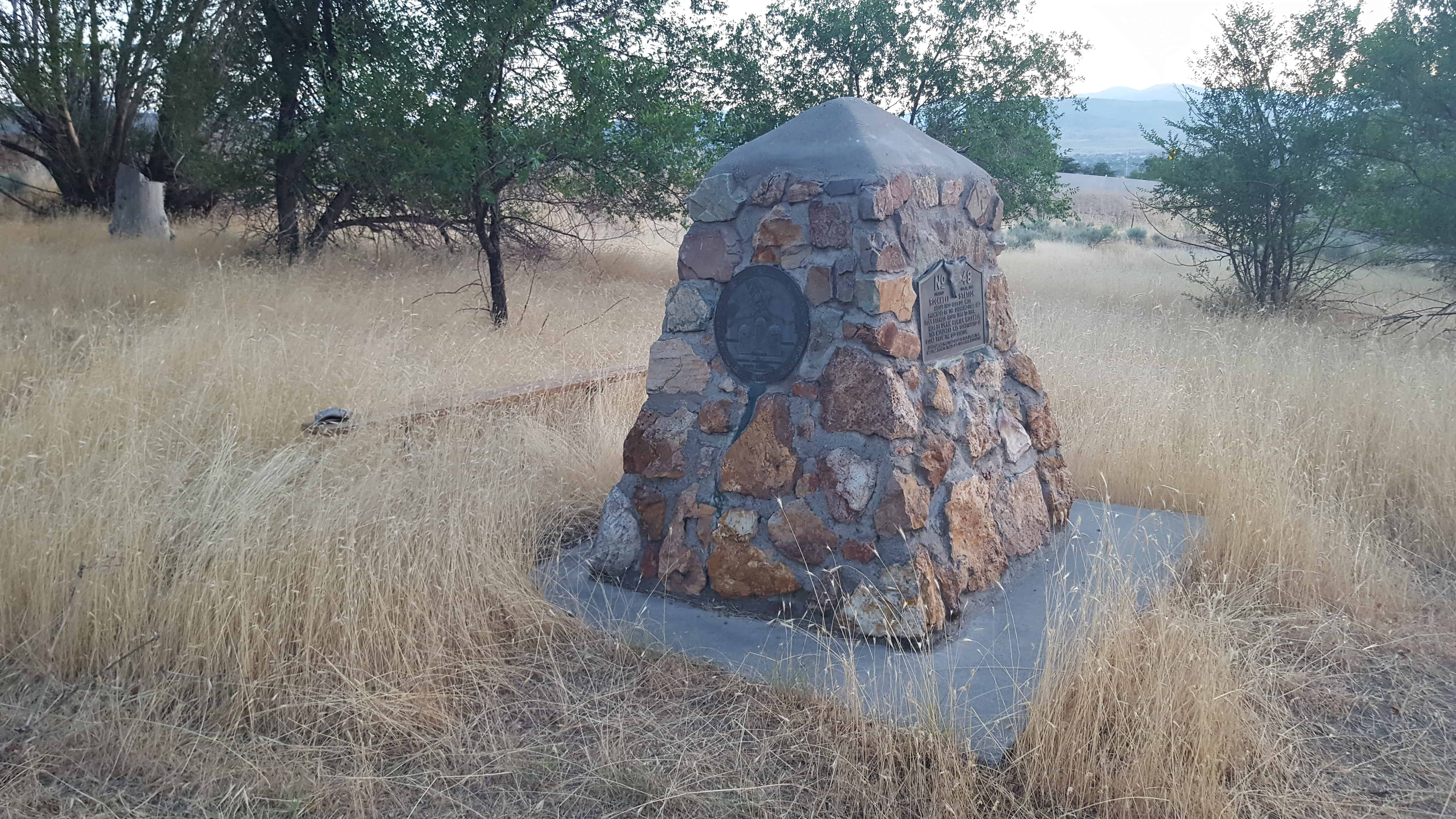
| 48 & 92 | Buffalo Park | Lake Point, Tooele, Utah | Distant Close up | N 40.69233 W 112.26234 |
| 49 | Mormon Pioneers at Fort Laramie | Fort Laramie, Goshen, Wyoming | N 42.21289 W 104.51665 | |
| 50 & 9 | The Old School House | Taylorsville, Salt Lake, Utah | Distant Close up | N 40.63887 W 111.94008 |
| 51 & 187 | Little Mountain Summit | Emigration Canyon, Salt Lake, Utah | Distant Close up | N 40.77495 W 111.71830 |
| 52 | Mormon-Carson Pass Emigrant Trail | Carson Pass, Alpine, California | N 38.64163 W 120.13632 | |
| 53 | Anderson Tower | Salt Lake City, Salt Lake, Utah | Distant Close up | N 40.77645 W 111.88378 |
| 54 | Old Brickyard Chimney | Salt Lake City, Salt Lake, Utah | Distant Close up | N 40.70335 W 111.85985 |
| 55 | Box Elder Fort | Brigham City, Box Elder, Utah | Distant Close up | N 41.51672 W 112.01863 |
| 56 | Johnson Canyon Cemetery | Kanab, Kane, Utah | Thirteen miles east of Kanab | |
| 57 | Harrisburg Residents | Harrisburg, Washington, Utah | Distant Close up | N 37.20747 W 113.39275 |
| 58 | Dan Jones, Welch Missionary | Provo, Utah, Utah | Painting at the MTC | |
| 59 | Genoa First Cabin | Genoa, Douglas, Nevada | ||
| 60 | Cedar Fort Marker, (formerly listed as Iron Mines) | Cedar City, Iron, Utah | Distant Close up | N 37.68830 W 113.07972 |
| 61 & 62 | Taylorsville–Bennion Cemetery & Cemetery Flagpole | Taylorsville, Salt Lake, Utah | Distant Close up | N 40.67081 W 111.93786 |
| 63 | Temple Fork Sawmill | Logan Canyon, Cache, Utah | N 41.83541 W 111.59341 | |
| 64 | Lambs Canyon | Salt Lake City, Salt Lake, Utah | Distant Close up | N 40.70859 W 111.80188 |
| 65 | First Settlers of Holladay | Holladay, Salt Lake, Utah | Distant Close up | N 40.66563 W 111.82157 |
| 66 | Memorial to Centerville Pioneers | Centerville, Davis, Utah | Distant Close up | N 40.92033 W 111.87872 |
| 67 | Little Emigration Canyon | Little Emigration Canyon, Morgan, Utah | Distant Close up | N 40.81552 W 111.58490 |
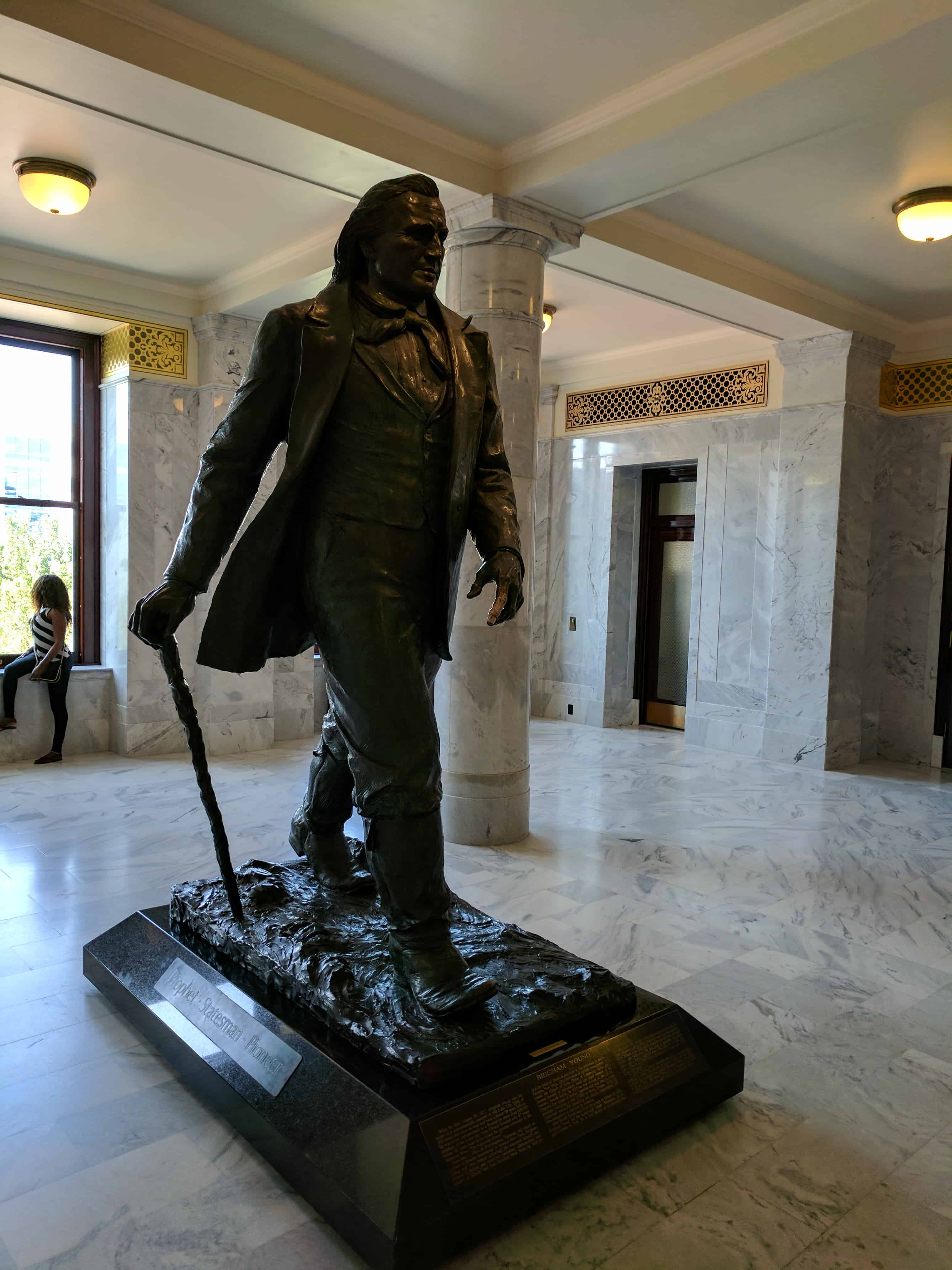
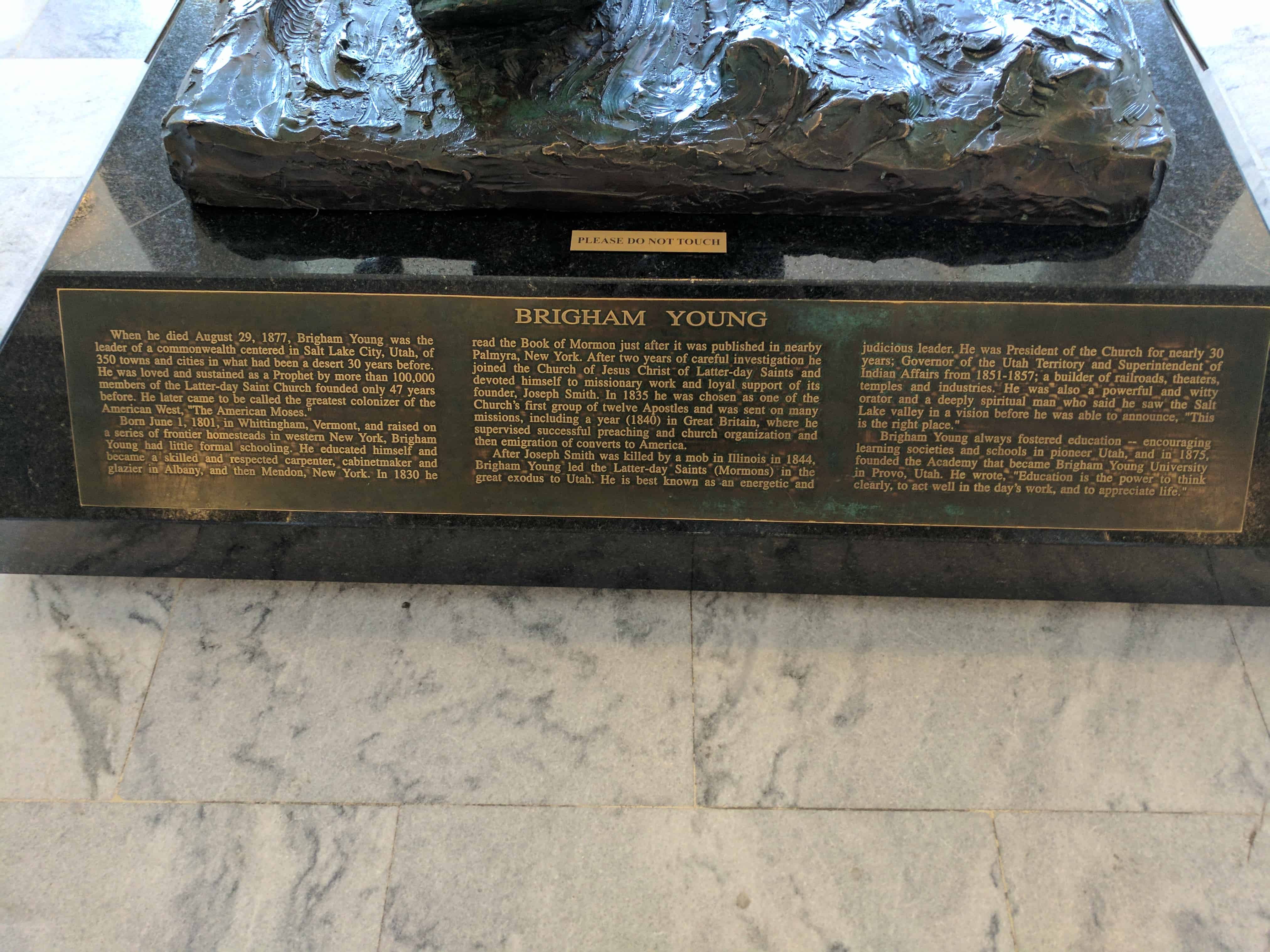
| 68 | Brigham Young Statue | Salt Lake City, Salt Lake, Utah | Distant Close up | N 40.77772 W 111.88821 |
| 69 | Hilda Anderson Erickson | Grantsville, Tooele, Utah | Distant Close up | N 40.59990 W 112.44628 |
| 70 | Murray Mill | Murray, Salt Lake, Utah | Monument Retired | |
| 71 | A Struggle for Water, West of the Jordan River | West Valley, Salt Lake, Utah | (West Valley City Park) 4500 West 3500 South | |
| 72 | St. George Memorial Plaza | St. George, Washington, Utah | Photo | N 37.10947 W 113.58317 |
| 72.01 | And the Desert Shall Blossom | St. George, Washington, Utah | Distant Close up | N 37.10947 W 113.58317 |
| 72.02 | Gardners’ Club Hall | St. George, Washington, Utah | Distant Close up | N 37.10947 W 113.58317 |
| 72.03 | St. George Social Hall “Opera House” | St. George, Washington, Utah | Distant Close up | N 37.10947 W 113.58317 |
| 72.04 | Brigham Young Home | St. George, Washington, Utah | Distant Close up | N 37.10947 W 113.58317 |
| 72.05 | Pioneer Courthouse | St. George, Washington, Utah | Distant Close up | N 37.10947 W 113.58317 |
| 72.06 | Erastus Snow’s Big House | St. George, Washington, Utah | Distant Close up | N 37.10947 W 113.58317 |
| 72.07 | Dixie Academy | St. George, Washington, Utah | Distant Close up | N 37.10947 W 113.58317 |
| 72.08 | St. George Temple | St. George, Washington, Utah | Distant Close up | N 37.10947 W 113.58317 |
| 72.09 | St. George Tabernacle | St. George, Washington, Utah | Distant Close up | N 37.10947 W 113.58317 |
| 72.10 | Woodward School | St. George, Washington, Utah | Distant Close up | N 37.10947 W 113.58317 |
| 73 | Archibald Gardner Mill | Taylorsville, Salt Lake, Utah | Distant Close up | N 40.66705 W 111.90889 |
| 74 | Brigham City Co-Op | Brigham City, Box Elder, Utah | Distant Close up | N 41.51080 W 112.01923 |
| 75 | Dudler's Inn | Parley's Hollow, Salt Lake, Utah | Distant Close up | N 40.71101 W 111.80591 |
| 76 | Golden Pass Road and Tollhouse | Parley's Hollow, Salt Lake, Utah | Distant Close up | N 40.71043 W 111.80322 |
| 77 | Sandstone Wall & Aqueduct | Parley's Hollow, Salt Lake, Utah | Distant Close up | N 40.71166 W 111.80617 |
| 78 | The Railroad | Parley's Hollow, Salt Lake, Utah | Distant Close up | N 40.70967 W 111.80263 |
| 79 | Suicide Rock & the Reservoir | Parley's Canyon, Salt Lake, Utah | Distant Close up | N 40.708903 W 111.798332 |
| 80 | Dudlers Wine Cellar | Parley's Hollow, Salt Lake, Utah | Distant Close up | N 40.71101 W 111.80591 |
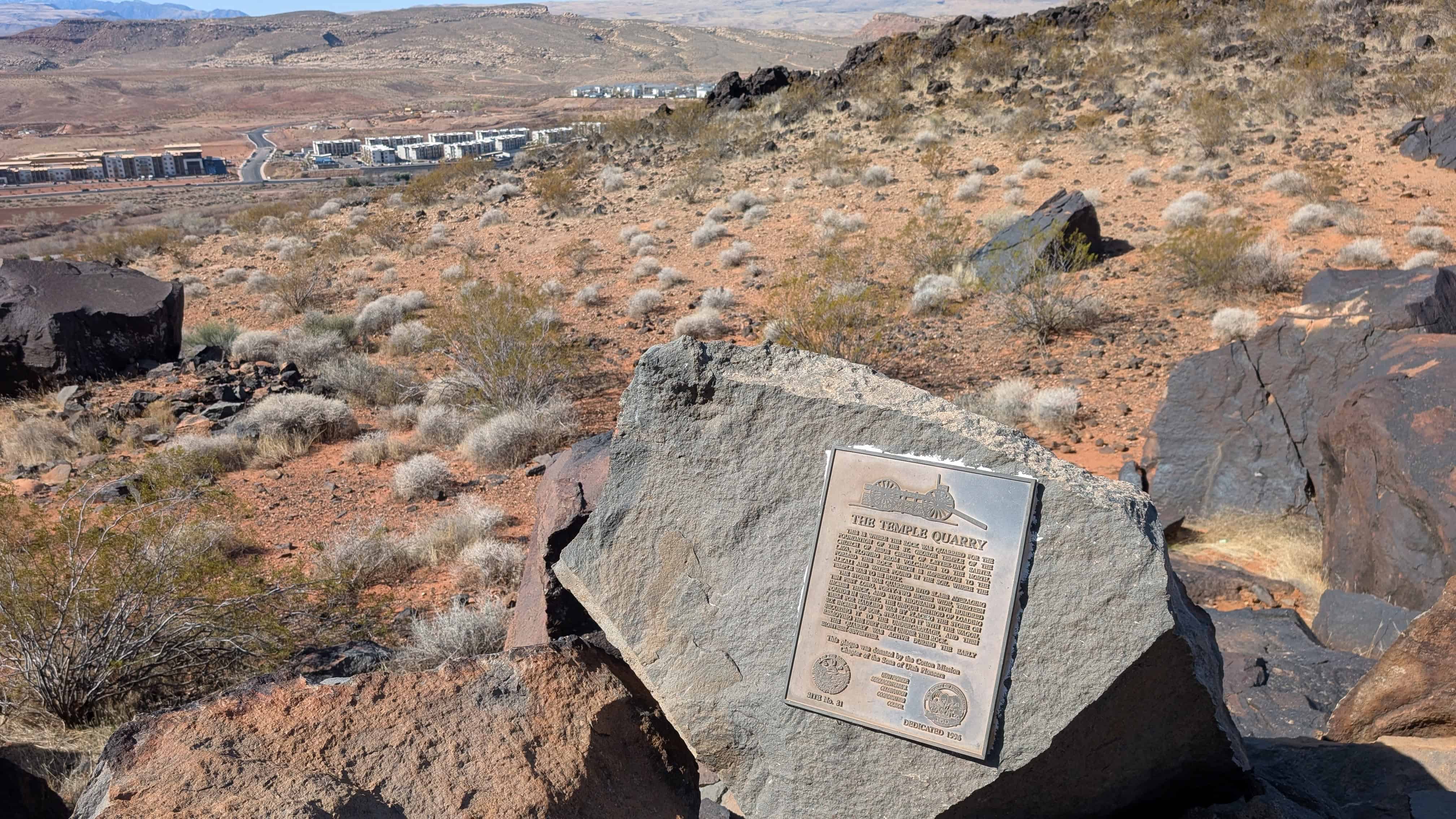
| 81 | The Temple Quarry | St. George, Washington, Utah | Distant Close up | N 37.09520 W 113.60505 |
| 82 | Last Campsite - Camp Kostopulous | Emigration Canyon, Salt Lake, Utah | 2500 E. Emigration Canyon Road | |
| 83 | East Canyon Campsites | East Canyon, Morgan, Utah | Distant Close up | N 40.87013 W 111.58447 |
| 84 | Mahonri Moriancumer Cahoon | Murray, Salt Lake, Utah | Distant Close up | N 40.65281 W 111.87268 |
| 85 | Temple Camp and Supplication Hills | Echo, Summit, Utah | Distant Close up | N 40.98579 W 111.44867 |
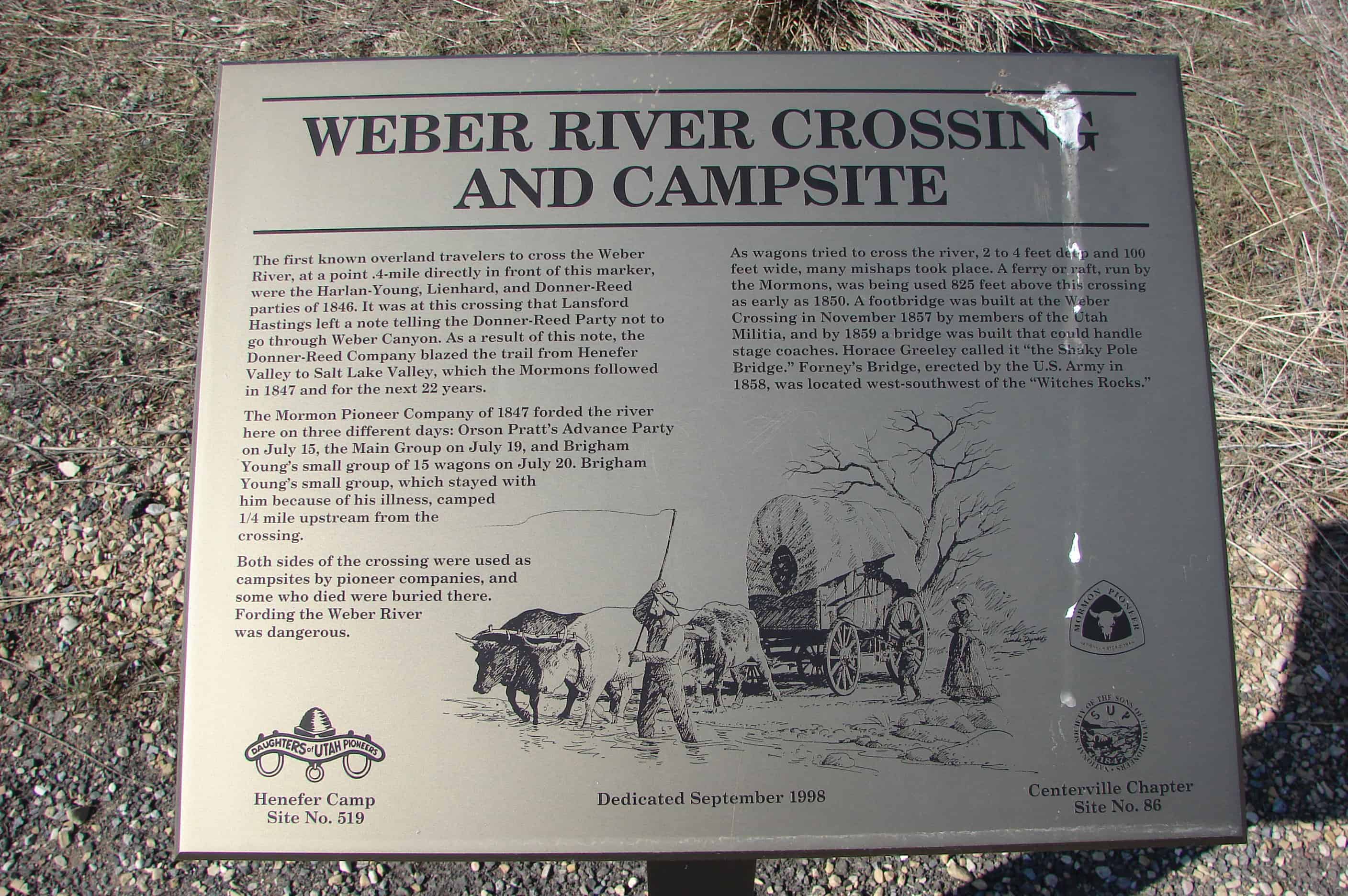
| 86 | Weber River Crossing and Campsite | Echo, Summit, Utah | Distant Close up | N 40.98579 W 111.44867 |
| 87 | Deputy Sheriff Rodney Badger Gave His Life | Echo, Summit, Utah | Distant Close up | N 40.98579 W 111.44867 |
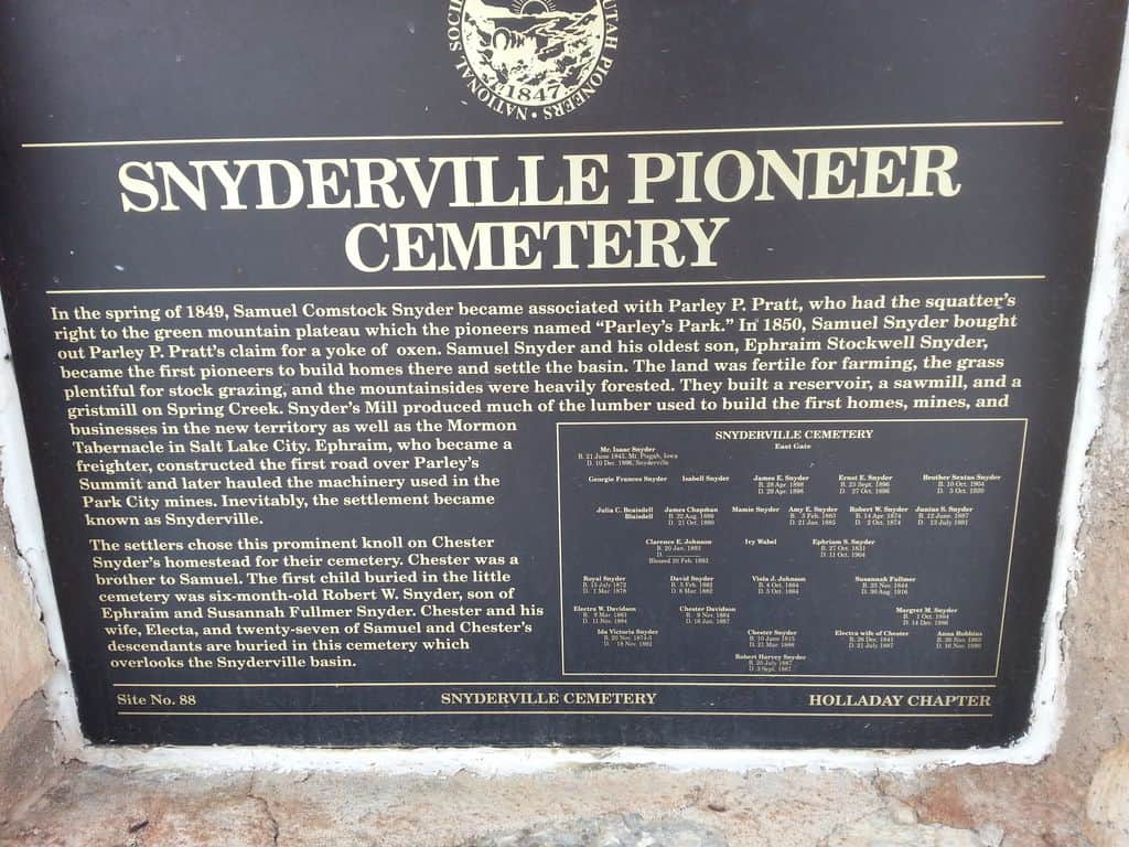
| 88 | Snyderville Pioneer Cemetery | Snyderville, Summit, Utah | Distant Close up | N 40.69789 W 111.54547 |
| 89 | Mt. Olympus Senior Center Flag Pole | Holladay, Salt Lake, Utah | Photo | N 40.66728 W 111.84522 |
| 90 | Old Tooele County Courthouse | Tooele, Tooele, Utah | Distant Close up | N 40.52952 W 112.29772 |
| 91 | Tooele City Pioneer Cemetery and Memorial Garden | Tooele, Tooele, Utah | Distant Close up | N 40.51648 W 112.30418 |
| 92 & 48 | Buffalo Park | Lake Point, Tooele, Utah | Distant Close up | N 40.69233 W 112.26234 |
| 93 | The Old Mill | Centerville, Davis, Utah | Distant Close up | N 40.91613 W 111.86899 |
| 94 | Stoney Point | North Ogden Canyon, Weber, Utah | ||
| 95 | Hamblin Cemetery | Hamblin, Washington, Utah | N 37.53631 W 113.60770 | |
| 96 | Angels Are Near Us | Salt Lake City, Salt Lake, Utah | Distant Close up | N 40.75266 W 111.81699 |
| 97 | Tooele City Pioneer Memorial | Tooele, Tooele, Utah | Distant Close up | N 40.53091 W 112.30248 |
| 98 | Carlisle Family Historical Marker | Salt Lake City, Salt Lake, Utah | Distant Close up | N 40.68733 W 111.92152 |
| 99.1 | Civilian Conservation Corps 1933-1942(Camp FS-18: Blue Spring Ridge) | Escalante, Garfield, Utah | 12 –13 miles north of Escalante, in Pine Canyon, near Posey Lake, on the road to Hell’s Backbone. | |
| 99.2 | Civilian Conservation Corps 1933-1942(Camp FS-44: Posey Lake) | Escalante, Garfield, Utah | 1 mile south of Posey Lake at “Aspen Grove” | |
| 100 | Builders of the Historic Hurricane Canal 1893-1905 | Hurricane, Washington, Utah | ||
| 101 | Evans Grain & Elevator Co-op | Lincoln, Bonneville, Idaho | N 43.51146 W 111.97336 | |
| 101-B | The Historic Hurricane Canal | Hurricane, Washington, Utah | Distant Close up | N 37.18315 W 113.27840 |
| 103 | 1902 Steam Engine | N 43.51146 W 111.97336 | ||
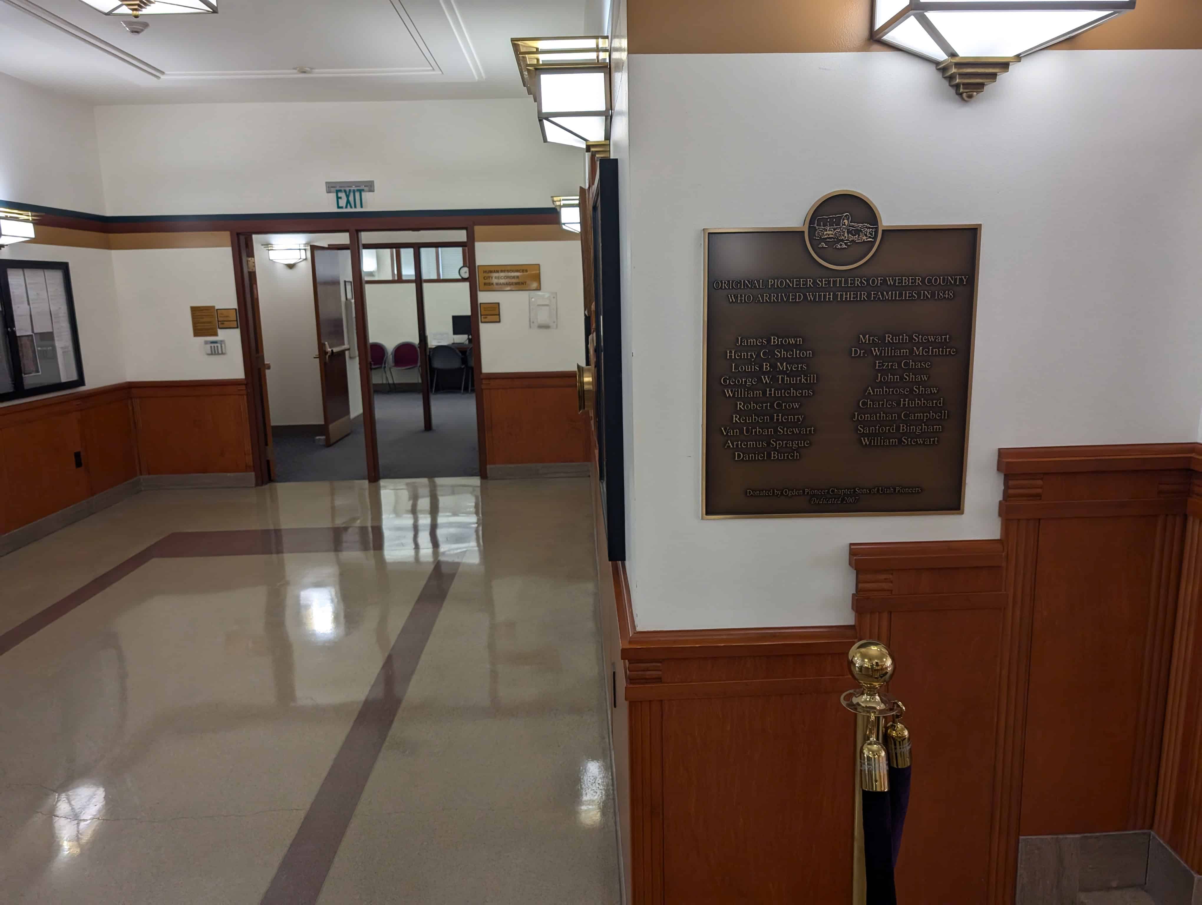
| 104 | Weber College – The Moench Building | Ogden, Weber, Utah | Distant Close up | N 41.22121 W 111.96497 |
| 105 | Lincoln Sugar Factory Steam Engine | Lincoln, Bonneville, Idaho | N 43.51146 W 111.97336 | |
| 108 | Civilian Conservation Corps 1933-1942(Camp FS-42: The Spring) | Escalante, Garfield, Utah | 1 mile east of Escalante at “The Spring” | |
| 109 | Civilian Conservation Corps 1933-1942(Camp 211, Main Canyon) | Escalante, Garfield, Utah | 12 miles west of Escalante at Water Canyon in Main Canyon | |
| 110.1 | Memories at Mountain Dell | Little Dell Res., Salt Lake, Utah | N 40.77818 W 111.68902 | |
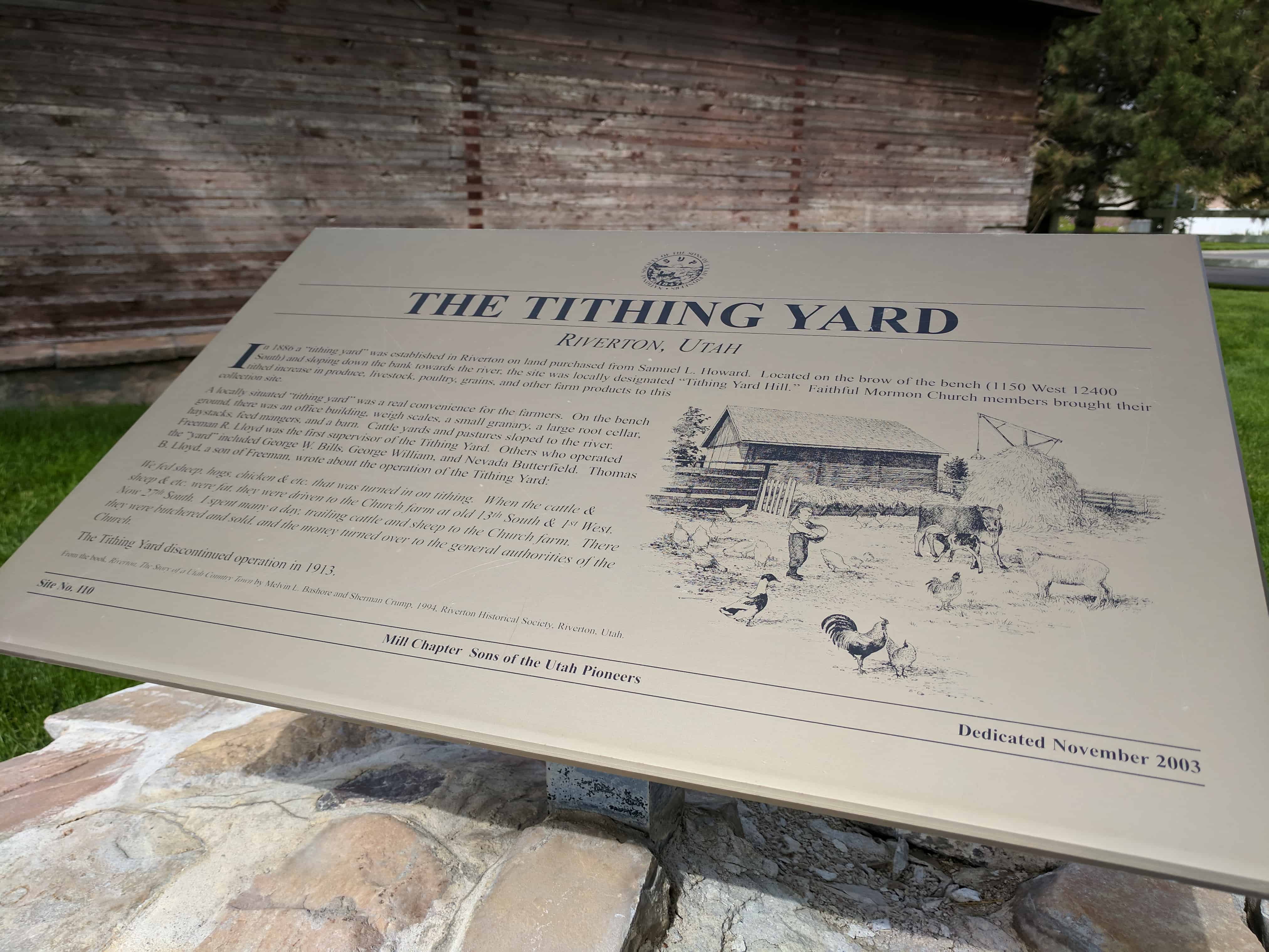
| 110.2 | The Tithing Yard | Riverton, Salt Lake, Utah | N 40.52569 W 111.92522 | |
| 110.3 | Jeremiah Willey Cabin | Bountiful, Davis, Utah | N 40.89280 W 111.88105 | |
| 111 | Early Rexburg | Rexburg, Madison, Idaho | N 43.82701 W 111.78421 | |
| 112 | Shem, Shivwits Indian Chieftain | St. George, Washington, Utah | Close up | N 37.10742 W 113.56968 |
| 116 | Freedom and Faith (Mormon Hollow) | Wallace, Chester, Pennsylvania | ||
| 117 | Millrace | Taylorsville, Salt Lake, Utah | Close up | N 40.65452 W 111.92462 |
| 118 | Richville Cemetery | Richville, Morgan, Utah | Distant Close up | N 41.00215 W 111.68952 |
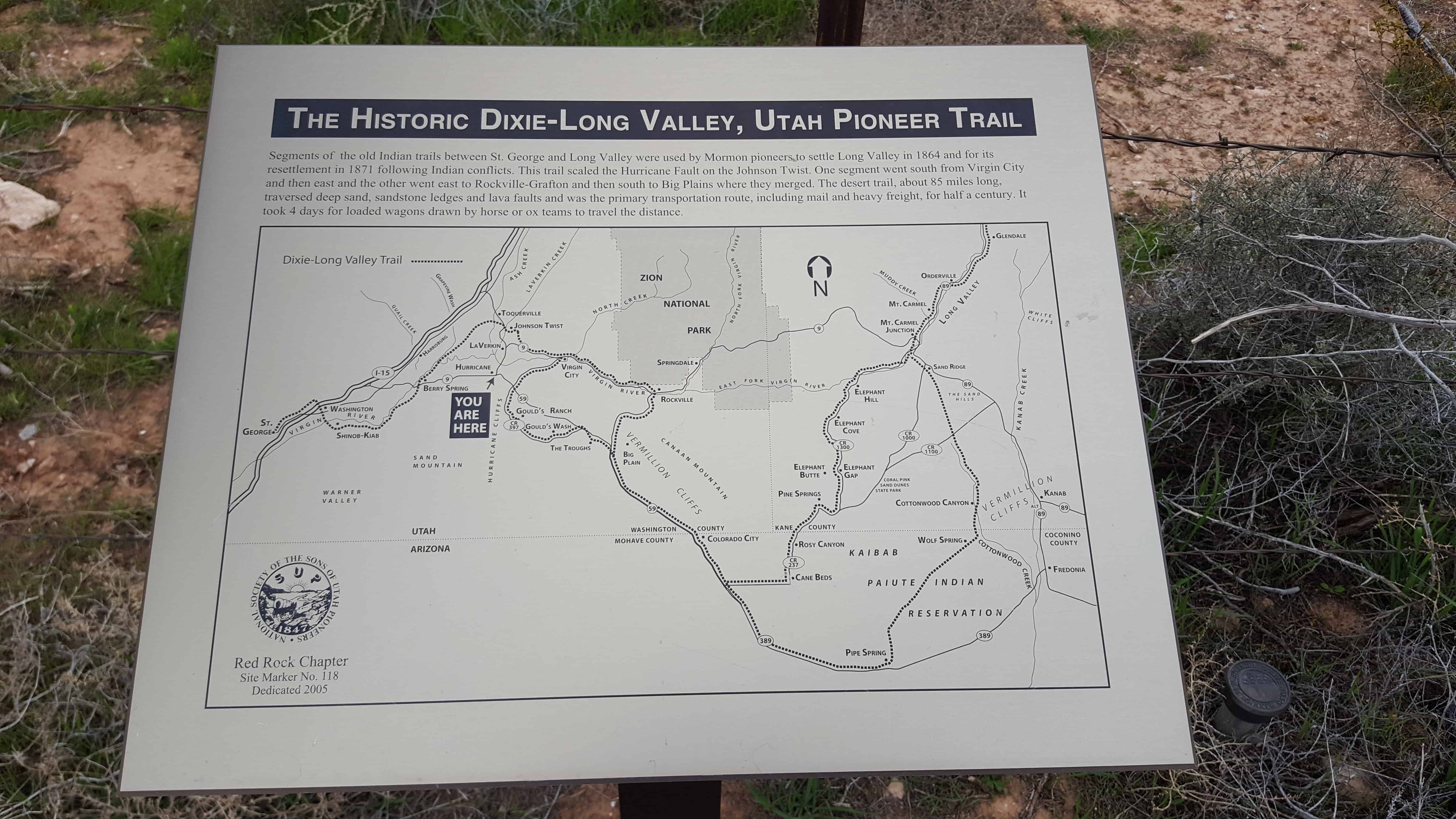
| 118.1 | The Historic Dixie-Long Valley, Utah Pioneer Trail | Hurricane, Washington, Utah | Distant Close up | N 37.18313 W 113.27842 |
| 119 | The Historic Dixie-Long Valley, Utah Pioneer Trail | Stoneman Lake, Coconino, Arizona | Distant Close up | N 36.94700 W 112.95547 |
| 120 | The Historic Dixie-Long Valley, Utah Pioneer Trail | Mt. Carmel Junction, Kane, Utah | Highway 89, .25 miles south Mt. Carmel Junction | |
| 122 | Logan to Brigham Pioneer Pony Express Mail Trail | Mantua, Box Elder, Utah | Mantua Town Square | |
| 123 | Wood for Pine Valley Chapel and Salt Lake Tabernacle Organ | Pine Valley, Washington, Utah | Distant Close up | N 37.39156 W 113.51469 |
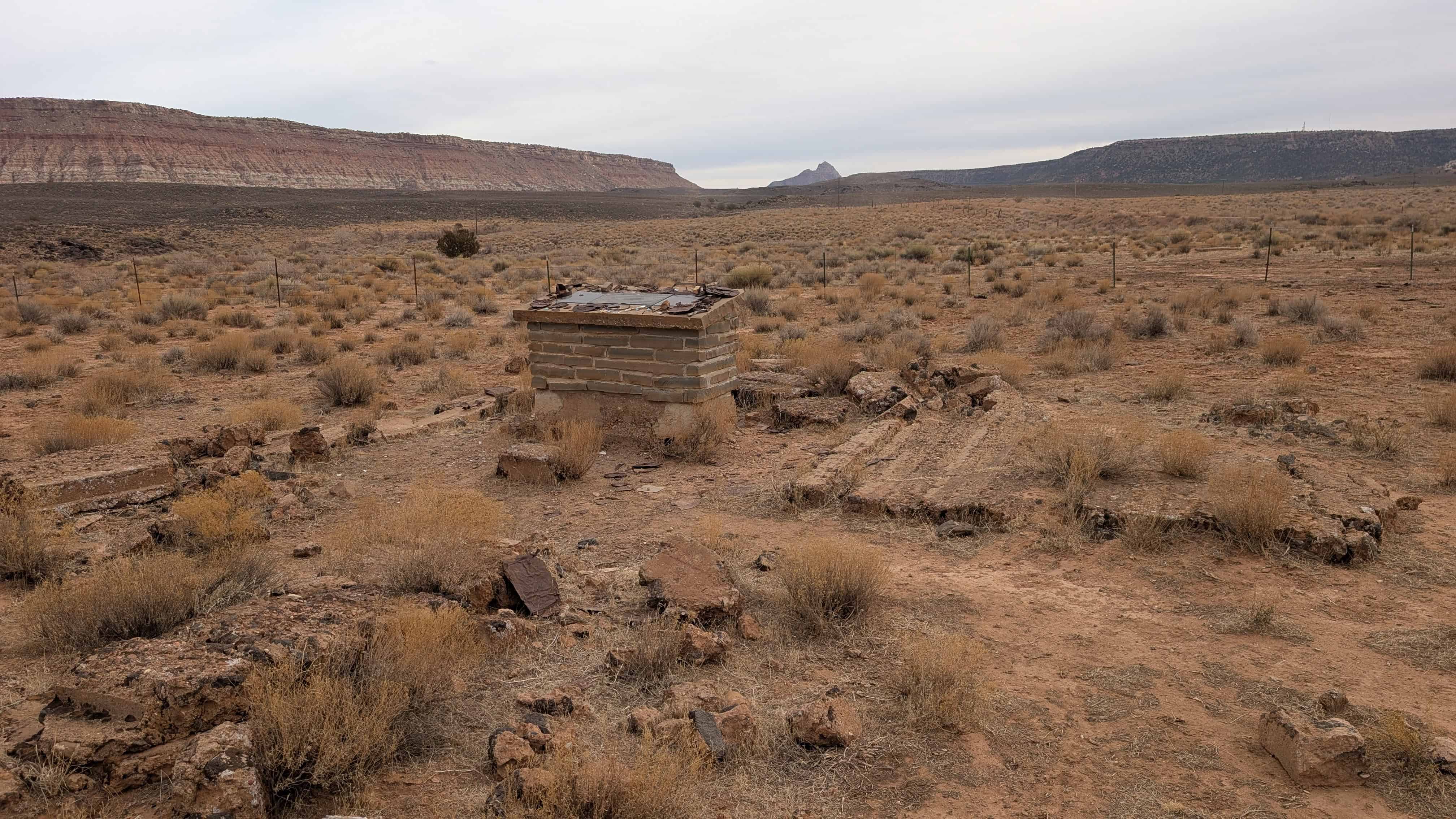
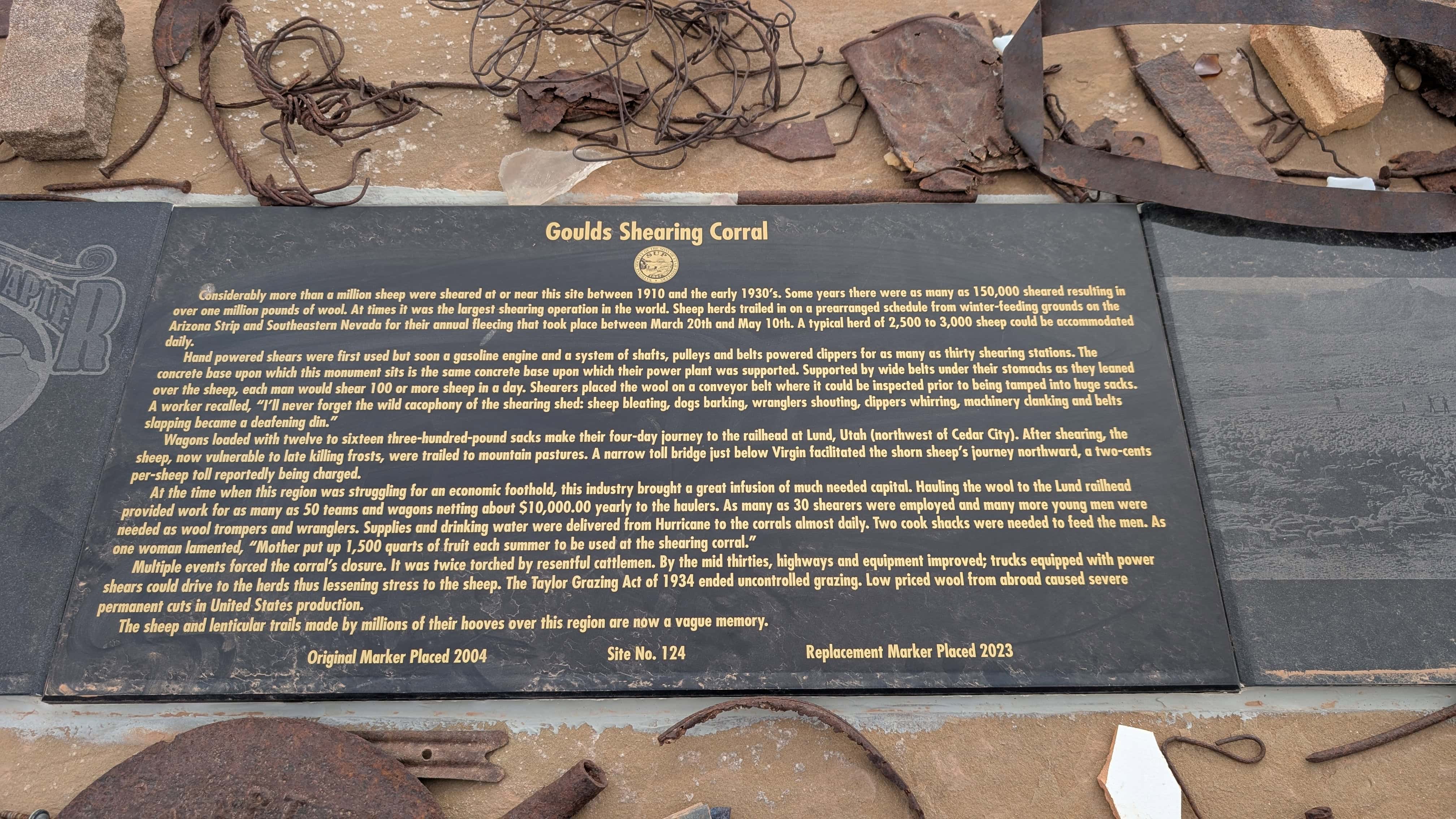
| 124 | Goulds Shearing Corral | Hurricane, Washington, Utah | Distant Close up | N 37.11723 W 113.24545 |
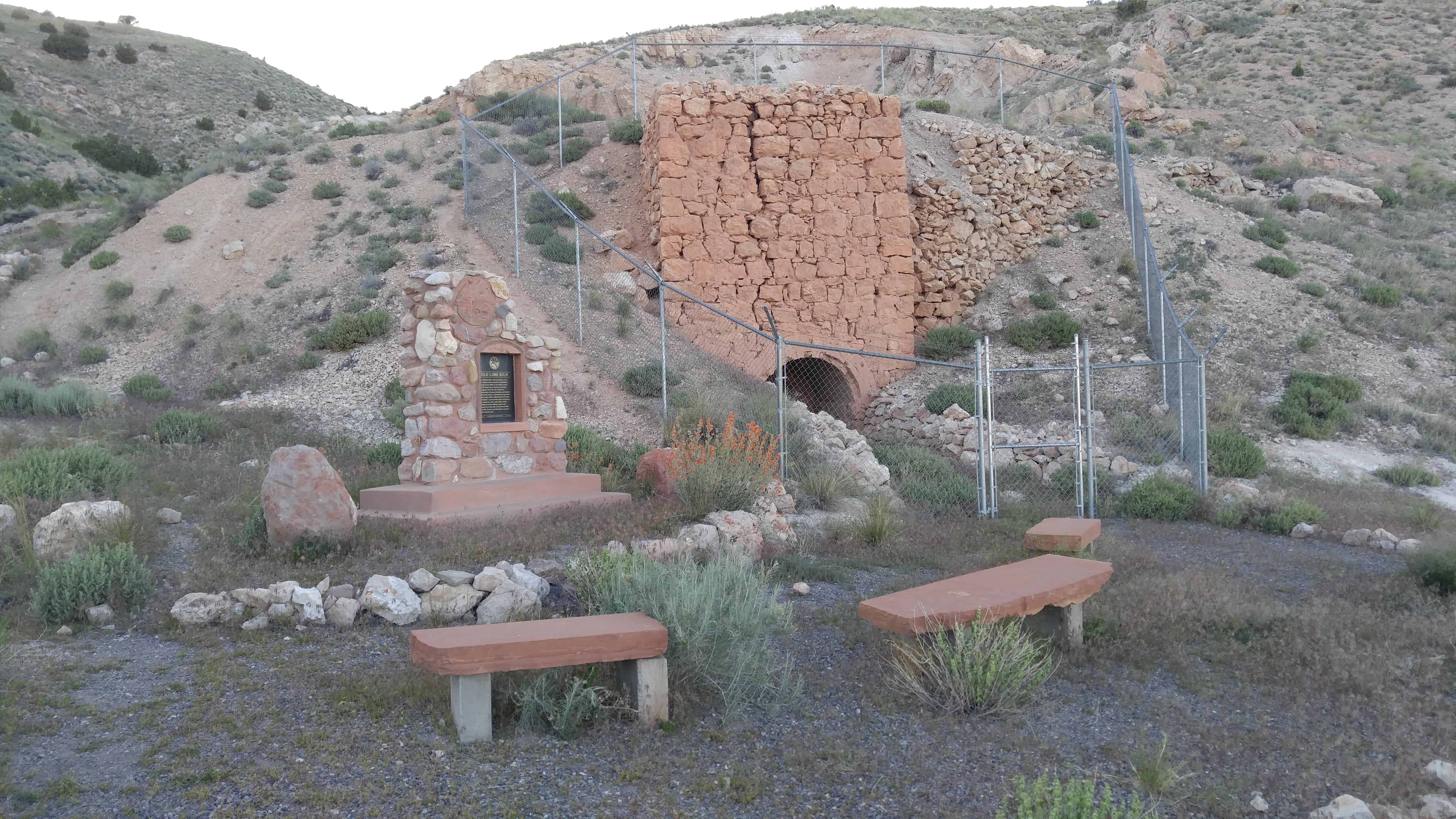
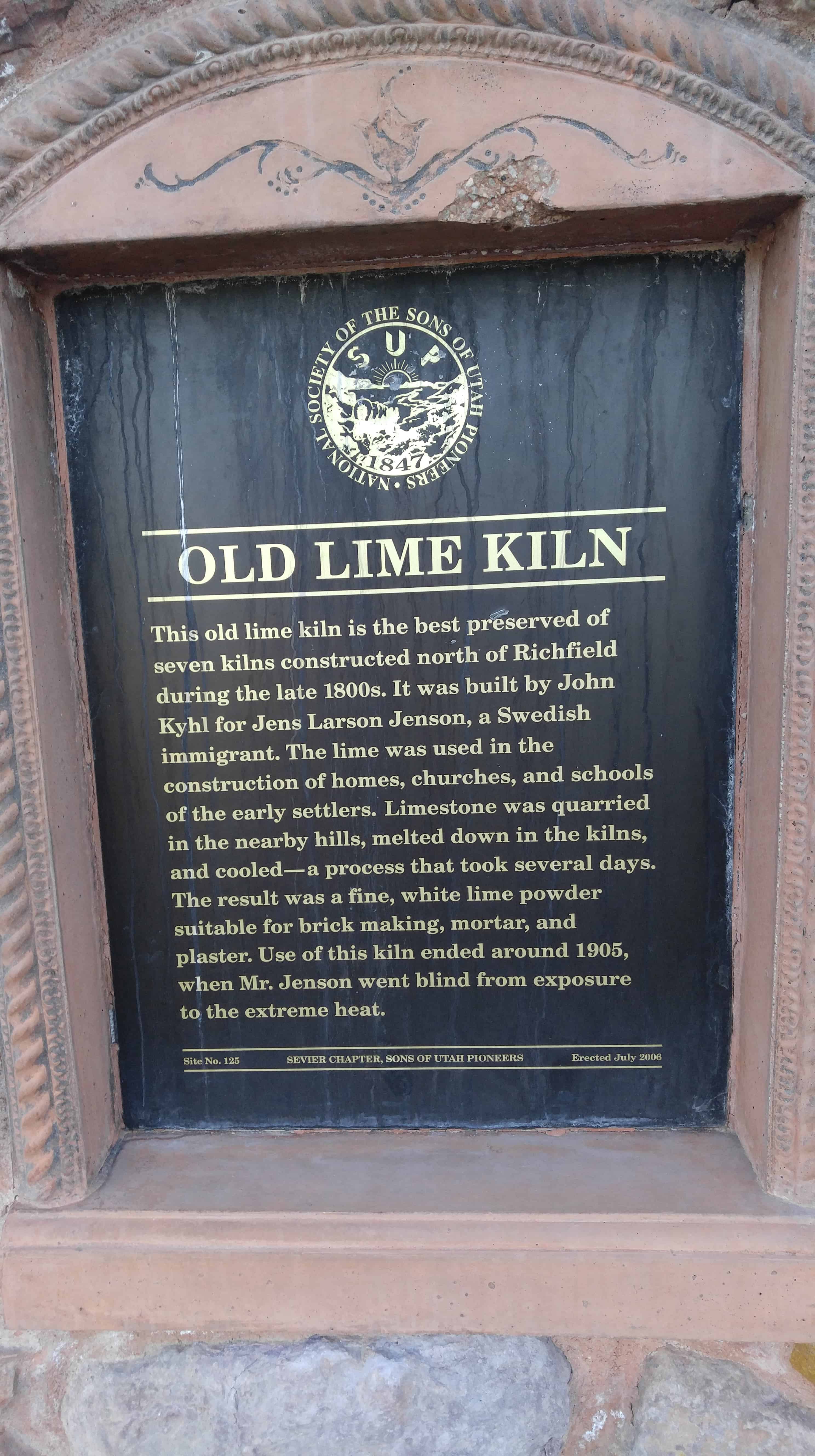
| 125 | Old Lime Kiln | Richfield, Sevier, Utah | Distant Close up | N 38.793444 W 112.085556 |
| 126/128 | Historic Covered Wagon Display | Shelley, Bingham, Idaho | N 43.37200 W 112.16695 | |
| 127 | Historic Covered Wagon Display | Shelley, Bingham, Idaho | N 43.37200 W 112.16695 | |
| 128 | The Kington Fort-Morrisite War Site | South Weber, Davis, Utah | Distant Close up | N 41.14677 W 111.96884 |
| 129 | This is the Place Restored Monument | Salt Lake City, Salt Lake, Utah | Photo | N 40.75316 W 111.81333 |
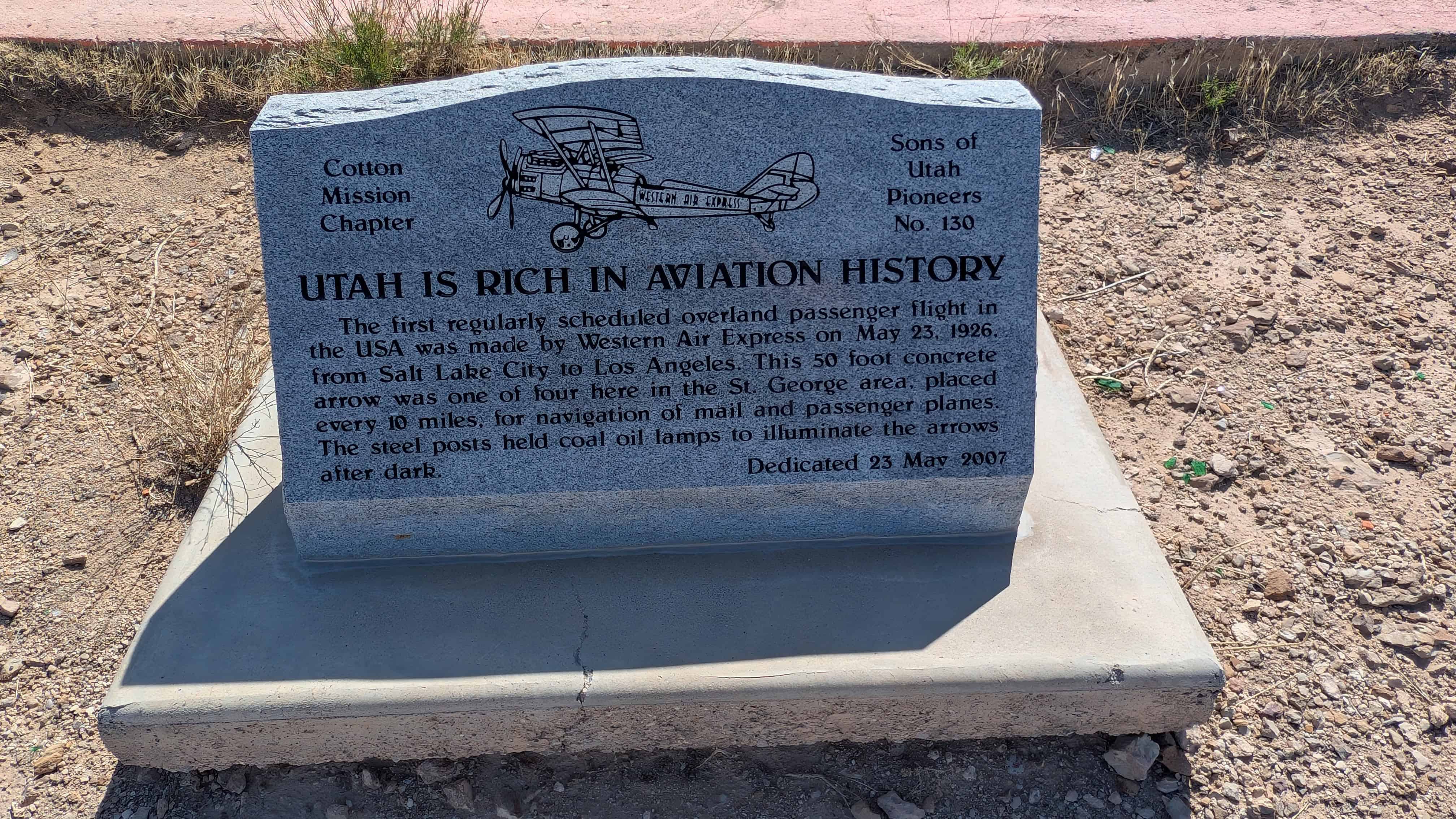
| 130 | Utah is Rich in Aviation History | St. George, Washington, Utah | Distant Close up | N 37.06482 W 113.59542 |
| 131 | Sawmill Road | Monroe, Sevier, Utah | Distant Close up | N 38.62840 W 112.12834 |
| 132 | Welsh Settlement | Taylorsville, Salt Lake, Utah | Distant Close up | N 40.67437 W 111.90845 |
| 133 | Original Pioneer Settlers of Weber County | Ogden, Weber, Utah | Distant Close up | N 41.21950 W 111.97110 |
| 134 | Southern Exploring Company 1849 Parley P. Pratt Southern Utah Expedition | Hurricane, Washington, Utah | North end of Main Street | |
| 135 | Parley P. Pratt – Southern Exploring Company, 1849 | La Verkin, Washington, Utah | Far west end of Center Street | |
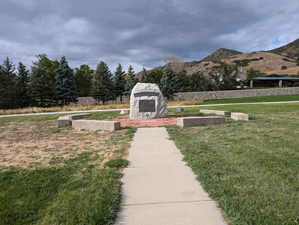
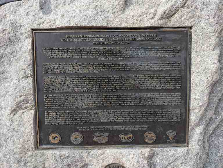
| 136 | 1997 Sesquicentennial Trekkers | Salt Lake City, Salt Lake, Utah | Distant Close up | N 40.70849 W 111.80177 |
| 137 | Wilford Woodruff’s Farm 1850 | Salt Lake City, Salt Lake, Utah | Distant Close up | N 40.73455 E 248.12312 |
| 138 & UPTLA64 & SUPK | Pioneer Flour Mill Site | Holladay, Salt Lake, Utah | Distant Close up | N 40.69662 W 111.81517 |
| 139 | The History of the Lehi Sugar Factory | Lehi, Utah, Utah | Distant Close up | N 40.69662 W 111.81517 |
| 140 | Eyes Westward | Salt Lake City, Salt Lake, Utah | Distant Close up | N 40.75238 W 111.81595 |
| 141 | A Historical Event | Escalante, Garfield, Utah | About 18 miles north of Escalante, on the mountain road to Loa. | |
| 142 | Early Morgan County Settlers | Morgan, Morgan, Utah | Distant Close up | N 41.036622 W 111.677853 |
| 143 | Emigration Canyon Monument | Salt Lake City, Salt Lake, Utah | Distant Close up | N 40.75005 W 111.81070 |
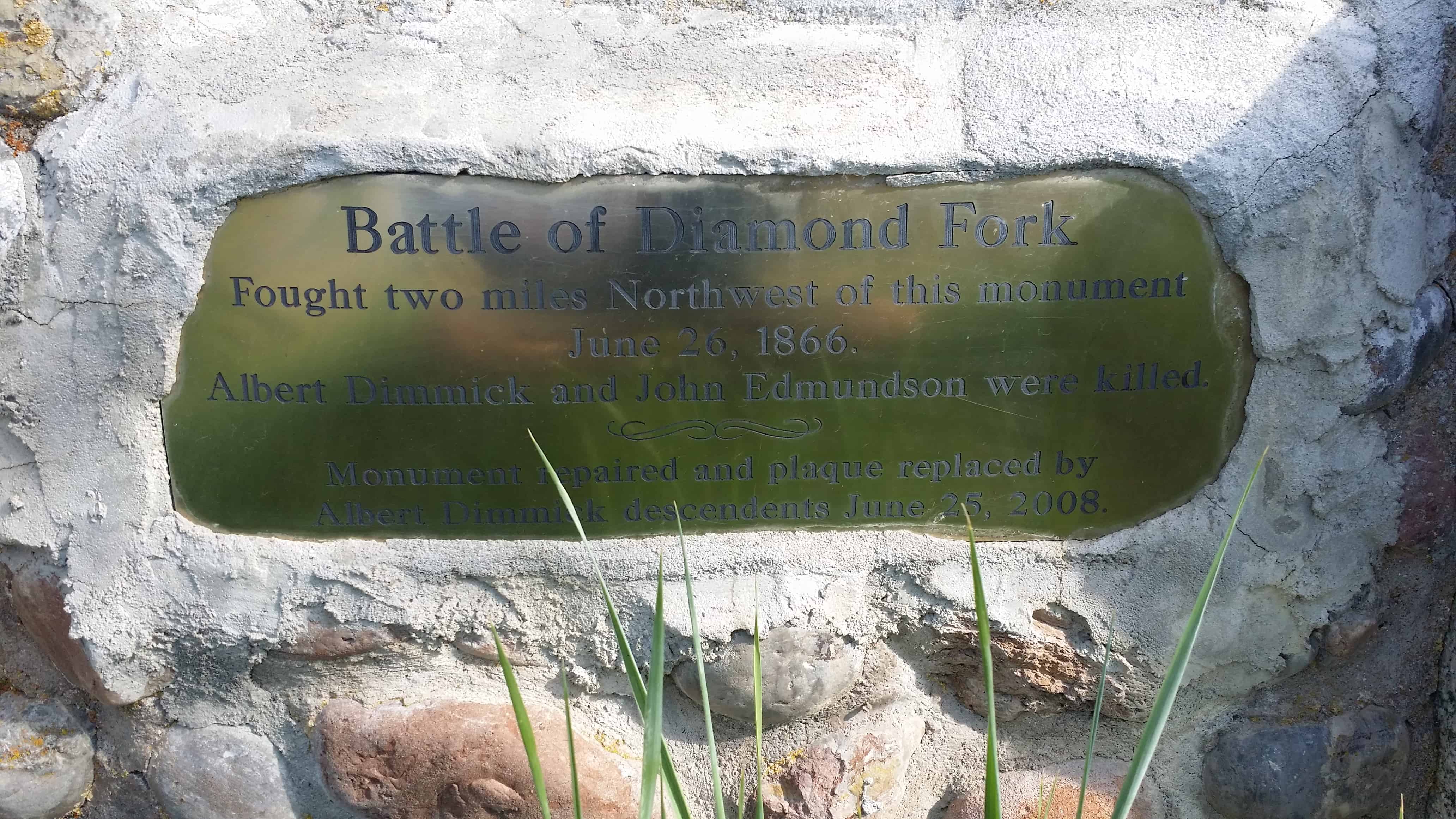
| 145 | Battle of Diamond Fork | Diamond Fork, Utah, Utah | Distant Close up | N 40.06974 W 111.43593 |
| 146 | Peace Treaty – Blackhawk War | Heber City, Wasatch, Utah | Distant Close up | N 40.51146 W 111.41142 |
| 147 | Tooele’s Mud Wall | Tooele, Tooele, Utah | Distant Close up | N 40.53073 W 112.30159 |
| 148 | Historic Brigham City Relief Society Granary | Brigham City, Box Elder, Utah | Distant Close up | N 40.53250 W 112.30159 |
| 149 | Utah Lake Fishing Industry | Provo, Utah, Utah | Distant Close up | N 40.24193 W 111.66702 |
| 150 | Bodil Mortensen Statue | Salt Lake City, Salt Lake, Utah | N 40.75294 W 111.81623 (This is the Place Heritage Park) |
|
| 151 | Joseph Allen Taylor & Chet Taylor - Innovative Farmers | Idaho Falls, Bonneville, Idaho | N 43.41009 W 111.99724 | |
| 152 | Historic Covered Wagon Display | Shelley, Bingham, Idaho | N 43.37200 W 112.16695 | |
| 153 | 1900 Baptismal Site | Taylorsville, Salt Lake, Utah | Distant Close up | N 40.66423 W 111.93351 |
| 154 | Our Sweet Three Year Old Daughter | Holladay, Salt Lake, Utah | Distant Close up | N 40.66272 W 111.83102 |
| 155 | Early Morgan Pioneers | Morgan, Morgan, Utah | Distant Close up | N 41.04065 W 111.67484 |
| 156 | Russon & Peck Immigration | Lehi, Utah, Utah | Distant Close up | N 40.39906 W 111.82462 |
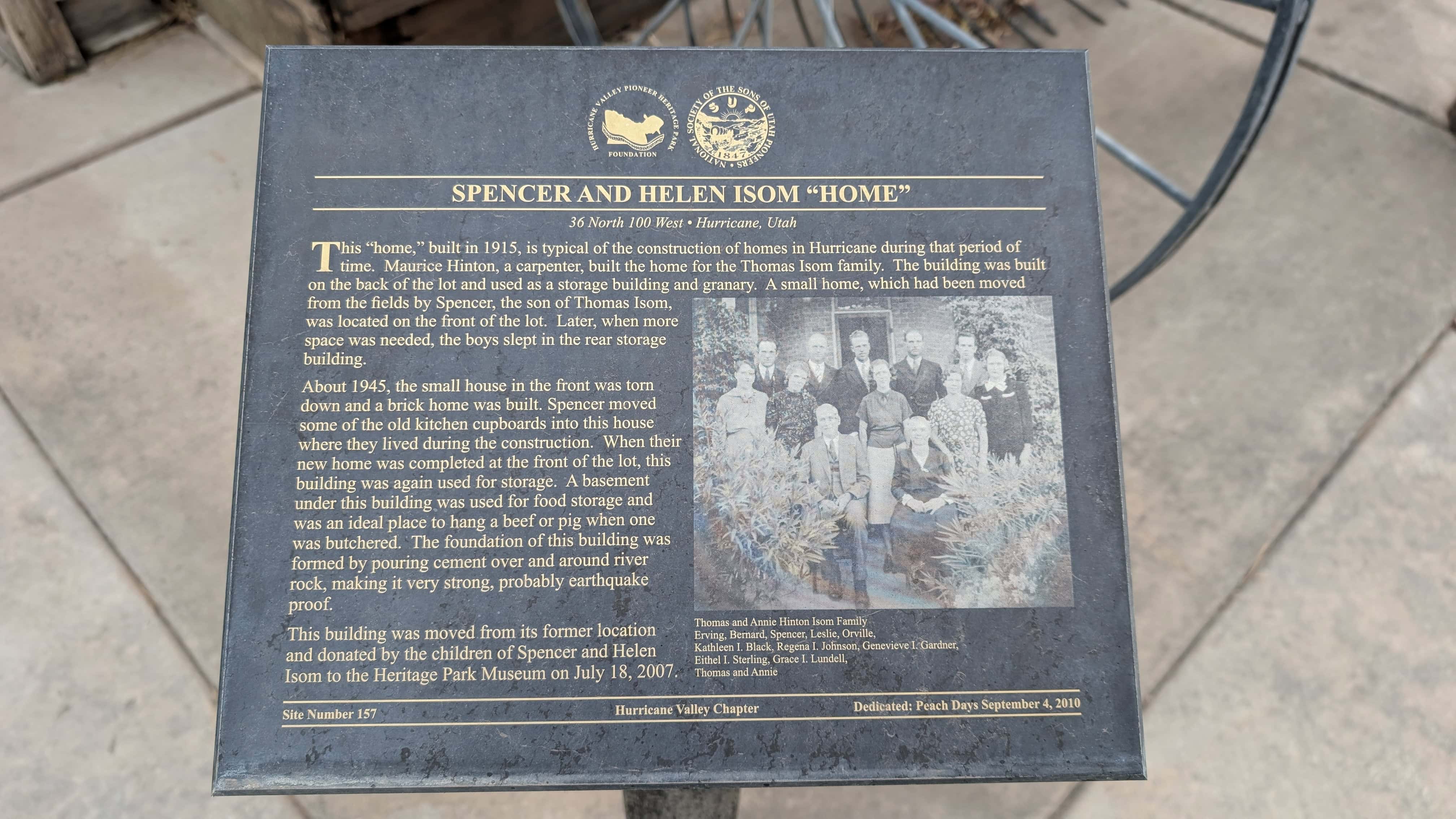
| 157 | Spencer and Helen Isom "Home" | Hurricane, Washington, Utah | Distant Close up | N 37.17524 W 113.28750 |
| 158 | Hornet Hill Monument | Kolob, Washington, Utah | N 37.48959 W 113.01945 | |
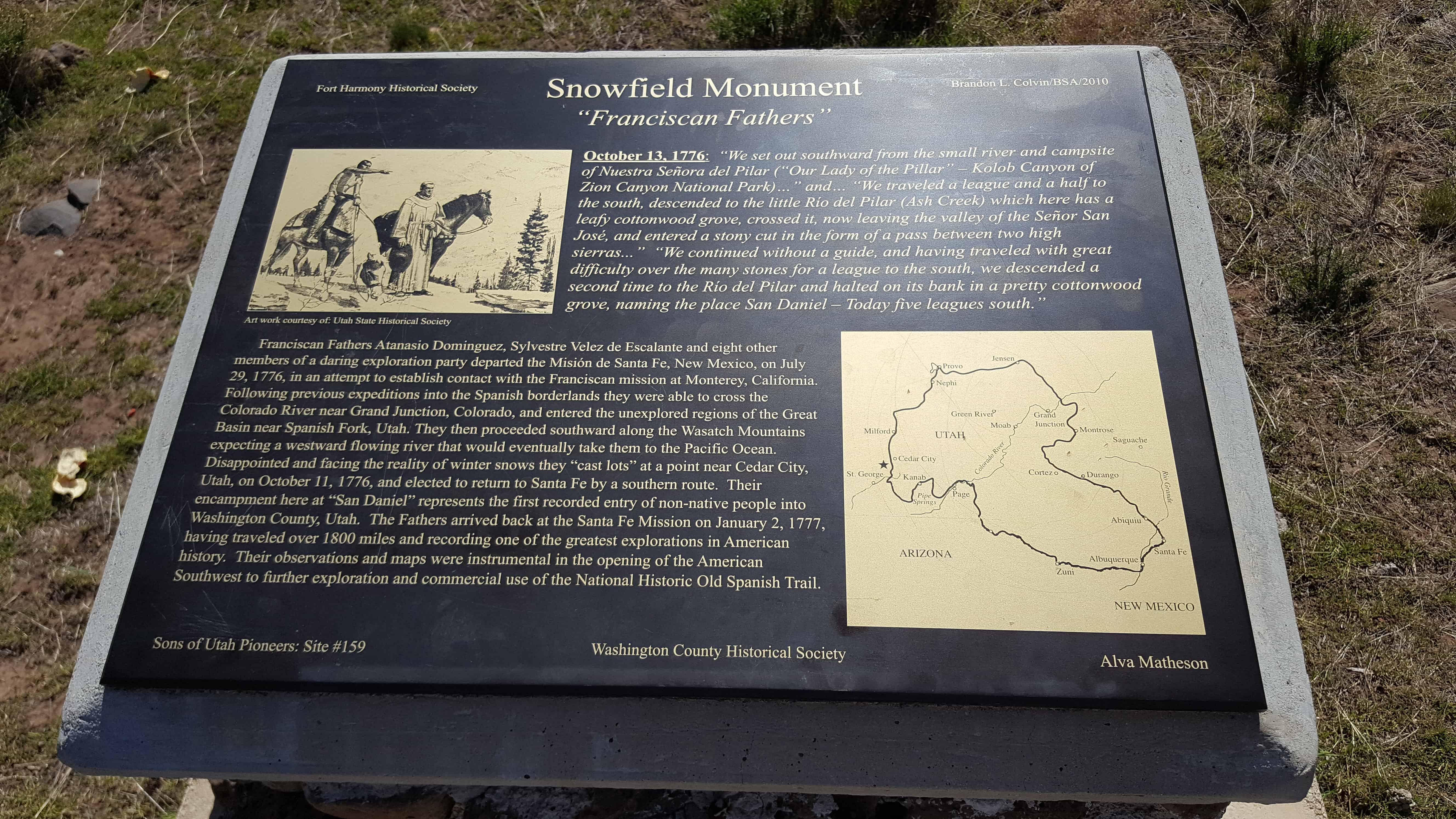
| 159 | Snowfield Monument “Franciscan Fathers” | Snowfield, Washington, Utah | Distant Close up | N 37.40502 W 113.23739 |
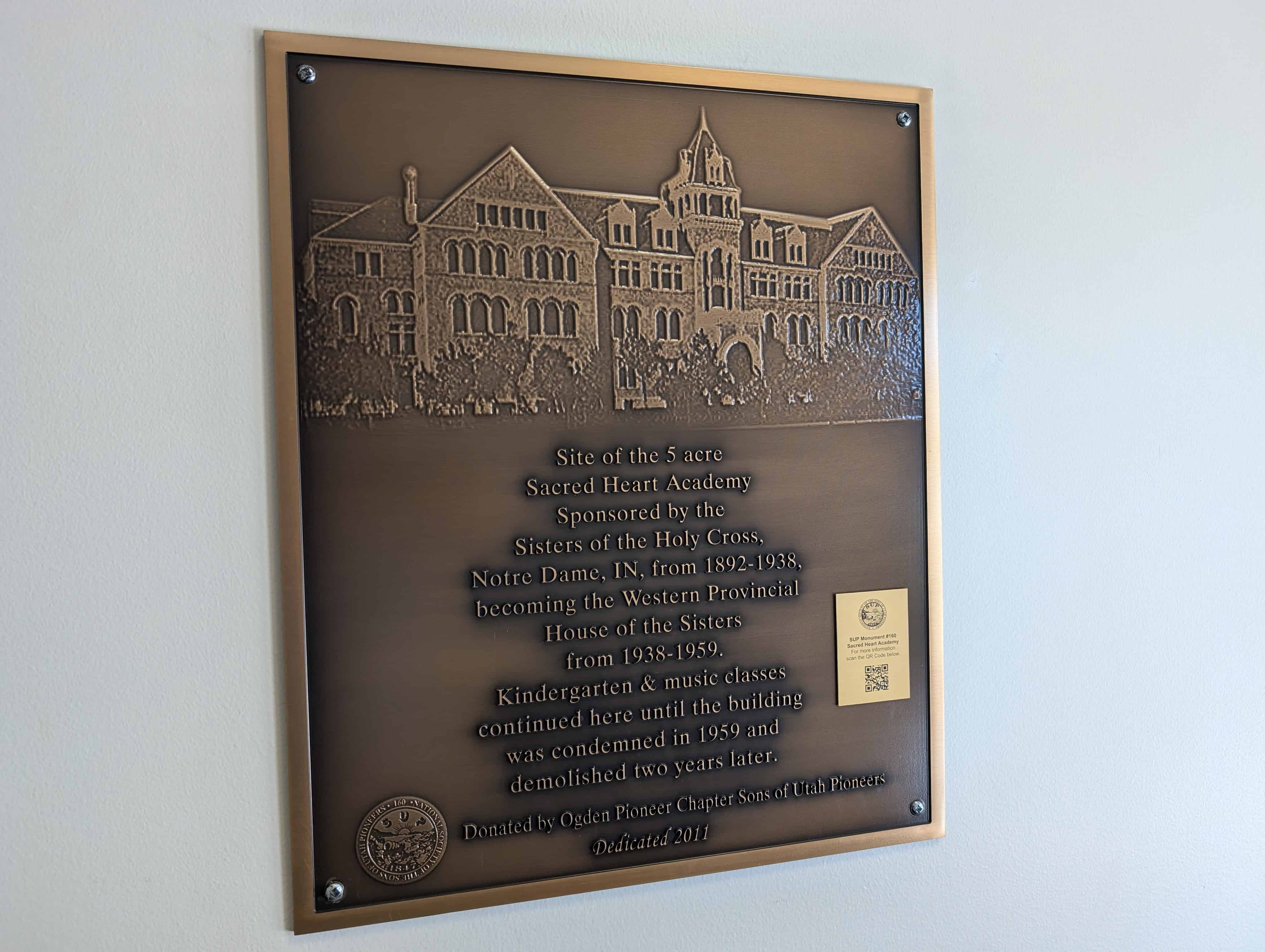
| 160 | Sacred Heart Academy | Ogden, Weber, Utah | Distant Close up | N 41.22075 W 111.95471 |
| 161 | Rexburg Public Square | Rexburg, Madison, Idaho | ||
| 162 | Historic Covered Wagon Display | Shelley, Bingham, Idaho | N 43.37200 W 112.16695 | |
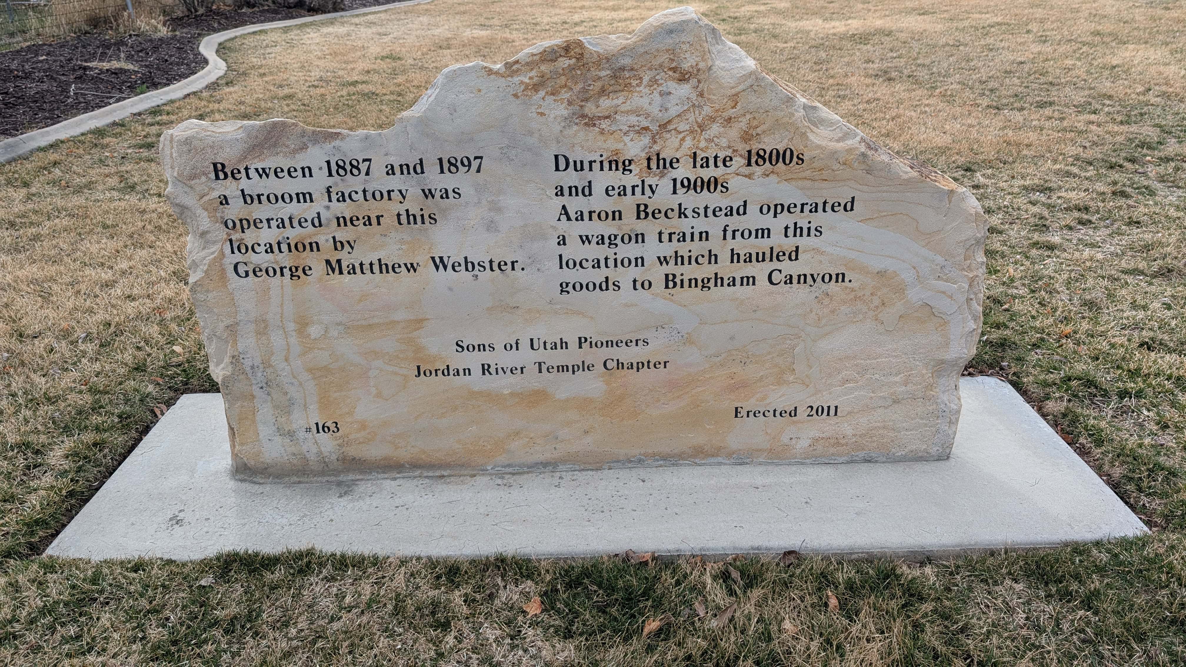
| 163 | Broom Factory and Wagon Train Terminal | Salt Lake City, Salt Lake, Utah | Distant Close up | N 40.60919 W 111.94830 |
| 164 | Harrisburg Historic Pioneer Cemetery | Harrisburg, Washington, Utah | Distant Close up | N 37.20593 W 113.39186 |
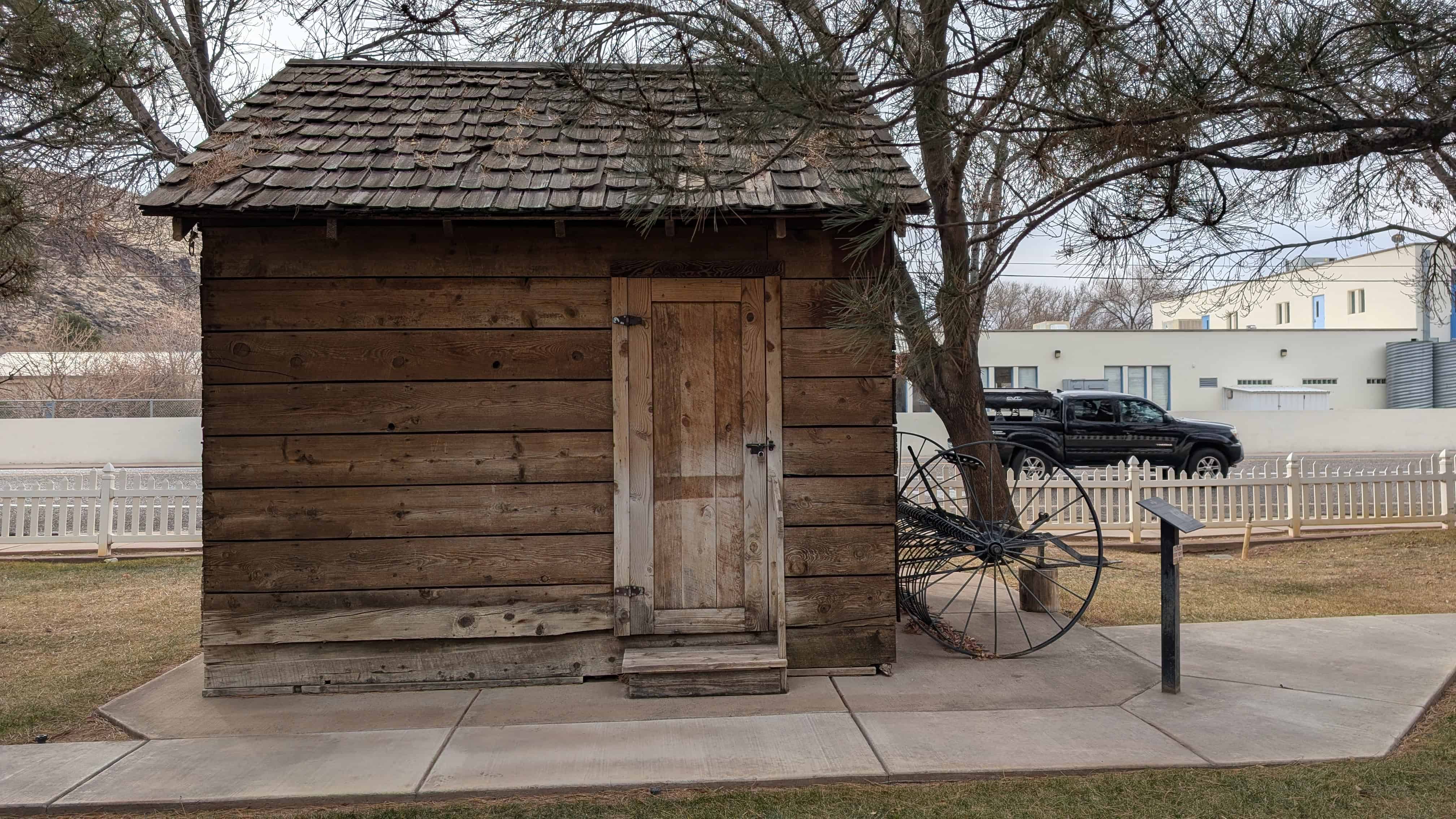
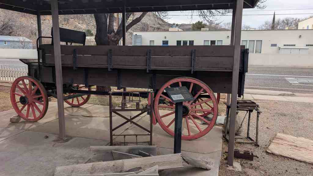
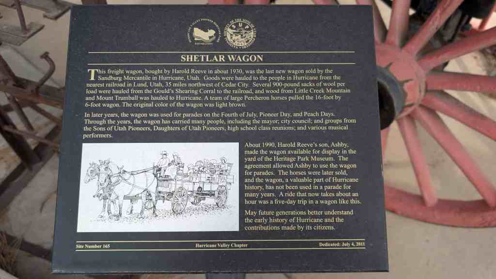
| 165 | Shetlar Wagon | Hurricane, Washington, Utah | Distant Close up | N 37.17524 W 113.28762 |
| 166 | The Town Named After a Buggy Incident | Hurricane, Washington, Utah | Hurricane Valley Heritage Park, Main and State St | |
| 167 | George A. Smith Provo Pioneer Village | Provo, Utah, Utah | Distant Close up | N 40.24193 W 111.66702 |
| 168 | Samuel R. Knight | Santa Clara, Washington, Utah | 1017 West Sunset Blvd | |
| 169 | Wilford Woodruff and Josephine Barbara Baumann Knight | Santa Clara, Washington, Utah | 1017 West Sunset Blvd | |
| 170 | Pioneer Graves Reburied | Tooele, Tooele, Utah | N 40.51666 W 112.30389 | |
| 171 | First Flour Mill | American Fork, Utah, Utah | Distant Close up | N 40.38114 W 111.79737 |
| 172 | Southern Indian Mission | New Harmony, Washington, Utah | Distant Close up | N 37.48080 W 113.24286 |
| 173 | Tonaquint | St. George, Washington, Utah | Distant Close up | N 37.07434 W 113.58291 |
| 174 | Brigham Young's Vision | St. George, Washington, Utah | Distant Close up | N 37.07423 W 113.58253 |
| 175 | The Southern Exploring Company | St. George, Washington, Utah | Distant Close up | N 37.07438 W 113.58204 |
| 176 | Jedediah Strong Smith | St. George, Washington, Utah | Distant Close up | N 37.07471 W 113.58232 |
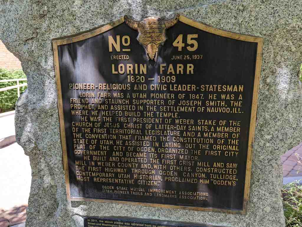
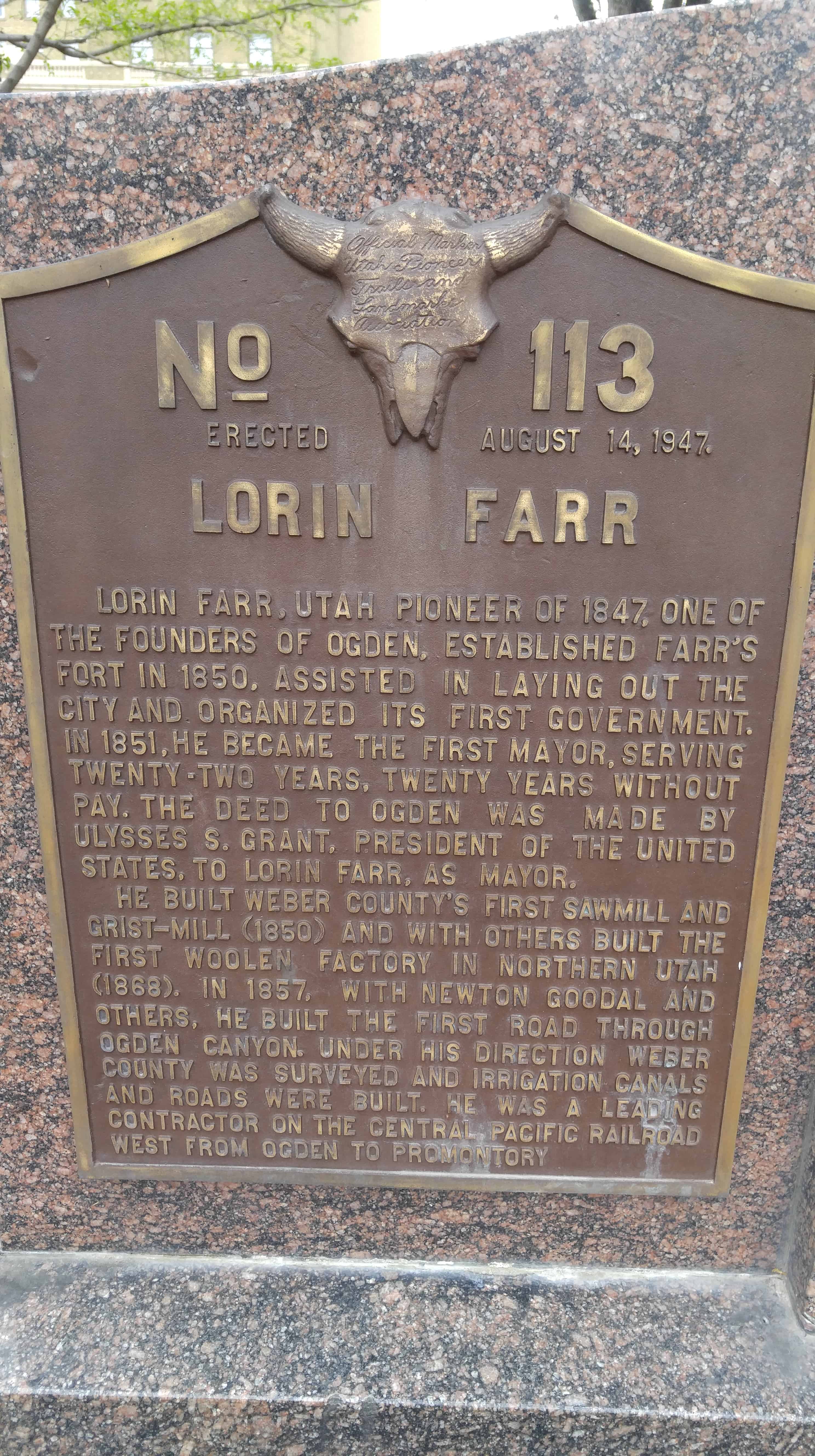
| 177 & UPTLA 45 | Lorin Farr | Ogden, Weber, Utah | Distant Close up | N 41.22880 W 111.97559 |
| 178 | The Lincoln Highway | Grantsville, Tooele, Utah | Distant Close up | N 40.60244 W 112.48232 |
| 179 | Isom’s Corner | Hurricane, Washington, Utah | Distant Close up | N 37.17641 W 113.28873 |
| 180 | Rexburg Tabernacle Centennial | Rexburg, Madison, Idaho | N 43.82701 W 111.78421 | |
| 182 | The Peter Julius Christofferson Family | Lehi, Utah, Utah | Distant Close up | N 40.40658 W 111.84005 |
| 183 | John Austin Cabin | Lehi, Utah, Utah | Distant Close up | N 40.38891 W 111.84952 |
| 184 | Major Irrigation Canals Constructed in Cache Valley | Logan, Cache, Utah | Distant Close up | N 41.74264 W 111.78764 |
| 185-A | The Utah War - U.S. Army Sent West | Echo Canyon, Summit, Utah | Distant Close up | N 40.98976 W 111.40272 |
| 185-B | The Utah War - The Mormon Response | Echo Canyon, Summit, Utah | Distant Close up | N 40.98976 W 111.40272 |
| 185-C | The Utah War - Fortifying Echo Canyon | Echo Canyon, Summit, Utah | Distant Close up | N 40.98976 W 111.40272 |
| 185-D | The Utah War - Diplomacy Prevails | Echo Canyon, Summit, Utah | Distant Close up | N 40.98976 W 111.40272 |
| 186 | Hansen Dairy | Beaver Dam, Box Elder, Utah | Distant Close up | N 41.77419 W 112.06031 |
| 187 & 51 | Little Mountain Summit | Emigration Canyon, Salt Lake, Utah | Distant Close up | N 40.77495 W 111.71830 |
| 189 | Log Cabin Grist Mill | American Fork, Utah, Utah | Distant Close up | N 40.37068 W 111.79976 |
| 190 | Wight’s Fort Cemetery | West Jordan, Salt Lake, Utah | Distant Close up | N 40.58764 W 111.97424 |
| 191 | National Woman’s Relief Society | Nauvoo, Hancock, Illinois | ||
| 192 | Leaning into the Light | Salt Lake City, Salt Lake, Utah | Distant Close up | N 40.77024 W 111.89053 |
| 193 | Flagpole at SUP Headquarters Bldg. | Salt Lake City, Salt Lake, Utah | Distant Close up | N 40.70849 W 111.80177 |
| 194 | Mormon Pioneers at Independence Rock | Independence Rock, Natrona, Wyoming | (missing?) | |
| 195 | Box Elder Academy of Music and Dancing | Brigham City, Box Elder, Utah | Distant Close up | N 41.51176 W 112.01554 |
| 196 | Box Elder Courthouse | Brigham City, Box Elder, Utah | Distant Close up | N 41.51031 W 112.01556 |
| 197 | Brigham City Gateway Arch | Brigham City, Box Elder, Utah | Distant Close up | N 41.50922 W 112.01574 |
| 198 | Brigham City Co-op Store | Brigham City, Box Elder, Utah | Distant Close up | N 41.51056 W 112.01596 |
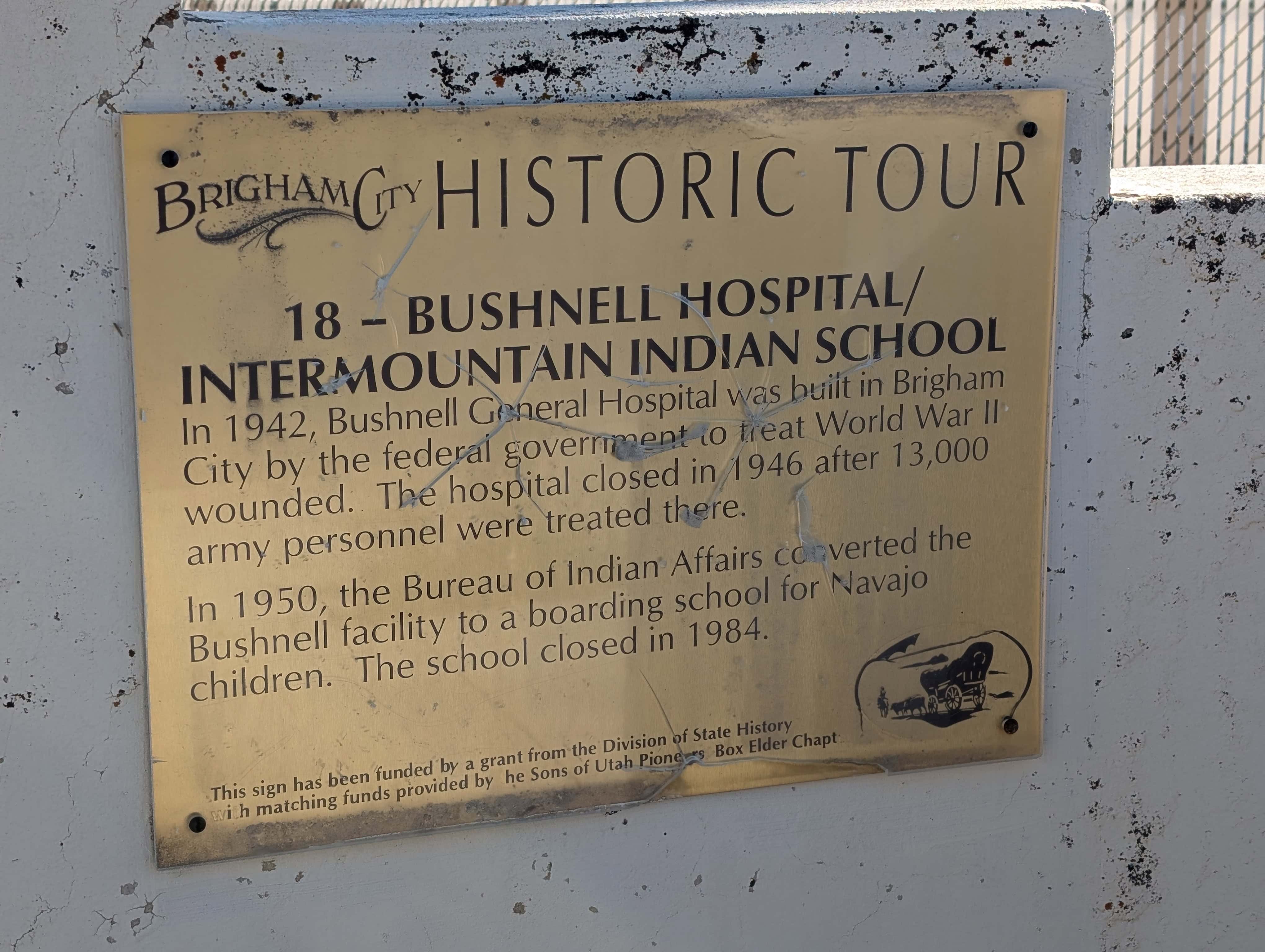
| 199 | Bushnell Hospital/Intermountain Indian School | Brigham City, Box Elder, Utah | Distant Close up | N 41.49580 W 112.01011 |
| 200 | The Davis Fort | Brigham City, Box Elder, Utah | Distant Close up | N 41.52482 W 112.02192 |
| 201 | First Ward Meeting House | Brigham City, Box Elder, Utah | Photo | N 41.50422 W 112.01401 |
| 202 | Grist Mill | Brigham City, Box Elder, Utah | Distant Close up | N 41.51486 W 112.00952 |
| 203 | Old City Hall/Fire Station | Brigham City, Box Elder, Utah | Distant Close up | N 41.51067 W 112.01558 |
| 204 | Planing Mill – Built 1875 | Brigham City, Box Elder, Utah | N 41.51048 W 112.00629 | |
| 205 | Tithing Office | Brigham City, Box Elder, Utah | Distant Close up | N 41.50904 W 112.01735 |
| 206 | Union Pacific Depot – Built 1907 | Brigham City, Box Elder, Utah | Distant Close up | N 41.51040 W 112.02930 |
| 207 | Woolen Mill - Built 1870 | Brigham City, Box Elder, Utah | N 41.51165 W 112.00775 | |
| 208 | Settlement of Provo in 1849 | Provo, Utah, Utah | Distant Close up | N 40.24138 W 111.66703 |
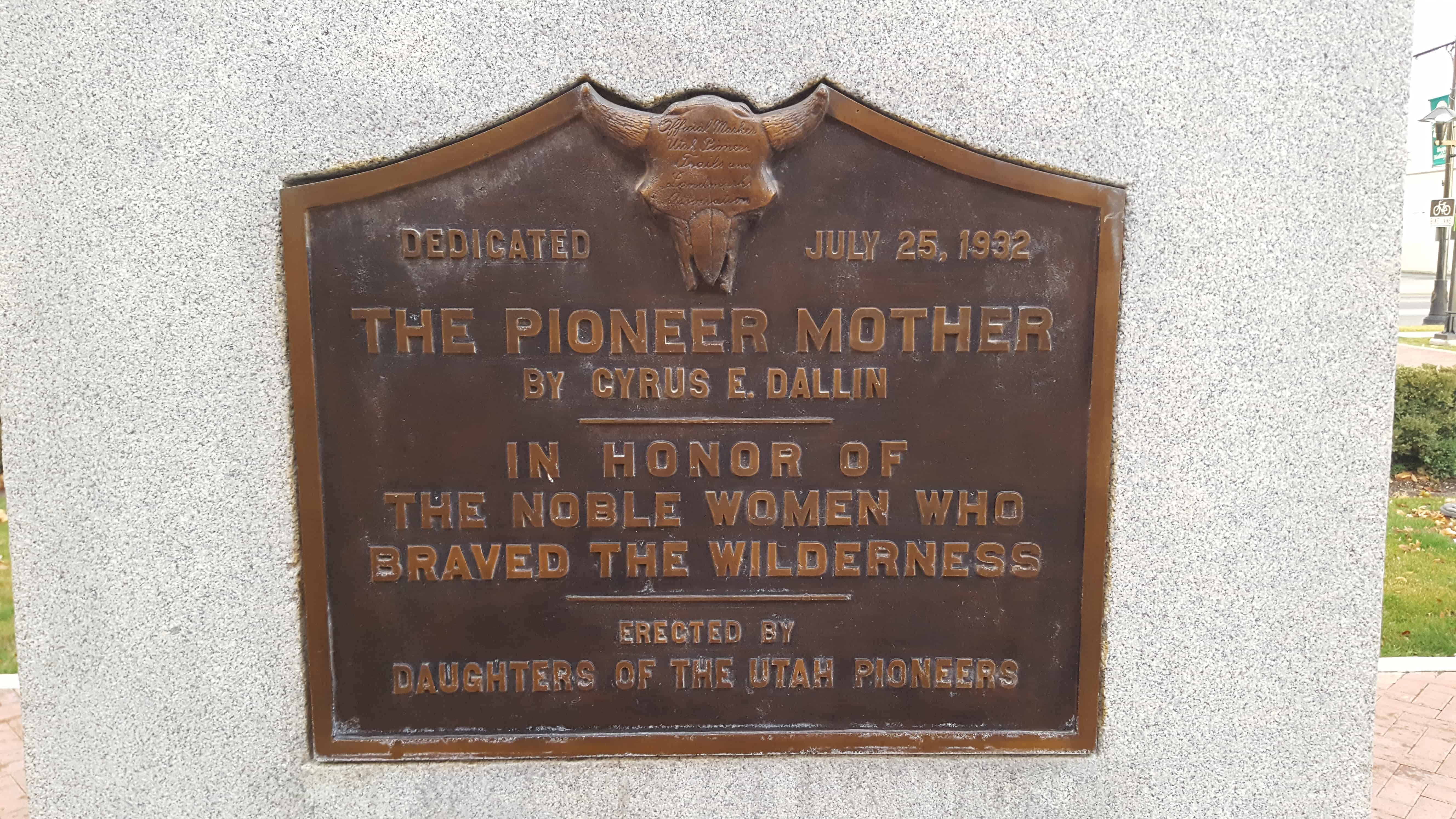
| 209 | The Pioneer Mother | Springville, Utah, Utah | Distant Close up | N 40.16517 W 111.61109 |
| 210 | Pioneer Handcart | Ogden, Weber, Utah | Distant Close up | N 41.22884 W 111.97547 |
| 211 | Bennion Ward Memorial | Taylorsville, Salt Lake, Utah | N 40.63989 W 111.94222 | |
| 212 | Honoring Servicemen | Taylorsville, Salt Lake, Utah | Distant Close up | N 40.67452 W 111.90895 |
| 213A | Blackfoot Land Office | Blackfoot, Bingham, Idaho | N 43.18872 W 112.34308 | |
| 214 | The Founding of Southern Utah University and Old Sorrel Statue | Cedar City, Iron, Utah | Distant Close up | N 37.67608 W 113.07350 |
| 215 | The Founders’ Rescue Wagon | Cedar City, Iron, Utah | Distant Close up | N 37.67556 W 113.07214 |
| 216 | Parowan Cotton Factory | Parowan, Iron, Utah | ||
| 217 | Hebron Cemetery | Hebron, Washington, Utah | N 37.59038 W 113.82541 | |
| 218 | Adair Spring | Washington, Washington, Utah | Distant Close up | N 37.13207 W 113.50646 |
| 219 | Sixty-five Mile Trail from Escalante to Hole-in-the-Rock | Escalante, Garfield, Utah | ||
| 220 | Look-Out Point | Hurricane, Washington, Utah | 50 North 100 West | |
| 221 | Trailhead and Pavilion | Hurricane, Washington, Utah | ||
| 222 | Morris Wilson Memorial Park | La Verkin, Washington, Utah | Main & Center Street | |
| 223 | First Building Outside Salt Lake City for Religious & Education Instruction | Murray, Salt Lake, Utah | Distant Close up | N 40.67891 W 111.88433 |
| 224 | Mormon Pioneer Trail, Centennial Trekkers | Salt Lake City, Salt Lake, Utah | Distant Close up | N 40.70849 W 111.80177 |
| 225 | Nathanial (Nathan) Hawk | Coloma, El Dorado, California | N 38.79440 W 120.88924 | |
| 226 | Mormon Worker's Cabin: Gold Discovery Site | Coloma, El Dorado, California | N 38.80148 W 120.89235 | |
| 230 | Donner Hill | Salt Lake, Salt Lake, Utah | Distant Close up | N 40.75166 W 111.80095 |
| 235 | Lookout Station | Vernon, Tooele, Utah | Distant Close up | N 40.11968 W 112.57649 |
| 236 | Blackrock Station | Blackrock Station, Juab, Utah | Distant Close up | N 39.87807 W 113.27152 |
| 237 | Fish Springs Station | Fish Springs, Juab, Utah | Distant Close up | N 39.84803 W 113.41084 |
| 238 | Burnt Station | Ibapah, Tooele, Utah | Distant Close up | N 40.07680 W 113.84556 |
| 239 | Burial Plot | Vernon, Tooele, Utah | Distant Close up | N 40.11865 W 112.57768 |
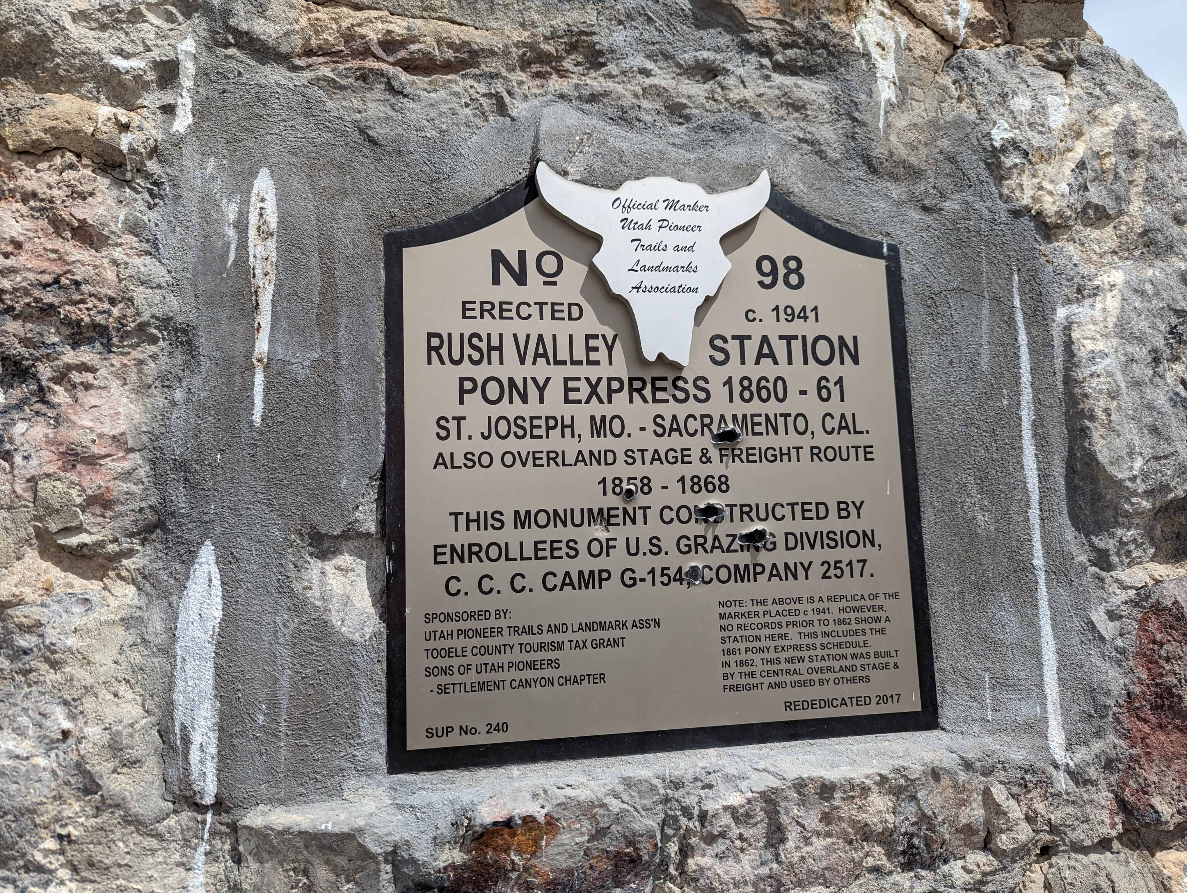
| 240 | Rush Valley Station | Rush Valley, Tooele, Utah | Distant Close up | N 40.20646 W 112.29321 |
| 242 | Tooele Carnegie Free Public Library | Tooele, Tooele, Utah | Distant Close up | N 40.53071 W 112.29720 |
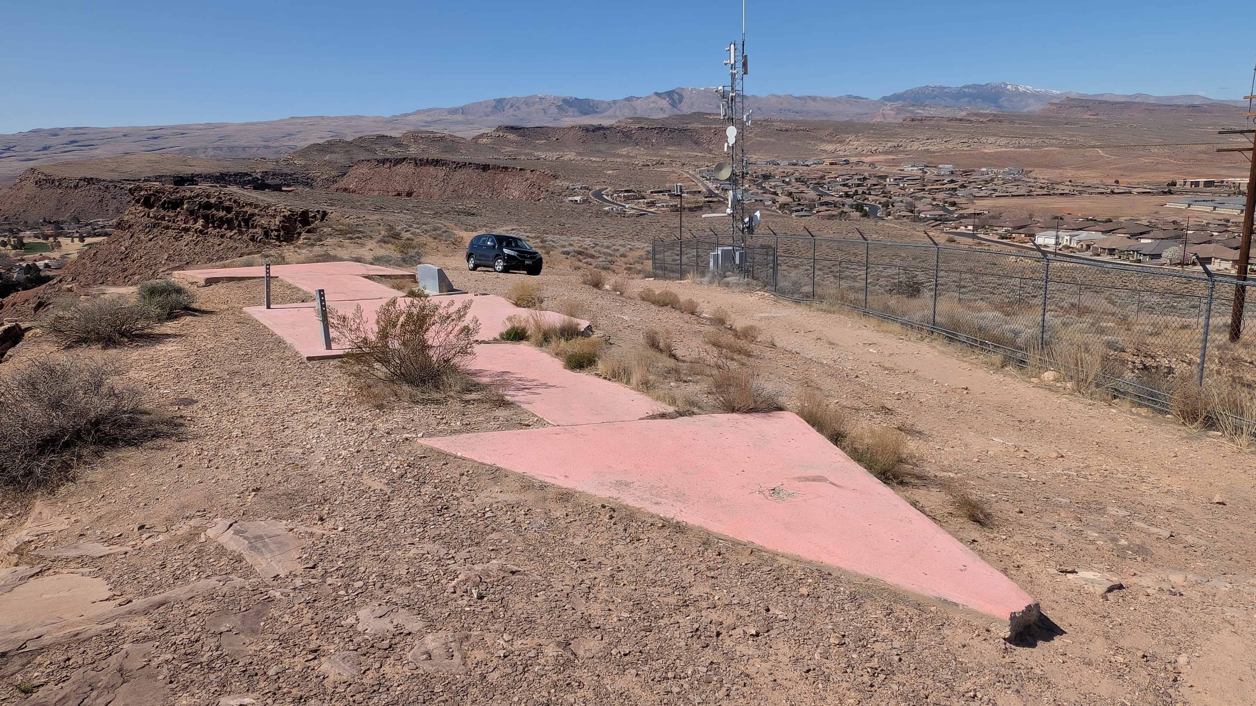
| 243 | Tooele County Airmail Arrows and Beacons | Stockton, Tooele, Utah | Distant Close up | N 40.45164 W 112.36279 |
| 246 | Civil War Skirmish at Pleasant Grove | Pleasant Grove, Utah, Utah | Distant Close up | N 40.36197 W 111.73862 |
| 249 | James Lynn Bevan | Tooele, Tooele, Utah | Distant Close up | N 40.53079 W 112.29732 |
| 276 | Soft-Rock | Pleasant Grove, Utah, Utah | Distant Close up | N 40.36207 W 111.73863 |
| 277 | ||||
| 278 | ||||
| 279 | ||||
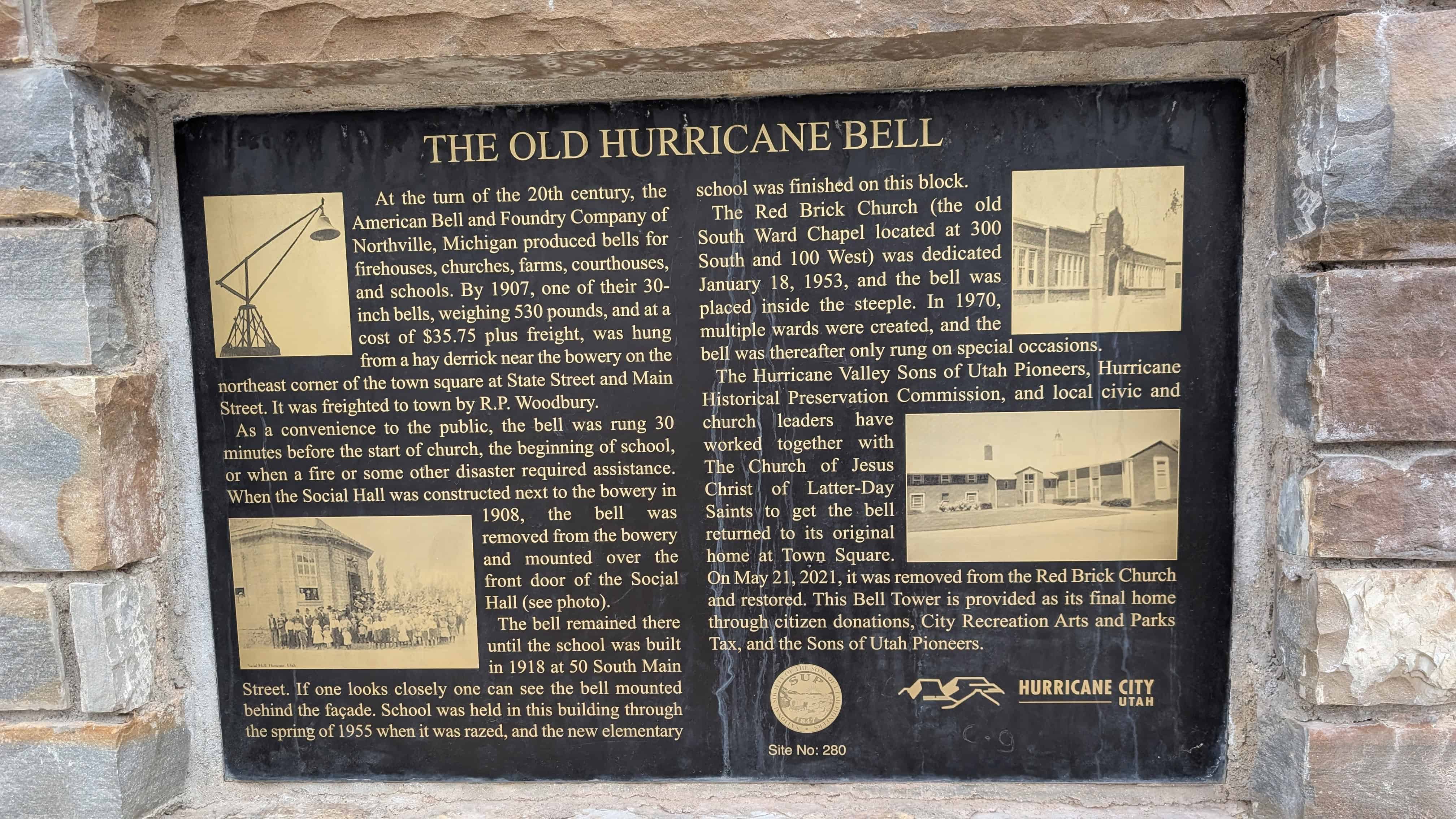
| 280 | The Old Hurricane Bell | Hurricane, Washington, Utah | Distant Close up | N 37.17619 W 113.28945 |
| 281 | ||||
| 282 | Pioneer Canal Builders of Bingham County | Blackfoot, Bingham, Idaho | N 43.18901 W 112.34417 | |
| UPTLA #1 | Escalante Trail | Provo, Utah, Utah | Distant Close up | N 40.23258 W 111.65820 |
| UPTLA #2 | Cache Valley | Logan, Cache, Utah | Distant Close up | N 41.73213 W 111.83436 |
| UPTLA #3 | Jedediah Strong Smith | Ogden, Weber, Utah | Distant Close up | N 41.22028 W 111.97108 |
| UPTLA #4 | “Mormon” Pioneer Trail | Henefer, Summit, Utah | Distant Close up | N 41.01791 W 111.49921 |
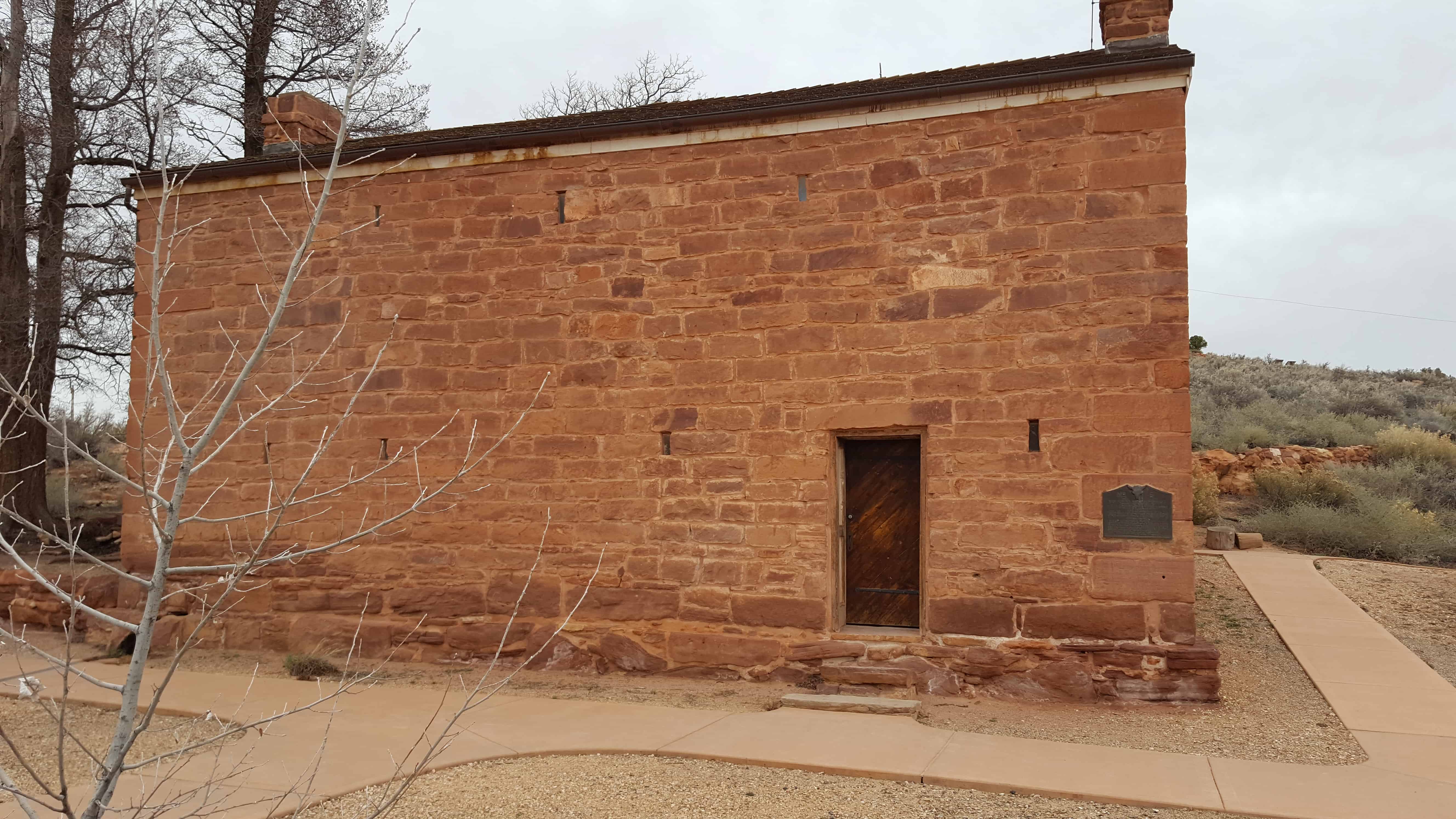
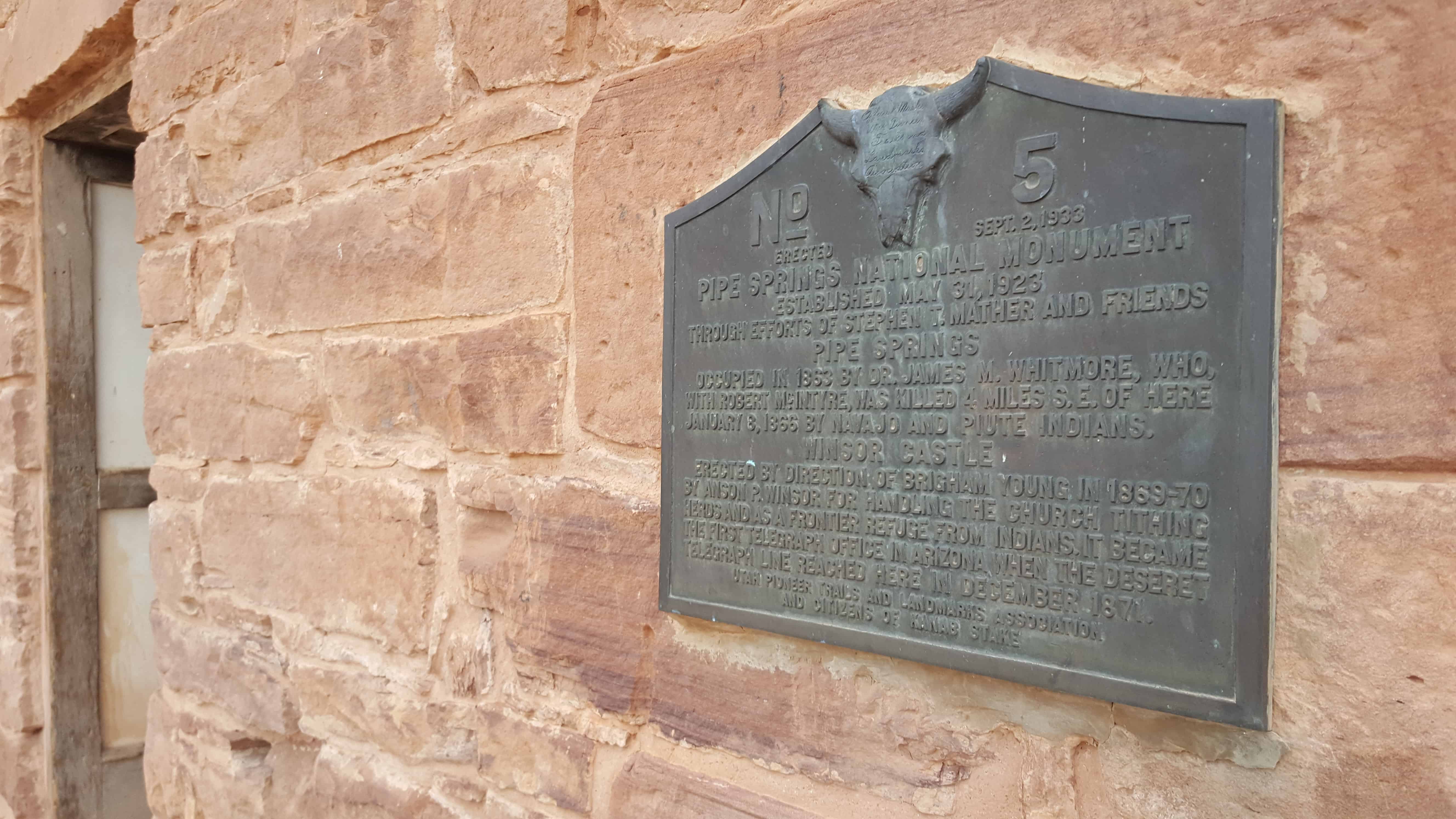
| UPTLA #5 | Pipe Springs National Monument | Pipe Springs, Coconino, Arizona | Distant Close up | N 36.86324 W 112.73948 |
| UPTLA #6 | Peace Treaty with Fish Lake Indians | Fish Lake, Sevier, Utah | Distant Close up | N 38.53610 W 111.73758 |
| UPTLA #7 | Donner Trail 1846 | Salt Lake City, Salt Lake, Utah | Distant Close up | N 40.77195 W 111.92027 |
| UPTLA #8 | Pony Express Station | Salt Lake City, Salt Lake, Utah | Distant Close up | N 40.76589 W 111.89093 |
| UPTLA #9 | The First Settlers of Logan | Logan, Cache, Utah | Distant Close up | N 41.73257 W 111.83440 |
| UPTLA #10 | In Honor of James Bridger | Bear River, Box Elder, Utah | Distant Close up | N 41.63548 W 112.12820 |
| UPTLA #11 | Fort Hall | Fort Hall, Bingham, Idaho | N 43.02471 W 112.43835 | |
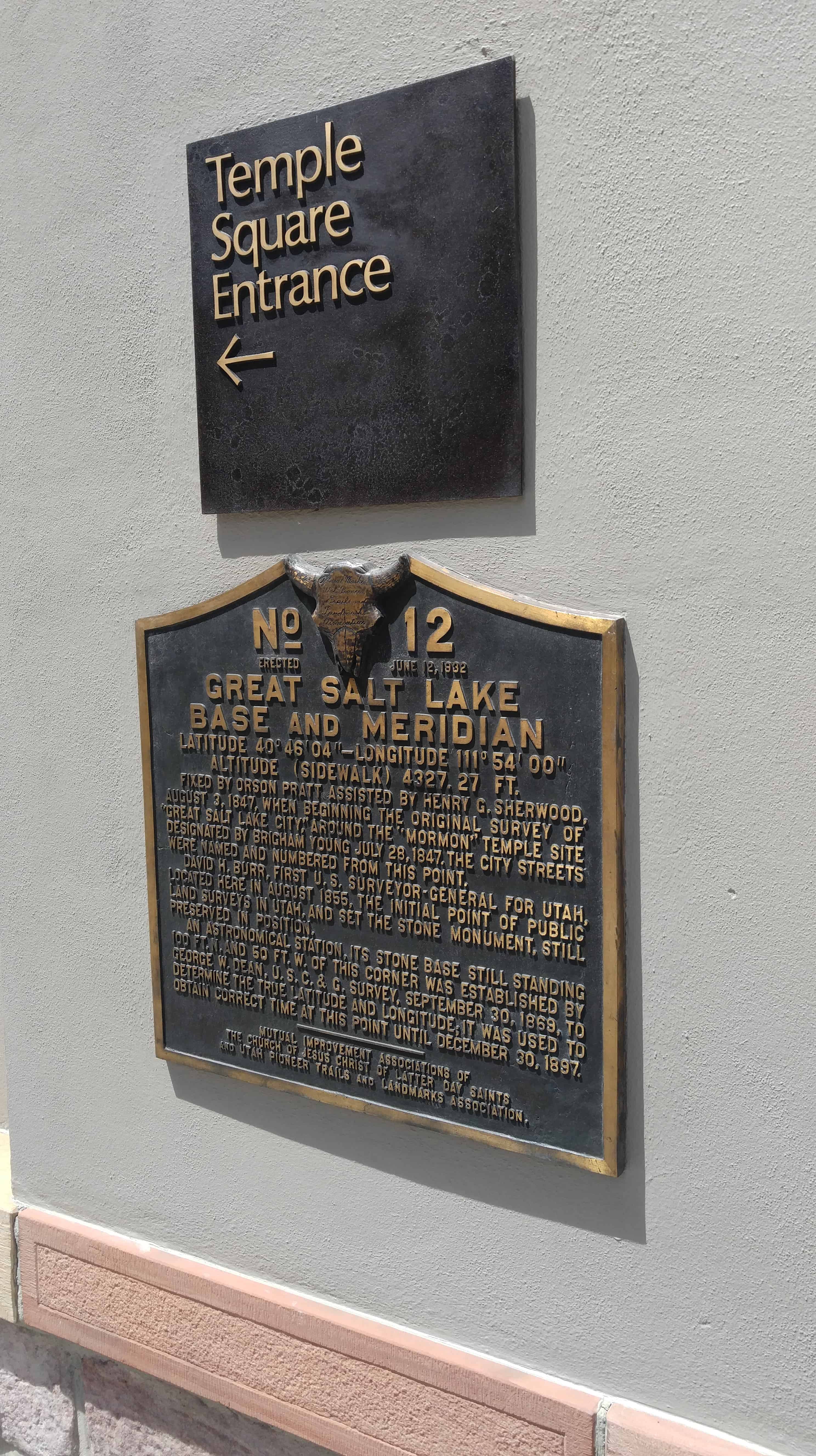
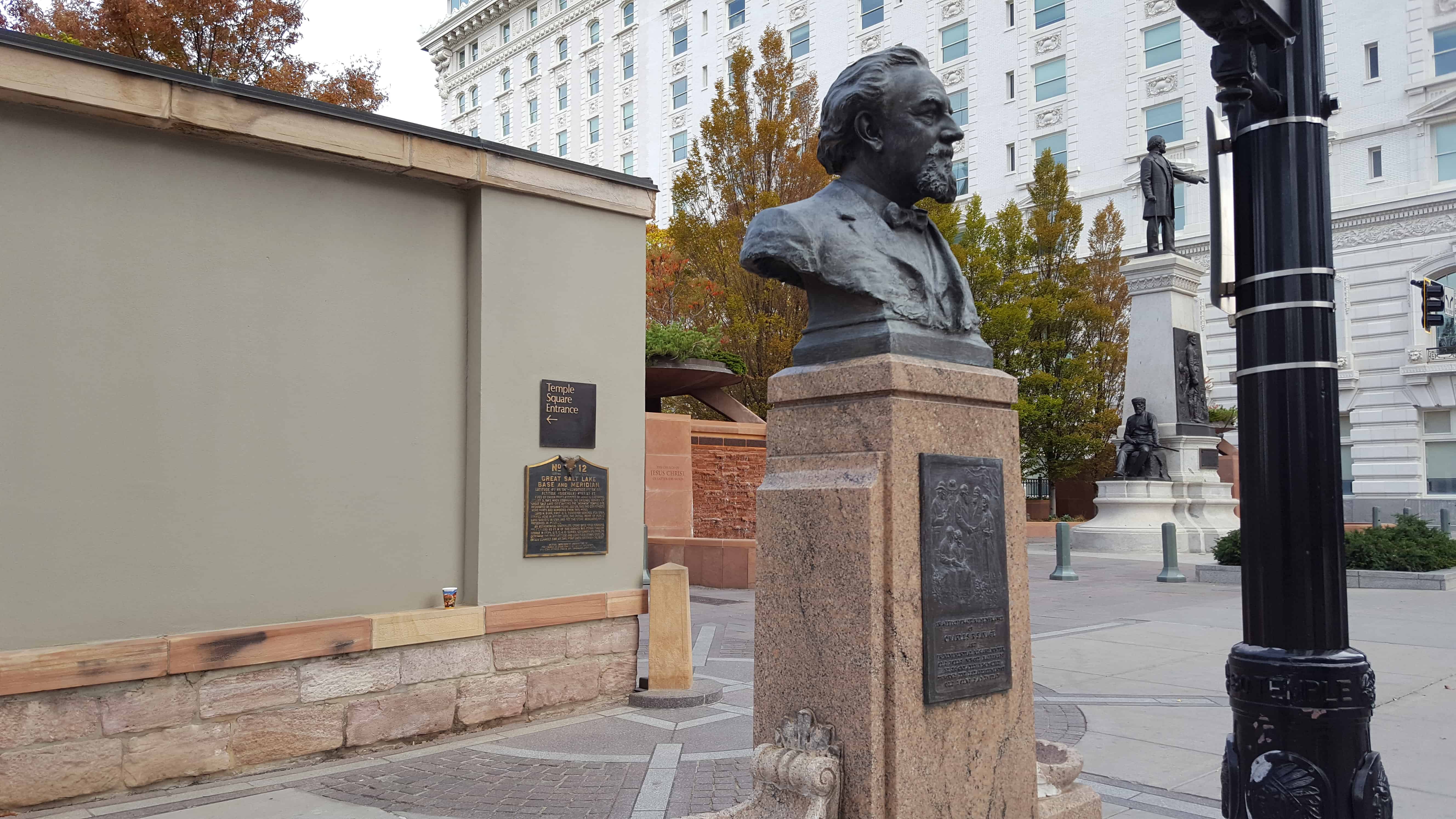
| UPTLA #12 | Great Salt Lake Base and Meridian | Salt Lake City, Salt Lake, Utah | Distant Close up | N 40.76952 W 111.89134 |
| UPTLA #13 | Mormon Ferry | Casper, Natrona, Wyoming | N 42.84474 W 106.37509 | |
| UPTLA #14 | The First Statewide Pioneer Day Celebration | Brighton, Salt Lake, Utah | Distant Close up | N 40.60357 W 111.58462 |
| UPTLA #15 | Eagle Rock Crossing | Idaho Falls, Bonneville, Idaho | N 43.49235 W 112.04472 | |
| UPTLA #16 | The Battle of Bear River | Preston, Franklin, Idaho | Distant Close up | N 42.14080 W 111.91122 |
| UPTLA #17 | Mountain Meadow Massacre | Mountain Meadow, Washington, Utah | Distant Close up | N 37.47554 W 113.64364 |
| UPTLA #18 | Sisters of the Holy Cross | Salt Lake City, Salt Lake, Utah | Distant Close up | N 40.76736 W 111.86008 |
| UPTLA #19 | In Tribute to the Utah Pioneers | Salt Lake City, Salt Lake, Utah | Distant Close up | N 40.77735 W 111.88747 |
| UPTLA #20 | The Social Hall | Salt Lake City, Salt Lake, Utah | Distant Close up | N 40.76823 W 111.88807 |
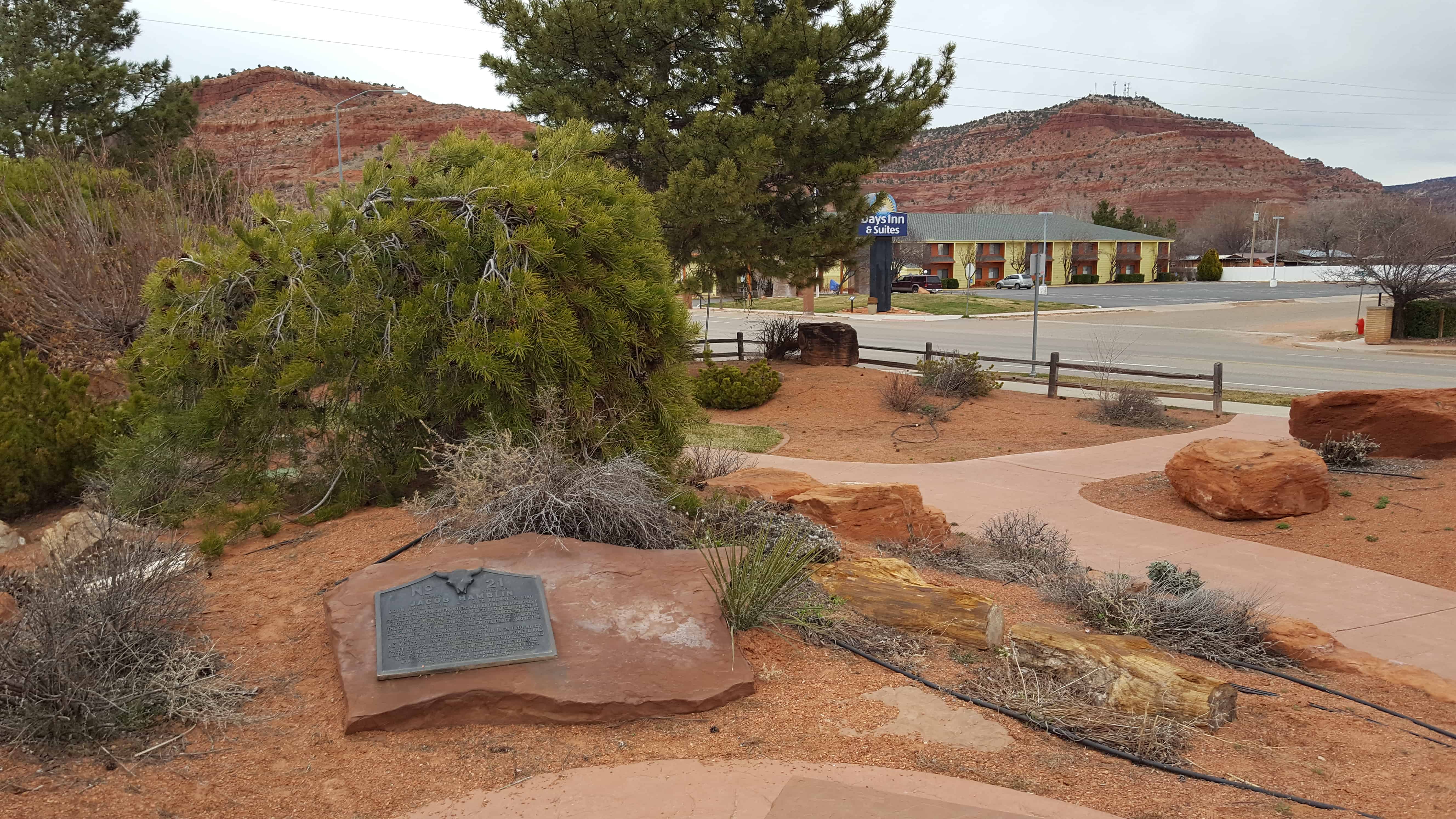
| UPTLA #21 | Jacob Hamblin | Kanab, Kane, Utah | Distant Close up | N 37.04955 W 112.53532 |
| UPTLA #22 | Call’s Fort | Honeyville, Box Elder, Utah | Distant Close up | N 41.60626 W 112.05877 |
| UPTLA #23 | Pioneer Square | Salt Lake City, Salt Lake, Utah | Distant Close up | N 40.76231 W 111.90010 |
| UPTLA #24 & SUP 3 | Big Mountain | Little Emigration Canyon, Salt Lake, Utah | Distant Close up | N 40.82793 W 111.65375 |
| UPTLA #25 | The Mormon Wall | Fort Bridger, Uinta, Wyoming | Distant Close up | N 41.31801 W 110.39316 |
| UPTLA #26 | Little Sandy Crossing | Farson, Sweetwater, Wyoming | Distant Close up | N 42.10800 W 109.45326 |
| UPTLA #27 | Willie’s Handcart Company | Rock Creek, Fremont, Wyoming | N 42.43869 W 108.62376 | |
| UPTLA #28 & SUP U | Martin’s Cove | Martin’s Cove, Natrona, Wyoming | N 42.43870 W 107.25972 | |
| UPTLA #29 | Pipe Springs National Monument | Fredonia, Coconino, Arizona | Distant Close up | N 36.94233 W 112.52607 |
| UPTLA #30 | The Old Iron Foundry | Cedar City, Iron, Utah | N 37.68211 W 113.06111 | |
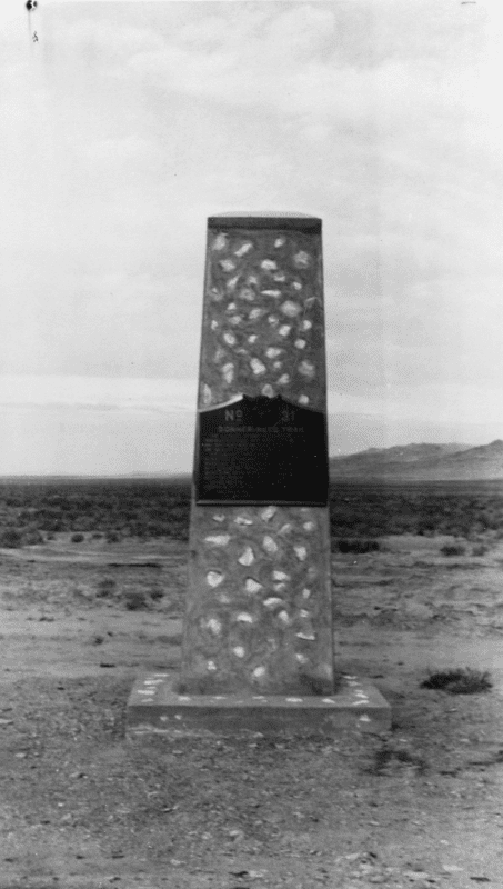
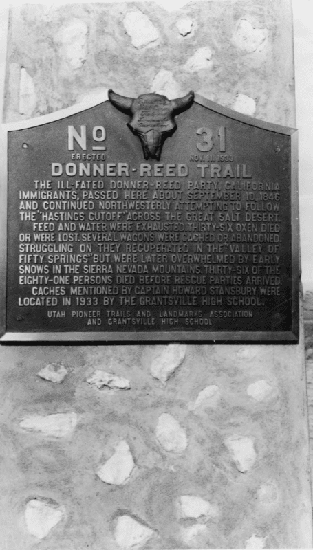
| UPTLA #31 | Donner Reed Trail | Grantsville, Tooele, Utah | Distant Close up | West of Grantsville |
| UPTLA #32 | Fort Herriman | Herriman, Salt Lake, Utah | Distant Close up | N 40.52073 W 112.03288 |
| UPTLA #33 | John C. Fremont | West Weber (Military Property), Weber, Utah | N 41.25478 W 112.23875 | |
| UPTLA #34 | Eagle Gate | Salt Lake City, Salt Lake, Utah | Distant Close up | N 40.76956 W 111.88813 |
| UPTLA #35 | A Private School House | Salt Lake City, Salt Lake, Utah | Distant Close up | N 40.76956 W 111.88813 |
| UPTLA #36 | Stage Coach Station Replaced by DUP #251 | Layton, Davis, Utah | N 41.05825 W 111.96539 | |
| UPTLA #37 | Ephraim Hank’s Pony Express Station | Mountain Dell, Salt Lake, Utah | N 40.78168 W 111.68329 | |
| UPTLA #38 | Mormon Station - Genoa | Genoa, Douglas, Nevada | N 39.00424 W 119.84579 |
|
| UPTLA #39 | Jordan Narrows | Camp Williams, Salt Lake, Utah | Distant Close up | N 40.43457 W 111.92222 |
| UPTLA #40 | Fort Henry | St. Anthony, Fremont, Idaho | N 43.96453 W 111.68181 | |
| UPTLA #41 | Miles Goodyear Cabin | Ogden, Weber, Utah | Distant Close up | N 41.22880 W 111.97559 |
| UPTLA #42 | Grantsville Fort | Grantsville, Tooele, Utah | Distant Close up | N 40.60204 W 112.47342 |
| UPTLA #43 | Ensign Peak | Salt Lake, Salt Lake, Utah | Distant Close up | N 40.79181 W 111.88824 |
| UPTLA #44 | Ogden Canyon Toll Gate | Ogden, Weber, Utah | Distant Close up | N 41.23642 W 111.92899 |
| UPTLA #45 & SUP 177 | Lorin Farr | Ogden, Weber, Utah | Distant Close up | N 41.22880 W 111.97559 |
| UPTLA #46 | Navajo County | Brigham City, Navajo, Arizona | N 35.05301 W 110.70558 | |
| UPTLA #47 | Deep Creek Station | Ibapah, Tooele, Utah | Distant Close up | N 40.02974 W 113.98681 |
| UPTLA #48 | Rockwell Station | Draper, Salt Lake, Utah | Distant Close up | N 40.48579 W 111.90532 |
| UPTLA #49 | Temple Granite Quarry | Sandy, Salt Lake, Utah | Distant Close up | N 40.57158 W 111.77451 |
| UPTLA #50 | The Bee-Hive House | Salt Lake City, Salt Lake, Utah | Distant Close up | N 40.76954 W 111.88859 |
| UPTLA #51 | The Lion House | Salt Lake City, Salt Lake, Utah | Distant Close up | N 40.76954 W 111.88900 |
| UPTLA #52 | Brigham Young’s Office | Salt Lake City, Salt Lake, Utah | Distant Close up | N 40.76953 W 111.88879 |
| UPTLA #53 & SUP W | Faust Station Pony Express | Faust, Tooele, Utah | Distant Close up | N 40.17419 W 112.42745 |
| UPTLA #54 | In Honor of the Rexburg Stake Pioneers | Rexburg, Madison, Idaho | N 43.82737 W 111.78405 | |
| UPTLA #55 | The Great Fur Cache | Hyrum, Cache, Utah | Distant Close up | N 41.63389 W 111.85598 |
| UPTLA #56 | Utah’s First Indian Battle | Pleasant Grove, Utah, Utah | Distant Close up | N 40.36157 W 111.74054 |
| UPTLA #57 | Gardner’s Saw Mill | Salt Lake City, Salt Lake, Utah | Distant Close up | N 40.69341 W 111.84857 |
| UPTLA #58 | The Mormon Colonists of the Big Horn Basin | Lovell, Big Horn, Wyoming | N 44.84155 W 108.43954 | |
| UPTLA #59 | Fort Harmony | New Harmony, Washington, Utah | Distant Close up | N 37.48050 W 113.24323 |
| UPTLA #60 | Old Irontown | Old Irontown, Iron, Utah | Distant Close up | N 37.59962 W 113.44940 |
| UPTLA #61 | Paragonah Fort | Paragonah, Iron, Utah | Distant Close up | N 37.88681 W 112.77526 |
| UPTLA #62 | Pioneer Sundial | Parowan, Iron, Utah | Distant Close up | N 37.84038 W 112.82770 |
| UPTLA #63 | First Community Center | Logan, Cache, Utah | Distant Close up | N 41.74028 W 111.82432 |
| UPTLA #64 & SUP 138 & SUP K | Pioneer Flour Mill Site | Holladay, Salt Lake, Utah | Distant Close up | N 40.69662 W 111.81517 |
| UPTLA #65 | Old Folks Day | Salt Lake City, Salt Lake, Utah | Distant Close up | N 40.76951 W 111.89134 |
| UPTLA #66 | Wallsburg Fort | Wallsburg, Wasatch, Utah | Distant Close up | N 40.38627 W 111.42257 |
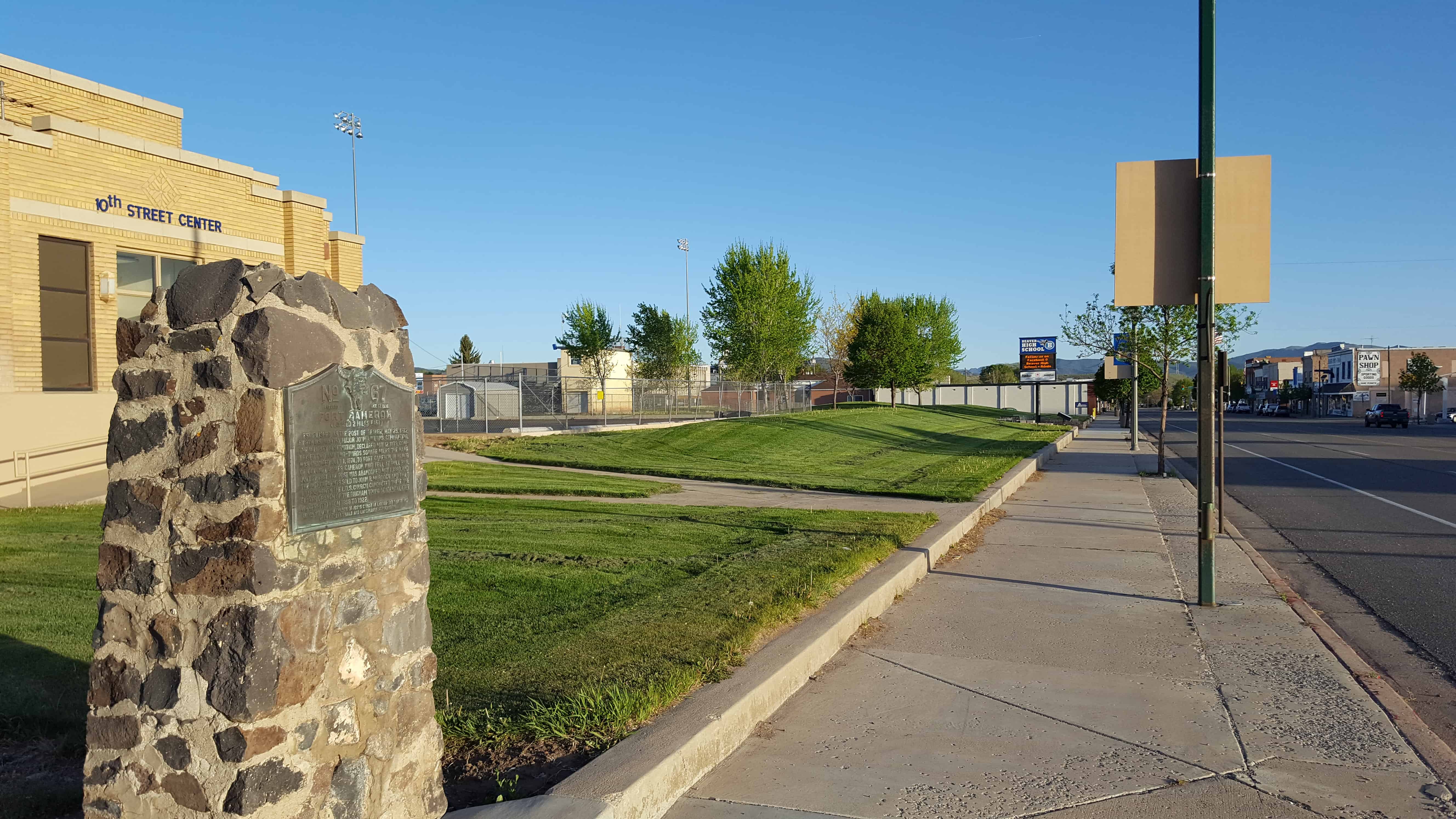
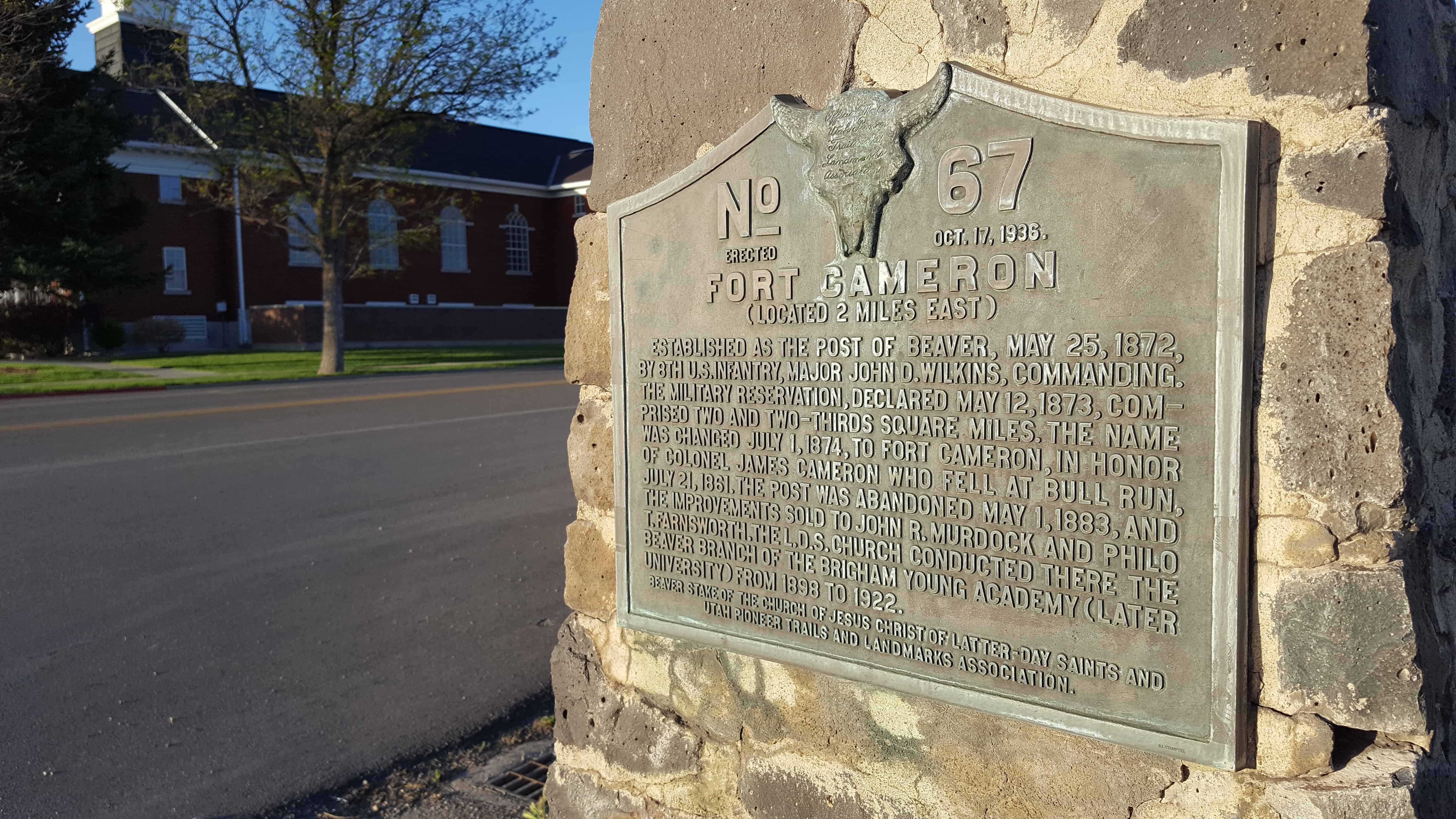
| UPTLA #67 | Fort Cameron | Beaver, Beaver, Utah | Distant Close up | N 38.27677 W 112.64111 |
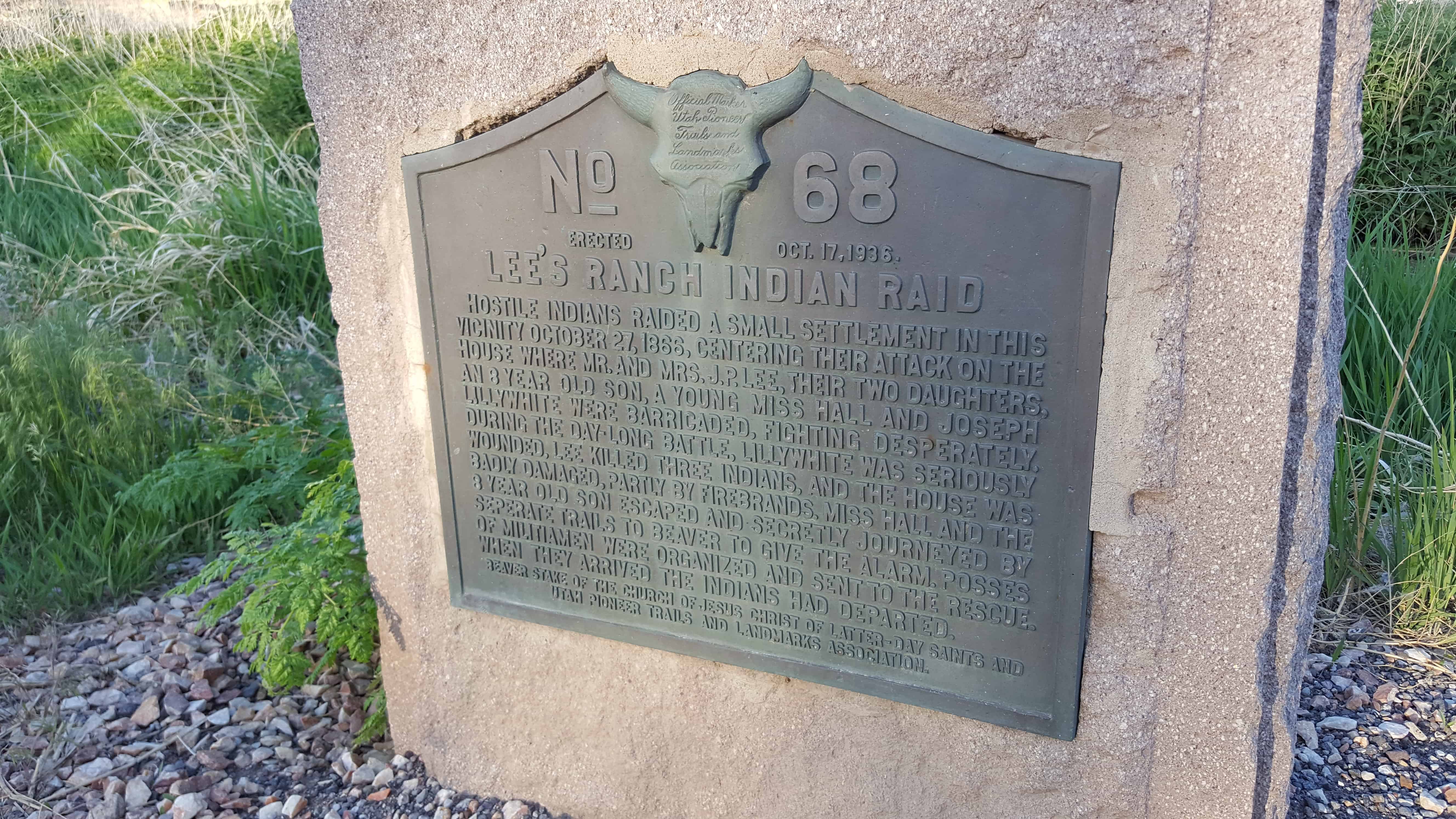
| UPTLA #68 | Lee’s Ranch Indian Raid | Brigham City, Box Elder, Utah | Distant Close up | N 38.25363 W 112.64623 |
| UPTLA #69 | Brigham Young’s Last Public Address | Brigham City, Box Elder, Utah | Distant Close up | N 41.51082 W 112.01953 |
| UPTLA #70 | Honor of The Mormon Pioneers of Idaho – Builders of North Fork (Snake River) Ferry | Burton, Madison, Idaho | N 43.82551 W 111.90577 | |
| UPTLA #71 | Mormon Battalion Trail | Picacho, Pinal, Arizona | N 32.64647 W 111.39455 ?? | |
| UPTLA #72 | Pierre – Jean De Smet | Ogden, Weber, Utah | Distant Close up | N 41.222476 W 111.964541 |
| UPTLA #73 | Charles Coulson Rich | Paris, Bear Lake, Idaho | N 42.22552 W 111.40031 | |
| UPTLA #74 | Fur Traders Rendezvous | Laketown, Rich, Utah | N 41.85714 W 111.36363 | |
| UPTLA #75 | Fort Robidoux | Fort Duchesne, Uintah, Utah | Distant Close up | N 40.30168 W 109.89240 |
| UPTLA #76 | Great Salt Lake | Saltair, Salt Lake, Utah | (missing?) | |
| UPTLA #77 | George A. Smith Jr. killed | Tonalea, Coconino, Arizona | N 36.32577 W 110.93537 | |
| UPTLA #78 | Grave of Brigham Young | Salt Lake City, Salt Lake, Utah | Distant Close up | N 40.77011 W 111.88558 |
| UPTLA #79 | Pioneer Camp | Bridgeport, Morrill, Nebraska | N 41.67968 W 103.09611 | |
| UPTLA #80 | Pioneer Camp | North Platte, Lincoln, Nebraska | N 41.16054 W 100.79100 | |
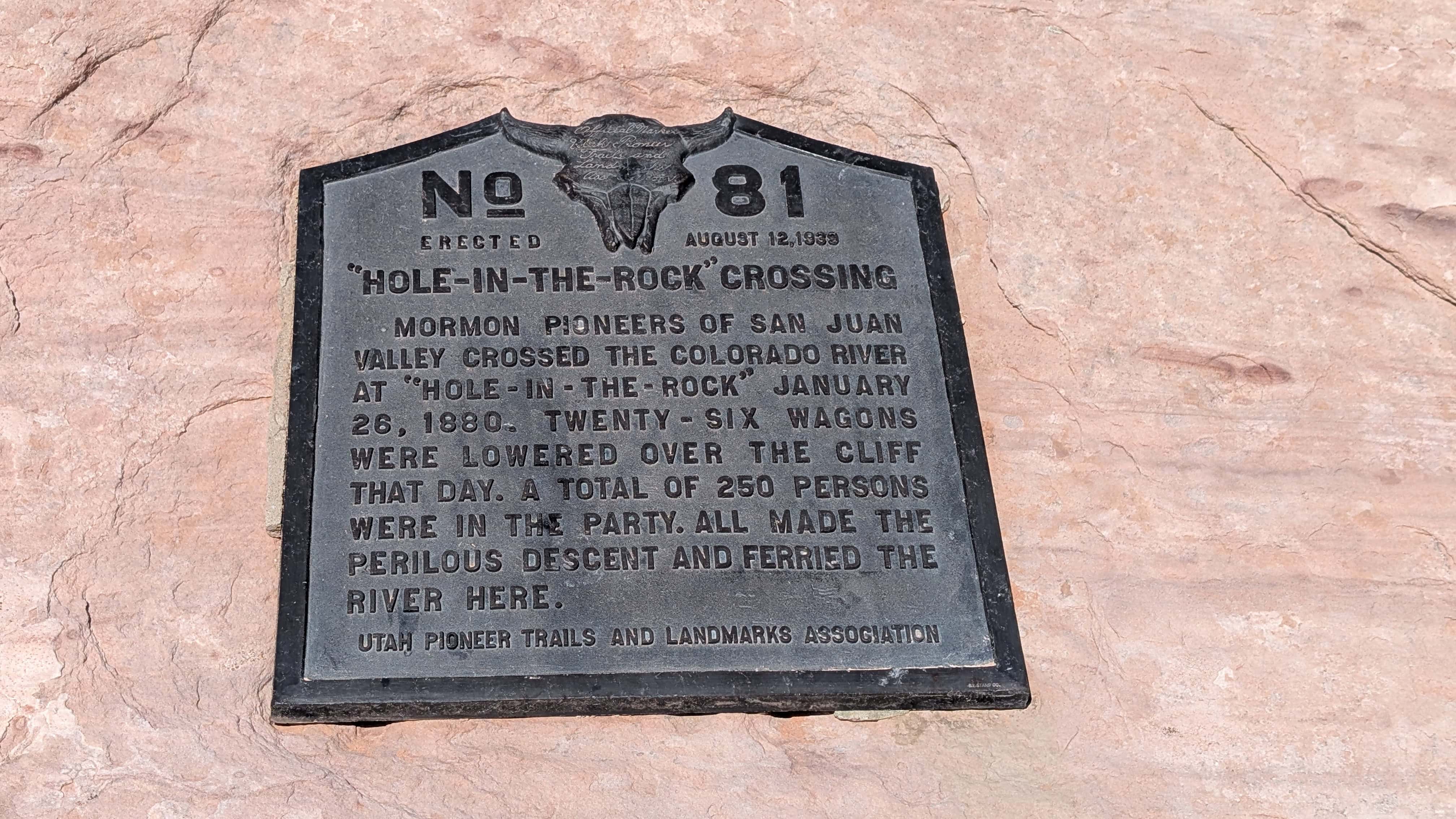
| UPTLA #81 | “Hole-In-The-Rock” Crossing | Hole-in-the-Rock, Kane, Utah | Distant Close up | N 37.25643 W 110.90030 |
| UPTLA #82 | Fairfield – Camp Floyd – Fort Crittenden | Fairfield, Utah, Utah | N 40.26050 W 112.09284 | |
| UPTLA #83 | Willow Spring Pony Express Station | Callao, Juab, Utah | Distant Close up | N 39.90027 W 113.71421 |
| UPTLA #84 | Hyde Park Settlers | Hyde Park, Cache, Utah | Distant Close up | N 41.79933 W 111.82467 |
| UPTLA #85 | Tom Polaca | Snowflake, Navajo, Arizona | N 35.89058 W 110.34834 | |
| UPTLA #86 & SUP 2 | Lookout Station | Vernon, Tooele, Utah | Distant Close up | N 40.11968 W 112.57649 |
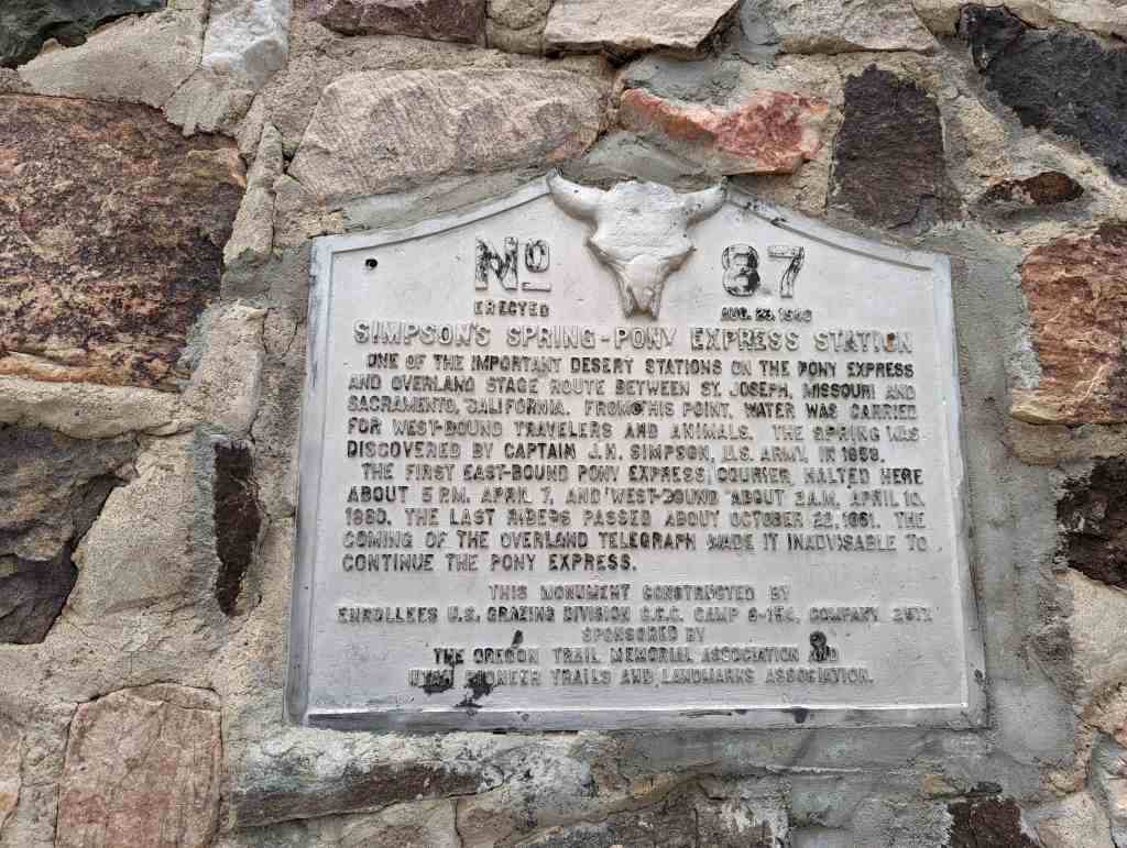
| UPTLA #87 | Simpson Spring – Pony Express Station | Simpson Springs, Tooele, Utah | Distant Close up | N 40.03946 W 112.78756 |
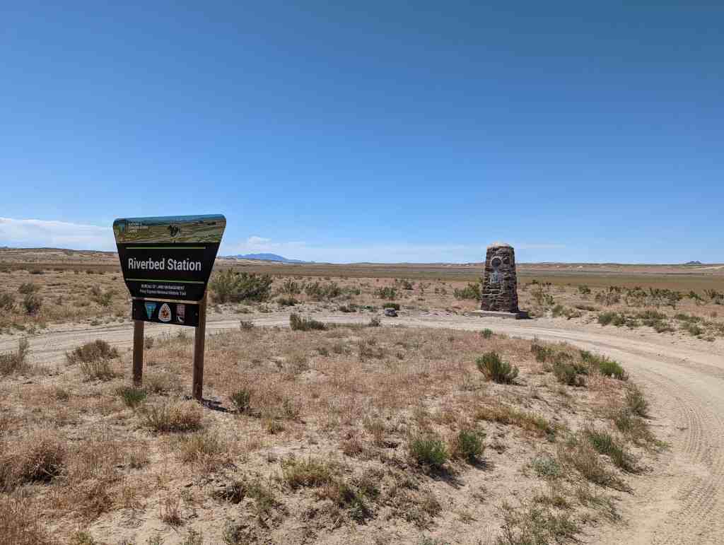
| UPTLA #88 | Riverbed Station | Simpson Springs, Tooele, Utah | Distant Close up | N 39.95990 W 112.89508 |
| UPTLA #89 | Dugway Station | Dugway Station, Juab, Utah | N 39.85797 W 113.03615 | |
| UPTLA #90 | Blackrock Station | Blackrock Station, Juab, Utah | Distant Close up | N 39.87807 W 113.27152 |
| UPTLA #91 | Fish Springs Station | Fish Springs, Juab, Utah | Distant Close up | N 39.84803 W 113.41084 |
| UPTLA #92 | Boyd Station (marker missing) | Boyd Station, Juab, Utah | Distant Close up | N 39.84375 W 113.55373 |
| UPTLA #93 | Round (Canyon) Pony Express Station | Callao, Tooele, Utah | N 40.04450 W 113.80420 | |
| UPTLA #94 | Burnt Station | Ibapah, Tooele, Utah | Distant Close up | N 40.07680 W 113.84556 |
| UPTLA #95 | Burial Plot | Vernon, Tooele, Utah | Distant Close up | N 40.11865 W 112.57768 |
| UPTLA #96 | Tuba (Tuve) Hopi Chief | Tuba City, Coconino, Arizona | N 36.13341 W 111.24040 | |
| UPTLA #97 | Steptoe's Military Camp, Godbe's Smelter | Tooele, Tooele, Utah | Distant Close up | N 40.42374 W 112.38182 |
| UPTLA #98 | Rush Valley Station | Rush Valley, Tooele, Utah | Distant Close up | N 40.20646 W 112.29321 |
| UPTLA #99 | Mormon Battalion Route | Algodones, Sandoval, New Mexico | N 35.45164 W 106.35390 | |
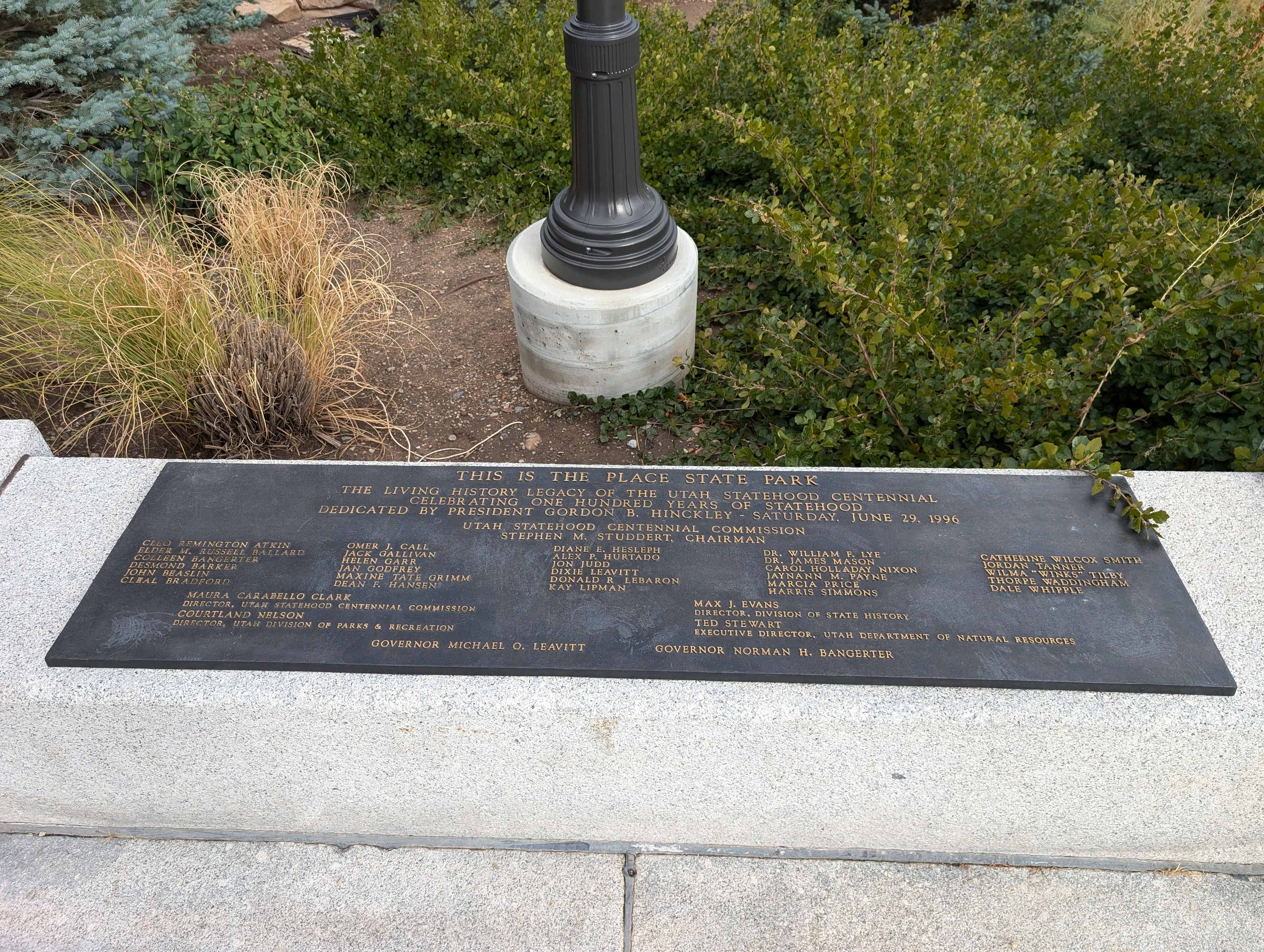
| UPTLA #100 | This is the Place State Park | Salt Lake City, Salt Lake, Utah | Distant Close up | N 40.75205 W 111.81632 |
| UPTLA #108 | Nauvoo Road | Alvinson, Ontario, Canada | N 42.82116 W 81.86998 | |
| UPTLA #109 | Union Fort | Midvale, Salt Lake, Utah | Distant Close up | N 40.62112 W 111.85891 |
| UPTLA #110 | Providence Pioneers | Providence, Cache, Utah | Distant Close up | N 41.70778 W 111.81751 |
| UPTLA #112 | Captain James Brown | Ogden, Weber, Utah | Distant Close up | N 41.22028 W 111.97125 |
| UPTLA #113 | Lorin Farr | Ogden, Weber, Utah | Distant Close up | N 41.22028 W 111.97125 |
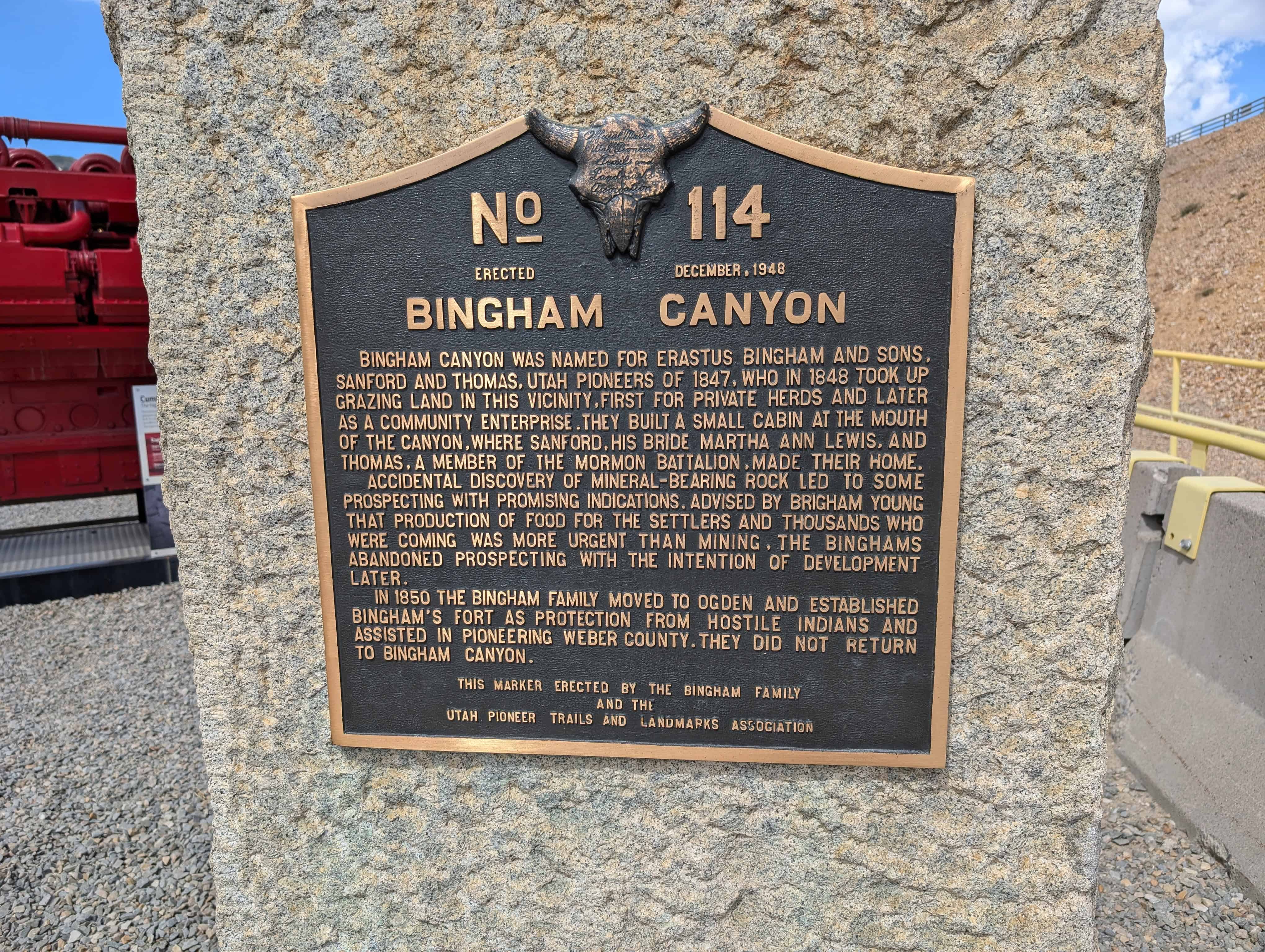
| UPTLA #114 | Bingham Canyon | Bingham Canyon, Salt Lake, Utah | Distant Close up | N 40.53791 W 112.14505 |
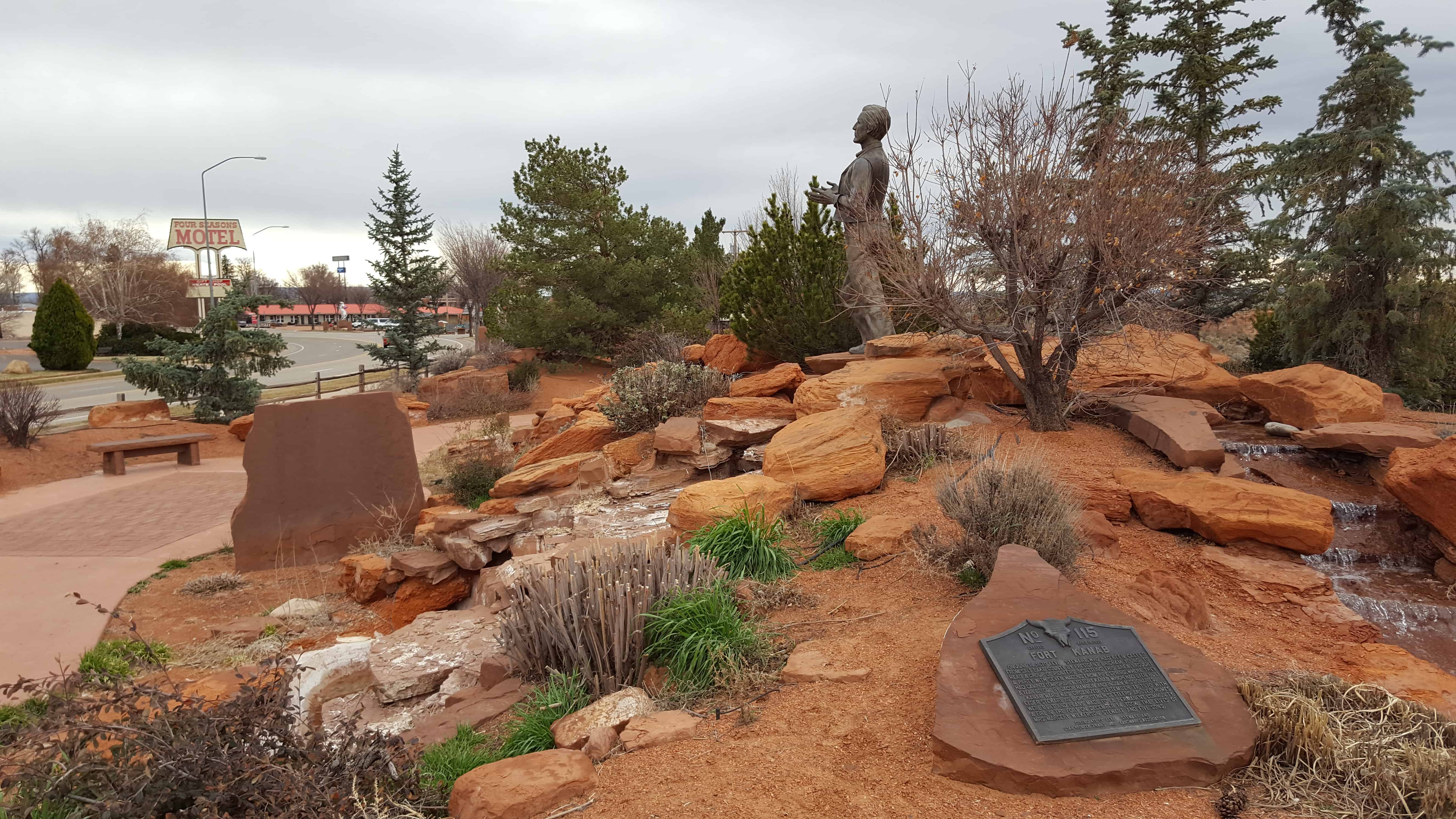
| UPTLA #115 | Fort Kanab | Kanab, Kane, Utah | Distant Close up | N 37.04951 W 112.53530 |
| UPTLA #116 | The Salmon River Mission - Fort Lemhi | Tendoy, Lemhi, Idaho | N 44.98346 W 113.63998 | |
| UPTLA #117 | Mormon Pioneer Trail | Fremont, Dodge, Nebraska | N 41.43524 W 96.49051 | |
| UPTLA #118 & SUP A | Pioneers of Lehi | Lehi, Utah, Utah | Distant Close up | N 40.37229 W 111.88449 |
| UPTLA #119 | Captain Jefferson Hunt | Downey, Bannock, Idaho | Distant Close up | N 42.35453 W 112.04905 |
| UPTLA #120 | Weld the Past to the Present to Enrich the Future | Ogden, Weber, Utah | Distant Close up | N 41.22077 W 111.97971 |
| UPTLA #130 | Mormon Pioneer Memorial Bridge | Florence, Douglas, Nebraska | N 41.33740 W 95.96088 | |
| UPTLA #131 | Mormon Pioneer Memorial Bridge | Crescent, Pottawattamie, Illinois | N 41.34590 W 95.95562 | |
| UPTLA #131 | The George Albert Smith Arch | Bluff, San Juan, Utah | N 38.10516 W 109.76808 | |
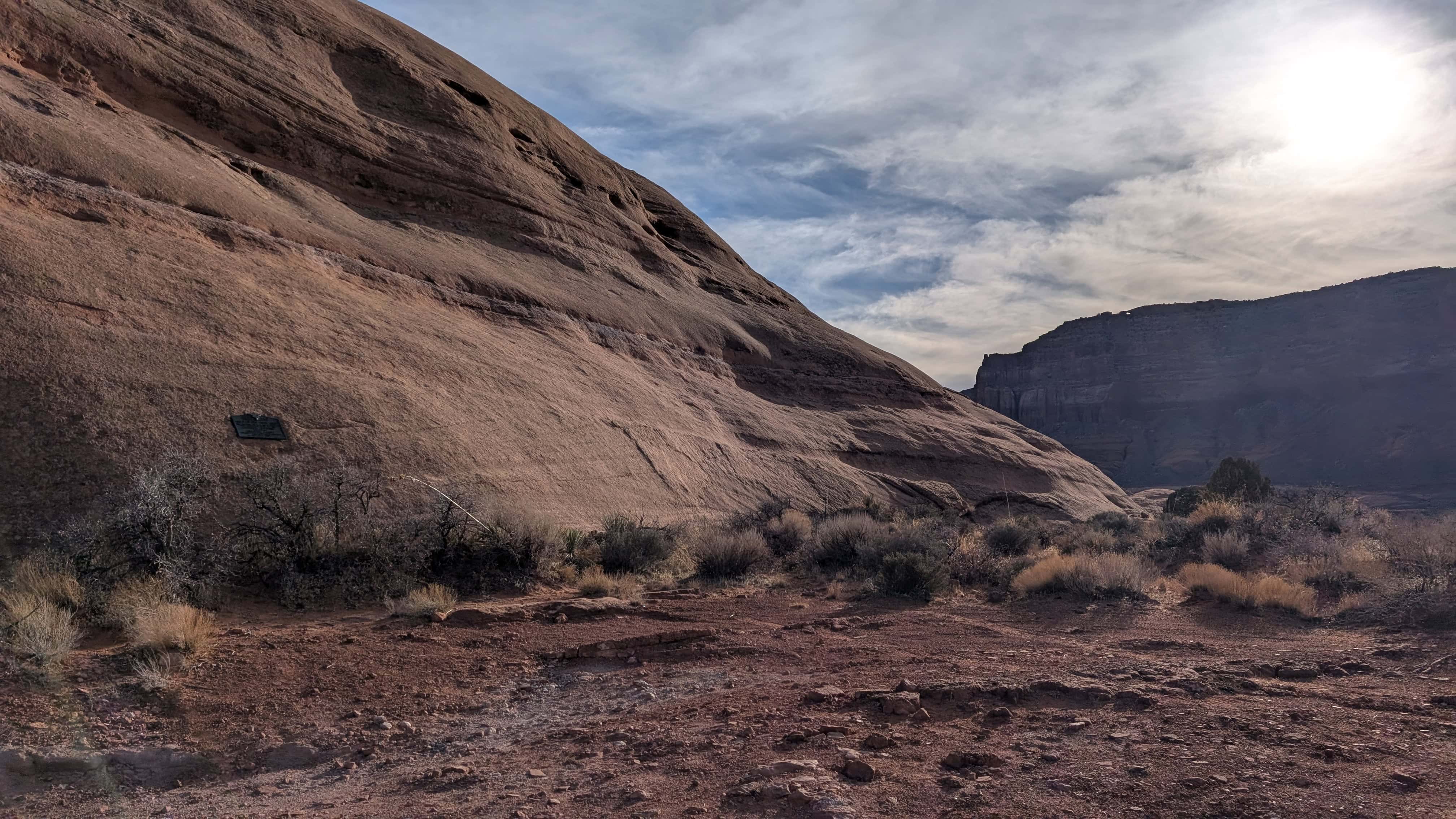
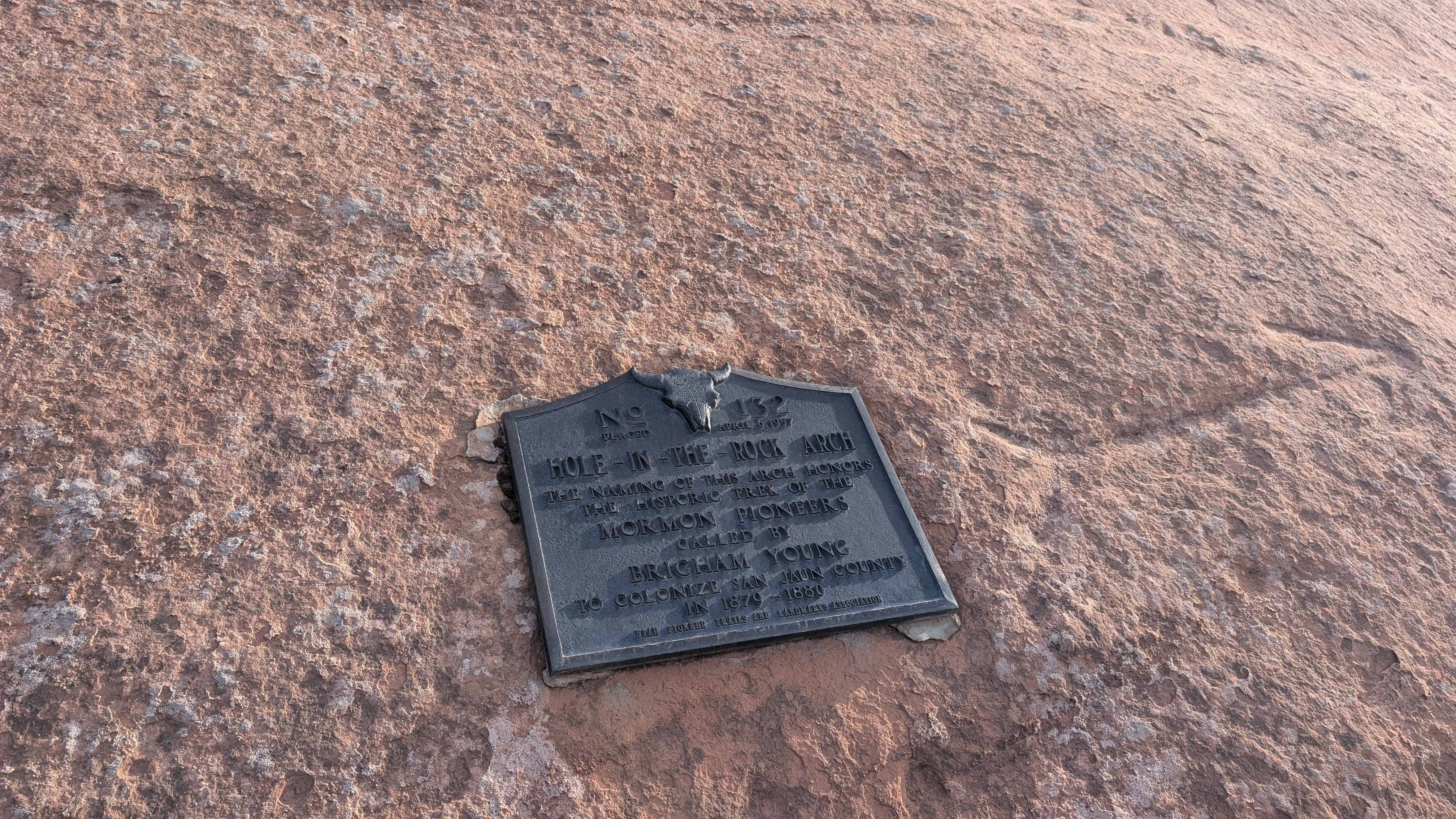
| UPTLA #132 | Hole-in-the-Rock Arch | Hole-in-the-Rock, Kane, Utah | Distant Close up | N 37.25755 W 110.95983 |
| UPTLA #133 | Old Pleasant Grove Fort | Pleasant Grove, Utah, Utah | Distant Close up | N 40.36017 W 111.73589 |
| A & UPTLA 118 | Pioneers of Lehi | Lehi, Utah, Utah | Distant Close up | N 40.37229 W 111.88449 |
| A-1 | Mormon Emigrant Trail | Squaw Valley, Placer, California | ||
| B | Golden Spike – Joining of the Rails | Promontory, Box Elder, Utah | ||
| B-1 | Old Fort Site | Holladay, Salt Lake, Utah | Distant Close up | N 40.66775 W 111.82849 |
| C | Hampton’s Bear River Crossing | Collinston, Box Elder, Utah | Distant Close up | N 41.78634 W 112.10618 |
| C-1 | Nauvoo Flag Pole | Nauvoo, Hancock, Illinois | ||
| D | Pioneer Telegraph Office | Salt Lake City, Salt Lake, Utah | Distant Close up | N 40.76758 W 111.89094 |
| D-1 | First Latter-day Saint Chapel in Phoenix | Phoenix, Maricopa, Arizona | Distant Close up | N 33.45013 W 112.06554 |
| E | Abraham Lincoln, Frontiersman | New Salem, Pike, Illinois | ||
| E-1 | Pioneer Industry in Parleys Canyon | Salt Lake City, Salt Lake, Utah | Distant Close up | N 40.70849 W 111.80177 |
| F | Daniel C. Jackling | Salt Lake City, Salt Lake, Uta | Utah State Capitol | |
| F-1 | Spencer W. Kimball Home | Safford, Graham, Arizona | ||
| G | Lycurgus, Spartan Lawgiver, 9th century BC | Sparta, Central Square, Greece | N 37.07321 E 22.42490 | |
| G-1 | Logan Temple Marker | Logan, Cache, Utah | (Missing?) | |
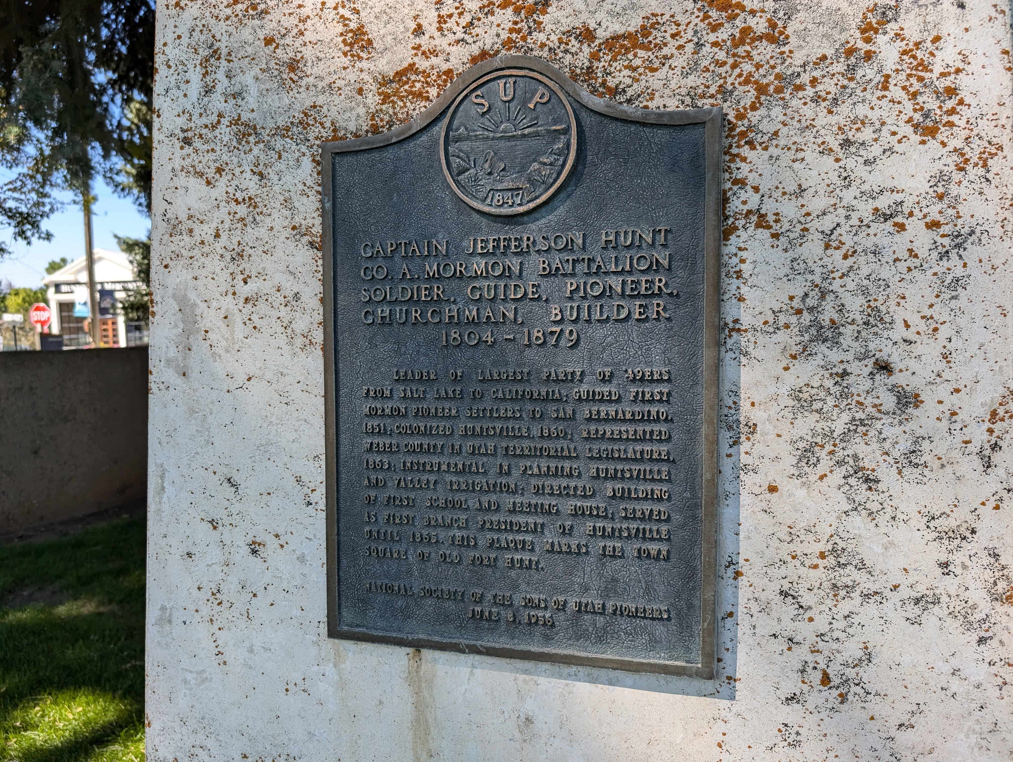
| H | Captain Jefferson Hunt | Huntsville, Weber, Utah | Distant Close up | N 41.26051 W 111.76980 |
| H-1 | Mormon Flat | Emigration Canyon, Morgan, Utah | N 40.82755 W 111.58335 (missing) |
|
| I | Brigham Young Bust | Salt Lake City, Salt Lake, Utah | Utah State Capitol | |
| I-1 | First Company of Pioneers into the Valley | Salt Lake City, Salt Lake, Utah | Distant Close up | N 40.75221 W 111.81606 |
| I-1 | Indian Trails Monument | North Ogden Canyon, Weber, Utah | Distant Close up | N 41.32048 W 111.89865 |
| J-1 | Union Pioneer Cemetery | Sandy, Salt Lake, Utah | Photo | N 40.60959 W 111.84880 |
| K & 138 & UPTLA 64 | Pioneer Flour Mill Site | Holladay, Salt Lake, Utah | Distant Close up | N 40.69662 W 111.81517 |
| K-1 | Orem Shortline Railroad | Orem, Utah, Utah | ||
| K-2 | Early Bennion History | Taylorsville, Salt Lake, Utah | ||
| K-3 | Route of Johnston’s Army | Taylorsville, Salt Lake, Utah | ||
| K-4 | Birch Springs | Emigration Canyon, Salt Lake, Utah | N 40.81077 W 111.67941 | |
| L | The San Juan Mission | Bluff, San Juan, Utah | Distant Close up | N 37.28708 W 109.54719 |
| M | Ira Merrill | Smithfield, Cache, Utah | Distant Close up | N 41.83687 W 111.83293 |
| N & P | 10 ton Granite Block Honoring the Builders of the Salt Lake Temple | Farmington, Davis, Utah | Lagoon | |
| O | Dance Hall Rock | Escalante, Kane, Utah | Distant Close up | N 37.35710 W 111.10080 |
| P & N | Pioneer Village: Original Vanguard Company | Farmington, Davis, Utah | Lagoon | |
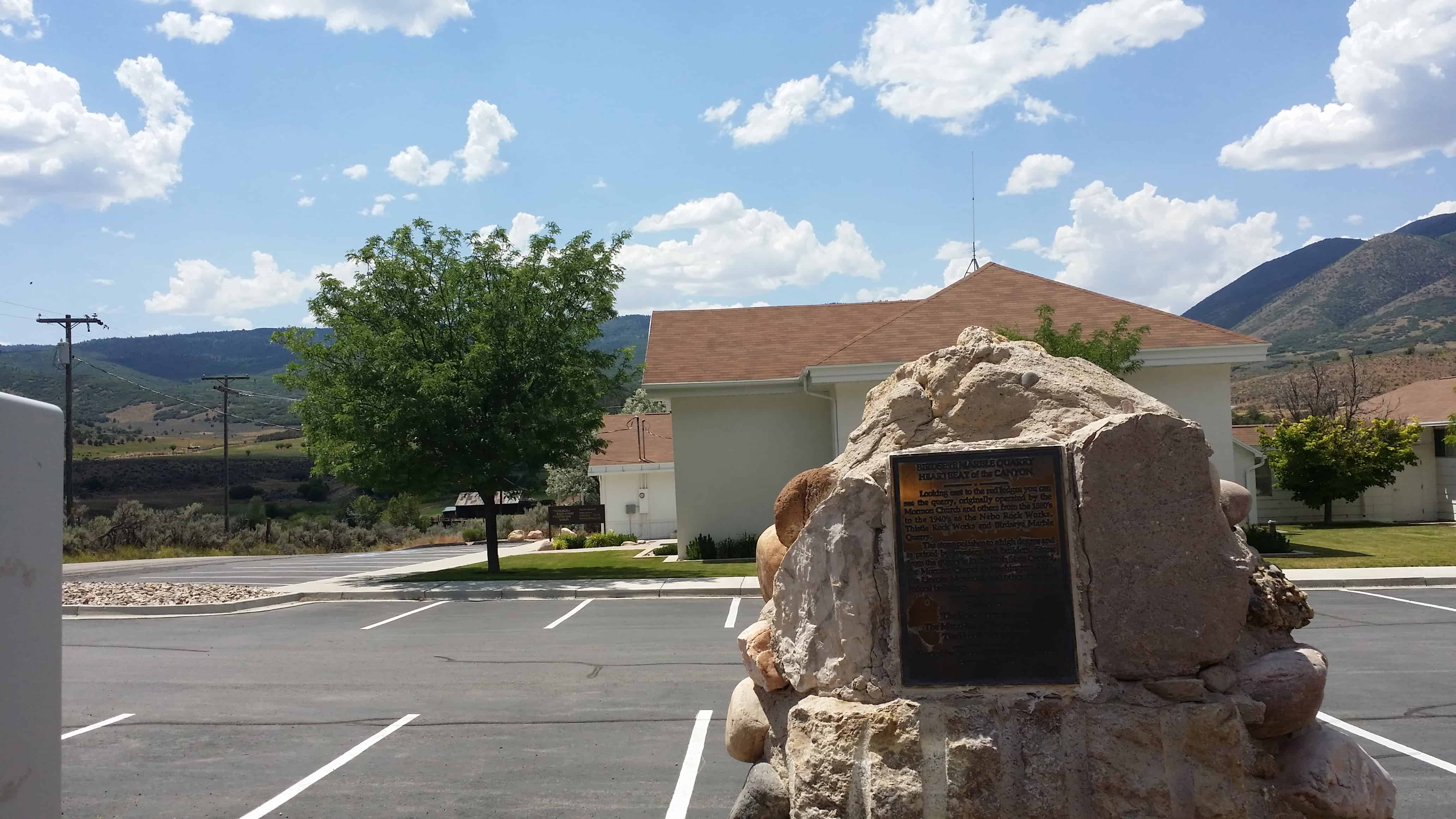
| P-1 | Birdseye Marble Quarry | Birdseye, Utah, Utah | Distant Close up | N 39.92451 W 111.54450 |
| Q | Col. Philip St. George Cooke | Fairfield, Utah, Utah | Distant Close up | N 40.26048 W 112.09308 |
| Q-1 | Pioneer Cemetery | Taylorsville, Salt Lake, Utah | 4575 S. Jordan River Parkway | |
| R | Huntsville Fountain | Huntsville, Weber, Utah | Distant Close up | N 41.26059 W 111.76926 |
| R-1 | Pioneer Cemetery | Spanish Fork, Utah, Utah | ||
| S | First Camp of the Pioneers | Sycamore Valley Ranch, San Bernardino, California | ||
| S-1 | Sugar House Monument | Sugar House, Salt Lake, Utah | Distant Close up | N 40.72531 W 111.86018 |
| T | Sagwitch Timbimboo, Shoshone Chief | Washakie, Box Elder, Utah | N 41.94571 W 112.23417 | |
| U & UPTLA 28 | Martin’s Cove | Martin’s Cove, Natrona, Wyoming | ||
| V | The 500 Volunteer Soldiers of the Mormon Battalion 1846 – 1848 | San Diego, San Diego, California | N 32.75736 W 117.19408 | |
| W & UPTLA 53 | Faust Station Pony Express | Faust, Tooele, Utah | Distant Close up | N 40.17419 W 112.42745 |
| X | John C. Freemont Memorial | Parowan, Iron, Utah | Distant Close up | N 37.84012 W 112.82776 |
| Y | Lehi Chapel | Lehi, Utah, Utah | 200 West 200 South | |
| Z | Brigham Young Grave Statue ("All is Well”) | Salt Lake City, Salt Lake, Utah | Photo | N 40.77011 W 111.88558 |
| -- NOT NUMBERED -- | -- NOT NUMBERED -- | |||
| Dixie Junior College | St. George, Washington, Utah | N 37.10664 W 113.58354 | ||
| First Religious & Educational Building Outside Salt Lake City | Millcreek, Salt Lake, Utah | Photo | N 40.67890 W 111.88438 | |
| Golden Spike | Ogden, Weber, Utah | Photo | N 41.22090 W 111.97954 | |