
Daughters of Utah Pioneers Historic Markers
The Daughters of Utah Pioneers (D.U.P.) was organized April 11, 1901, with the stated purpose “to perpetuate the names and achievements of the men, women and children who were the pioneers in founding this commonwealth [Utah]: by preserving old landmarks, marking historical places, collecting artifacts and histories, establishing a library of historical matter, and securing manuscripts, photographs, maps, and all such data as shall aid in perfecting a record of the Utah pioneers.”
To date, the D.U.P. has placed 600+ historical markers on physical locations representative of the history of the vast Westward movement of the Utah Pioneers. These markers commemorate places, events, or persons of particular historical significance to Utah (and, indeed, the entire American West).
These markers can be found in eleven countries (Canada, Denmark, England, Germany, Holland, Ireland, Norway, Scotland, Sweden, Switzerland, Wales) and thirteen States (Arizona, California, Hawaii, Idaho, Louisiana, Nebraska, Nevada, New Mexico, Oregon, Texas, Utah, Wyoming)–although the majority of them are located in Utah and Idaho.
For an interactive map of the marker/monument locations to easily see which ones you can visit in a certain area, visit www.DupMap.com
I’ve really enjoyed the markers I’ve come across over the course of my travels, and have set a goal to visit or re-visit them all and get information, location, and photo and create my own little database.
All Photos here are taken by me (Jacob Barlow.) The markers/monuments I have been to are linked to pages about them by clicking on the marker name.
| # | Marker Name | Address_____________ | City | County and State | Photos | GPS Coordinates______ |
|---|---|---|---|---|---|---|
| 1 | Tooele Pioneers | 44 West 520 South | Tooele | Tooele, Utah | Distant Close up | N 40.52090 W 112.30004 |
| 2 | Salt Creek Fort | 537 North 100 East | Nephi | Juab, Utah | Distant Close up | N 39.71635 W 111.83452 |
| 3 | Cedar Springs Fort | 102 North 100 East | Holden | Millard, Utah | Distant Close up | N 39.10101 W 112.26871 |
| 4 | Primary Association Organized | 272 North Main | Farmington | Davis, Utah | Distant Close up | N 40.98471 W 111.88737 |
| 5 | Spanish Fork Indian Farm | 1616 West 7300 South | Spanish Fork | Utah, Utah | Distant Close up | N 40.09834 W 111.69387 |
| 6 | Cove Fort | 17655 S Cove Fort Rd | Cove Fort | Millard, Utah | Distant Close up | N 38.60148 W 112.58034 |
| 7 | Utah's First Capitol | 50 West Capitol St | Fillmore | Millard, Utah | Distant Close up | N 38.96756 W 112.32508 |
| 8 | Fillmore Pioneer Fort | 5 South Main Street | Fillmore | Millard, Utah | Distant Close up | N 38.96874 W 112.32349 |
| 9 | Cache County Relic Hall | 110 West 100 South | Logan | Cache, Utah | Distant Close Up | N 41.72905 W 111.83824 |
| 10 | Bountiful Tabernacle | 55 South Main | Bountiful | Davis, Utah | Distant Close up | N 40.88886 W 111.87956 |
| 11 | Salt Creek Canyon Massacre | Nephi Canyon | Nephi | Juab, Utah | Distant Close up | N 39.70336 W 111.70651 |
| 12 | Last Camp Site | 6315 Emigration Canyon Rd | Salt Lake City | Salt Lake, Utah | Distant Close up | N 40.77878 W 111.72931 |
| 13 | Old Rock School House | 90 S Main St | Coalville | Summit, Utah | Distant Close up | N 40.91437 W 111.39753 |
| 14 | The Dixie Pioneers | 97 E St George Blvd | St. George | Washington, Utah | Distant Close up | N 37.11026 W 113.58139 |
| 15 | Richmond Fort | 47 S 200 W | Richmond | Cache, Utah | Distant Close up | N 41.92191 W 111.81424 |
| 16 | Father Escalante | 400 E Main St | Duchesne | Duchesne, Utah | Distant Close up | N 40.16314 W 110.39383 |
| 17 | The Lincoln Mine | 102 W Main St | Minersville | Beaver, Utah | Distant Close up | N 38.21560 W 112.92599 |
| 18 | Newton Reservoir | 98 W Main St | Newton | Cache, Utah | Distant Close up | N 41.86233 W 111.99107 |
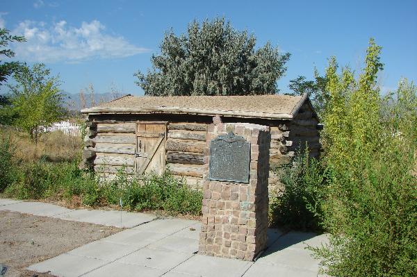
| 19 | Pioneer Cabin | 11 N State St | Morgan | Morgan, Utah | Distant Close up | N 41.03651 W 111.67776 |
| 20 | Hurricane Pioneers | 35 W State St | Hurricane | Washington, Utah | Distant Close up | N 37.17608 W 113.28869 |
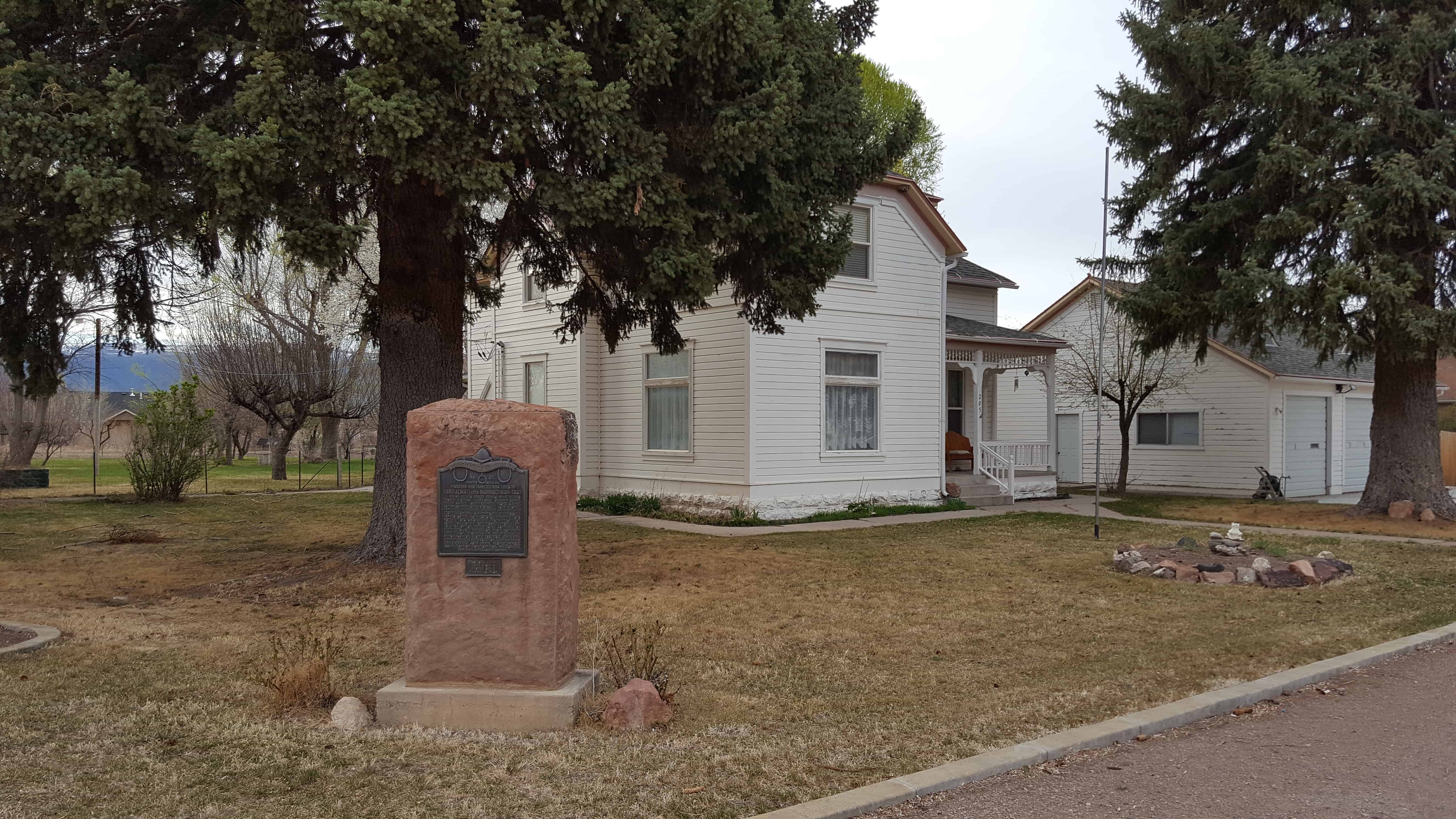
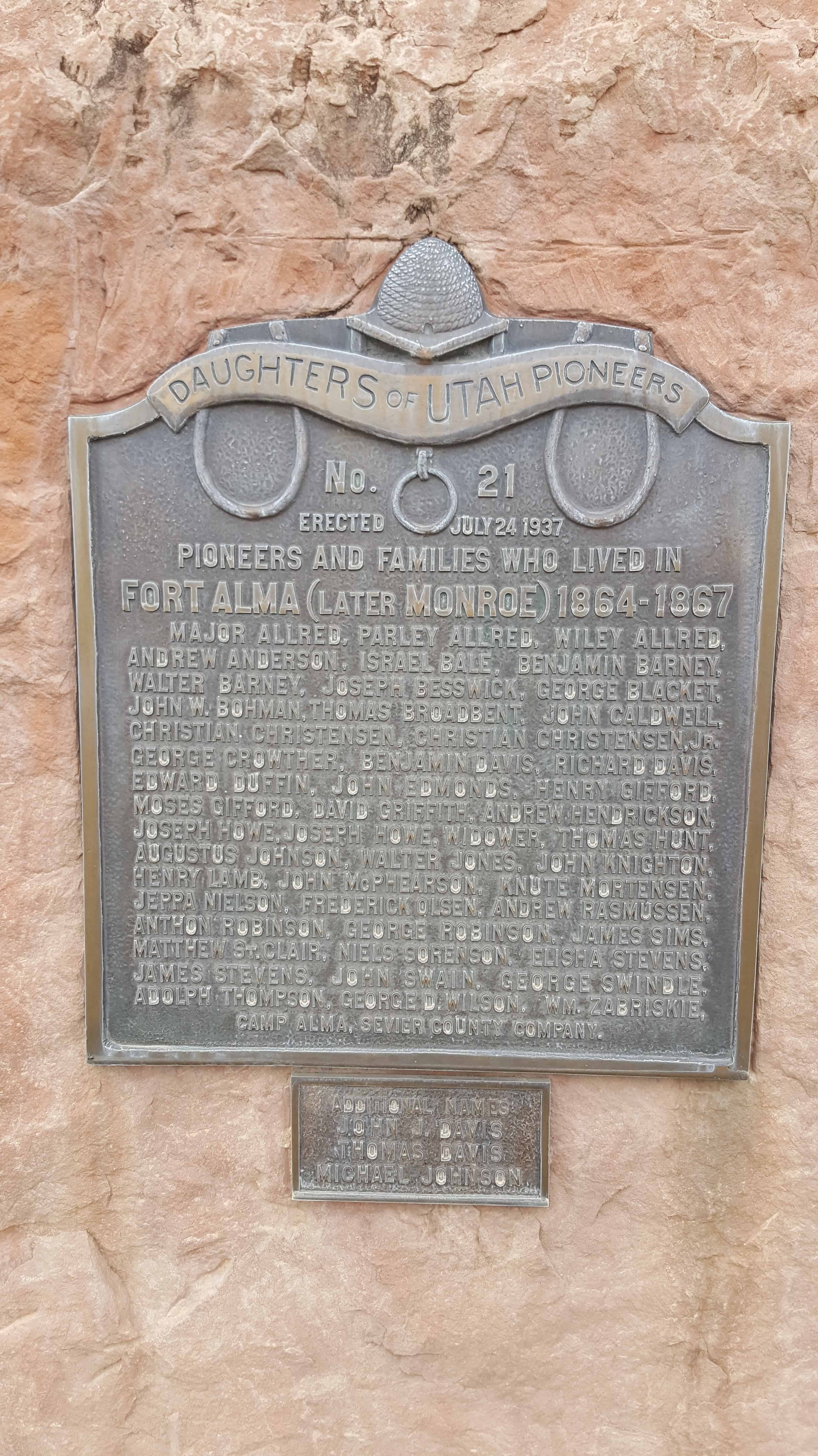
| 21 | Fort Alma | 205 N 100 W | Monroe | Sevier, Utah | Distant Close up | N 38.63557 W 112.12373 |
| 22 | Fort Utah | 120 N Geneva Rd | Provo | Utah, Utah | Distant Close up | N 40.23543 W 111.69449 |
| 23 | Fort Deseret | Highway 257 | Deseret | Millard, Utah | Distant Close up | N 39.26512 W 112.65328 |
| 24 | Rhoades Valley Fort | 91 W Center St | Kamas | Summit, Utah | Distant Close up | N 40.64293 W 111.28266 |
| 25 | Heber C. Kimball Grist Mill | 911 Orchard Dr | Bountiful | Davis, Utah | Distant Close up | N 40.88016 W 111.87300 |
| 26 | Jensen (Mau-be) Ferry | 10050 E 6000 S | Jensen | Uintah, Utah | Distant Close up | N 40.36995 W 109.33600 |
| 27 | First Stake Relief Society | 2104 Lincoln Ave | Ogden | Weber, Utah | Distant Close up | N 41.22883 W 111.97570 |
| 28 | Orderville Cemetery | 74 Red Hollow Dr | Orderville | Kane, Utah | Distant Close up | N 37.27235 W 112.63730 |
| 29 | Old Pioneer Cemetery | 350 N Main St | Mona | Juab, Utah | Distant Close up | N 39.82153 W 111.85488 |
| 30 | Pioneer Memories of 1866 | 50 N Main St | Logan | Cache, Utah | Distant Close up | N 41.73209 W 111.83324 |
| 31 | Beaver Woolen Mills | 402 E 400 N | Beaver | Beaver, Utah | Distant Close up | N 38.27955 W 112.63417 |
| 32 | The Manti Pioneers | 525 N 100 E | Manti | Sanpete, Utah | Distant Close up | N 39.27411 W 111.63484 |
| 33 | Pioneer Cabin | 635 N Main St | Cedar City | Iron, Utah | Distant Close up | N 37.68879 W 113.06275 |
| 34 | Eagle Rock Meeting House | Memorial Dr & Riverside Dr | Idaho Falls | Bonneville, Idaho | N 43.49728 W 112.04136 | |
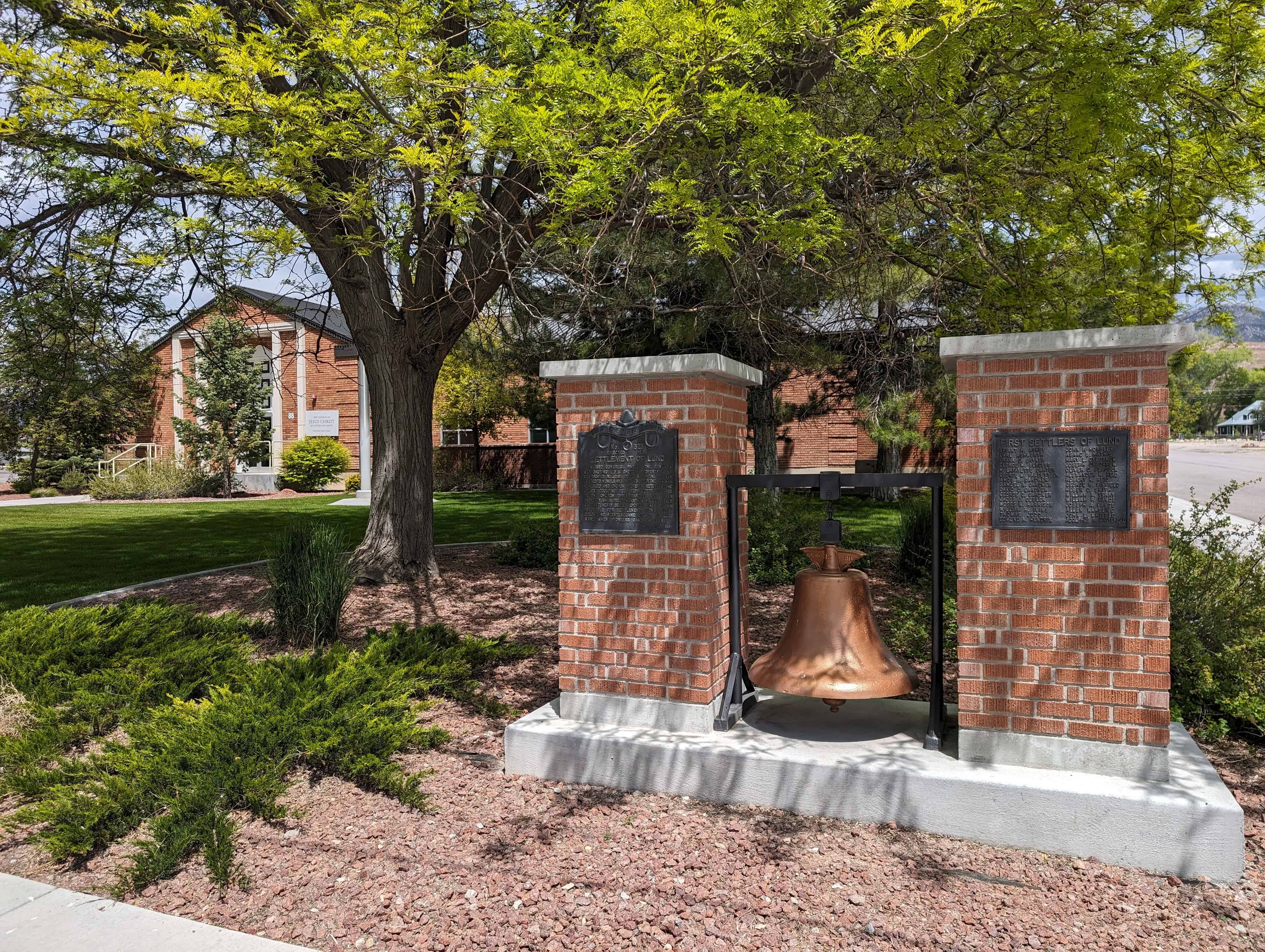
| 35 | First Icelandic Settlement in USA | 400 S 800 E | Spanish Fork | Utah, Utah | Distant Close up | N 40.104680 W 111.640965 |
| 36 | Pond Town Fort | 103 S 300 W | Salem | Utah, Utah | Distant Close up | N 40.05315 W 111.67918 |
| 37 | Old Fort and Hoyt Grist Mill | 1095 S Hoytsville Rd | Hoytsville | Summit, Utah | Distant Close up | N 40.874175 W 111.380287 |
| 38 | John Colter | 137 N Highway 33 | Driggs | Teton, Idaho | Distant Close up | N 43.74319 W 111.11033 |
| 39 | The Drown Log Cabin | 7650 Lind Ln | Midvale | Salt Lake, Utah | Distant Close up | N 40.61203 W 111.91422 |
| 40 | Las Vegas Fort | 500 E Washington Ave | Las Vegas | Clark, Nevada | Distant Close up | N 36.18058 W 115.13335 |
| 41 | Salina Fort and Tithing Office | Salina, Sevier, Utah | Distant Close up | N 38.95634 W 111.85822 | ||
| 42 | Discovery of Zion Canyon | Springdale, Washington, Utah | Distant Close up | N 37.18906 W 112.99819 | ||
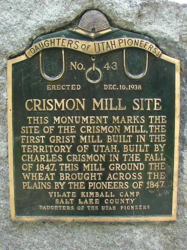
| 43 | Crismon Mill Site | Salt Lake City, Salt Lake, Utah | Distant Close up | N 40.77333 W 111.88634 | ||
| 44 | Relief Society Hall | Bicknell, Wayne, Utah | Distant Close up | N 38.34078 W 111.54584 | ||
| 45 | Richfield Pioneers | Richfield, Sevier, Utah | Distant Close up | N 38.77245 W 112.08379 | ||
| 46 | Fort Halleck | Elko, Elko, Nevada | N 40.80868 W 115.33614 | |||
| 47 | First Free Public School | American Fork, Utah, Utah | Distant Close up | N 40.37658 W 111.79664 | ||
| 48 | North Willow Creek Fort | 80 West 50 South | Willard | Box Elder, Utah | Distant Close up | N 41.40840 W 112.03850 |
| 49 | Swiss Colony | Santa Clara, Washington, Utah | Distant Close up | N 37.13298 W 113.65392 | ||
| 50 | Indian Peace Treaty | Heber City, Wasatch, Utah | Distant Close up | N 40.50783 W 111.41362 | ||
| 51 | Indian Trail | Oakley, Summit, Utah | Distant Close up | N 40.71481 W 111.29957 | ||
| 52 | First School House in Wyoming | Fort Bridger, Uinta, Wyoming | Distant Close up | N 41.31856 W 110.38997 | ||
| 53 | First University West of the Mississippi | Salt Lake City, Salt Lake, Utah | Distant Close up | N 40.77356 W 111.89414 | ||
| 54 | Old Tooele Ward Church | Tooele, Tooele, Utah | Distant Close up | N 40.53051 W 112.29899 | ||
| 55 | Settlement of Oxford | Oxford, Bannock, Idaho | Distant Close up | N 42.25869 W 112.02130 | ||
| 56 | Old Meeting House - Draper Fort | Draper, Salt Lake, Utah | Distant Close up | N 40.52266 W 111.86550 | ||
| 57 | The Mormon Battalion | San Diego, San Diego, California | Presidio Park | |||
| 58 | Pioneer Cemetery | Woods Cross, Davis, Utah | Distant Close up | N 40.87465 W 111.90043 | ||
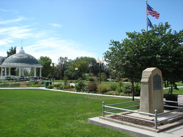
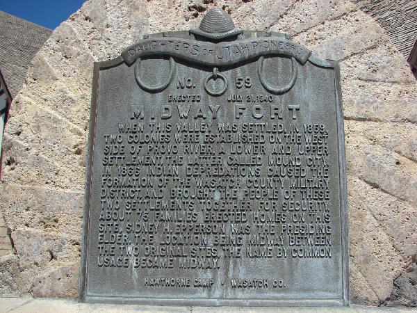
| 59 | Midway Fort | Midway, Wasatch, Utah | Distant Close up | N 40.51232 W 111.47468 | ||
| 60 | Ship Brooklyn Pioneers | San Francisco, Alameda, California | N 37.79878 W 122.40032 | |||
| 61 | Pioneer Mail Route | Franklin, Franklin, Idaho | N 42.14558 W 111.64219 | |||
| 62 | Panguitch Fort | Panguitch, Garfield, Utah | Distant Close up | N 37.82261 W 112.43152 | ||
| 63 | First Mills in Utah County | Springville, Utah, Utah | Distant Close up | N 40.18174 W 111.61030 | ||
| 64 | Beaver Stake Tabernacle | Beaver, Beaver, Utah | Distant Close up | N 38.27350 W 112.64193 | ||
| 65 | Elk Mountain Mission | Moab, Grand, Utah | Distant Close up | N 38° 34.433 W 109° 32.828 | ||
| 66 | Pioneer Church | Montpelier, Bear Lake, Idaho | N 42.31746 W 111.30013 | |||
| 67 | Military Training Campsite | New Harmony, Washington, Utah | Distant Close up | N 37° 28.948 W 113° 17.981 | ||
| 68 | Original Church Farm | Nibley, Cache, Utah | Distant Close up | N 41° 40.499 W 111° 50.865 | ||
| 69 | Weston Pioneers | Weston, Franklin, Idaho | N 42.03741 W 111.97961 | |||
| 70 | Pioneer Meeting House | 220 S Bridge St | St. Anthony | Fremont, Idaho | N 43.96453 W 111.68181 | |
| 71 | Charleston Pioneers | 3590 South 3600 West | Charleston | Wasatch, Utah | Distant Close up | N 40.46356 W 111.47155 |
| 72 | Fort Thornburgh | 1063 North 2500 | Vernal | Uintah, Utah | Distant Close up | N 40.47065 W 109.57694 |
| 73 | Pioneer Silk Industry | 1035 South 1800 East | Salt Lake City | Salt Lake, Utah | Distant Close up | N 40.74611 W 111.83889 |
| 74 | The Kelly Ranch | Springville, Utah, Utah | Distant Close up | N 40.16326 W 111.50345 | ||
| 75 | Starrh's Ferry | Highway 30 | Burley | Cassia, Idaho | N 42.53371 W 113.86869 | |
| 76 | Snowflake Settlement | Snowflake, Navajo, Arizona | ||||
| 77 | Glenwood United Order | Glenwood, Sevier, Utah | Distant Close up | N 38.77439 W 111.99147 | ||
| 78 | First Brick Church | Evanston, Uinta, Wyoming | Distant Close up | N 41.26530 W 110.96309 | ||
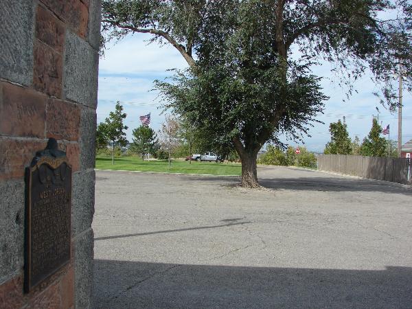
| 79 | West Jordan | West Jordan, Salt Lake, Utah | Distant Close up | N 40.60804 W 111.92512 | ||
| 80 | A Pioneer Home | 300 N Main St | Salt Lake City | Salt Lake, Utah | Distant Close up | N 40.77651 W 111.89114 |
| 81 | Toquerville | 10 Toquerville Blvd | Toquerville | Washington, Utah | Distant Close up | N 37.25473 W 113.28500 |
| 82 | English Fort | 4567 S Redwood Rd | Taylorsville | Salt Lake, Utah | Distant Close up | N 40.67074 W 111.93871 |
| 83 | Pioneer Cemetery | 1530 E 1900 S | Spanish Fork | Utah, Utah | Distant Close up | N 40.08548 W 111.62906 |
| 84 | Pioneer City Hall | 29 E Vine St | Tooele | Tooele, Utah | Distant Close up | N 40.53074 W 112.29749 |
| 85 | Iona | 3670 N Main St | Iona | Bonneville, Idaho | N 43.52928 W 111.92975 | |
| 86 | Rock Creek Station | 3170 E Pumpland Rd | Rock Creek | Twin Falls, Idaho | N 42.46035 W 114.32301 | |
| 87 | The Willow Creek Settlement | 13576 N 105 E | Idaho Falls | Bonneville, Idaho | N 43.61851 W 111.82432 | |
| 88 | Pioneer Cabin | 40 E Center St | Henefer | Summit, Utah | Distant Close up | N 41.01679 W 111.49901 |
| 89 | Pioneer Cabin | 2335 N 4350 W | Plain City | Weber, Utah | Distant Close up | N 41.30001 W 112.08541 |
| 90 | Pioneer Relic Hall | 73 S 100 E | Pleasant Grove | Utah, Utah | Distant Close up | N 40.36299 W 111.73867 |
| 91 | Milford Stamp Mill | Milford, Beaver, Utah | Distant Close up | N 38.39469 W 113.01251 | ||
| 92 | Brigham Young’s Garden Wall | Salt Lake City, Salt Lake, Utah | Distant Close up | N 40.77248 W 111.88368 | ||
| 93 | Old Fort of Franklin | Franklin, Franklin, Idaho | Distant Close up | N 42.01808 W 111.80444 | ||
| 94 | Escalante | Escalante, Garfield, Utah | Distant Close up | N 37.77022 W 111.60207 | ||
| 95 | First Pioneer Camp | Omaha, Douglas, Nebraska | N 41.36455 W 96.01911 | |||
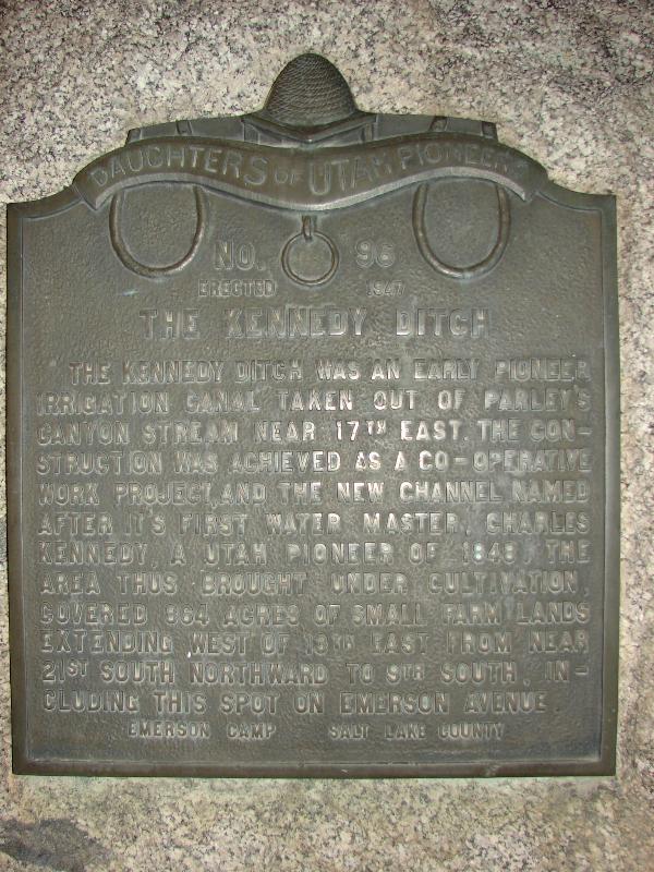
| 96 | The Kennedy Ditch | Salt Lake City, Salt Lake, Utah | Distant Close up | N 40.73368 W 111.85924 | ||
| 97 | St. George Tabernacle | St. George, Washington, Utah | Distant Close up | N 37.10772 W 113.58366 | ||
| 98 | Winter Home of Brigham Young | St. George, Washington, Utah | Distant Close up | N 37.11141 W 113.58501 | ||
| 99 | Bear River City | 4549 West 5900 North | Bear River City | Box Elder, Utah | Distant Close up | N 41.61631 W 112.12304 |
| 100 | The Old Rock Granary | 5605 S Vine St | Murray | Salt Lake, Utah | Distant Close up | N 40.64846 W 111.87044 |
| 101 | Lewiston Pioneers | 55 W Center St | Lewiston | Cache, Utah | Distant Close up | N 41.97567 W 111.85850 |
| 102 | Pioneer Camping Grounds | 110 E 400 S | Salt Lake City | Salt Lake, Utah | Distant Close up | N 40.76041 W 111.88777 |
| 103 | Adobe Rock | Highway 36 | Lake Point | Tooele, Utah | Distant Close up | N 40.66008 W 112.28843 |
| 104 | The Weinel Mill | 44 N Main St | Kaysville | Davis, Utah | Distant Close up | N 41.03565 W 111.93829 |
| 105 | Huntington | Highway 31 | Huntington | Emery, Utah | Distant Close up | N 39.35293 W 111.01271 |
| 106 | Rigby | 305 S Veteran Memorial Dr | Rigby | Jefferson, Idaho | N 43.66756 W 111.91573 | |
| 107 | Our Pioneers | 45 S 500 W | Payson | Utah, Utah | Distant Close up | N 40.04299 W 111.73952 |
| 108 | Sanford Pioneers | 755 Main St | Sanford | Conejos, Colorado | N 37.25798 W 105.90591 | |
| 109 | Santaquin | 47 E Main St | Santaquin | Utah, Utah | Distant Close up | N 39.97575 W 111.78441 |
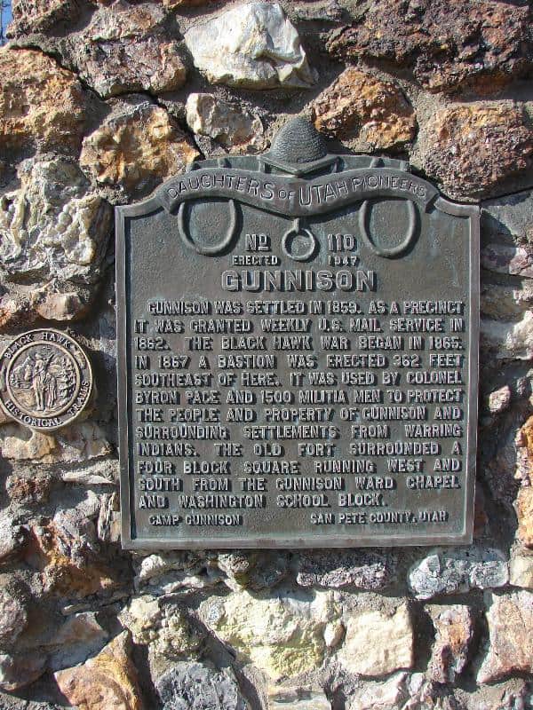
| 110 | Gunnison | 225 N Main St | Gunnison | Sanpete, Utah | Distant Close up | N 39.15891 W 111.81853 |
| 111 | First Public Building in Orangeville | Orangeville, Emery, Utah | Distant Close up | N 39.22765 W 111.05521 | ||
| 112 | Pioneer Cannon | Farmington, Davis, Utah | Distant Close up | N 40.98230 W 111.88735 | ||
| 113 | First Grist Mill in Weber County | Ogden, Weber, Utah | Distant Close up | N 41.24233 W 111.94798 | ||
| 114 | Pioneer Cemetery | American Fork, Utah, Utah | Distant Close up | N 40.38328 W 111.79619 | ||
| 115 | Garfield and Lake Point Resorts | Lake Point, Tooele, Utah | Distant Close up | N 40.74664 W 112.18543 | ||
| 116 | Pioneer Fire Station | 450 North Street | Ogden | Weber, Utah | Distant Close up | N 41.26681 W 111.96705 |
| 117 | Ferron Pioneers | Ferron, Emery, Utah | Distant Close up | N 39.09182 W 111.13303 | ||
| 118 | Pioneer Black Rock Resort | Lake Point, Tooele, Utah | Distant Close up | N 40.74664 W 112.18543 | ||
| 119 | Pioneer Cabin | Delta, Millard, Utah | Distant Close up | N 39.35251 W 112.57865 | ||
| 120 | Stage Coach Station | Centerville, Davis, Utah | Distant Close up | N 40.91706 W 111.87589 | ||
| 121 | Public Works | Parowan, Iron, Utah | Distant Close up | N 37.83898 W 112.8257 | ||
| 122 | Pioneer Rock Church | Parowan, Iron, Utah | Distant Close up | N 37.84109 W 112.82777 | ||
| 123 | Jackson Hole | Jackson, Teton, Wyoming | Distant Close up | N 43.47383 W 110.78792 | ||
| 124 | Cave | Magna, Salt Lake, Utah | Distant Close up | N 40.72183 W 112.15546 | ||
| 125 | Old Comedy Hall | Parowan, Iron, Utah | Distant Close up | N 37.84205 W 112.83185 | ||
| 126 | Pioneer Cemetery | Provo, Utah, Utah | Distant Close up | N 40.25791 W 111.67679 | ||
| 127 | Randolph | Randolph, Rich, Utah | Distant Close up | N 41.65596 W 111.18491 | ||
| 128 | Park City Pioneers | Park City, Summit, Utah | Distant Close up | N 40.66090 W 111.50714 | ||
| 129 | Moapa Valley Pioneers Replaced by #275 | Overton, Clark, Nevada | ||||
| 130 | Liberty Park | Salt Lake City, Salt Lake, Utah | Distant Close up | N 40.74963 W 111.87403 | ||
| 131 | First Playground | Salt Lake City, Salt Lake, Utah | Distant Close up | N 40.77848 W 111.86546 | ||
| 132 | Mormon Station | Genoa, Washo, Nevada | N 39.00407 W 119.84572 | |||
| 133 | First Coal Mine in Utah | Wales, Sanpete, Utah | Distant Close up | N 39.48728 W 111.63494 | ||
| 134 | La Verkin | La Verkin, Washington, Utah | Distant Close up | N 37.19938 W 113.26959 | ||
| 135 | First School House and Council House | Parowan, Iron, Utah | Distant Close up | N 37.84020 W 112.82739 | ||
| 136 | First Weather Station in Utah | 2335 N 4000 W | Corinne | Box Elder, Utah | Distant Close up | N 41.54866 W 112.11186 |
| 137 | Pioneers of Antimony | Antimony, Garfield, Utah | Distant Close up | N 38.11513 W 111.99669 | ||
| 138 | Settlement of Fruitland | Fruitland, San Juan, New Mexico | ||||
| 139 | The Little White Church | 504 11th Ave N | Nampa | Canyon, Idaho | Distant Close up | N 43.58422 W 116.55396 |
| 140 | Springville's First Camp Site | Springville, Utah, Utah | Distant Close up | N 40.16974 W 111.61407 | ||
| 141 | L.D.S. Tithing Office | Escalante, Garfield, Utah | Distant Close up | N 37.76994 W 111.60052 | ||
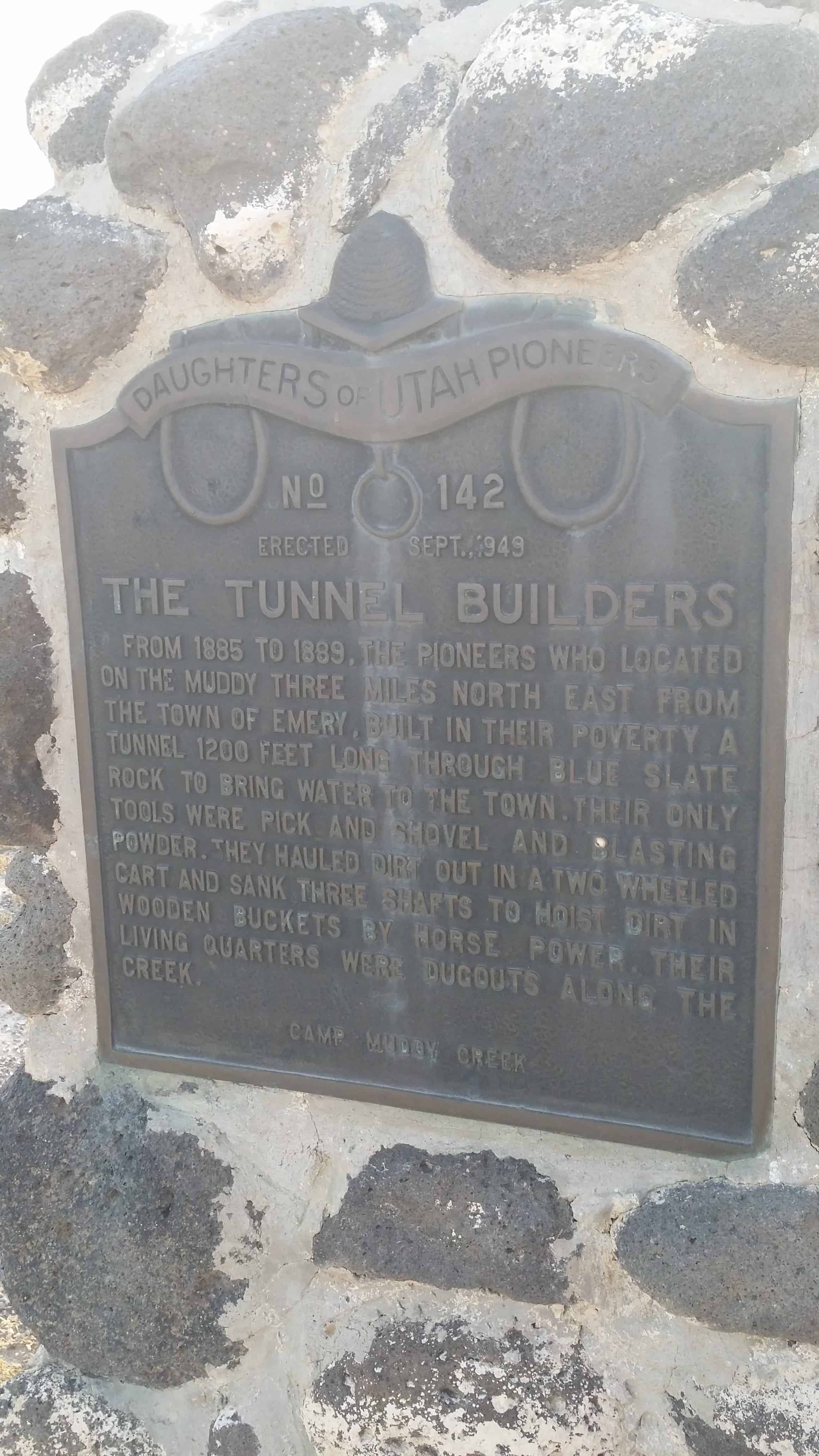
| 142 | The Tunnel Builders | Emery, Emery, Utah | Distant Close up | N 38.94883 W 111.21234 | ||
| 143 | The Providence Players | Providence, Cache, Utah | Distant Close up | N 41.70763 W 111.81767 | ||
| 144 | Indian Massacre | Ephraim, Sanpete, Utah | Distant Close up | N 39.35889 W 111.58726 | ||
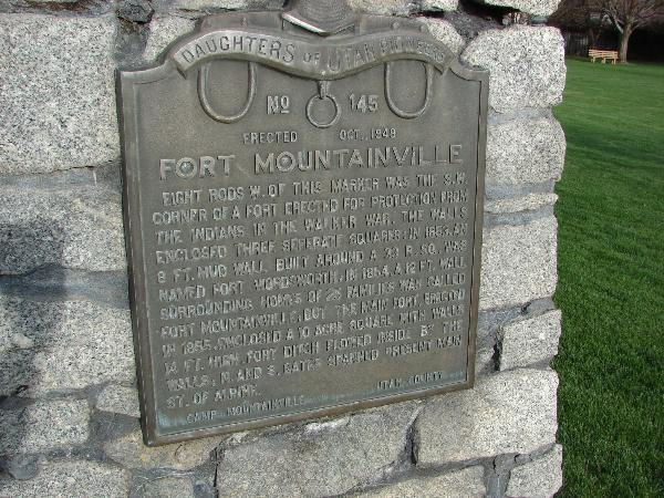
| 145 | Fort Mountainville | Alpine, Utah, Utah | Distant Close up | N 40.45281 W 111.77770 | ||
| 146 | Pioneer Memorial Cabin | Manti, Sanpete, Utah | Distant Close up | N 39.27007 W 111.63840 | ||
| 147 | Pioneer First Camp Ground | Beaver, Beaver, Utah | Distant Close up | N 38.26364 W 112.64450 | ||
| 148 | Relief Society Hall of Sanford | Sanford, Conejos, Colorado | ||||
| 149 | The Riter Cabin | Salt Lake City, Salt Lake, Utah | Distant Close up | N 40.75401 W 111.81784 | ||
| 150 | First LDS Missionaries in Hawaii | Honolulu, Oahu, Hawaii | ||||
| 151 | First Indian Agency | 3700 West 3750 North | Tabiona | Duchesne, Utah | Distant Close up | N 40.35343 W 110.70537 |
| 152 | First Settlers in Castle Dale | Castle Dale, Emery, Utah | Distant Close up | N 39.21185 W 111.01388 | ||
| 153 | Lehi Cemetery | Lehi, Utah, Utah | Distant Close up | N 40.39906 W 111.85055 | ||
| 154 | Syracuse First Social Center | Syracuse, Davis, Utah | Distant Close up | N 41.08830 W 112.06249 | ||
| 155 | Union Cemetery | Midvale, Salt Lake, Utah | Distant Close up | N 40.60959 W 111.84886 | ||
| 156 | LDS Pioneers of Boise | 1211 Cole Rd | Boise | Ada, Idaho | Distant Close up | N 43.59351 W 116.27763 |
| 157 | Payson's Pioneer Industry | Payson, Utah, Utah | Distant Close up | N 40.04044 W 111.73134 | ||
| 158 | Spring City Pioneers | Spring City, Sanpete, Utah | Distant Close up | N 39.47946 W 111.49633 | ||
| 159 | Battle of Cedar Ridge | Sigurd, Sevier, Utah | Distant Close up | N 38.84734 W 111.96659 | ||
| 160 | Elsinore | Elsinore, Sevier, Utah | Distant Close up | N 38.68613 W 112.14817 | ||
| 161 | Moroni Fort and Bastion | Moroni, Sanpete, Utah | Distant Close up | N 39.52366 W 111.58774 | ||
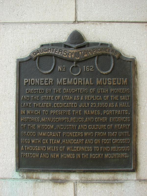
| 162 | Pioneer Memorial Museum | Salt Lake City, Salt Lake, Utah | Distant Close up | N 40.77655 W 111.89109 | ||
| 163 | The Bell of Neola | 2070 West 9000 North | Neola | Duchesne, Utah | Distant Close up | N 40.43288 W 110.03112 |
| 164 | Bingham's Fort | Ogden, Weber, Utah | Distant Close up | N 41.25927 W 111.98459 | ||
| 165 | Wanship Station | Wanship, Summit, Utah | Distant Close up | N 40.81755 W 111.40161 | ||
| 166 | Panguitch Stake Tabernacle | Panguitch, Garfield, Utah | Distant Close up | N 37.82292 W 112.43390 | ||
| 167 | Ammon | Ammon, Bonneville, Idaho | Distant Close up | N 43.47021 W 111.96746 | ||
| 168 | D.U.P. Relic Hall | Parowan, Iron, Utah | Distant Close up | N 37.84115 W 112.82869 | ||
| 169 | Mesa | Mesa, Maricopa, Arizona | Distant Close up | N 33.41580 W 111.81959 | ||
| 170 | First Las Vegas Post Office | Las Vegas, Clark, Nevada | Distant Close up | N 36.18063 W 115.13344 | ||
| 171 | Dayton, Idaho | Dayton, Franklin Idaho | N 42.11498 W 111.99356 | |||
| 172 | Uinta Springs | Fountain Green, Sanpete, Utah | Distant Close up | N 39.62816 W 111.64032 | ||
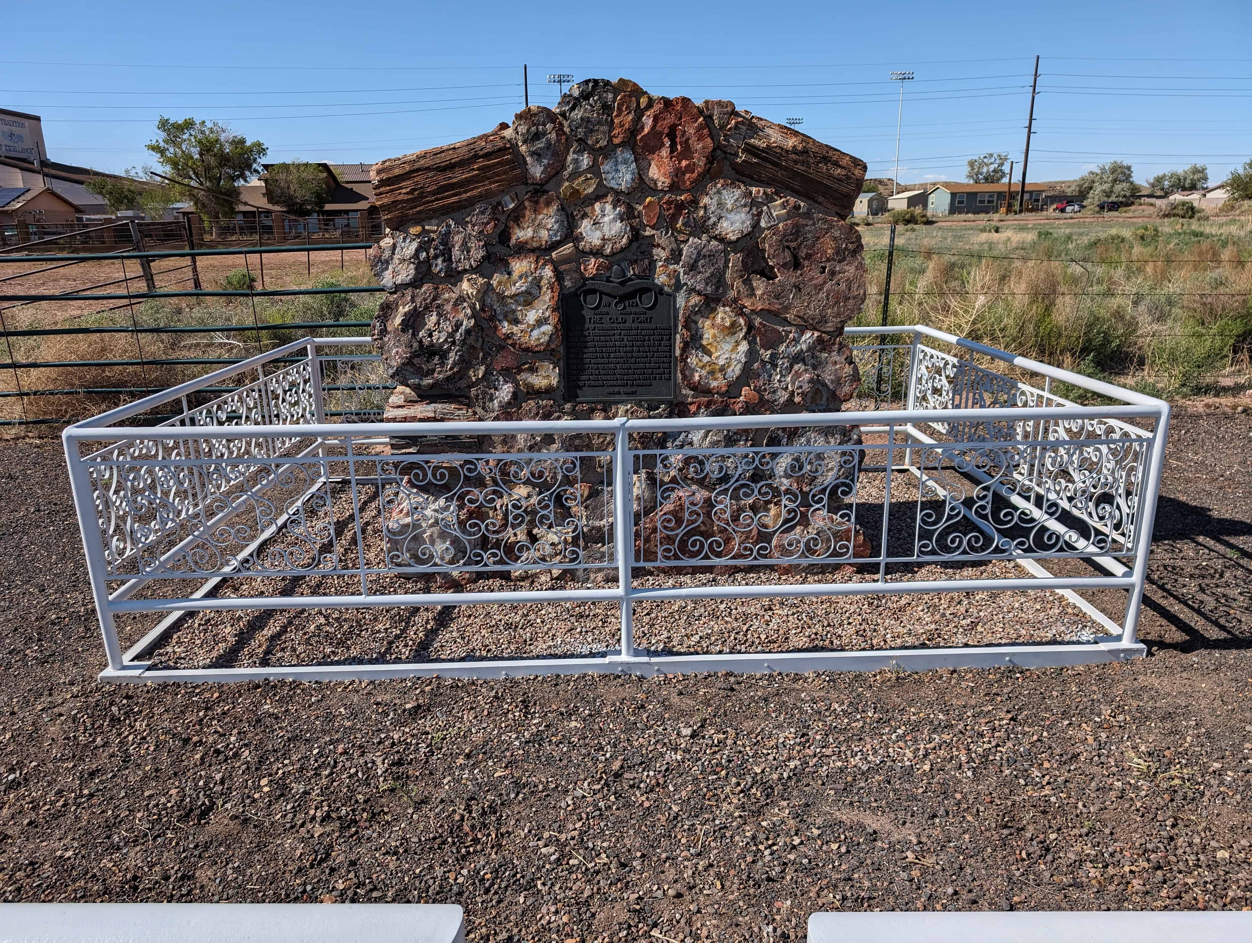
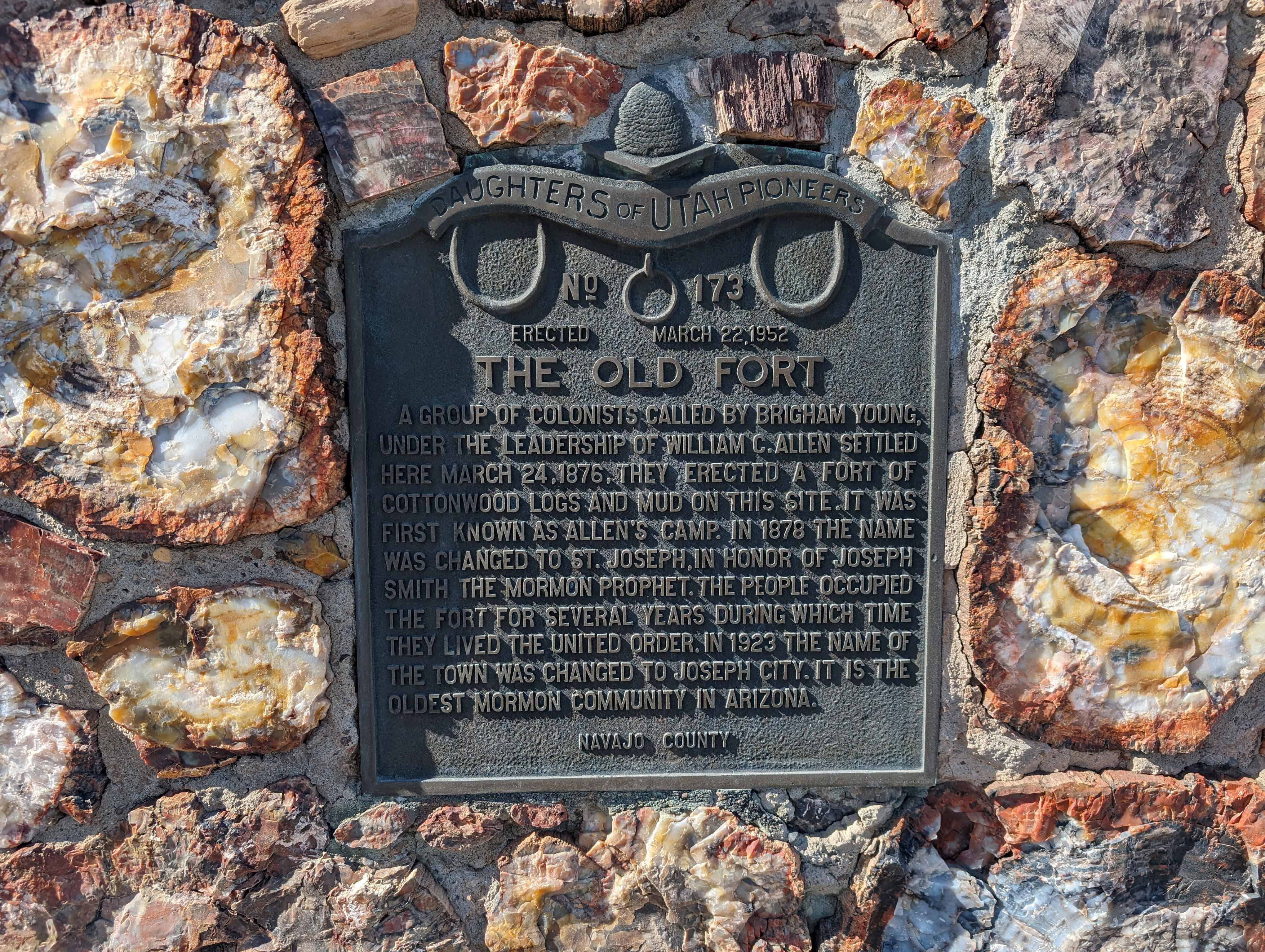
| 173 | The Old Fort | 4620 E Main St | Joseph City | Navajo, Arizona | Distant Close up | N 34.95606 W 110.32126 |
| 174 | Pioneer Mills of Cache Valley | Logan, Cache, Utah | Distant Close up | N 41.73217 W 111.83435 | ||
| 175 | Pottery Shop | Naples, Uintah, Utah | N 40.42164 W 109.49950 | |||
| 176 | Funk's Lake | Sterling, Sanpete, Utah | Distant Close up | N 39.19230 W 111.69274 | ||
| 177 | Farmington, New Mexico | Farmington, San Juan, New Mexico | N 36.73439 W 108.20929 | |||
| 178 | Old Ranger Station | Huntington, Emery, Utah | Distant Close up | N 39.32811 W 110.96783 | ||
| 179 | Cleveland | Cleveland, Emery, Utah | Distant Close up | N 39.34851 W 110.85696 | ||
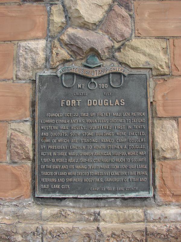
| 180 | Fort Douglas | Mario Capecchi Dr / Hempstead Rd | Salt Lake City | Salt Lake, Utah | Distant Close up | N 40.76268 W 111.83555 |
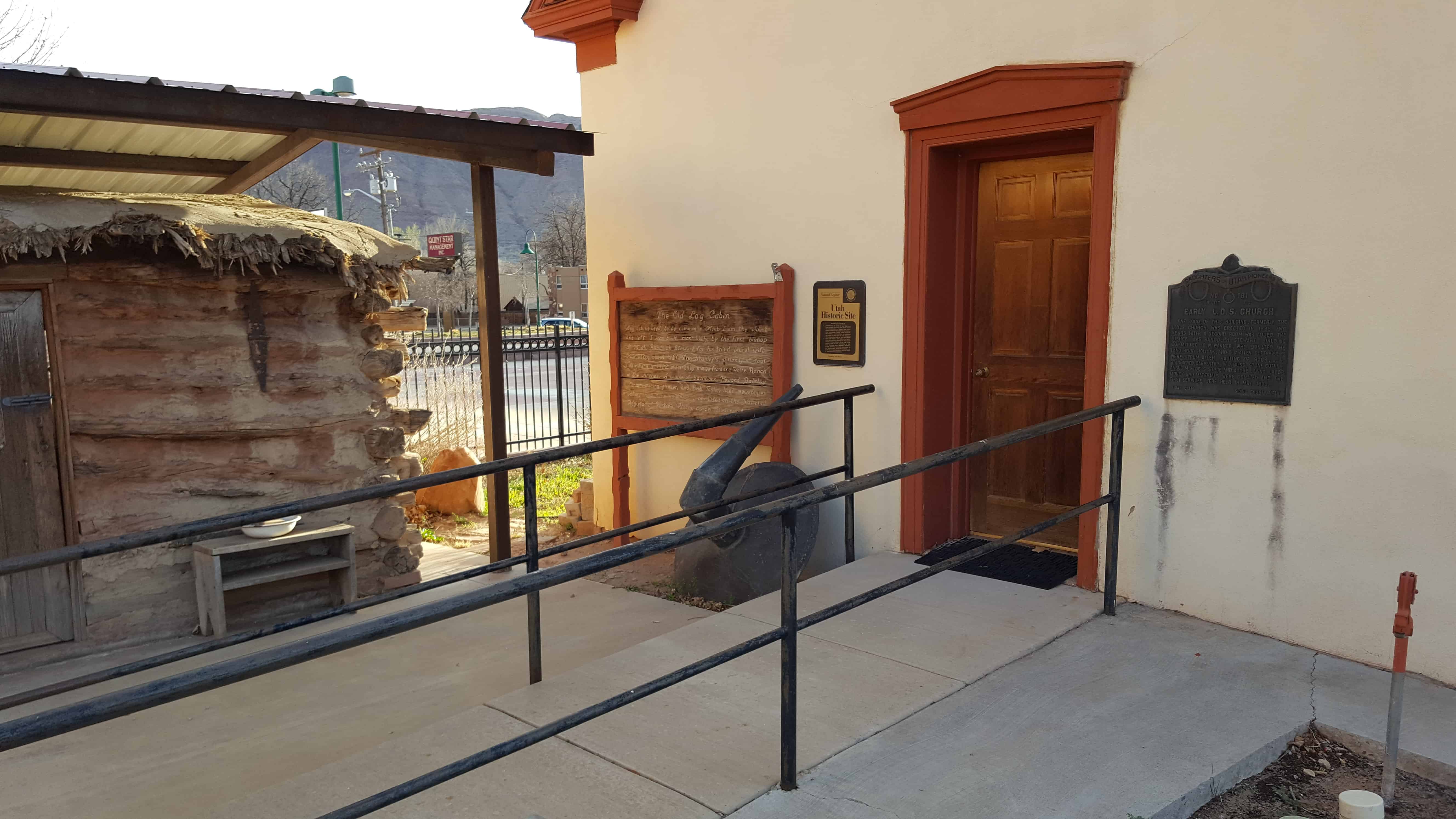
| 181 | Early LDS Church | 45 N 200 E | Moab | Grand, Utah | Distant Close up | N 38.57381 W 109.54709 |
| 182 | Coltman Ward | 12448 N 5th E | Ucon | Bonneville, Idaho | N 43.60713 W 112.02224 | |
| 183 | Snake River Bridge | 525 River Pkwy | Idaho Falls | Bonneville, Idaho | Distant Close up | N 43.49680 W 112.04386 |
| 184 | Academy Hall | 91 S 200 W | Richfield | Sevier, Utah | Distant Close up | N 38.76716 W 112.08817 |
| 185 | First Public Building | 106 S Main St | Teasdale | Wayne, Utah | Distant Close up | N 38.28353 W 111.47764 |
| 186 | Pioneer Women | Highway 91 / Hot Spring Road | Preston | Franklin, Idaho | Distant Close up | N 42.14076 W 111.91131 |
| 187 | Morgan Pioneer Memorial Building | 31 N State St | Morgan | Morgan, Utah | Distant Close up | N 41.03664 W 111.67784 |
| 188 | Central Ferry Station | 880 W Bridge St | Blackfoot | Bingham, Idaho | N 43.19273 W 112.35595 | |
| 189 | First Tithing Office | 172 S 500 W | Vernal | Uintah, Utah | Distant Close up | N 40.45319 W 109.53829 |
| 190 | Little Rock School House | 95 S 100 W | Fillmore | Millard, Utah | Distant Close up | N 38.96703 W 112.32631 |
| 191 | Settlement of Meadow | Meadow, Millard, Utah | Distant Close up | N 38.88585 W 112.40779 | ||
| 192 | Old Academy | Spanish Fork, Utah, Utah | Distant Close up | N 40.11408 W 111.65762 | ||
| 193 | Caineville | Caineville, Wayne, Utah | Distant Close up | N 38.32083 W 111.02765 | ||
| 194 | Public Buildings | St. Johns, Apache, Arizona | N 34.50696 W 109.36472 | |||
| 195 | Willow Creek Settlement | Ucon, Bonneville, Idaho | ||||
| 196 | Early Schools | Nephi, Juab, Utah | Distant Close up | N 39.71635 W 111.83452 | ||
| 197 | First Meeting House | Price, Carbon, Utah | Distant Close up | N 39.59968 W 110.80754 | ||
| 198 | First Public Buildings | Centerfield, Sanpete, Utah | Distant Close up | N 39.12178 W 111.81950 | ||
| 199 | Early Settlements | 790 N Russel St | Goshen | Bingham, Idaho | N 43.30973 W 112.08452 | |
| 200 | Kanosh | Kanosh, Millard, Utah | Distant Close up | N 38.80221 W 112.43758 | ||
| 201 | The Old Fort | Ephraim, Sanpete, Utah | Distant Close up | N 39.36148 W 111.58618 | ||
| 202 | Saw and Grist Mill | Provo, Utah, Utah | Distant Close up | N 40.25075 W 111.66140 | ||
| 203 | Calder's Park | Salt Lake City, Salt Lake, Utah | Distant Close up | N 40.70984 W 111.87159 | ||
| 204 | Pinto Settlement | Pinto, Washington, Utah | N 37.53920 W 113.51694 | |||
| 205 | Warm Creek | Fayette, Sanpete, Utah | ||||
| 206 | Glendale | 50 East 100 South | Glendale | Kane, Utah | Distant Close up | N 37.31594 W 112.59540 |
| 207 | Duchesne | Duchesne, Duchesne, Utah | Distant Close up | N 40.16355 W 110.4035 | ||
| 208 | Powell Survey | Kanab, Kane, Utah | Distant Close up | N 37.04962 W 112.53063 | ||
| 209 | Lime Kiln | Midway, Wasatch, Utah | Distant Close up | N 40.51585 W 111.46368 | ||
| 210 | Enterprise | 20 S Center St | Enterprise | Washington, Utah | Distant Close up | N 37.57337 W 113.72154 |
| 211 | St. Charles | 75 N Main St | St. Charles | Bear Lake, Idaho | N 42.11324 W 111.38912 | |
| 212 | Monticello | 165 S Main St | Monticello | San Juan, Utah | Distant Close up | N 37.87073 W 109.34278 |
| 213 | Washington Cotton Factory | 82 North Main Street | Washington | Washington, Utah | Distant Close up | N 37.13141 W 113.50967 |
| 214 | Francis | 52 West 2200 South | Francis | Summit, Utah | Distant Close up | N 40.61060 W 111.28177 |
| 215 | Pine Valley | 1150 E Highway 35 | Pine Valley | Washington, Utah | Distant Close up | N 37.38361 W 113.49304 |
| 216 | Shelley Settlement | 219 S Milton Ave | Shelley | Bingham, Idaho | N 43.37905 W 112.11818 | |
| 217 | Old Social Hall | 101 South 100 West | Orangeville | Emery, Utah | Distant Close up | N 39.22623 W 111.05463 |
| 218 | Escalante Trail | 190 West Main St | Delta | Millard, Utah | Distant Close up | N 39.35251 W 112.57855 |
| 219 | Last Chance Canal Co., Ltd. | 206 North Main St | Grace | Caribou, Idaho | N 42.57883 W 111.73024 | |
| 220 | Thomas L. Kane and the Mormons | 300 North Main St | Salt Lake City | Salt Lake, Utah | Distant Close up | N 40.77643 W 111.89125 |
| 221 | Lake Shore Fort | 1874 W 6400 S | Lake Shore | Utah, Utah | Distant Close up | N 40.11490 W 111.69924 |
| 222 | Fort Cedar | Behind 1342 W Industrial Rd | Cedar City | Iron, Utah | Distant Close up | N 37.68830 W 113.07972 |
| 223 | Rockland Valley | 160 S Cedar | Rockland | Power, Idaho | N 42.57353 W 112.87328 | |
| 224 | Ricks College | 525 S Center St | Rexburg | Madison, Idaho | N 43.82165 W 111.78313 | |
| 225 | Settlement of Fairview | 65 S State St | Fairview | Sanpete, Utah | Distant Close up | N 39.62721 W 111.43915 |
| 226 | Pioneer Cemetery | 2395 S Mill Rd | Heber City | Wasatch, Utah | Distant Close up | N 40.47830 W 111.39391 |
| 227 | Given Family Massacre | Highway 89 | Birdseye | Utah, Utah | Distant Close up | N 39.81504 W 111.50651 |
| 228 | Upper Snake River Valley Irrigation | Memorial Dr & Riverside Dr | Idaho Falls | Bonneville, Idaho | N 43.49707 W 112.04119 | |
| 229 | Corinne Opera House | 2335 N 4000 W | Corinne | Box Elder, Utah | Distant Close up | N 41.54891 W 112.11286 |
| 230 | Lewisville | 474 N 3450 E | Lewisville | Jefferson, Idaho | N 43.69561 W 112.01180 | |
| 231 | North Ogden | North Ogden, Weber, Utah | Distant Close up | N 41.30594 W 111.96021 | ||
| 232 | Bancroft's First School | 95 S Main St | Bancroft | Caribou, Idaho | N 42.71959 W 111.88534 | |
| 233 | Reynolds' Flour Mill | 2495 W 1500 N | Maeser | Uintah, Utah | Distant Close up | N 40.47715 W 109.57687 |
| 234 | Settlement of Scipio | Scipio, Millard, Utah | Distant Close up | N 39.24610 W 112.10446 | ||
| 235 | Old Fort | Spanish Fork, Utah, Utah | Distant Close up | N 40.10898 W 111.65437 | ||
| 236 | Pioneer Ferry and Bridge | Preston, Franklin, Idaho | Distant Close up | N 42.12029 W 111.91465 | ||
| 237 | Star Valley | Afton, Lincoln, Wyoming | Distant Close up | N 42.72660 W 110.92757 | ||
| 238 | Bear Lake Valley Pioneers | Liberty, Bear Lake, Idaho | N 42.31742 W 111.45324 | |||
| 239 | Settlement of Clearfield | Clearfield, Davis, Utah | Distant Close up | N 41.11368 W 112.02318 | ||
| 240 | Mormon Island | Mountain Village Dr | Folsom | Sacramento, California | N 38.69928 W 121.12758 | |
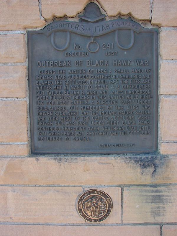
| 241 | Outbreak of Black Hawk War | 1650 South State St | Salina | Sevier, Utah | Distant Close up | N 38.93489 W 111.85487 |
| 242 | First Public Building | 89 South 300 West | Fremont | Wayne, Utah | Distant Close up | N 38.45637 W 111.62198 |
| 243 | Settlement of Greenville | 480 West Main St | Greenville | Beaver, Utah | Distant Close up | N 38.25486 W 112.72056 |
| 244 | Pioneer Cemetery | 850 North Highway 222 | Midway | Wasatch, Utah | Distant Close up | N 40.52650 W 111.48769 |
| 245 | Stage Coach Station | 900 West Pleasant View Dr | Pleasant View | Weber, Utah | Distant Close up | N 41.32123 W 112.00060 |
| 246 | Pioneer Schoolhouse & Chapel | 38134 Temple Way | Fremont | Alameda, California | Distant Close up | N 37.56300 W 121.98689 |
| 247 | Parcel Post Bank | 3 West Main St | Vernal | Uintah, Utah | Distant Close up | N 40.45556 W 109.52879 |
| 248 | Settlement of Blanding | 260 South Main St | Blanding | San Juan, Utah | Distant Close up | N 37.62173 W 109.47817 |
| 249 | First Tabernacle | 550 North 500 West | Provo | Utah, Utah | Distant Close up | N 40.24135 W 111.66701 |
| 250 | Showlow Valley Settlement | 300 N 11th St | Show Low | Navajo, Arizona | N 34.25293 W 110.03077 | |
| 251 | Stage Coach Station | Layton, Davis, Utah | Distant Close up | N 41.05833 W 111.96533 | ||
| 252 | The First L.D.S. Church | 1309 Fourth St | La Grande | Union, Oregon | Distant Close up | N 45.32394 W 118.09634 |
| 253 | The Old Fort | Heber City, Wasatch, Utah | Distant Close up | N 40.51517 W 111.41286 | ||
| 254 | Indian Peace Treaty | Koosharem, Sevier, Utah | Distant Close up | N 38.57306 W 111.84164 | ||
| 255 | The Grist Mill | Minersville, Beaver, Utah | Distant Close up | N 38.21454 W 112.91226 | ||
| 256 | First Public Building | Elmo, Emery, Utah | Distant Close up | N 39.38953 W 110.81650 | ||
| 257 | Women of the Mormon Battalion | San Diego, San Diego, California | Distant Close up | N 32.75726 W 117.19417 | ||
| 258 | Old Rock Schoolhouse | 110 E State St | Orderville | Kane, Utah | Distant Close up | N 37.27579 W 112.63593 |
| 259 | Pony Express Station | Murray, Salt Lake, Utah | Distant Close up | N 40.65651 W 111.87857 | ||
| 260 | Brigham Young's Summer Home | Soda Springs, Caribou, Idaho | N 42.65438 W 111.59989 | |||
| 261 | New Harmony | New Harmony, Washington, Utah | Distant Close up | N 37.47789 W 113.30860 | ||
| 262 | Lone Cedar Tree | Salt Lake City, Salt Lake, Utah | Distant Close up | N 40.76241 W 111.87394 | ||
| 263 | The Meeting House | Chesterfield, Caribou, Idaho | ||||
| 264 | City Hall | Payson, Utah, Utah | Distant Close up | N 40.04049 W 111.73134 | ||
| 265 | Pioneer Tabernacle | Ogden, Weber, Utah | Distant Close up | N 41.22887 W 111.97539 | ||
| 266 | First Public Building | Escalante, Garfield, Utah | Distant Close up | N 37.77178 W 111.60040 | ||
| 267 | Fort Wall at American Fork | American Fork, Utah, Utah | Distant Close up | N 40.37606 W 111.79608 | ||
| 268 | Frisco | Frisco, Beaver, Utah | Distant Close up | N 38.45238 W 113.25954 | ||
| 269 | Pioneer Cabin | Downey, Bannock, Idaho | Distant Close up | N 42.42881 W 112.12652 | ||
| 270 | Utah and the Civil War | Salt Lake City, Salt Lake, Utah | Distant Close up | N 40.77670 W 111.89044 | ||
| 271 | Allred Point | Fremont, Wayne, Utah | Distant Close up | N 38.43320 W 111.63176 | ||
| 272 | Settlement of East Carbon | Dragerton, Carbon, Utah | Distant Close up | N 39.52600 W 110.57224 | ||
| 273 | Settlement of South Weber | South Weber, Davis, Utah | Distant Close up | N 41.13356 W 111.94444 | ||
| 274 | Huntington's First Meeting House | Huntington, Emery, Utah | Distant Close up | N 39.32661 W 110.96475 | ||
| 275 | Moapa Valley Pioneers | 721 S Moapa Valley Blvd | Overton | Clark, Nevada | Distant Close up | N 36.53174 W 114.44081 |
| 276 | First Public Building -- Alpine | Alpine, Utah, Utah | Distant Close up | N 40.46095 W 111.77490 | ||
| 277 | First Post Office | Thayne, Lincoln, Wyoming | Distant Close up | N 42.92203 W 111.00252 | ||
| 278 | Pioneer Cedar Cemetery | Soda Springs, Caribou, Idaho | N 42.65908 W 111.58019 | |||
| 279 | Settlement of Lynne | Ogden, Weber, Utah | Distant Close up | N 41.26109 W 111.97384 | ||
| 280 | First School House | 668 N Rapid Creek Rd | Inkom | Bannock, Idaho | N 42.79871 W 112.24572 | |
| 281 | Pioneer Rock Wall | 105 S University St | Salt Lake City | Salt Lake, Utah | Distant Close up | N 40.76683 W 111.85219 |
| 282 | Pioneer Rock Church | 40 N Pioneer St | Herriman | Salt Lake, Utah | Distant Close up | N 40.51504 W 112.03294 |
| 283 | First Log House | 2424 N 1500 W | Vernal | Uintah, Utah | Distant Close up | N 40.49080 W 109.55786 |
| 284 | Salmon River Mission | Mule Shoe Rd & Lemhi Rd | Salmon | Lemhi, Idaho | N 44.98330 W 113.64044 | |
| 285 | First Irrigation Project | Mule Shoe Rd & Lemhi Rd | Salmon | Lemhi, Idaho | N 44.98335 W 113.64059 | |
| 286 | Highland Park | 530 W Elva St | Idaho Falls | Bonneville, Idaho | N 43.50411 W 112.03903 | |
| 287 | Stage Coach Station | 18526 S Olson Rd | Downey | Bannock, Idaho | N 42.49576 W 112.14956 | |
| 288 | Old City Hall, Now Known As Council Hall | 300 N State St | Salt Lake City | Salt Lake, Utah | Distant Close up | N 40.77578 W 111.88781 |
| 289 | Our First Church | 109 S Main St | Paris | Bear Lake, Idaho | N 42.22448 W 111.40076 | |
| 290 | United Order Industries | 15 W State St | Orderville | Kane, Utah | Distant Close up | N 37.27591 W 112.63908 |
| 291 | Utah & Northern Railroad | 880 S 5th Ave | Pocatello | Bannock, Idaho | N 42.86074 W 112.43636 | |
| 292 | Settlement of Hatch | Hatch, Garfield, Utah | Distant Close up | N 37.64964 W 112.43459 | ||
| 293 | First Relief Society Hall | Santaquin, Utah, Utah | Distant Close up | N 39.97575 W 111.78407 | ||
| 294 | Settlement of Fish Haven | Fish Haven, Bear Lake, Idaho | N 42.03916 W 111.39603 | |||
| 295 | Utah's First Fort | Salt Lake City, Salt Lake, Utah | Distant Close up | N 40.76118 W 111.89990 | ||
| 296 | Provo Woolen Mills | Provo, Utah, Utah | Distant Close up | N 40.23554 W 111.66073 | ||
| 297 | Pioneer Burial Grounds | Provo, Utah, Utah | Distant Close up | N 40.22456 W 111.64413 | ||
| 298 | The Stone Quarries | St. George, Washington, Utah | Distant Close up | N 37.11026 W 113.58139 | ||
| 299 | Pioneer Home | Salt Lake City, Salt Lake, Utah | Distant Close up | N 40.74568 W 111.87407 | ||
| 300 | First Post Office | 109800 East 7000 North | Lapoint | Uintah Utah | Distant Close up | N 40.40392 W 109.79401 |
| 301 | The First L.D.S. Church | 3140 North 3350 West | Moore | Butte, Idaho | Distant Close up | N 43.73381 W 113.36638 |
| 302 | Settlement of San Bernardino | 351 N Arrowhead Ave | San Bernardino | San Bernardino, California | Distant Close up | N 34.10506 W 117.28952 |
| 303 | Twentieth Ward School | 332 2nd Ave | Salt Lake City | Salt Lake, Utah | Distant Close up | N 40.7718 W 111.87895 |
| 304 | Early Schools | 5820 North 4800 West | Bear River City | Box Elder, Utah | Distant Close up | N 41.61472 W 112.12953 |
| 305 | Clay Hill Pass | Highway 276 | Blanding | San Juan, Utah | Distant Close up | N 37.41934 W 110.31379 |
| 306 | Fort Omni - Richfield | 91 South 200 West | Richfield | Sevier, Utah | Distant Close up | N 38.76684 W 112.08775 |
| 307 | Settlement of Kirtland | 473 County Road 6100 | Kirtland | San Juan, New Mexico | N 36.73386 W 108.35703 | |
| 308 | Old Rock Mill | 802 Rock Mill Ln | Farmington | Davis, Utah | Distant Close up | N 40.99319 W 111.88684 |
| 309 | Hamilton Fort | 3700 West 2700 South | Cedar City | Iron, Utah | Distant Close up | N 37.62838 W 113.13194 |
| 310 | Fort Buena Ventura | 731 West 24th St | Ogden | Weber, Utah | Distant Close up | N 41.22308 W 111.99612 |
| 311 | Old Tithing Office | Montpelier, Bear Lake, Idaho | N 42.32211 W 111.29880 | |||
| 312 | Old Rock Church | Salina, Sevier, Utah | Distant Close up | N 38.95677 W 111.85822 | ||
| 313 | Old Ashley Postoffice | 1333 West 2000 North | Vernal | Uintah, Utah | Distant Close up | N 40.48400 W 109.55462 |
| 314 | Warm Springs | Salt Lake City, Salt Lake, Utah | Distant Close up | N 40.78818 W 111.89960 | ||
| 315 | Fort Duchesne | 800 South 7500 East | Fort Duchesne | Uintah, Utah | Distant Close up | N 40.28836 W 109.85905 |
| 316 | Echo Gristmill | Henefer, Summit, Utah | Distant Close up | N 41.01651 W 111.49746 | ||
| 317 | LDS Birmingham Conference | Birmingham, Great Britain | ||||
| 318 | West Bountiful Church | West Bountiful, Davis, Utah | Distant Close up | N 40.89309 W 111.90217 | ||
| 319 | Relief Society Granary | Magna, Salt Lake, Utah | Distant Close up | N 40.68326 W 112.09141 | ||
| 320 | Marysvale | Marysvale, Piute, Utah | Distant Close up | N 38.44998 W 112.23033 | ||
| 322 | Bloomfield-Hammond | 470 Road 4990 | Bloomfield | San Juan, New Mexico | N 36.69353 W 107.91215 | |
| 322 | Logan's Hydro-Electric Plant | Logan, Cache, Utah | Distant Close up | N 41.72539 W 111.84395 | ||
| 323 | Settlement of Lund | 88 S Main St | Lund | White Pine, Nevada | Distant Close up | N 38.85683 W 115.00773 |
| 324 | Oregon Trail Campsite | Chesterfield, Caribou, Idaho | ||||
| 325 | Bloomfield-Hammond Settlement | Bloomfield, San Juan, New Mexico | ||||
| 326 | Cottonwood Paper Mill | Cottonwood Heights, Salt Lake, Utah | N 40.62688 W 111.79999 | |||
| 327 | Fort Cameron – Murdock Academy | Beaver, Beaver, Utah | Distant Close up | N 38.28030 W 112.60254 | ||
| 328 | Liberty | 3535 East 4100 North | Liberty | Weber, Utah | Distant Close up | N 41.33320 W 111.86319 |
| 329 | Oneida Station | Arimo, Bannock, Idaho | N 42.56098 W 112.17340 | |||
| 330 | Summit Stake Tabernacle | Coalville, Summit, Utah | Distant Close up | N 40.91421 W 111.39711 | ||
| 331 | Tooele's First Cemetery | Tooele, Tooele, Utah | Distant Close up | N 40.51648 W 112.30418 | ||
| 332 | West Jordan Pioneer Church | West Jordan, Salt Lake, Utah | Distant Close up | N 40.60804 W 111.92512 | ||
| 333 | Kimball-Whitney Cemetery | Salt Lake City, Salt Lake, Utah | Distant Close up | N 40.77294 W 111.89097 | ||
| 334 | Hansen Cooperative Dairy | Beaver Dam, Box Elder, Utah | Distant Close up | N 41.79461 W 112.03911 | ||
| 335 | Oakley Tabernacle | Oakley | Cassia, Idaho | N 42.24278 W 113.88439 | ||
| 336 | New Orleans-Port of Entry | New Orleans, Orleans, Louisiana | N 30.02703 W 90.21189 | |||
| 337 | Last Peace Treaty | Mt. Pleasant, Sanpete, Utah | Distant Close up | N 39.54463 W 111.45551 | ||
| 338 | Tragedy Spring | Sacramento, California | N 38.63939 W 120.14696 | |||
| 339 | The German Mission | Hamburg, Germany | ||||
| 340 | Fort Ashley Center | 92 W Main St | Vernal | Uintah, Utah | Distant Close up | N 40.45584 W 109.53014 |
| 341 | Pioneer Flour Mill | Pleasant Grove, Utah, Utah | Distant Close up | N 40.36297 W 111.73867 | ||
| 342 | Fort Sage Bottom | Peoa, Summit, Utah | Distant Close up | N 40.72598 W 111.34270 | ||
| 343 | Site of Mound Fort | Ogden, Weber, Utah | Distant Close up | N 41.24697 W 111.97345 | ||
| 344 | Arizona's Pioneer Women | Phoenix, Maricopa, Arizona | Distant Close up | N 33.44834 W 112.09504 | ||
| 345 | The Danish Mission | Copenhagen, Denmark | ||||
| 346 | Samaria | 4421 W 4900 S | Samaria | Oneida, Idaho | N 42.11555 W 112.33202 | |
| 347 | Pahreah | Pahria, Kane, Utah | Distant Close up | N 37.18606 W 111.99575 | ||
| 348 | Ivins Pioneer Cemetery | Ivins Road | Bancroft | Caribou, Idaho | N 42.72881 W 111.77891 | |
| 349 | Pioneer Cabin | Farmington, Davis, Utah | Distant Close up | N 40.98458 W 111.88628 | ||
| 350 | Lee's Ferry | Lees Ferry Road | Lee's Ferry | Coconino, Arizona | Distant Close up | N 36.86671 W 111.58536 |
| 351 | Tithing Granary | Elmo, Emery, Utah | Distant Close up | N 39.38866 W 110.81689 | ||
| 352 | New Plymouth | 150 W Ash St | New Plymouth | Payette, Idaho | Distant Close up | N 43.97272 W 116.82141 |
| 353 | The Swedish Mission | Malmo, Sweden | ||||
| 354 | Pioneer Cabin | Wellington, Carbon, Utah | Distant Close up | N 39.54228 W 110.73370 | ||
| 355 | Lake Fork | 1560 N Highway 87 | Upalco | Duchesne, Utah | Distant Close up | N 40.27887 W 110.21876 |
| 356 | Lest We Forget | Salt Lake City, Salt Lake, Utah | Distant Close up | N 40.77625 W 111.89042 | ||
| 357 | To Utah in 1868 | Laramie, Albany, Wyoming | ||||
| 358 | Transcontinental Railroad | Salt Lake City, Salt Lake, Utah | Distant Close up | N 40.76935 W 111.90275 | ||
| 359 | The Norwegian Mission | Drammen, Norway | ||||
| 360 | Startup Candy | Provo, Utah, Utah | Distant Close up | N 40.22644 W 111.66062 | ||
| 361 | Granger Settlement | 3580 S 3600 W | West Valley City | Salt Lake, Utah | Distant Close up | N 40.69368 W 111.97846 |
| 362 | The Scandinavian Branch | Gavle, Sweden | ||||
| 363 | The Welsh Mission | Merthyr Tydfil, Wales | ||||
| 364 | The Irish Mission | Belfast, Ireland | ||||
| 365 | Silver Fork | Big Cottonwood Canyon, Salt Lake, Utah | Distant Close up | N 40.63483 W 111.61487 | ||
| 366 | Circleville | Circleville, Piute, Utah | Distant Close up | N 38.17188 W 112.27031 | ||
| 367 | Scottish Mission | Paisley, Scotland | ||||
| 368 | Roosevelt | Cemetery, Highway 191 | Roosevelt | Duchesne, Utah | Distant Close up | N 40.28949 W 109.99842 |
| 369 | Utah Lake Resorts | 4090 W Center St | Provo | Utah, Utah | Distant Close up | N 40.23664 W 111.73167 |
| 370 | Granite Settlement | 9773 South 3100 East | Sandy | Salt Lake, Utah | Distant Close up | N 40.57363 W 111.80556 |
| 371 | Osmond | 3166 Highway 241 | Afton | Lincoln, Wyoming | Distant Close up | N 42.67782 W 110.93323 |
| 372 | Montgomery Ferry | 399 E Baseline Rd | Rupert | Minidoka, Idaho | N 42.61964 W 113.59075 | |
| 373 | Cedar Point – Basalt | 824 North 675 East | Basalt | Bingham, Idaho | N 43.31480 W 112.16508 | |
| 374 | Netherlands Mission | Amsterdam | Netherlands | |||
| 375 | Morgan Stake Tabernacle | 10 West Young St | Morgan | Morgan, Utah | Distant Close up | N 41.03576 W 111.67810 |
| 376 | Brigham Young Academy | 290 W Center St | Provo | Utah, Utah | Distant Close up | N 40.23393 W 111.66375 |
| 377 | First Millcreek Ward Chapel | 608 E 3515 S | Millcreek | Salt Lake, Utah | Distant Close up | N 40.68641 W 111.87369 |
| 378 | Pooles Island – Menan | 3547 E Menan Lorenzo Hwy | Menan | Jefferson, Idaho | N 43.72074 W 111.99401 | |
| 379 | Alta-Silver to Skis | 10500 Little Cottonwood Rd | Alta | Salt Lake, Utah | N 40.59153 W 111.63147 | |
| 380 | Bloomington | 102 W Canyon Street | Bloomington | Bear Lake, Idaho | N 42.18790 W 111.40440 | |
| 381 | Emmaville | 8787 S Wasatch Blvd | Cottonwood Heights | Salt Lake, Utah | Distant Close up | N 40.591350 W 111.794408 |
| 382 | Sloughhouse Pioneer Cemetery | Meiss Rd | Sloughhouse | Sacramento, California | N 38.49516 W 121.19112 | |
| 383 | South Jordan Settlement | 10630 S 1055 W | South Jordan | Salt Lake, Utah | Distant Close up | N 40.55830 W 111.92058 |
| 384 | Ephraim Settlement | 298 E 100 N | Ephraim | Sanpete, Utah | Distant Close up | N 39.36148 W 111.57954 |
| 385 | Overton | 159 W Virginia Ave | Overton | Clark, Nevada | Distant Close up | N 36.54040 W 114.44437 |
| 386 | Swiss Mission | Geneva, Switzerland | ||||
| 387 | The Walker War | 375 N 100 E | Levan | Juab, Utah | Distant Close up | N 39.56309 W 111.86243 |
| 388 | Myton | 78 East Main St | Myton | Duchesne, Utah | Distant Close up | N 40.194414 W 110.061850 |
| 389 | Saramarie Van Dyke Carriage House | 300 N Main St | Salt Lake City | Salt Lake, Utah | Distant Close up | N 40.77655 W 111.89109 |
| 390 | Spring Lake Villa | 12501 S State St | Spring Lake | Utah, Utah | Distant Close up | N 40.00107 W 111.75024 |
| 391 | Clinton | 1906 W 1800 N | Clinton | Davis, Utah | Distant Close up | N 41.14071 W 112.06269 |
| 392 | The Constitution Revered | 310 Columbus St | Salt Lake City | Salt Lake, Utah | Distant Close up | N 40.77660 W 111.89043 |
| 393 | Fremont Park | 285 W Main St | Fremont | Wayne, Utah | Distant Close up | N 38.45743 W 111.62140 |
| 394 | Fountain Green | 10 S State St | Fountain Green | Sanpete, Utah | Distant Close up | N 39.62813 W 111.63481 |
| 395 | Pioneer Log Cabin | 27 E Vine St | Tooele | Tooele, Utah | Distant Close up | N 40.53083 W 112.29760 |
| 396 | First Wayne Stake Tithing Office | 19 S 100 W | Loa | Wayne, Utah | Distant Close up | N 38.40181 W 111.64480 |
| 397 | Muskrat Springs-Hooper | 5525 W 5300 S | Hooper | Davis, Utah | Distant Close up | N 41.16690 W 112.11414 |
| 398 | Alpine | 550 N Main St | Alpine | Utah, Utah | Distant Close up | N 40.45391 W 111.77744 |
| 399 | Moonlake | 20800 W 3800 N | Altamont | Duchesne, Utah | Distant Close up | N 40.35543 W 110.38150 |
| 400 | Boise Ford | 10260 N 5200 W | Elwood | Box Elder, Utah | Distant Close up | N 41.69421 W 112.14146 |
| 401 | Sandy-Alta Railroad | Sandy, Salt Lake, Utah | Distant Close up | N 40.59293 W 111.87807 | ||
| 402 | Chaffin Grist Mill | Cedar City, Iron, Utah | Distant Close up | N 37.67440 W 113.05101 | ||
| 403 | Sterling | Sterling, Sanpete, Utah | Distant Close up | N 39.19332 W 111.69272 | ||
| 404 | Hogan Pioneer Cabin | Woods Cross, Davis, Utah | Distant Close up | N 40.87465 W 111.90051 | ||
| 405 | Spring Town | Spring City, Sanpete, Utah | Distant Close up | N 39.47638 W 111.49641 | ||
| 406 | Lava Hot Springs | Lava, Bannock, Idaho | N 42.61936 W 112.00684 | |||
| 407 | Levan | Levan, Juab, Utah | Distant Close up | N 39.55823 W 111.86219 | ||
| 408 | Fillmore's Adobe Church | Fillmore, Millard, Utah | Distant Close up | N 38.97947 W 112.32199 | ||
| 409 | Warm Creek – Fayette | Fayette, Sanpete, Utah | Distant Close up | N 39.22378 W 111.85461 | ||
| 410 | Georgetown's First Public Building | 161 W 3rd St | Georgetown | Bear Lake, Idaho | N 42.47406 W 111.37060 | |
| 411 | Riverton Tithing Yard Hill | 1452 West 12600 South | Riverton | Salt Lake, Utah | Distant Close up | N 40.51988 W 111.93347 |
| 412 | Golden Spike Monument | 6200 North 22300 West | Promontory | Box Elder, Utah | N 41.61733 W 112.55082 | |
| 413 | Welby | 4255 West 9000 South | West Jordan | Salt Lake, Utah | Distant Close up | N 40.58761 W 111.99279 |
| 414 | The First Sawmill | 55 South 300 West | Fremont | Wayne, Utah | Distant Close up | N 38.45696 W 111.62192 |
| 415 | Wilmington Wagon Train Seaport | 100 E Water St | Wilmington | Los Angeles, California | N 33.76671 W 118.26079 | |
| 416 | Ogden City Wall | 2501 Wall Ave | Ogden | Weber, Utah | Distant Close up | N 41.22090 W 111.97954 |
| 417 | Unknown Pioneers of Logan | 1000 North 1200 East | Logan | Cache, Utah | Distant Close up | N 41.74878 W 111.80862 |
| 418 | First Cedar Encampment | 1320 N Main St | Cedar City | Iron, Utah | Distant Close up | N 37.70035 W 113.06368 |
| 419 | “Annie’s Place” Annis | 3812 E Menan Lorenzo Hwy | Rigby | Jefferson, Idaho | N 43.72467 W 111.94004 | |
| 420 | Hunter | 3665 South 6000 West | West Valley City | Salt Lake, Utah | Distant Close up | N 40.69286 W 112.03412 |
| 421 | The 18th Ward Chapel | 150 E 300 N | Salt Lake City | Salt Lake, Utah | Distant Close up | N 40.77570 W 111.88674 |
| 422 | Dover Cemetery | W Fayette River Lane | Fayette | Sanpete, Utah | Distant Close up | N 39.20717 W 111.89617 |
| 423 | Fort Ephraim Peace Treaty | 75 W 100 N | Ephraim | Sanpete, Utah | Distant Close up | N 39.36110 W 111.58809 |
| 424 | Malan Heights | 1314 E 27th St | Ogden | Weber, Utah | Distant Close up | N 41.21630 W 111.94418 |
| 425 | Burton | 3958 W 2000 S | Rexburg | Madison, Idaho | N 43.79739 W 111.85701 | |
| 426 | Early Granger Schools | 3540 4000 W | West Valley City | Salt Lake, Utah | Distant Close up | N 40.69644 W 111.98762 |
| 427 | Bybee – Centerville | 401 West 1st St | Rigby | Jefferson, Idaho | N 43.66991 W 111.92462 | |
| 428 | Centerfield | 250 S Main St | Centerfield | Sanpete, Utah | Distant Close up | N 39.12178 W 111.81950 |
| 429 | Site of Two Alpine Churches | 15 S Main St | Alpine | Utah, Utah | Distant Close up | N 40.45312 W 111.77770 |
| 430 | Covington Mansion | 181 E 200 N | Washington | Washington, Utah | Distant Close up | N 37.13408 W 113.50666 |
| 431 | Huntsville | 205 S 7400 E | Huntsville | Weber, Utah | Distant Close up | N 41.26049 W 111.77041 |
| 432 | Alpine Pioneer Relic Hall | 50 N Main St | Alpine | Utah, Utah | Distant Close up | N 40.45391 W 111.77774 |
| 433 | Porterville | 3100 S 100 W | Porterville | Morgan, Utah | Distant Close up | N 40.98096 W 111.67829 |
| 434 | Burraston Ponds | Burraston Ponds Rd | Nephi | Juab, Utah | Distant Close up | N 39.79486 W 111.86339 |
| 435 | Curlew Valley | 50 N Stone Rd | Snowville | Box Elder, Utah | Distant Close up | N 41.96634 W 112.71041 |
| 436 | Lakeside | 1198 Larson Rd | Lakeside | Navajo, Arizona | N 34.15118 W 109.98967 | |
| 437 | Ashton – Marysville Area Pioneers | 1313 N 3600 E | Ashton | Fremont, Idaho | N 44.07402 W 111.43570 | |
| 438 | The Tithing Barn Block | 110 N 2nd E | Rexburg | Madison, Idaho | Distant Close up | N 43.82839 W 111.77778 |
| 439 | Three Mile Creek Settlement | 2421 Elm Grove Dr | Perry | Box Elder, Utah | Distant Close up | N 41.46578 W 112.02524 |
| 440 | Utah Penitentiary | 1400 E 2100 S | Salt Lake City | Salt Lake, Utah | Distant Close up | N 40.72501 W 111.85104 |
| 441 | Thomas Sleight Cabin | Paris, Bear Lake, Idaho | N 42.22339 W 111.40132 | |||
| 442 | Panguitch Tithing Lot | 117 E Center St | Panguitch | Garfield, Utah | Distant Close up | N 37.82298 W 112.43340 |
| 443 | Spring City Pioneer Cemetery | Spring City, Sanpete, Utah | Distant Close up | N 39.48133 W 111.49413 | ||
| 444 | Uriah Nephi Smart Tannery | Holladay, Salt Lake, Utah | Distant Close up | N 40.68693 W 111.81994 | ||
| 445 | Layton's Little Fort | 437 N Wasatch Dr | Layton | Davis, Utah | Distant Close up | N 41.06524 W 111.96212 |
| 446 | The Social Hall | Cedar City, Iron, Utah | Distant Close up | N 37.67855 W 113.06010 | ||
| 447 | Gunnison Massacre Site | Delta, Juab, Utah | Missing now, old photo here | N 39.27998 W 112.77739 | ||
| 448 | River Heights | River Heights, Cache, Utah | Distant Close up | N 41.72303 W 111.82584 | ||
| 449 | Sub-Irrigation on Egin Bench | 19 E Cedar St | Parker | Fremont, Idaho | N 43.95758 W 111.75731 | |
| 450 | The Old Emigrant Road | 2500 S Bluff Rd | Syracuse | Davis, Utah | Distant Close up | N 41.07761 W 112.06875 |
| 451 | United Order Woolen Factor | 1100 U.S. 89 | Glendale | Kane, Utah | Distant Close up | N 37.34188 W 112.60514 |
| 452 | Cedar City Tabernacle | 75 E Center St | Cedar City | Iron, Utah | Distant Close up | N 37.67752 W 113.06089 |
| 453 | The Great Feeder | 464 Main St | Ririe | Jefferson, Idaho | N 43.63134 W 111.77347 | |
| 454 | Rexburg’s First School and Meetinghouse | 66 S 2nd St | Rexburg | Madison, Idaho | N 43.82431 W 111.77822 | |
| 455 | First Orem Chapel | 440 E 800 S | Orem | Utah, Utah | Distant Close up | N 40.28223 W 111.68477 |
| 456 | Woodruff | 195 S Main St | Woodruff | Rich, Utah | Distant Close up | N 41.52016 W 111.16312 |
| 457 | Mt. Pleasant Fort | 10 N State St | Mt. Pleasant | Sanpete, Utah | Distant Close up | N 39.54718 W 111.45513 |
| 458 | Moreland Settlement | 740 W 175 N | Blackfoot | Bingham, Idaho | N 43.22259 W 112.44055 | |
| 459 | Juab County Jail | 4 S Main St | Nephi | Juab, Utah | Distant Close up | N 39.70836 W 111.83696 |
| 460 | Social Hall | 65 E Center St | Panguitch | Garfield, Utah | Distant Close up | N 37.82288 W 112.43477 |
| 461 | Johnson's Fort | Enoch, Iron, Utah | Distant Close up | N 37.77208 W 113.03219 | ||
| 462 | Bluffdale | Bluffdale, Salt Lake, Utah | Distant Close up | N 40.49291 W 111.93863 | ||
| 463 | Anderson Tower | Salt Lake City, Salt Lake, Utah | Distant Close up | N 40.77645 W 111.88378 | ||
| 464 | The Old Red Schoolhouse 1899-1965 | Alpine, Utah, Utah | Distant Close up | N 40.45616 W 111.77545 | ||
| 465 | Harrisburg | Harrisburg, Washington, Utah | Distant Close up | N 37.20738 W 113.39262 | ||
| 466 | Redmond Town Hall | Redmond, Sevier, Utah | Distant Close up | N 39.00606 W 111.86473 | ||
| 467 | Pleasant Green Ward | Magna, Salt Lake, Utah | Distant Close up | N 40.71116 W 112.09854 | ||
| 468 | Camp Alma Relic Hall | Monroe, Sevier, Utah | Distant Close up | N 38.63458 W 112.12153 | ||
| 469 | District School of South Bountiful | Bountiful, Davis, Utah | Distant Close up | N 40.85600 W 111.90100 | ||
| 470 | Mingo Smelter | Sandy, Salt Lake, Utah | Distant Close up | N 40.58790 W 111.88918 | ||
| 471 | Grames Cabin | Price, Carbon, Utah | Distant Close up | N 39.60905 W 110.80924 | ||
| 472 | Oak City | Oak City, Millard, Utah | DistantClose up | N 39.37523 W 112.33636 | ||
| 473 | Rexburg Milling Company | 501 E 1st N | Rexburg | Madison, Idaho | Distant Close up | N 43.82831 W 111.76944 |
| 474 | La Verkin Canal | La Verkin, Washington, Utah | Distant Close up | N 37.21074 W 113.27092 | ||
| 475 | The Tithing Lot and Relief Society Hall | Paragonah, Iron, Utah | Distant Close up | N 37.88623 W 112.77510 | ||
| 476 | Mormons Colonize - Develop Irrigation | 106 4 Avenue | Stirling | Alberta, Canada | N 49.50193 W 112.51700 | |
| 477 | Loseeville | Tropic, Garfield, Utah | Distant Close up | N 37.62278 W 112.04731 | ||
| 478 | Town of Joseph and Pioneer Log Cabin | Joseph, Sevier, Utah | Distant Close up | N 38.62644 W 112.21609 | ||
| 479 | Salem's First Post Office | Salem, Utah, Utah | Distant Close up | N 40.05316 W 111.67913 | ||
| 480 | Enoch Schoolhouse and Tithing Office | Enoch, Iron, Utah | Distant Close up | N 37.77288 W 113.02642 | ||
| 481 | Verdure | Verdure, San Juan, Utah | Distant Close up | N 37.78604 W 109.34834 | ||
| 482 | A Pioneer Home | Brigham City, Box Elder, Utah | Distant Close up | N 41.51091 W 112.01942 | ||
| 483 | Ephraim Pioneer Cemetery | Ephraim, Sanpete, Utah | Distant Close up | N 39.38985 W 111.58466 | ||
| 484 | Miles Goodyear Cabin | Ogden, Weber, Utah | Distant Close up | N 41.22874 W 111.97541 | ||
| 485 | Settlement of Long Valley | Mt. Carmel, Kane, Utah | Distant Close up | N 37.24403 W 112.66871 | ||
| 486 | Pioneers of Plano | 5974 N 5000 W | Plano | Madison, Idaho | N 43.91249 W 111.87712 | |
| 487 | The Spanish Trail | Moab, San Juan, Utah | Distant Close up | N 38.39353 W 109.45241 | ||
| 488 | The Knudsen Flour Mill | Cottonwood Hieghts, Salt Lake, Utah | Distant Close up | N 40.63854 W 111.81439 | ||
| 489 | Uintah Stake Tabernacle | Vernal, Uintah, Utah | Distant Close up | N 40.45314 W 109.53831 | ||
| 490 | Mormon Pioneer Adobes | 820 Walnut Ave | Fremont | Alameda, California | Distant Close up | N 37.56098 W 121.96807 |
| 491 | Caldwell Alberta Canada | Caldwell | Alberta, Canada | |||
| 492 | From Tank 77 to Taber Today | Taber | Alberta, Canada | |||
| 493 | Donner Hill (see also) | Emigration Canyon Rd | Salt Lake City | Salt Lake, Utah | N 40.75166 W 111.80095 | |
| 494 | Torrey Log School and Church | 75 East Main St | Torrey | Wayne, Utah | Distant Close up | N 38.29908 W 111.42024 |
| 495 | Ephraim Relief Society Granary | 86 N Main St | Ephraim | Sanpete, Utah | Distant Close up | N 39.36101 W 111.58707 |
| 496 | Bear River City Fort | 4470 W 5900 N | Bear River City | Box Elder, Utah | Distant Close up | N 41.61655 W 112.12079 |
| 497 | East Canyon Campsites | 8896 Highway 65 | Morgan | Morgan, Utah | Distant Close up | N 40.87013 W 111.58447 |
| 498 | Lehi Relief Society Hall | 212 W Main St | Lehi | Utah, Utah | Distant Close up | N 40.38805 W 111.85244 |
| 499 | The Old Mill Wheel | 81 S Main St | Nephi | Juab, Utah | Distant Close up | N 39.70754 W 111.83562 |
| 500 | Palmyra's Early Buildings | 5190 S 1450 W | Palmyra | Utah, Utah | Distant Close up | N 40.13664 W 111.68934 |
| 501 | Old Boulder Mail Trail | Escalante, Garfield, Utah | Distant Close up | N 37.76497 W 111.58289 | ||
| 502 | Early East Millcreek Schools | Millcreek, Salt Lake, Utah | Distant Close up | N 40.69694 W 111.81502 | ||
| 503 | Snyderville Pioneer Cemetery | Snyderville, Summit, Utah | Distant Close up | N 40.69788 W 111.54548 | ||
| 504 | Mormon Battalion | Mesa, Maricopa, Arizona | ||||
| 505 | Bloomington | Bloomington, Washington, Utah | Distant Close up | N 37.05261 W 113.60225 | ||
| 506 | The First Latter-day Saint Church | Lethbridge, Alberta, Canada | ||||
| 507 | Willard Pioneer Cemetery | Willard, Box Elder, Utah | Distant Close up | N 41.41421 W 112.03590 | ||
| 508 | Pioneers of Delta County | Cedaredge, Delta, Colorado | Distant Close up | N 38.89681 W 107.92579 | ||
| 509 | First Encampment in the Salt Lake Valley | Salt Lake City, Salt Lake, Utah | Distant Close up | N 40.73338 W 111.87717 | ||
| 510 | The Panguitch Quilt Walk | Panguitch, Garfield, Utah | Distant Close up | N 37.82261 W 112.43152 | ||
| 511 | Muddy Creek Camp and Crossing | Piedmont, Uinta, Wyoming | Distant Close up | N 41.26935 W 110.60328 | ||
| 512 | Tintic Mining District | Eureka, Juab, Utah | Distant Close up | N 39.95972 W 112.10905 | ||
| 513 | Where Trails Meet - Raft River Valley Trails | Malta, Cassia, Idaho | Distant Close up | N 42.28466 W 113.42454 | ||
| 514 | Site of the First Settlement of Pleasant Grove | Pleasant Grove, Utah, Utah | Distant Close up | N 40.36127 W 111.73255 | ||
| 515 | Site of First Mapleton Meeting House | Mapleton, Utah, Utah | Distant Close up | N 40.13024 W 111.57936 | ||
| 516 | Knight Academy | Raymond, Alberta, Canada | ||||
| 517 | Pioneer Home and Granary | Lewiston, Cache, Utah | Distant Close up | N 41.93899 W 111.92227 | ||
| 518 | Temple Camp and Supplication Hills | Echo, Summit, Utah | Distant Close up | N 40.98565 W 111.44891 | ||
| 519 | Weber River Crossing and Campsite | Henefer, Summit, Utah | Distant Close up | N 41.01232 W 111.48172 | ||
| 520 | Parting of the Ways | Yale Road | Raft River | Cassia, Idaho | N 42.57709 W 113.21934 | |
| 521 | Meadowville Pioneer Cemetery | Meadowville Rd | Meadowville | Rich, Utah | N 41.83441 W 111.39287 | |
| 522 | Nielsen Grist Mill | Highway 24 | Bicknell | Wayne, Utah | Distant Close up | N 38.30710 W 111.50797 |
| 523 | Fairview Pioneer Cemetery | Cemetery Rd | Fairview | Sanpete, Utah | Distant Close up | N 39.63697 W 111.45232 |
| 524 | Mormon Sugar Beet Factory Site | 1440 Parkdale Dr | Grants Pass | Josephine, Oregon | N 42.42383 W 123.32022 | |
| 525 | Sugar City Sugar Beet Factory | Park Ave & Center St | Sugar City | Fremont, Idaho | N 43.87304 W 111.74368 | |
| 526 | Spanish Fork Grist Mills | 190 E River Bottom Rd | Spanish Fork | Utah, Utah | Distant Close up | N 40.10373 W 111.65156 |
| 527 | Taylor Settlement | 127 S 1st E | Taylorville | Bonneville, Idaho | N 43.38278 W 112.03417 | |
| 528 | Holt Ferry | 160 E Heise Rd | Rigby | Madison, Idaho | N 43.64612 W 111.70104 | |
| 529 | The Mormon Plot In Concordia Cemetery | 3700 Yandell Dr | El Paso | El Paso, Texas | N 31.78063 W 106.44734 | |
| 530 | Six Early Settlements | 425 Boise Ave | Grand View | Owyhee, Idaho | Distant Close up | N 42.98843 W 116.09623 |
| 531 | Nibley Settlement | LaGrande, Union, Oregon | N 45.33050 W 117.88069 | |||
| 532 | Arizona's Honeymoon Trail | Mesa, Maricopa, Arizona | Distant Close up | N 33.41580 W 111.81959 | ||
| 533 | Lehi Hotel | Lehi, Utah, Utah | Distant Close up | N 40.38783 W 111.85482 | ||
| 534 | Pettyville Pioneers | Sterling, Sanpete, Utah | Distant Close up | N 39.19618 W 111.69972 | ||
| 535 | Big Horn LDS Stake Office and Tithing Building | Cowley, Big Horn, Wyoming | N 44.88328 W 108.46894 | |||
| 536 | Settlement of Aurora | Aurora, Sanpete, Utah | Distant Close up | N 38.91946 W 111.93384 | ||
| 537 | Women of Sixth Crossing | 6th Crossing, Wyoming | N 42.53942 W 108.17819 | |||
| 538 | Settlement of Eden | 5509 East 2200 North | Eden | Weber, Utah | Distant Close up | N 41.29869 W 111.81511 |
| 539 | West Layton Meeting House | Layton, Davis, Utah | Distant Close up | N 41.06121 W 112.00509 | ||
| 540 | Burlington Tithing House | Burlington, Big Horn, Wyoming | ||||
| 541 | Teton City Settlers | Teton, Fremont, Idaho | Distant Close up | N 43.88678 W 111.67216 | ||
| 542 | Daniel Wood Cemetery | Bountiful, Davis, Utah | Distant Close up | N 40.88555 W 111.89237 | ||
| 543 | Yavapai Pioneer Trail | Kirkland, Yavapai, Arizona | N 34.43526 W 112.69330 | |||
| 544 | Alberta Stake Tabernacle | 3rd Ave & 2nd St | Cardston | Alberta, Canada | N 49.19865 W 113.30751 | |
| 545 | The Settlement of Salem, Idaho | 3462 N Salem Rd | Rexburg | Madison, Idaho | N 43.87560 W 111.77693 | |
| 546 | Early Settlers of Bluffdale | Bluffdale, Salt Lake, Utah | Distant Close up | N 40.48981 W 111.95185 | ||
| 547 | Sly Park | Pollock Pines, Placer, California | N 38.72503 W 120.56964 | |||
| 548 | The Settlers of Binghampton, Arizona | Tucson, Pima, Arizona | Distant Close up | N 32.26967 W 110.91342 | ||
| 549 | Gilmer and Salisbury Overland Stage Company | Hatton, Millard, Utah | Distant Close up | N 38.83988 W 112.45140 | ||
| 550 | Original Settlement of Smithfield | Smithfield, Cache, Utah | Distant Close up | N 41.83636 W 111.84205 | ||
| 551 | Settlement of Axtell | Axtell, Sanpete, Utah | Distant Close up | N 39.05486 W 111.82222 | ||
| 552 | Pass of the Standing Rock | Weston Canyon, Franklin, Idaho | N 42.10696 W 112.08933 | |||
| 553 | Deseret Relief Society Hall | Deseret, Millard, Utah | Distant Close up | N 39.28914 W 112.65252 | ||
| 554 | Penrose Ward Tithing House | Bryon, Big Horn, Wyoming | (Burchell) Hopkins Farms – 204 Lane 10 ½, Byron, Wyoming | |||
| 555 | Layton’s First Post Office | Layton, Davis, Utah | Distant Close up | N 41.06106 W 111.96659 | ||
| 556 | Original Goshen Pioneer Cemetery | Goshen, Utah, Utah | Distant Close up | N 39.95234 W 111.93902 | ||
| 557 | Spanish Fork Heritage Cemetery | Spanish Fork, Utah, Utah | Distant Close up | N 40.08548 W 111.62909 | ||
| 558 | Bluemel Homesteads | Lyman, Uinta, Wyoming | Distant Close up | N 41.31661 W 110.28786 | ||
| 559 | Cherry Creek Camp | Parker, Arapaho, Colorado | N 39.56298 W 104.78396 | |||
| 560 | McCammon Railroad Center | 602 Center St | McCammon | Bannoc, Idaho | N 42.65055 W 112.19264 | |
| 561 | Weston Grist Mill | 2nd E and 2nd S | Weston | Franklin, Idado | N 42.03198 W 111.97208 | |
| 562 | Cottonwood Settlement | 5913 Highland Dr. | Cottonwood Heights | Salt Lake, Utah | Distant Close up | N 40.64366 W 111.83483 |
| 563 | Upper Snake River Valley | Rexburg | Fremont, Idaho | N 43.83792 W 111.88892 | ||
| 564 | Pioneer Women | 525 N 100 E | Price | Carbon, Utah | Distant Close up | N 39.60877 W 110.80885 |
| 565 | Jenny Leigh Pioneer Cemetery | 5500 W Highway 33 | Rexburg | Madison, Idaho | N 43.83793 W 111.88894 | |
| 566 | Early Education in Layton | 369 W Gentile St | Layton | Davis, Utah | Distant Close up | N 41.060030 W 111.974011 |
| 567 | Big Horn Academy | 99 S Division St | Cowley | Big Horn, Wyoming | N 44.88245 W 108.46847 | |
| 568 | The Octogon House | 95 N 500 W | Provo | Utah, Utah | Distant Close up | N 40.23499 W 111.66773 |
| 569 | Settlement of Annabella | Main and Center | Annabella | Sevier, Utah | Distant Close up | N 38.70699 W 112.06071 |
| 570 | Beaver Territorial Courthouse | 90 E Center St | Beaver | Beaver, Utah | Distant Close up | N 38.27392 W 112.64007 |
| 571 | City Of Rocks Stage Station | City of Rocks | Cassia, Idaho | N 42.02669 W 113.71819 | ||
| 572 | Rhoads Diggings | Bidwell St | Folsom | Sacramento, California | N 38.66187 W 121.13408 | |
| 573 | Ole Peder Sorensen Pioneer Cabin | 115 W 100 N | Mendon | Cache, Utah | Distant Close up | N 41.70987 W 111.97990 |
| 574 | Bergertown Settlement | 5056 Commerce Drive | Murray | Salt Lake, Utah | Distant Close up | N 40.66186 W 111.89911 |
| 575 | Early Orem Canals | 1100 E 800 N | Orem | Utah, Utah | Distant Close up | N 40.31233 W 111.66980 |
| 576 | Utah Civil War Casualty | 320 N Columbus St | Salt Lake City | Salt Lake, Utah | Distant Close up | N 40.77670 W 111.89044 |
| 577 | Clear Lake Settlement | 16000 S Highway 257 | Clear Lake | Millard, Utah | Distant Close up | N 39.118865 W 112.739732 |
| 578 | Kay’s Ward Meetinghouse | 202 W Center St | Kaysville | Davis, Utah | Distant Close up | N 41.03498 W 111.94215 |
| 579 | Utah Lake – Western Sea of Galilee | 4090 W Center St | Provo | Utah, Utah | Distant Close up | N 40.23664 W 111.73167 |
| 580 | Wight’s Fort Cemetery | 3549 W 9000 S | West Jordan | Salt Lake, Utah | Distant Close up | N 40.58774 W 111.97390 |
| 581 | Thayne Relief Society Building | Dana St & Hokanson Ave | Thayne | Lincoln, Wyoming | N 42.91757 W 110.99831 | |
| 582 | Historic Manilla Church | 886 W 2600 N | Pleasant Grove | Utah, Utah | Distant Close up | N 40.39220 W 111.75353 |
| 583 | Fort Palmyra Pioneer Settlement | 1350 W 6150 S | Palmyra | Utah, Utah | Distant Close up | N 40.11955 W 111.68601 |
| 584 | The Old Settler's "Swallow's Nest" | 12 N Grayson Pkwy | Blanding | San Juan, Utah | Distant Close up | N 37.62541 W 109.47214 |
| 585 | First School in Jensen | 8369 E 6500 S | Jensen | Uintah, Utah | ||
| 586 | Pine Canyon Charcoal Kiln | 1631 Pine Canyon Road | Tooele | Tooele, Utah | ||
| 587 | The White Meeting House | 85 S Main St | Springville | Utah, Utah | Distant Close up | N 40.16544 W 111.61039 |
| 588 | Historic Fort Sanford | Sanford Creek Road | Panguitch | Garfield, Utah | Distant Close up | N 37.94171 W 112.42016 |
| 589 | Old Flour Mill | Big Spring Road | Fountain Green | Sanpete, Utah | Distant Close up | N 39.64041 W 111.65354 |
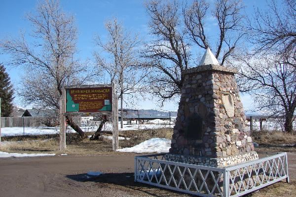
| 590 | Bear River Massacre | Highway 91 / Hot Spring Road | Preston | Franklin, Idaho | N 42.14076 W 111.91131 | |
| 591 | Atkinville | 1211 W Copeland Dr | St. George | Washington, Utah | N 37.02335 W 113.60940 | |
| 592 | Clarkston Tithing Granary | 88 W Center St | Clarkston | Cache, Utah | N 41.91996 W 112.05331 | |
| 593 | Mapleton Ward Relief Society Hall | 125 S Main St | Mapleton | Utah, Utah | Distant Close up | |
| 594 | Pleasant Green Cemetery | 9200 W 3500 S | Magna | Salt Lake, Utah | Distant Close up | N 40.69469 W 112.11046 |
| 595 | Fremont School Bell | Fremont | Wayne, Utah | Distant Close up | N 38.45730 W 111.62157 | |
| Non-numbered markers below: | Non-numbered markers below: | Non-numbered markers below: | Non-numbered markers below: | |||
| Bear River City Pioneers | 4549 West 5900 North | Bear River City | Box Elder, Utah | Distant Close up | N 41.61625 W 112.12314 | |
| The Bell (Oak City) | 1 North Main St | Oak City | Millard, Utah | Distant Close up | N 39.37523 W 112.33636 | |
| Build South and West | 106 East 200 North | Cedar City | Iron, Utah | Distant Close up | N 37.68074 W 113.05996 | |
| Donner Party Route | 2045 East 1300 South | Salt Lake City | Salt Lake, Utah | Distant Close up | N 40.74173 W 111.83240 | |
| Fremont Rock Church House | 285 West Center Street | Fremont | Wayne, Utah | Distant Close up | N 38.45730 W 111.62157 | |
| Hanksville Rock Meeting House | 10 South Center Street | Hanksville | Wayne, Utah | Distant Close up | N 38.37254 W 110.71491 | |
| Hatch Ward Building & Bell | 24 South Main St | Hatch | Garfield, Utah | Distant Close up | N 37.64913 W112.43465 | |
| Orderville Bell | 110 E State St | Orderville | Kane, Utah | N 37.27582 W 112.63596 | ||
| Paragonah Town Square | 31 North Main St | Paragonah | Iron, Utah | Distant Close up | N 37.88648 W 112.77526 | |
| Roosevelt Bell | 28 W Lagoon St | Roosevelt | Duchesne, Utah | N 40.29962 W 109.99232 | ||
| Wayne Theatre | 11 East Main St | Bicknell | Wayne, Utah | |||
| Willard Central School Bell | 80 West 50 South | Willard | Box Elder, Utah | Distant Close up | N 41.40839 W 112.03854 | |
| Union Fort and the Chase Mill | Salt Lake, Salt Lake, Utah |
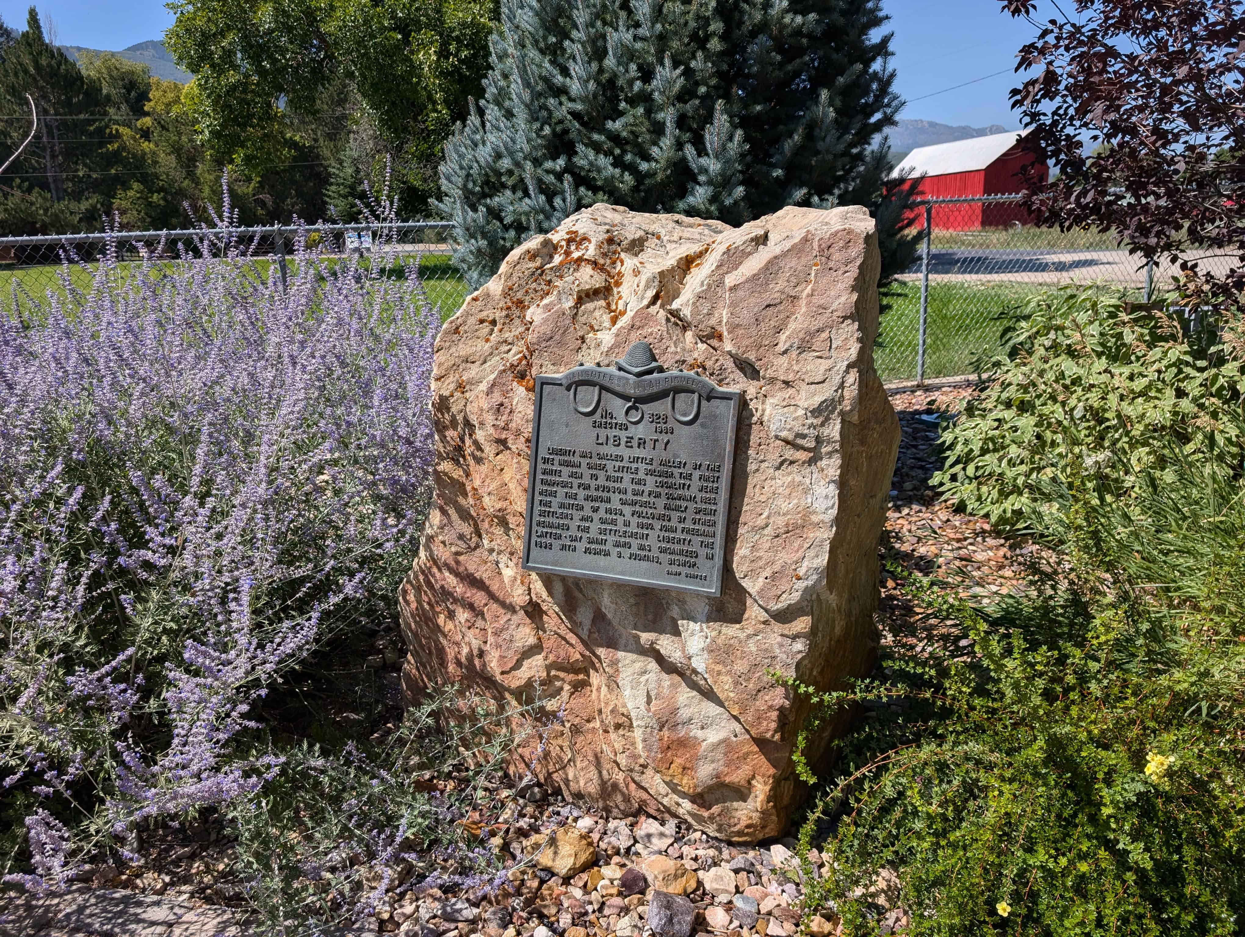
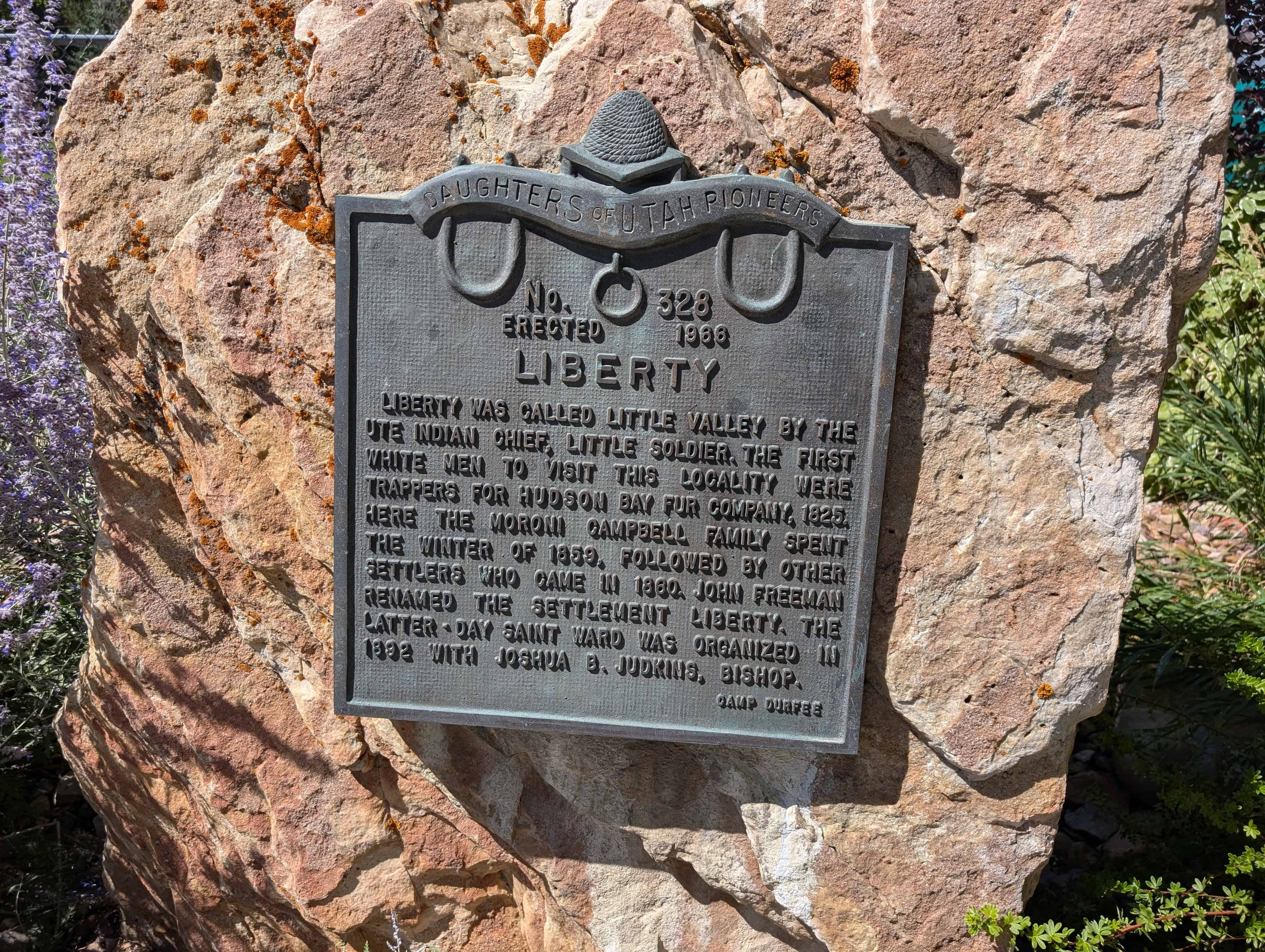
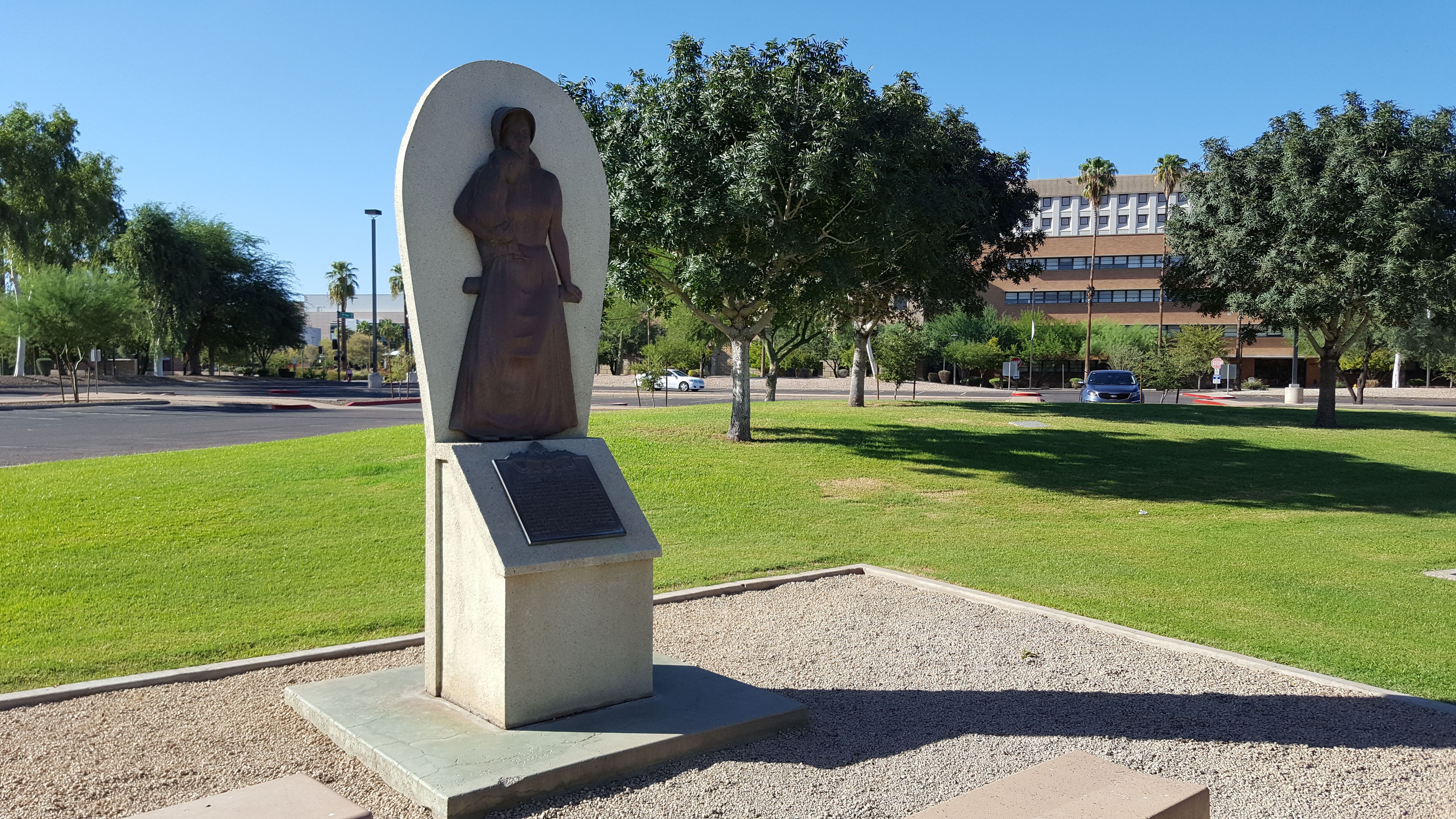
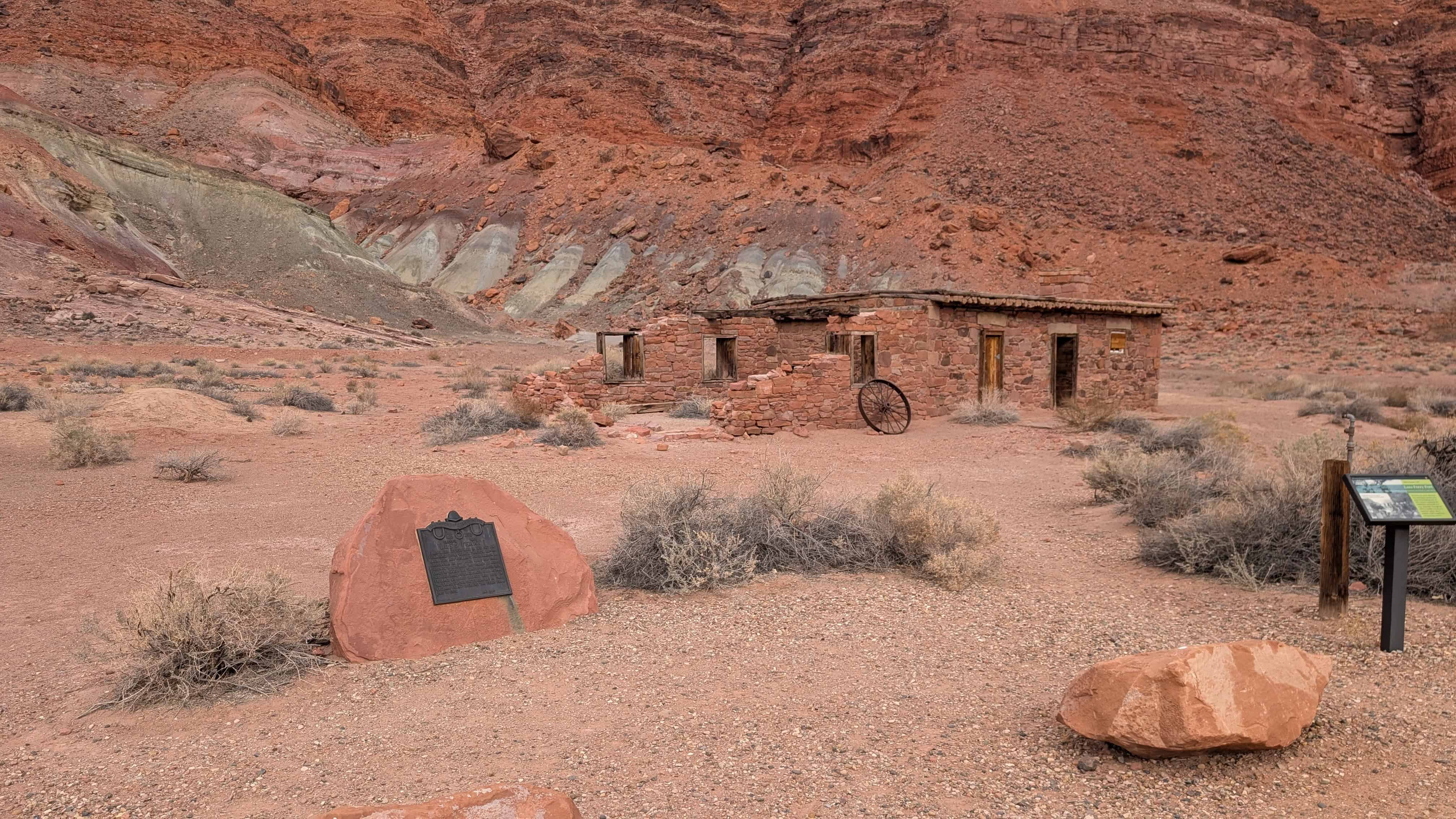
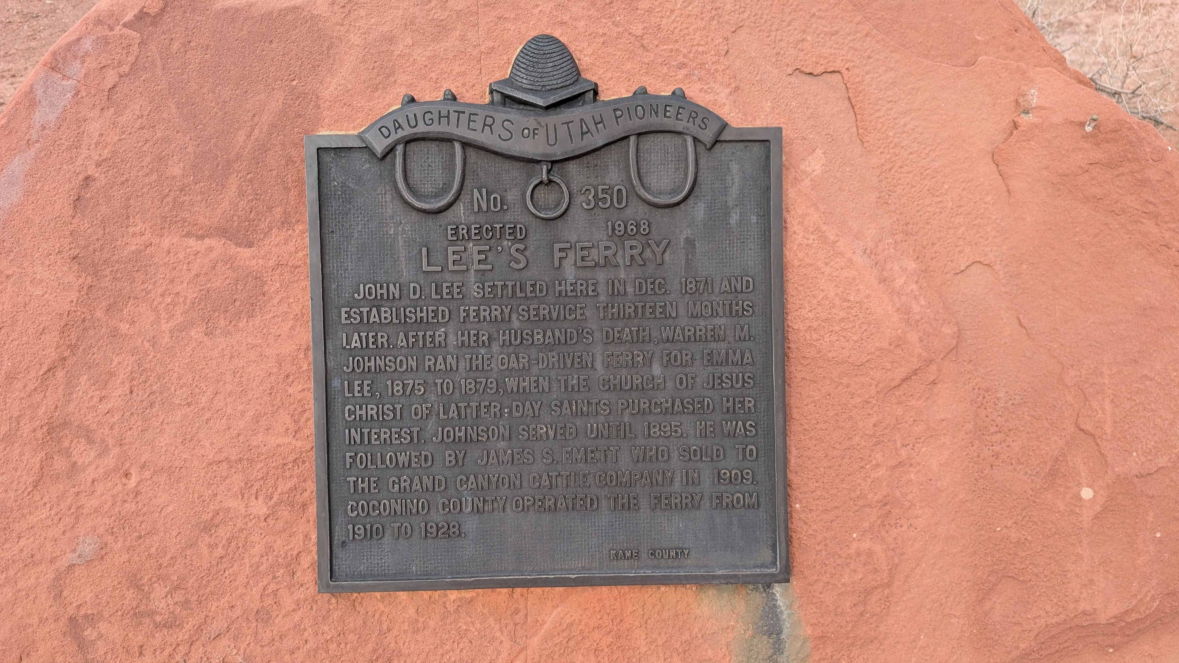
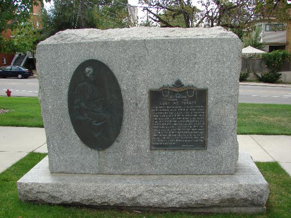
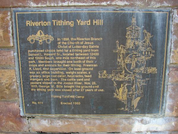
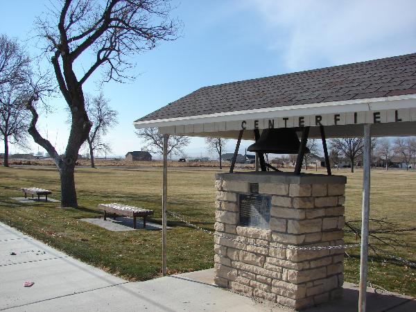
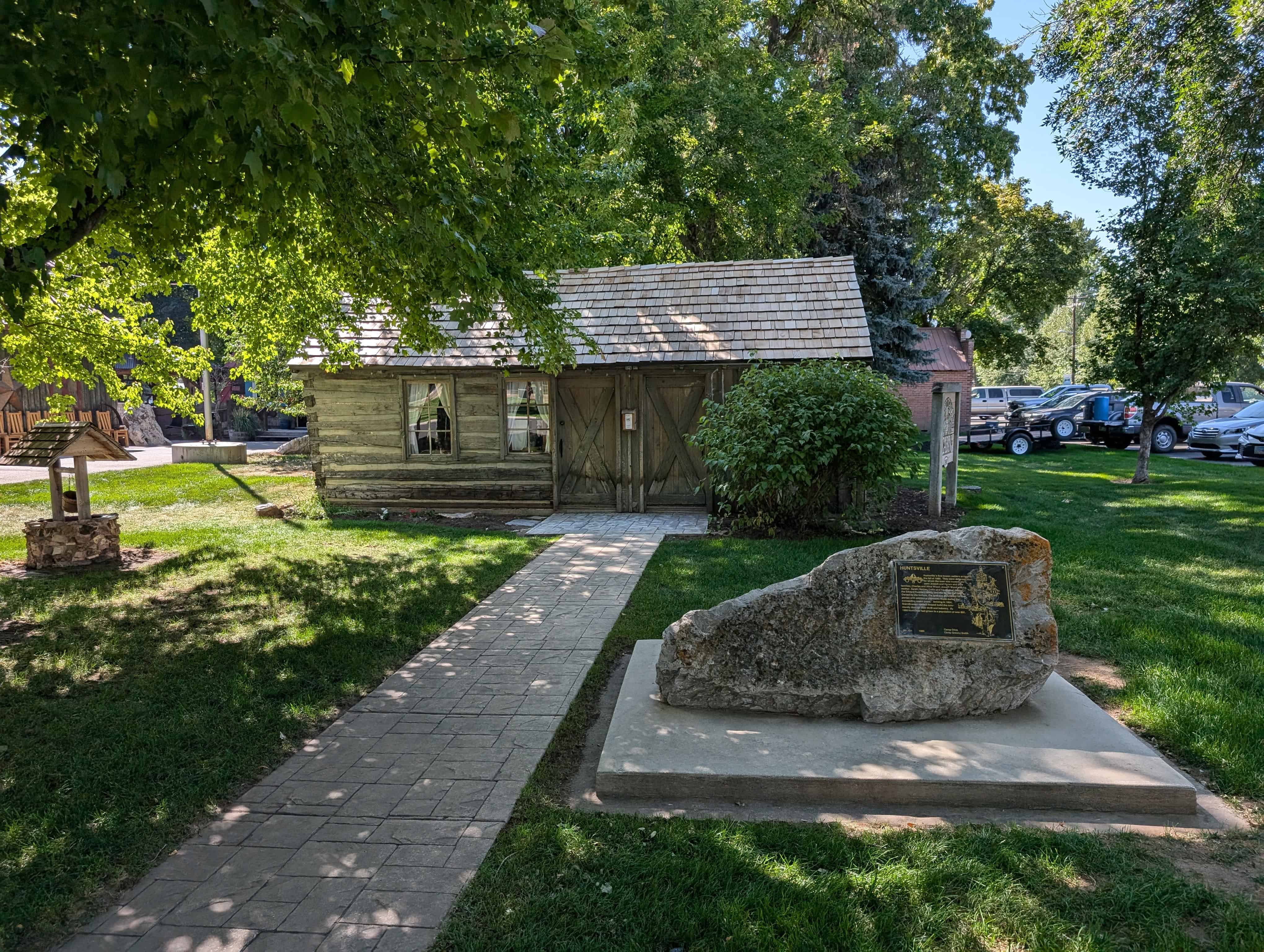
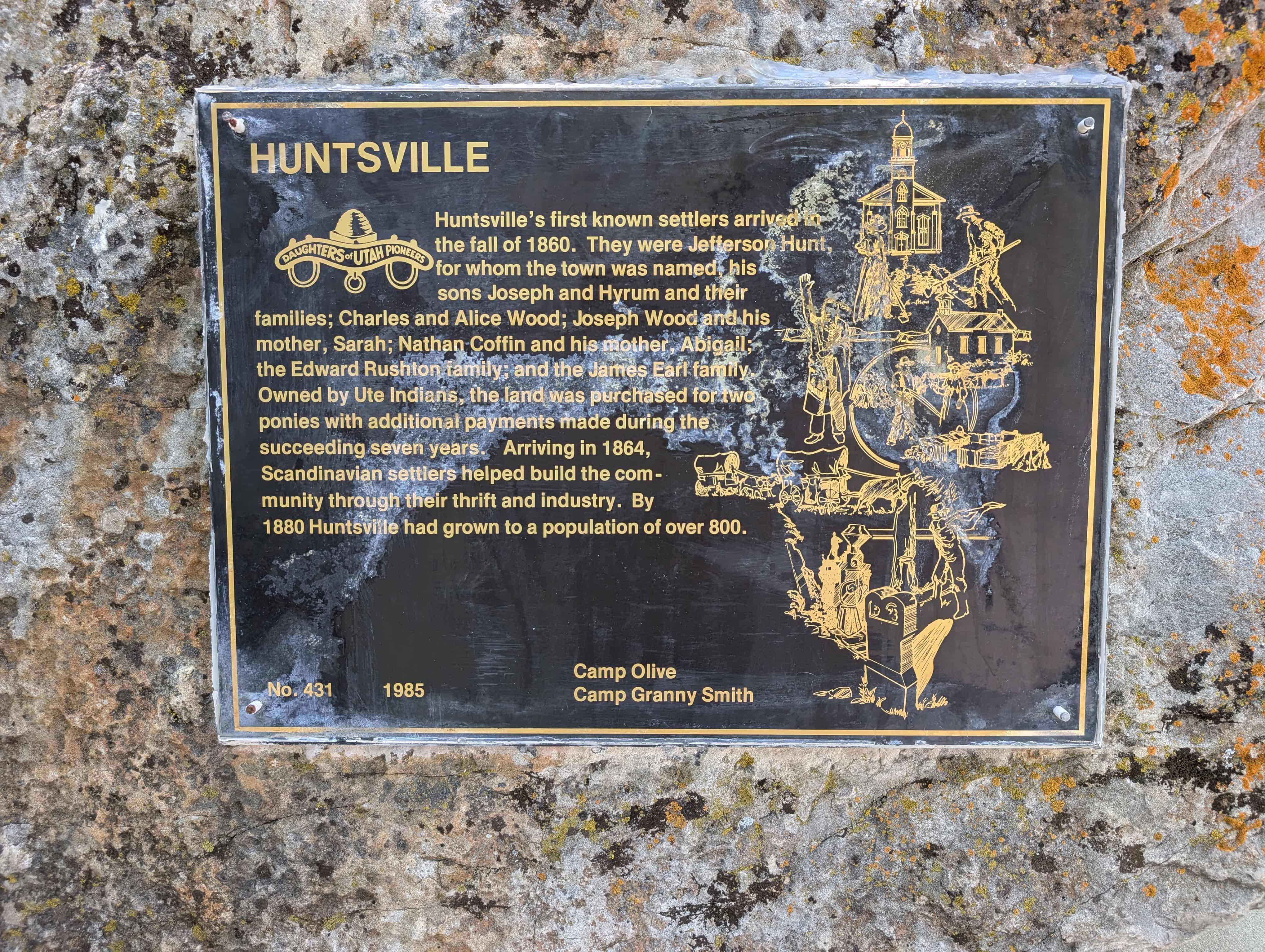
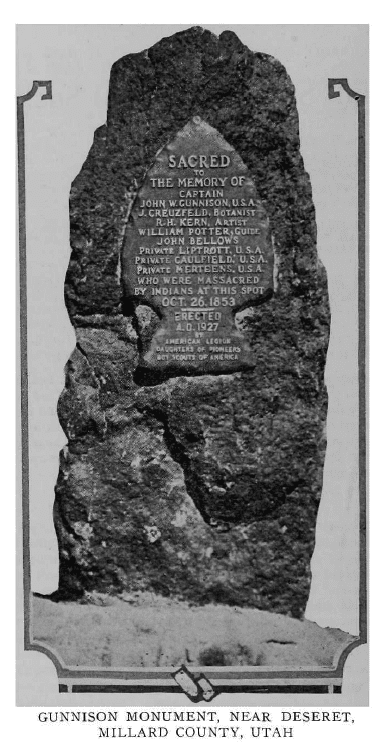
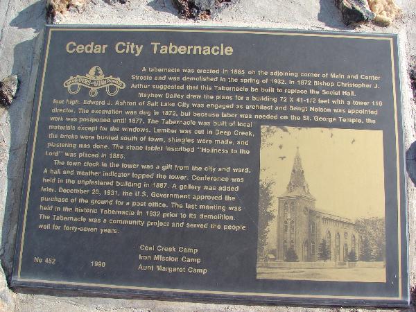
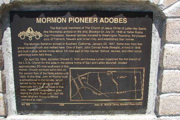
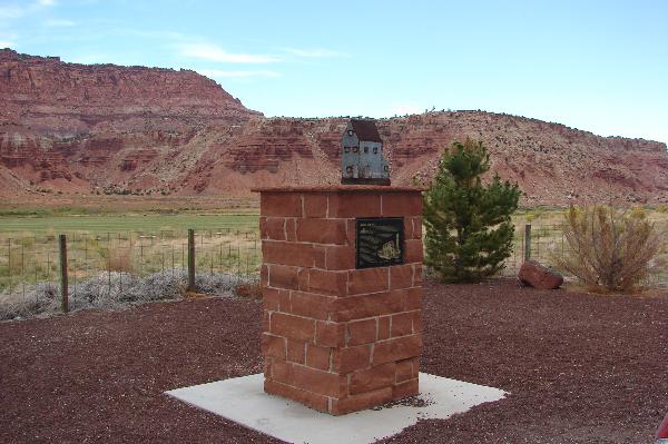
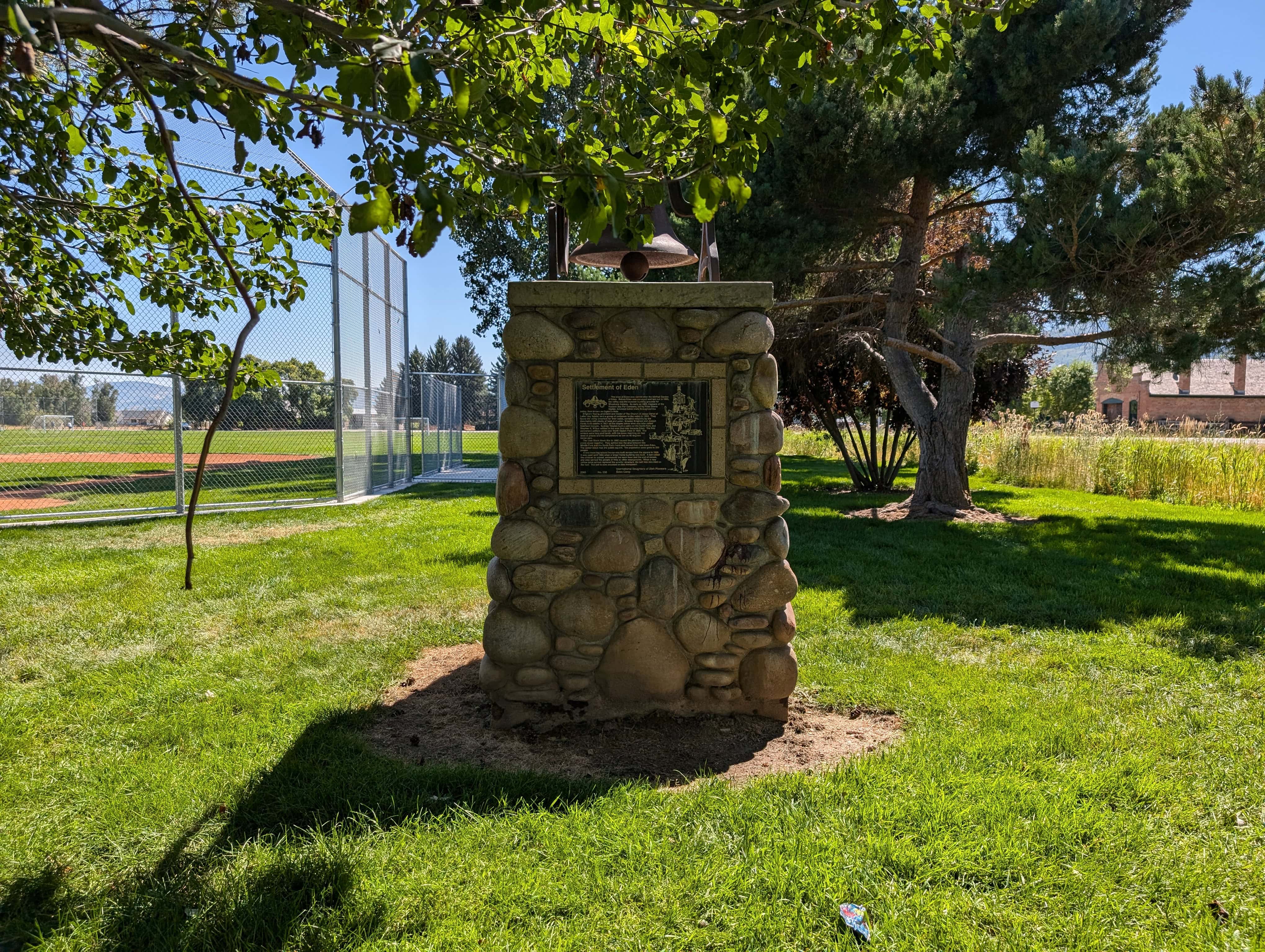
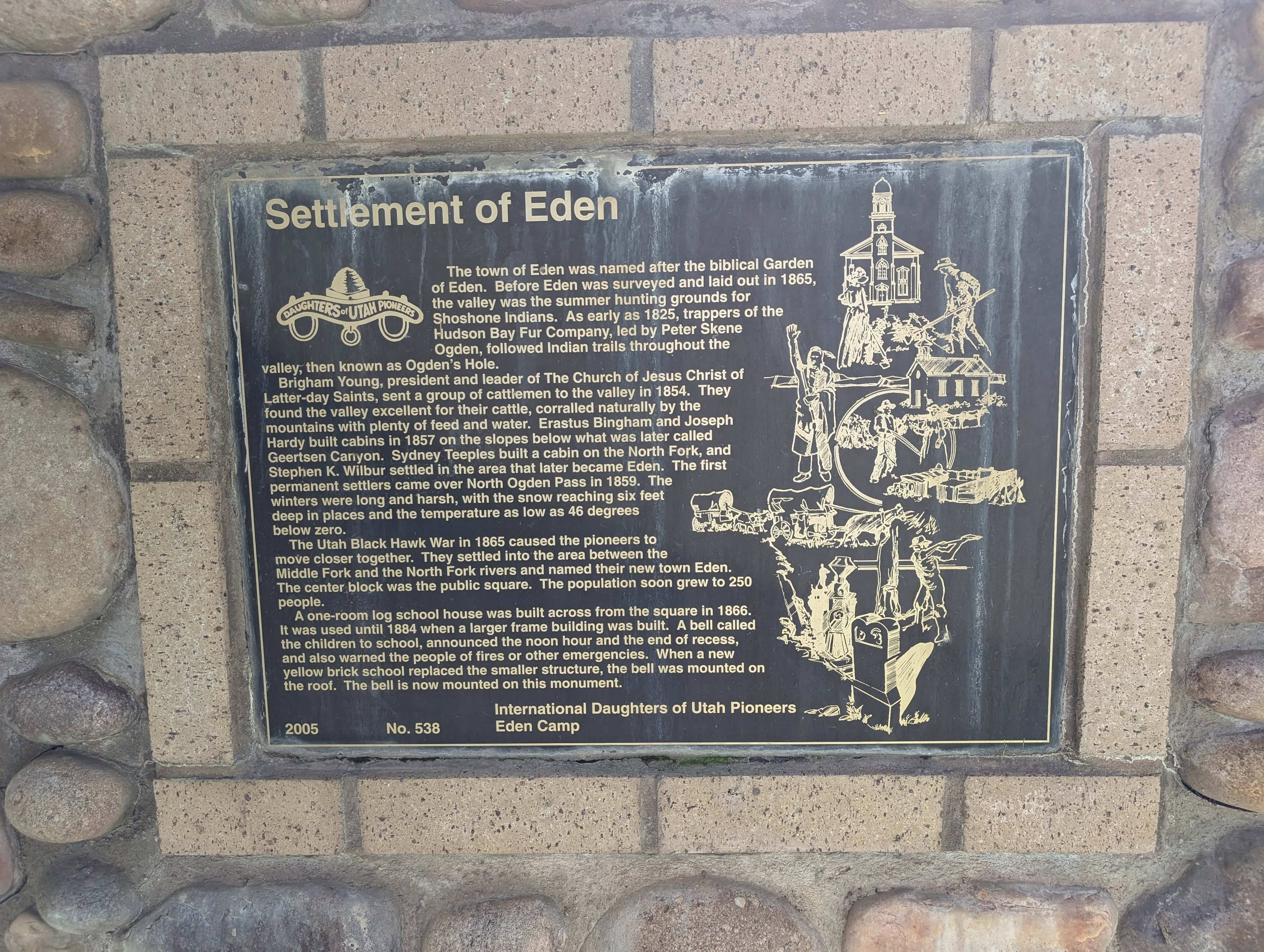
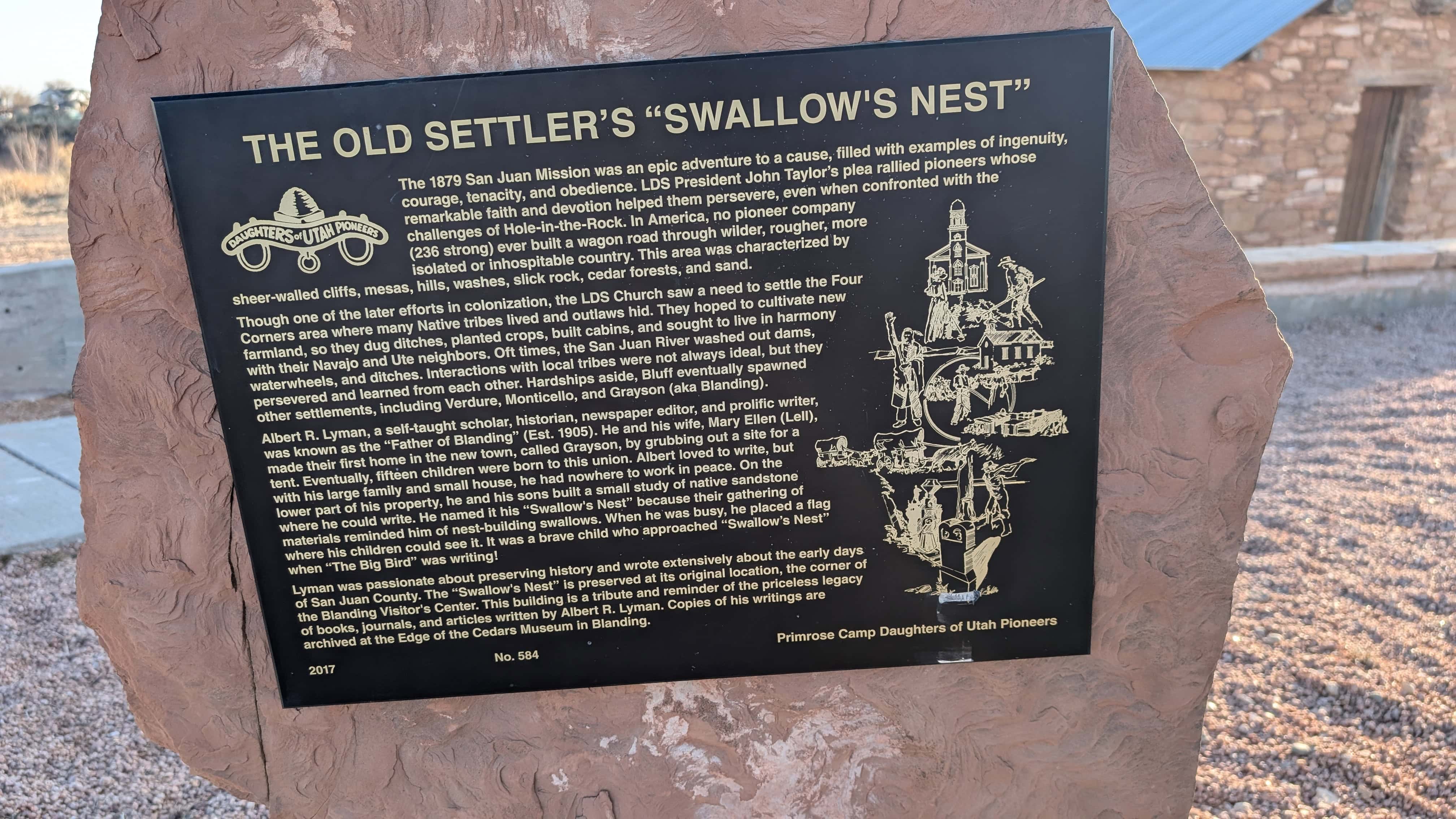
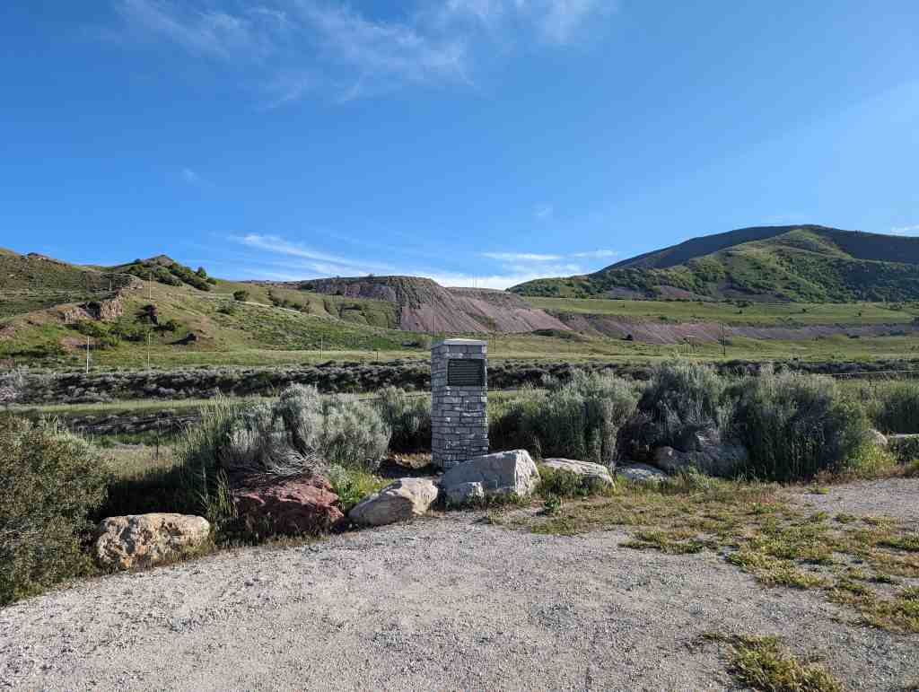
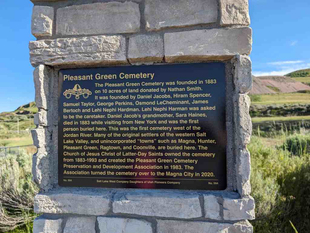
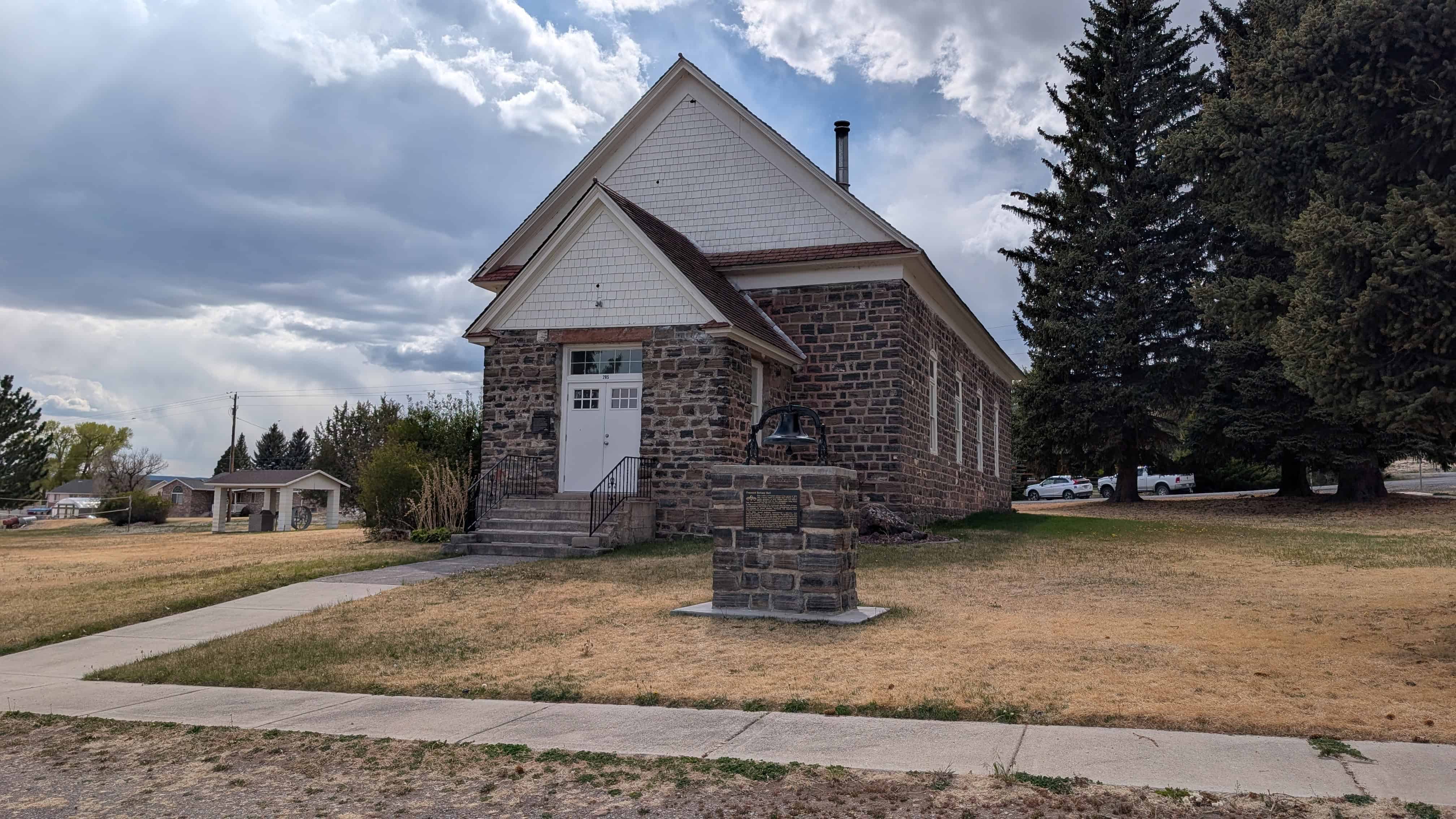
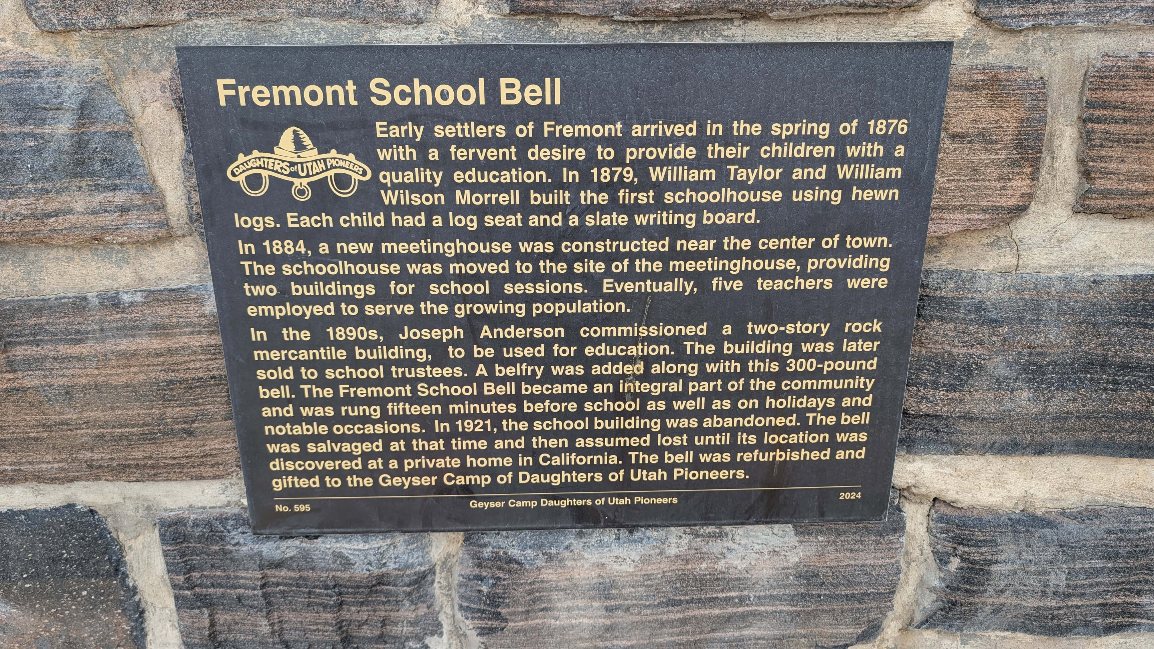
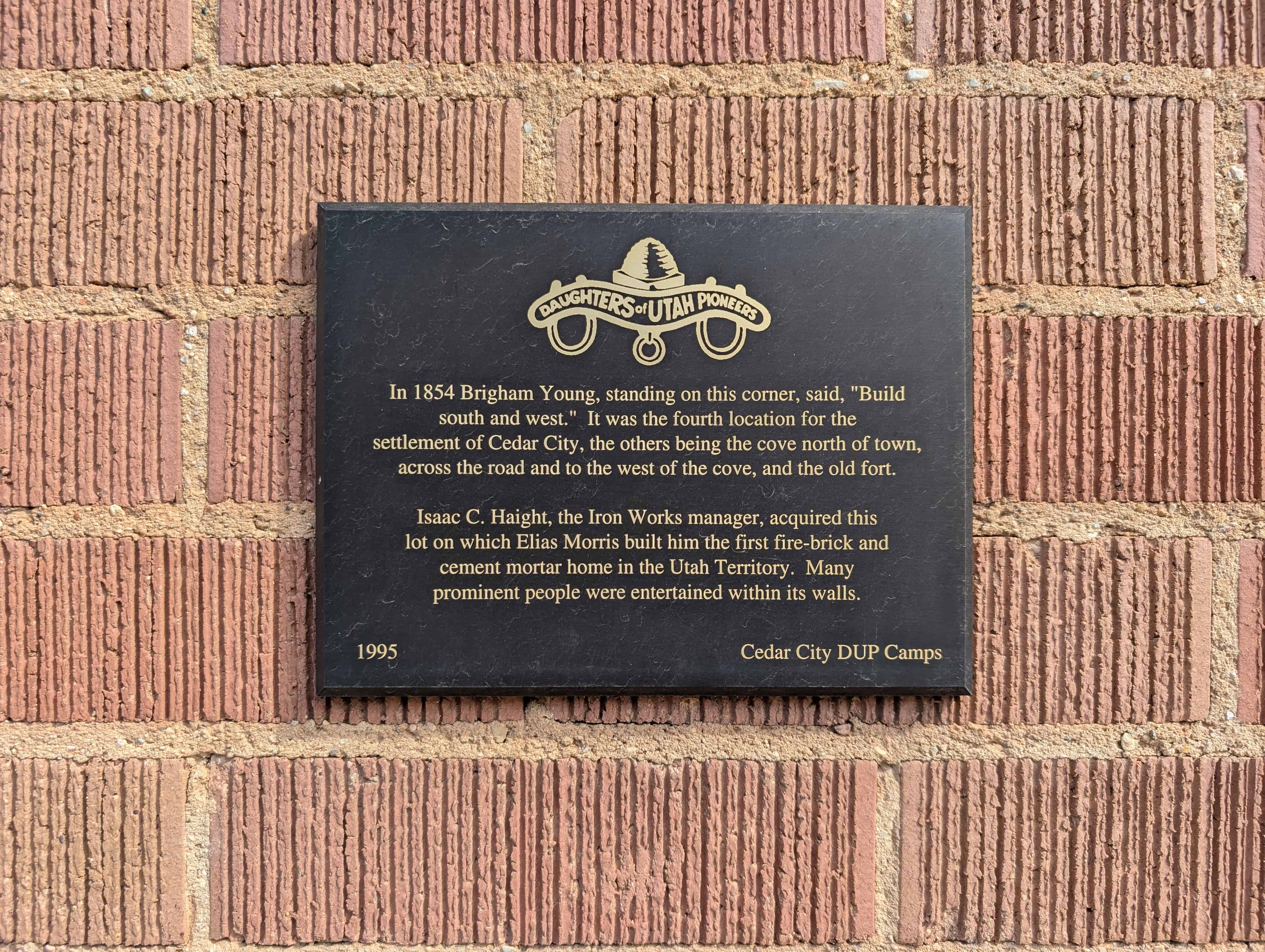
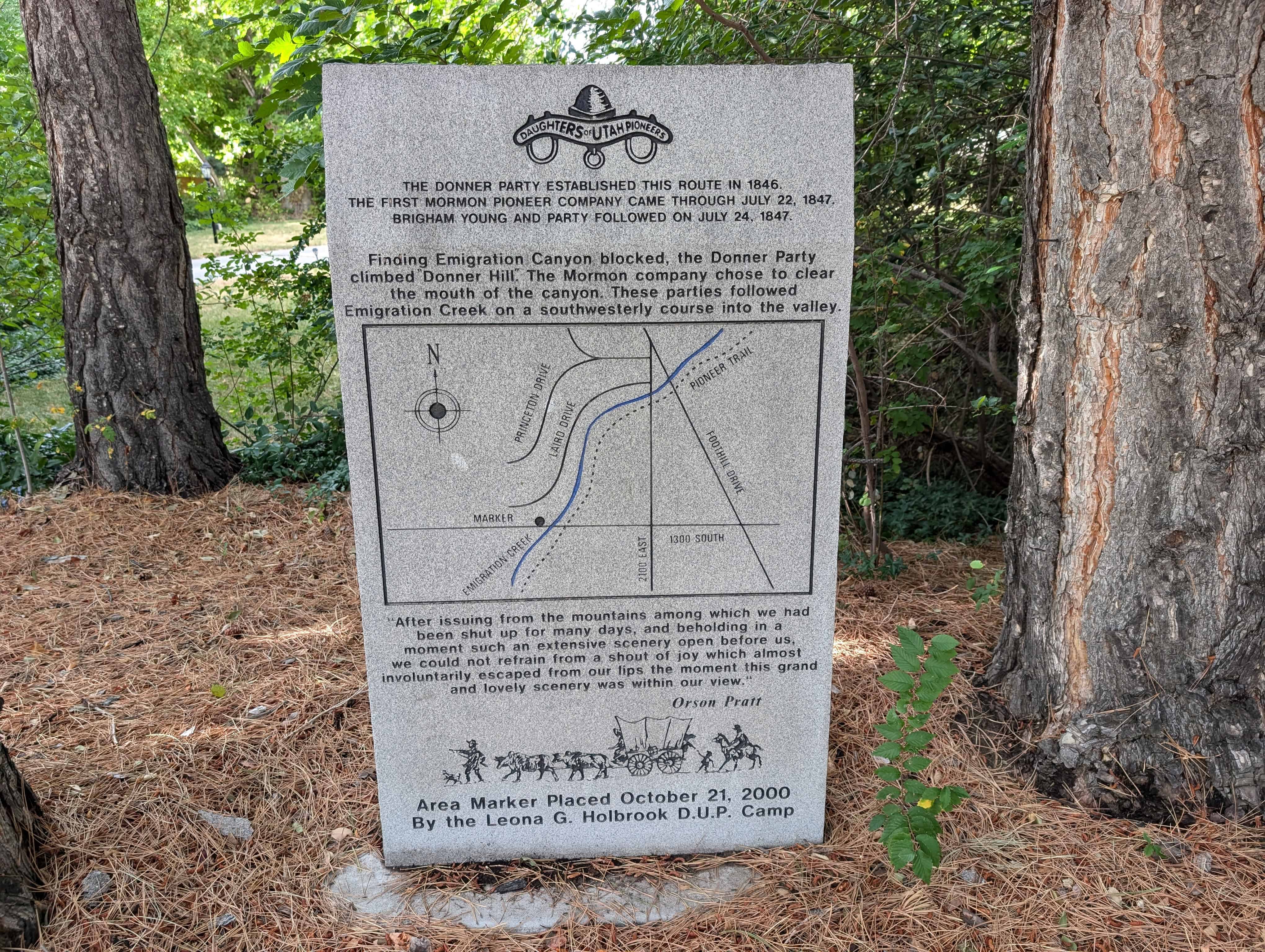
Pingback: Taylor Settlement | JacobBarlow.com
Pingback: Cedar Point – Basalt | JacobBarlow.com
Pingback: Rexburg’s First School and Meetinghouse | JacobBarlow.com
Pingback: Ricks College | JacobBarlow.com
Pingback: Early Settlements | JacobBarlow.com
Pingback: Weston Pioneers | JacobBarlow.com
Pingback: Old Tithing Office | JacobBarlow.com
Pingback: Our First Church | JacobBarlow.com
Pingback: Thomas Sleight Cabin | JacobBarlow.com
Pingback: St. Charles | JacobBarlow.com
Pingback: Settlement of East Carbon | JacobBarlow.com
Pingback: Shelley Settlement | JacobBarlow.com
Pingback: Bear River City Fort | JacobBarlow.com
Pingback: The Old Settler’s “Swallow’s Nest” | JacobBarlow.com