

U.P.T.L.A. Historic Marker #59
Established May 9, 1854, by John D. Lee, Richard Woolsey, William R. Davis and others who had founded Harmony in 1852. County seat of Washington County until 1859. Headquarters of Mormon Mission to Lamanites 1853 -1854.
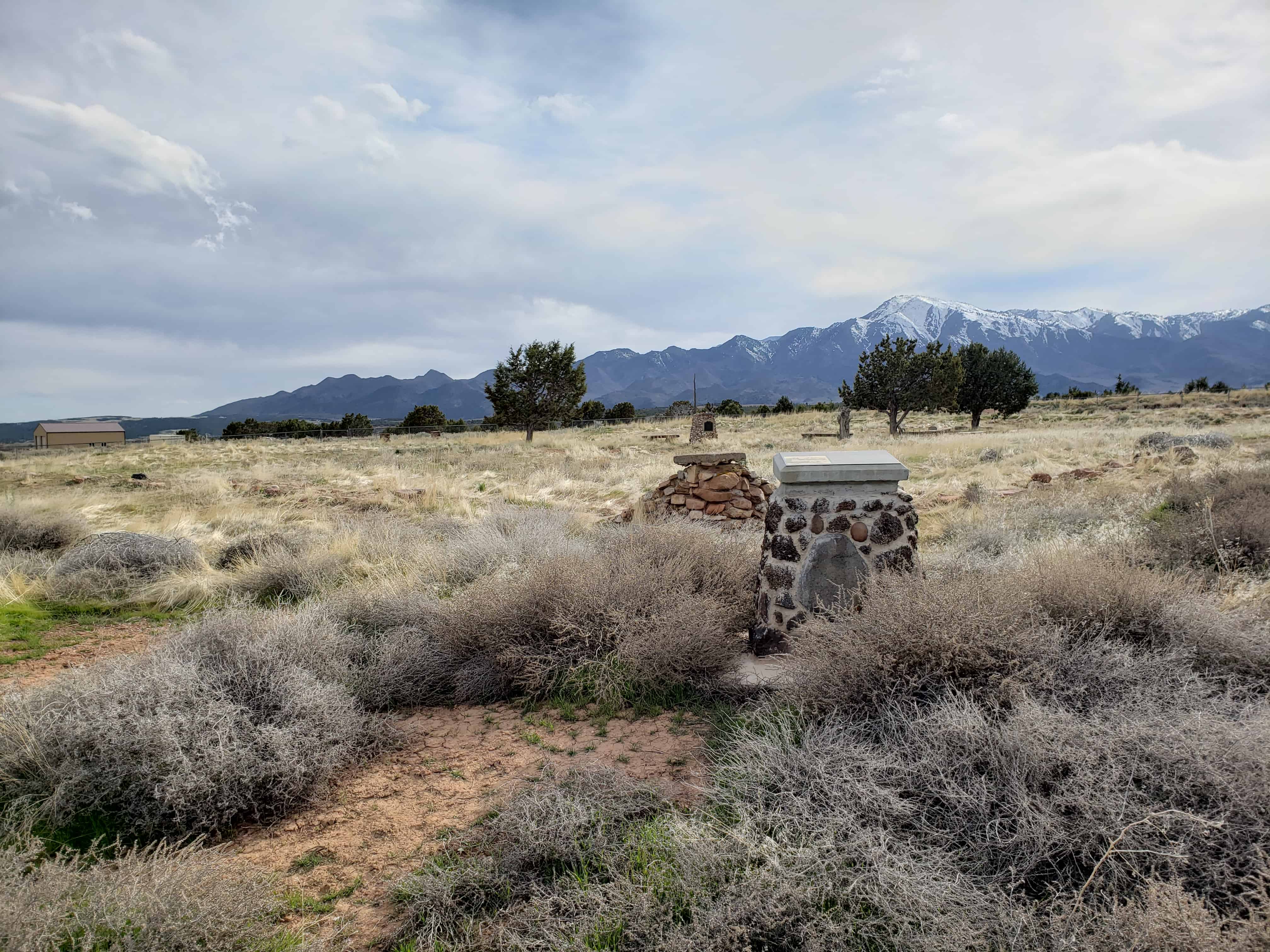
The fort was finally abandoned in February 1862, following heavy storms that caused the walls to crumble and fall, the settlers founding New Harmony and Kanarraville. The wall was 300 feet square. Houses on east side were one story and wall 10 feet high; on west side two stories and wall 16 feet high. Kanarra and Harmony Creeks supplied water for irrigation.
Utah Pioneer Trails and Landmarks Association and Members of Parowan Stake.

Related Posts:
S.U.P. Historic Marker #172
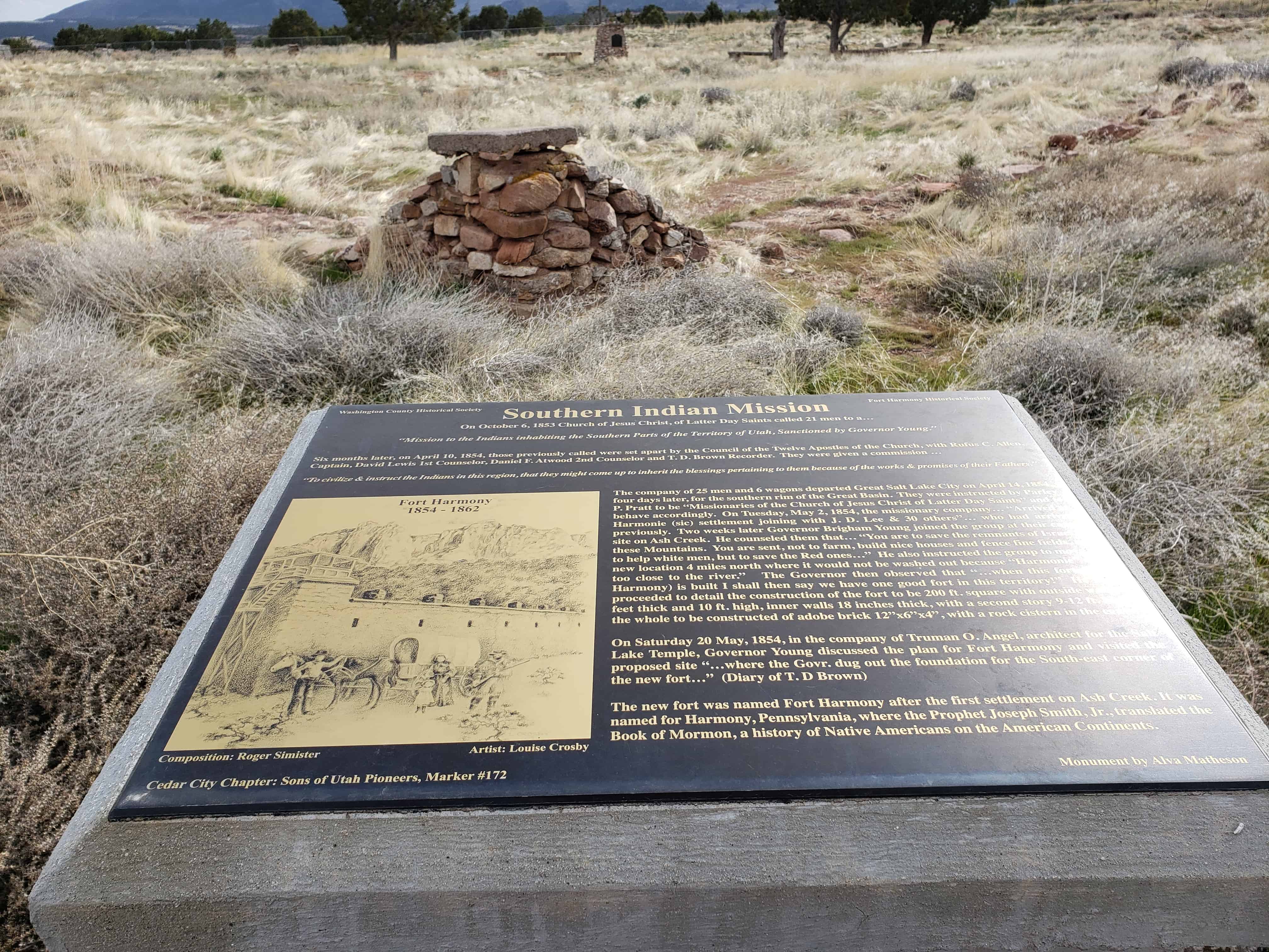
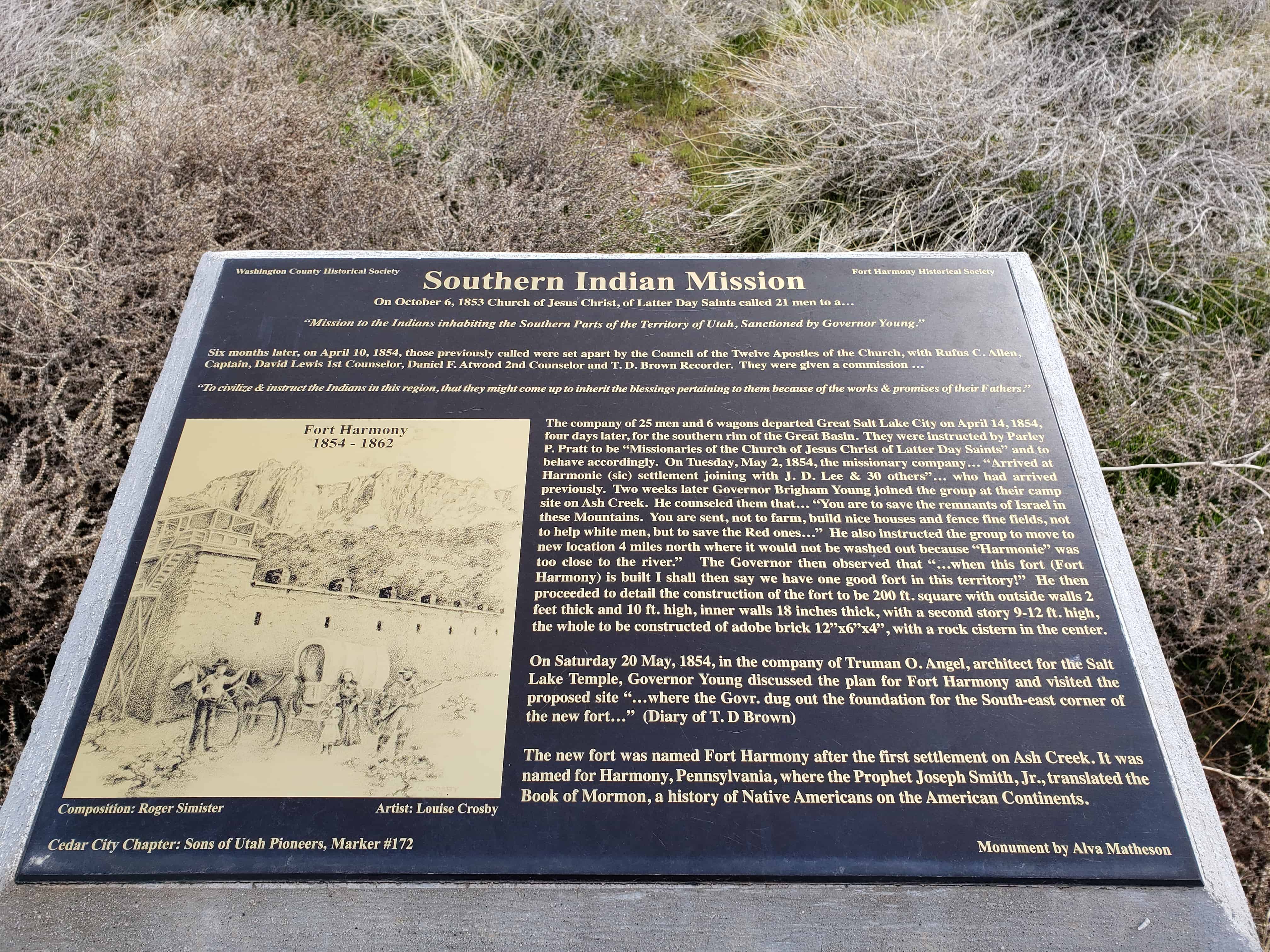
Southern Indian Mission
On October 6, 1853, The Church of Jesus Christ of Latter-day Saints called 21 men to a “Mission to the Indians inhabiting the Southern Parts of the Territory of Utah, Sanctioned by Governor Young.“
Six months later, on April 10, 1854, those previously called were set apart by the Council of the Twelve Apostles of the Church, with Rufus C Allen, Captain, David Lewis 1st Counselor, Daniel F. Atwood 2nd Counselor and T.D. Brown Recorder. They were given a commission “To civilize & instruct the Indians in this region, that they might come up to inherit the blessings pertaining to them because of the works & promises of their Fathers.“
The company of 25 men and 6 wagons departed Great Salt Lake City on April 14, 1854, four days later, for the southern rim of the Great Basin. They were instructed by Parley P. Pratt to be “Missionaries of the Church of Jesus Christ of Latter-day Saints” and to behave accordingly. On Tuesday, May 2, 1854, the missionary company “Arrived at Harmonie (sic) settlement joining with J.D. Lee & 30 others” who had arrived previously. Two weeks later Governor Brigham Young joined the group at their camp site on Ash Creek. He counseled them that “You are to save the remnants of Israel in these Mountains. You are sent, not to farm, build nice houses and fence fine fields, not to help white men, but to save Red ones.” He also instructed the group to move to a new location 4 miles north where it would not be washed out because “Harmonie” was too close to the river.” The Governor observed that “when this fort (Fort Harmony) is built I shall then say we have one good fort in this territory!” He then proceeded to detail the construction of the fort to be 200 feet square with outside walls 2 feet thick and 10 feet high, inner walls 18 inches thick, with a second story 9-12 feet high, the whole to be constructed of adobe brick 12″ x 6″ x 4″, with a rock cistern in the center.
On Saturday, 20 May, 1854, in the company of Truman O. Angell, architect for the Salt Lake Temple, Governor Young discussed the plan for Fort Harmony and visited the proposed site “…where the Govr. dug out the foundation for the South-east corner of the new fort...” (Diary of T.D. Brown)
The new fort was named Fort Harmony after the first settlement on Ash Creek. It was named for Harmony, Pennsylvania, where the Prophet Joseph Smith, Jr., translated the Book of Mormon, a history of Native Americans on the American Continents.


Fort Harmony was important as one of the first settlements of Southern Utah. It was founded by John D. Lee, one of the most interesting and controversial figures in Mormon history. The fort served as a stopping place for travelers en route from Salt Lake City to California. The construction materials used in the fort – adobe – illustrates the lack of adequate building materials for many Mormon settlements. It also illustrates the faith of Brigham Young and his followers that adobe would prove “satisfactory. However, the destruction of the adobe fort by the elements in 1862 did not end the use of adobe as a building material. While little remains of the original fort, the site could produce important archaeological information if and when the site can be satisfactorily and scientifically studied for information on the early Mormon occupation of the area.
The Journal History of the Church for May 20, 1854 provides the following description of Fort Harmony and an account of the beginning construction work: At 11 a.m. Pres. B. Young dug up the first sod to locate the southeast corner of the fort which is intended to be 200 feet long, 21 feet high and to form the outside of the houses. The lower rooms ^ to be three feet thick and the upper rooms two feet thick. The windows to be three and a half feet above the upper floor. The walls on the inside of the fort 18 inches thick.
According to the historical marker placed at the site by the Daughters of the Utah Pioneers, the fort was 300 by 300 feet at its completion; the western walls were 16 feet nigh and western houses were two story; and the eastern walls were 11 feet high. The houses on that side were only one story. Houses inside the fort were located with their racks against two walls.
The fort had two gates on the north and south. (These gates as well as the corners of the fort are marked by monuments of rock and cement erected by the residents of New Harmony and Kannarraville in 1936). A well was located in the center of the fort. It was constructed of adobe brick with some rock used in the foundation. The same adobe-wall and stone-foundation construction was used in the houses and walls of the fort.
Fort Harmony was literally washed away in the great storm of 1861-1862. The torrents disintegrated and destroyed the adobe walls. Currently, only traces of the foundation remains. The fort is superficially in an extremely deteriorated condition. However, the archaeological potential is significant. As is indicated on the attached sketch map, depressions and slight rises exist which suggest the presence of archaeological remains. On the west side, the terrain rises about one meter to the postulated wall level. It may be that the western wall and son e of the interior walls of the western houses remain at a considerable height. Similarly, in the east and south sections of the fort, interior foundations are visible. These consist of one or two walls of local red sandstone, approximately 1.5 meters from the exterior wall. As can be seen on the sketch map, the interior foundations correlate with rises and depressions within the fort. These indicate the possible presence of walls, structures, and dugouts which would be archaeologically recoverable.
The site and its environs are covered by thick sagebrush. A few juniper trees grow within the fort itself. Also present are such species as Russian thistle which grow well in disturbed soil. The omnipresent sagebrush camouflages portions of the site and adjacent areas and discourages casual vandalism. Unfortunately, the vegetation may also hinder professional investigation. Although brief surveys could find no indications of structures outside the fort walls, the settlement was occupied long enough (eight years) so that such extra-site phenomena should be expected. However, for the moment, no such structures or activity areas have been identified so that nominated area is restricted to the fort itself.
The History
Following the arrival of the first Mormon Pioneers in Utah in 1847 exploring parties were sent out to assess the resources of the area. Of special importance was the location of iron and coal deposits of sufficient quality that the Mormons could develop their own iron industry, thereby insuring they would not be dependent upon outside sources for manufactured goods. In November 1849, an exploration party under the leadership of Parley P. Pratt left to explore southern Utah. Approximately two hundred fifty miles south of Salt Lake City they discovered a hill of rich iron ore. Brigham Young responded quickly to the report and in July 1850 a call was issued for an advance party to journey to the Little Salt Lake Valley to make preparations for a large number of immigrants who would be sent the following spring to develop the iron resources. In December 1850 the advance party of 119 men, 30 women and 18 children began the journey southward.
Among the advance party was John D. Lee, a member of the Council of Fifty, the political governing organization within the church. Lee’s assignment was to assume a leading role in the establishment of settlements which would produce food for the anticipated miners and mill workers.
It was proposed in October 1851 that John D. Lee establish a settlement at the junction of the Rio Virgin and Santa Clara Rivers where dates, figs, grapes and cotton could be raised. However, because of the need to strengthen the settlement of Parowan, Lee was instructed to remain there.
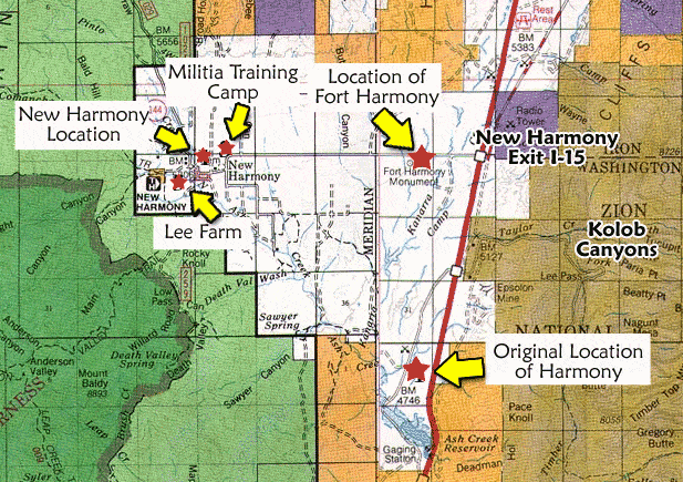
In the summer of 1852, Lee established a fort on Ash Creek in which he built six houses or rooms along the wall of the fort for his six wives. However, the site did not have sufficient farmland and in 1854 the location was abandoned and Fort Harmony constructed with Brigham Young digging the first sod to be used in the fort on May 20, 1854.
Other settlers joined John D. Lee and his family at Fort Harmony and on January 4, 1856 the citizens of Washington County sent a petition signed by thirty-two men, the total male population, requesting they be permitted to establish an autonomous county government with Fort Harmony, then the only settlement, as the county seat. The petition was granted by-the Territorial Assembly. John D. Lee was elected Probate Judge, Clerk and Assessor.
Fort Harmony not only served to house the Lee family and other settlers, but was also used as a stopping place for travelers following the southern march from Salt Lake City to Southern California. This route avoided the dangerous Sierra-Nevada Mountains and was used primarily during the winter months. Juanita Brooks reports: “Because of the long desert stretch to the south, the overland travel was made during the winter months and most of the wagons stopped at Harmony. At thirty-one cents a meal and the same per head for a night’s feed for cattle, Lee took in from twenty to seventy-five dollars a night, depending upon the size of the train. There were nights when Aggatha, Emma, Rachel, and Terresa (his wives) cooked most of the night to serve travelers. Ten horsemen who had their feet frostbitten stopped several days; then hired Lee’s wagon to take them as far as Washington at a cost of thirty dollars for the group. One large group stayed so long that he took in a total of one hundred and seventy-five dollars.”
The prosperous business venture at Harmony came to an end after 1862 when a tremendous series of rain and snow storms melted the adobe walls of the fort in December 1861 and January 1862. The settlers were forced to abandon the fort but not before two of John D. Lee’s children, George Albert, age six and Margarett Ann, age five were killed when a wall fell on the sleeping children.
As President of the Harmony Branch, John D. Lee recorded in the branch records the following account of the rain and tragedy.
“Sunday, Dec. 29, 1861. Meeting in Prest. J. D. Lee’s family hall at 10 a.m. Through the week the storms still raging; prospects dark and gloomy; the Earth a sea of water and thus closes 1861.
Jany. 1st, 1862. Begins with a storm. The face of the country is deluged with water.
Sat., Jan. 4, 1862. Snow about 8 inches deep. Fort Harmony /built, as were the houses, chiefly of adobe brick/ is almost decomposed and returned back to its native element.
Elder Lee and a portion of his family have suffered severly during the storm as they were trying to make shelters at their new location: the water in their underground rooms raised to a depth of 3 feet. Bailing night and day, but unable to keep it out and were at last compelled to abandon them and take the storm in shantys made of planks; (wind shifted North). During the entire storm the wind was south but when it changed the weather became severe, yet they thought better to suffer than to risk being buried up alive in Fort Harmony.
Harmony. Teus (sic) 7, 1863 /1862/. Snowy through the day.
Thurs., Jany. 9, 1862. Snow 10 inches deep.
Sunday, Jany. 13, 1862. The storm still raging, spreading a mantle of gloom over Harmony, the walls of which are constantly crumbling down, rendering the houses actually dangerous altho a short time previous Prest. B. Young said it was the best Fort ever built in the Territory; instead of meeting, Prest. Lee summoned another portion of his family to the upper place. About 9 at night a dreadful snow storm on them.
Monday, Jany. 14, 1862. The storm most vehemently raging. About 1 P.M. Prest. Lee’s barn fell, the side had been washed out several days before and the timbers alone supported it; Several Horses, Calves, and hogs were in it when it fell but nothing was hurt.
The S. side is expected to fall before morning. The Pres. removed the remainder of his family on the west line and spent another night of gloom and darkness; parts of walls constantly falling. This was a time of watching as well as praying, for there was a prospect of being buried in masses of ruins; about midnight a part of the South wall fell with an awful crash. Killed 2 chickens only. At length daylight came. Storm still raging.
Sat. Jan. 18 /19/, 1862. Pres. Lee through the kindness of Wm. and Harvey A, Pace, also Geo. M. Sevy, manned 3 wagons with 8 yoke of catle (sic) to each wagon (as the axletree would in places drag the ground) and removed all the families from the Fort except Sarah C. Lee and family. Her house was considered safe and the only place of refuge where all the families staid the night previous; the storm unabating, Pres. Lee was 8 days without undressing or putting on dry clothes. The families were removed through the storm, women and children soaking wet.
Reports say that the Rio Virgin and Santa Clara rivers were overflowing the country and doing much damage. The mill of Jacob Hambiln’s and City were washed away, orchards and vineyards desolated. The towns o£ Adventure, Rockville, Grafton, and Pocketsville were all destroyed. Bishop P. K. Smith of Adventure had his house, Cane mill, Blacksmith shop, 150 Gals, molasses and much of his household and kitchen furniture was down the flood. Bishop N. C. Tenney lost his houses and furniture and loosing a part of his family.
Monday, Jany. 27, 1862. Cloudy. W.N. Evening, commenced snowing. Through the night, fell 6 inches deep. Up to
Wen., Jany. 29, 1862, snow 8 inches.
Thurs., Jan. 30, 1862. Rather mild. Rain through the night reduced the snow to 4 inches.
Friday, Jany. 31, 1862. This morning the sun was seen for the first time in 28-1/2 days. At 1 commenced snowing again.
Thurs., Feb. 6th, 1862. Snowing about 10 a.m. Stacked up. Snow about 10 inches. About 1 W. shifted S.E. to N. Cold and cutting. The President had all his family removed except Caroline. Wagons and Teams were all got ready to remove them on the 7th. They would have been removed before had not Sarah Caroline insisted to remain a few days longer to finish up her spinning. Felt there could be no danger as the roof was removed and the rain ceased. Yet the President said that it was not agreeable with his feelings for them to remain there. About dark the mother felt impressed to leave the room. While in the act of making up her bed, leaving the clothes in a chair, took Terressa with her and the two older children, leaving the youngest in. When a few paces from the door, a sudden gust of wind dashed from the N., through /threw/ down a single partition wall into the floor and broke through to the lower floor, killing of the little children, little Geo. A. and Margarett Ann. The other two each was at the feet of the two that was killed. t ,J\. shocking and sad occurrence-the father and mother had both been warned of it previous.
After the destruction of the fort the settlement of New Harmony was established four miles to the west of the fort where Lee had already begun construction of another home. In reality Fort Harmony was ready to be abandoned before it was destroyed by the rains. However,, Fort Harmony served as a home for John D. Lee during seven crucial years of his life. It was an outpost which played a key role in the Mormon settlement efforts in Southern Utah. It was a major stopping place on the Salt Lake City to Southern California overland route and provided for John D. Lee considerable income as the fort was used as an inn for travelers on the overland trail. Finally it was the home of John D. Lee when the infamous Mountain Meadows Massacre occurred. John D. Lee who, with other Mormon settlers in the area, participated in the killing of an immigrant party bound for California in 1857 was eventually executed for his participation in the massacre.
After the fort site was abandoned, it was acquired as a homestead by Andrew G. Schmutz, and is still in the Schmutz family.
Related Posts:
- National Register of Historic Places
- www.fortharmony.org/
- http://www.wchsutah.org/towns/new-harmony.php
Two photos I got from this website.

Pingback: Harmony, Utah | JacobBarlow.com
Pingback: New Harmony, Utah | JacobBarlow.com
Pingback: Washington County | JacobBarlow.com