Home to many petroglyphs from the native tribes that have lived in Utah for thousands of years.
The Canaan Gap Archaeological District is located west of Hildale, Utah and was added to the National Register of Historic Places (#100011576) on March 28, 2025.
The Grotto Camping Ground North Comfort Station is located in Zion National Park in Washington County, Utah and was added to the National Historic Register (#86003705) on February 14, 1987.
Shoal Creek area ranchers and Clover Valley residents built a fort here during the Indian War in 1866. Later a village developed consisting of a church/school house, telegraph office, store and about twelve houses. Most residents engage in freighting and stock raising. Residents sold their water and property to the Enterprise Irrigation Company for building the Enterprise Reservoirs. This, floods, drought, disunity and earthquakes brought an end with most residents moving to Enterprise.
(the above text is from a marker by the Cotton Mission Chapter of the S.U.P.
Hebron is in Washington County, Utah west of Enterprise, Utah.
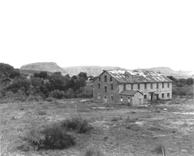
The Washington Cotton Factory was added to the National Historic Register (#71000864) on April 16, 1971 and was located at 385 West Telegraph Street in Washington, Utah. Daughters of Utah Pioneers historic marker #213 talks about it as well. The text below is from the national register nomination form.
(looking east)(looking southeast)
Basic to an understanding of early Utah history is an awareness of the Mormon hope for economic independence and the “mission call.” With early explorations into Utah’s southwest, which discovered the mild climate of the valleys of the Virgin River, a major tributary to the Colorado River the agricultural implications became obvious.
By 1854 an Indian Mission had been established on the Santa Clara River. With cotton seed obtained from Nancy Anderson at Parowan, Angus Hardy, Jacob Hamblin and others planted and grew cotton successfully. Colonists moved south to grow cotton between 1856 and i860. An experimental farm was established at Tonaquint (near Bloomington) in 1858. Washington was settled by “Southerners” led by Bishop Robert D. Covington a year earlier. However, although several thousand pounds were grown during these experimental years, not until the fall of 1861 did Brigham Young call 300 families to the Cotton Mission, the Civil War opened this second phase.
With the erratic Virgin River to supply water for irrigation, the settlers suffered extremely. Floods destroyed dams, leaving no water for partially grown crops. No cotton meant no trade, even for foodstuffs. By 1864 about 74,000 pounds of lint had been sent east to markets. As Young wanted economic independence, he located a factory in “Dixie” to support and encourage the missionaries. “Joseph Birch managed this mill. Brigham sold his factory after five years (1870) to the Rio Virgin Manufacturing Company for $44,000; however, most of this debt was cancelled, since the factory was having such a difficult time.
During this second period, the “Saints” were organized into the “United Order,” a communal economic system. “Orders” from Brigham City on the north and Orderville on the east, sent people to Dixie to grow and process their cotton. Only with the boom of Silver Reef did any real economic relief come to the cotton missionaries, and then mainly to those who grew produce for market at the mines. This diversion, however, slighted the factory’s needs for raw cotton. By 1877, new farms were opened on the lower Virgin River at Bunkerville and Mesquite, Nevada. The St. Thomas area was resettled in the 1880’s and also raised cotton for the factory. Its impact was widespread. Its product and script were used extensively.
Finally, in 1890, Thomas Judd, an important southern Utah merchant, leased the factory and operated it profitably for a few years. By 1898, it was again idle, A few brief attempts at reactivation followed until 1910, when some machinery was sold. In 1914, the rest was scrapped. Since that time, the old mill has served primarily as a warehouse and a haunted house for Halloween dances.
The old cotton factory became the heart of the Cotton Mission. It remains its symbol today. In trying to meet the Saints’ needs for cotton goods under extreme conditions, the L.D.S. Church leaders employed both the “mission call” and the “United Order.” Success was limited. After the Civil War and the coming of the transcontinental rail road, competition from the American “Dixie” increased. The factory’s survival until the turn of the century owes much to the dedication of the cotton missionaries.
On a site originally selected for a mill by James Richy and Benjamin F, Pendleton, Brigham Young and the Dixie settlers constructed their cotton factory.
The large sandstone structure was .begun in1865, with Appleton Harmon assigned as superintendent of construction, Elijah and Elisha Averett, stone masons, and John P. Chidester, chief carpenter. August Mackelsprang and Hyrum Walker supplied lumber from Cedar Mountain. One story was completed and machinery in operation by January 1867. Later, because of expanded demand, including processing of woolen goods, two additional stories were added. By 1870 the enlarged factory was in use.
Located on Mill Creek, west of Washington, central to the cotton producing region, the factory used the water from springs feeding the stream, which was stored in a reservoir west of the mill. Fourteen hours of storage plus the stream flow, would operate the factory for ten hours. At peak production, the factory was capable of producing 500 yards of cloth per day and employed scores of local people. Their production included cotton batts mattresses, quilts, blankets, jeans, denims, broadcloth, flannels and gingham. Problems plagued the factory a supply of cotton and wool, a balanced operation, and lack of a market.
The factory has been empty for years. Fortunately, the roof has been in generally good repair until the last few years. The structure is sound, modified very little and in need of a new roof. It awaits preservation interest, which is now appearing. Its restoration is vitally important to telling this facet of Utah and Mormon history.
Fort Pearce was built during the Blackhawk War of 1865-1868, a period of conflict with the Ute Indians in central and southern Utah. This was Utah’s last major Indian conflict. During this time the Navajo Indians also raided the settlements of southern Utah. The Navajos used Fort Pearce Wash as a means of gaining entry into these Mormon settlements. The fort was built in 1866 to keep out the Navajo raiding parties. No battle was ever fought with the Indians at the site.
Also during this period the farmers fields were not fenced and the fort with its large corral was used to hold cattle to keep them from destroying the crops in the fields. This holding of cattle at Fort Pearce was a common practice and continued long after the Indian unrest ceased.
The fort and the wash upon which it is situated is named for Captain John D. L. Pearce, noted military leader and Indian fighter from St. George, Utah, who took part in the Blackhawk War and other Indian conflicts in southern Utah.
At the present time, the area is visited by the local people, scouting groups and historical societies as a means of conveying an awareness and interest in the pioneer heritage of this part of southern Utah.
Fort Pearce was built and occupied by Mormon settlers desirous of maintaining agricultural communities in that part of southern Utah. Although the direct purpose in building the fort was to keep Navajos from raiding settlements, its corral proved to be its most useful asset, in keeping livestock from destroying valuable crops.
Fort Pearce is located in Washington County, Utah and was added to the National Historic Register (#75001834) on November 20, 1975. The text on this page is from the nomination form for the national register.
Fort Pearce, situated on the edge of Fort Pearce Wash, is a rock-walled structure that at present has walls standing approximately six feet high. The single story structure is over thirty feet long and the gunports are now a part of the irregular outline of the top of the walls. There are also the remains of a rock corral a short distance to the south of the fort. The walls of this corral are only a few feet high at one corner and usually consist of piles of rock rubble. Much of the corral’s walls has eroded away due to its location in the wash. The fort itself is situated on exposed rock and is not in danger from soil erosion.
In Immortal Pioneers, Albert E. Miller states that originally the walls of the fort were about eight feet high. The structure was never roofed. This fort was fashioned in the shape of a cross with two portholes in the front of each of the four projecting ends, and one porthole in each side of each projection, making in all sixteen portholes. This arrangement gave the guards a crossfire from all directions. From looking at the present outline of the fort, it is doubtful whether the fort actually was in the shape of a cross as stated above.
Building of the fort started on December 4, 1866, as noted in the diary of Charles L. Walker of Washington, Utah. In 1869., the Washington Ward Tithing Ledger indicated that at least six men were given credit for work done on the repair of the fort and the building of corral. It is also noted in the diary of Charles L. Walker that he and other men of the area did repair work on the fort and built a corral in late 1869.
In Red Hills of November, A. K. Larson states that four days of hard labor (December 20-24, 1869) by nineteen men produced a corral with walls five and one-half feet high on a base two and one-half feet wide. This corral is just south of the fort and appears to have crossed the wa;Sb,5.nd included ground on both sides.
The Zion Lodge Historic District is significant for its historic association with the development of the “Rustic Style” architecture in the National Park Service during the 1920’s. The complex was designed by one of the leaders of “Rustic Style” architecture, Gilbert Stanley Underwood. In 1919, the Mukuntuweap National Monument was enlarged and the name changed to Zion National Park. Previous to gaining park status, accommodations for tourists were provided by Wylie Camping Company. The Wylie Camps, popular in other western national parks, gave the tourists a “camping experience” complete with tent-style living. The Union Pacific Railroad secured the concessions contract for Zion National Park and formed the Utah Parks Company to plan, build, and maintain the concession developments. The Union Pacific Company retained Gilbert Stanley Underwood to design the Zion Lodge Complex. Underwood is credited with the design of Timberline Lodge on Mount Hood, the Ahwahnee Hotel in Yosemite, the Grand Teton Lodge, Wyoming, the Bryce Canyon Lodge, and the Williamsburg Lodge in Williamsburg, Virginia.
Between 1900 – 1940, the use of “Rustic Style” architecture was popular in the western national parks. The style was characterized by the use of native materials to blend with the rugged landscapes, and the careful use of scale and design to make the building compatible with the natural environment. The “Rustic Style” of architecture of Gilbert Stanley Underwood is one of the most important and lasting contributions of the Utah Parks Company to Zion National Park. The “Rustic Style” of Underwood served as a model for the later construction in the park, particularly during the New Deal of the 1930’s. The Male Dormitory in the Zion Lodge Complex is an example of Underwood’s style being followed.
The original Zion Lodge Complex consisted of the Zion Lodge, the Bathhouse and Swimming Pool, the Female Dormitory, Comfort Station, Linen Cabins, Deluxe Cabins, and the Standard Cabins. The original Zion Lodge burned in 1966 and was replaced in 1966 by a prefabricated building placed on the original lodge’s foundation. The Bathhouse and Swimming Pool were removed in 1976. The Standard Cabins were the first attempt by the Utah Parks Company for accommodations in the lodge complex and were augmented by the Deluxe Cabins over the following four years. The Standard Cabins were designed for a 20 year structural life.
In 1937, the Male Dormitory was built following the design set by Gilbert Stanley Underwood in the previous decade. The “Rustic Style” architecture of Gilbert Stanley Underwood as exemplified by the Zion Lodge complex can also be seen at Bryce Canyon National Park.
The Zion Lodge Historic District is located in Zion National Park in Washington County, Utah and were added to the National Historic Register (#82001718) on August 24, 1982.
The following History and Statement of Significance for the Hurricane Canal was prepared by Allan Comp, Project Historian for the Historic American Engineering Record work in Utah in 1971-1972.
The construction of the Hurricane Canal is one of early Utah’s proudest stories of pioneer determination. Built completely by hand, the 7.5 mile canal clings to the sheer walls of the Virgin River Canyon before leaving to follow the Hurricane Fault and then encircle the flat farmlands of the Hurricane Bench. The canal took eleven years and $60,000 to build, most of the capital being represented by the labor of men who paid for their shares in the canal company by working on the canal during the winter months. The completed canal brought water to 2000 acres of parched bench land and created the now successful village of Hurricane, Utah.
The Hurricane Canal in Hurricane, Utah was added to the National Register of Historic Places (#77001324) on August 29, 1977. The text on this page other than this paragraph and the list of post links below is from the nomination form for the historic register.
Early residents of the area settled on the small bottom lands of the upper Virgin River Valley and elsewhere, but the erratic floods of the river diminished the available land while expanding families increased the need for more farmland. As some families began to move out of the area in search of new lands, others turned their eyes to the Hurricane Bench. If farms could be established here families could remain together and lands would be freed from the threat of flood. But water was essential to this expansion, and few thought a canal was possible. In the 1860’s, Erastus Snow and pioneer surveyor John M. MacFarlane explored the area and decided a canal was not a feasible undertaking. Brigham Young’s son John came to the valley in 1874 with the idea of a canal to take water out on the bench, but after a quick survey decided it was impracticable and went home. The little towns of Virgin, Mountain Dell, Duncan’s Retreat, Rockville, Grafton, Springdale, and Toquerville, prodded by their need for new land, continued to wish for some way of getting water to the bench despite the seeming impossibility of the task.
Finally, two men from the area, James Jepson and John Steele, decided in 1893 that a dam and canal could be built and began to interest others in the project. By the end of June a committee of six had been formed and, after investigating the canyon, returned a favorable report. The Hurricane Canal Company was soon created and the first meeting held in Toquerville Hall on July 11, 1893. August 25 brought another stockholders meeting, this time to hear the preliminary report of County Surveyor Isaac MacFarlane. He reported that the canal could be constructed, that it would have to be about 7.5 miles in length, would require a dam fifteen feet high, and would irrigate about 2000 acres. Although MacFarlane did not estimate costs, his report was accepted. The meeting then moved that the company incorporate the begin construction. J. T. Willis was appointed superintendent of construction on November 15, 1891.
CONSTRUCTION
Every reporter and historian who has visited the canyon of the Virgin River and the canal site comments on the impossibility of appreciating the difficulty of the undertaking. The steep canyon walls are chiefly lime rock and conglomerate which would often slide down the sides of the canyon after excavation was begun, burying the canal route under additional tons of cover. In other places fills had to be made with loose rock or a flume on trestle-work built across the opening or gap. There was no road into the canyon during the first year so all materials for canal and dam construction, as well as tools, bedding and food had to be carried in by hand.
Most of the work was done between November and May when farm chores were less demanding. Workers camped at the construction site and transients were often put to work for their board. Construction tools were quite simple. Except for a short distance near the dam, it was not possible to use horse teams with plows and scrapers so most of the work had to be done by hand. Wheelbarrows, picks, shovels, crowbars, and hand-driven drills were the basic tools used in the construction of the 12-foot grade or bed for the canal which was 8 feet wide and 4 feet deep.
Canal company shareholders built the canal by the contract or piecework method. The working survey marked off the route in 4-rod lengths, then carefully estimated the cost of construction for each length. These lengths or stations were taken up by stockholders working out their stock payments at $2.00 per day. The survey estimates allowed 15 cents per cubic yard for earth excavation, 75 cents per loose rock and gravel, and $1.25 for solid rock. When workers could demonstrate that the estimates were incorrect, adjustments were made.
Building the dam turned out to be much more difficult than originally anticipated. Specifications called for a structure seventy-five feet in thickness up and down the river, and five feet higher than the bottom of the canal. The river is about forty feet wide at the place called the Narrows where the dam was built. The sides and bottom of the river are solid rock, the north side was a solid limestone cliff over 100 feet high and on the south was a rock that rose nine feet to a shelf above the river. The site was ideal for a dam, but inexperience with construction and the raging floods of the Virgin led to several disappointments.
The plan was to use the shelf on the south side for a spillway and during the winter of 1893-1894 huge rocks were blasted from the sides of the canyon and dropped into place as an anchor. Smaller rocks were then used to fill in and complete the dam. The finished structure looked sturdy enough and the canal company paid the Isom Company $1150.00 for its work. About a year later flood water came surging out of the Narrows, picked up the dam and left the huge boulders strung along the river below the dam site.
For its second attempt the company secured a big pine log from the Kolob Mountains north of Virgin and laid it across the river by setting one end into a hole in the limestone cliff and the other into a slot cut into the south shelf. Juniper posts were then laid with their butts on the log and their tops upstream in the river and the whole mass weighted down with rocks. This dam held for about a year until another flood lifted the log and its load of juniper posts and rock out of its mountings and carried the timber downstream. The third time proved the charm. The pine log was recovered and put back in its slots and junipers again placed with their tops upstream. This time two layers of rocks were placed on the juniper logs and then the whole mass was woven together with heavy galvanized wire. The dam held. It had taken about six years and three attempts, but there was now water available for the canal to carry.
anal to carry. If the dam was difficult, the canal was only more so. Carving a twelve foot bed out of solid limestone or loose conglomerate was hard and dangerous work. Time dragged on and work progressed slowly. Landslides wiped out months and even years of work, tunnels had to be blasted through solid rock, flumes on trestlework were built to span open spaces like Chinatown Wash. Winter after winter passed and still the canal remained uncompleted. Discouragement began to overtake the workers until by 1901 only seven or eight men were still working on the canal. As progress came to a standstill, the canal board realized it must find the cash necessary to supply construction needs or work would stop altogether.
Stockholders had considered asking the L.D.S. Church for help as early as 1898, but four more years of effort passed before the canal company decided the assistance was essential. Finally, in 1902 James Jepson, one of the originators of the canal, went to Salt Lake City for an audience with Church President Joseph F. Smith. After a brief but determined exchange between Jepson and Smith, Jepson returned home with the $5,000 cash the canal company needed.
The stimulus of Mormon Church support and the $5,000 cash were sufficient to renew the spirit and the treasury of the company and work again went ahead. On August 6, 1904, eleven years after the canal was begun, water flowed over the dam spillway, through the canal and onto the Hurricane Bench.
SETTLEMENT
When the company formed in 1893 each share of stock entitled the owner to one acre of farm land with primary water right and an equity in a town lot. Both fields and town lots were distributed by drawing, a sort of pioneer land lottery. Individuals were restricted to a twenty acre maximum because the company wanted to keep the size of stockholdings down to a size men could afford to carry (numerous assessments were levied on the stock to help defray canal construction expenses) and also to make it possible for all men, young and old, to get farms and homes rather than just a few wealthier men owning all. The only exception to the twenty acre maximum was made for men with grown sons who were each allowed twenty acres.
With water on the bench, the 11-year-old company stock could finally deliver what it had long promised and farming on the new lands began almost immediately. Some grain was raised in 1905 (some fields producing fifty bushels of wheat per acre) and in 1906 Mr. and Mrs. Thomas P. Hinton moved into a wooden granary to become the first residents of Hurricane. Other stockholders farmed their lands by camping during the week and then returning home for the weekend. Ten families established homes in Hurricane in 1906 and although there was still trouble with the new ditch breaking, a rather common event until the structure settled, the new lands of the Hurricane Bench proved themselves well worth the struggle to bring in irrigation water.
CONCLUSION
If the Hurricane Canal is considered within the secular framework of technological history, a somewhat analytical perspective becomes possible. As an engineering accomplishment, the Hurricane Canal can hardly be compared favorably with earlier canals, be they Egyptian, Roman, Medieval, or even early American. The Hurricane Canal is perhaps best seen as the recognition of necessity. New lands and the water to irrigate them were essential if families were to stay intact. To bring water to those lands a canal had to be constructed, Once that necessity was recognized, the rest followed as a matter of course. While one may marvel at men willing to accomplish their goals by using rather primitive hand tools in the midst of a rapidly industrializing society, it is their determination and not their engineering prowess which should be most admired.
DESCRIPTION
The Hurricane Canal begins at a diversion dam constructed on the Virgin River at a place known as the Narrows. The dam is a combination of existing river boulders and infill boulders that were placed without mortar. The dam was washed out twice before successfully withstanding floods and high waters. Later concrete was poured to help stabilize the dam.
The canal follows along the south side of the Virgin River in a westerly direction running along the face of the Virgin River Canyon walls for a distance of approximately three and one-half miles. It then leaves the canyon and turns south along the west slope of the Hurricane cliffs for a distance of approximately three miles where it leaves the cliffs turning west to provide water for the fields located on the Hurricane Bench.
The pioneers blasted a total of twelve tunnels and constructed six wooden flumes, most of which have been replaced by metal flumes. The canal is laid out on a twelve foot wide shelf of conglomerate and lime rock, and in one place gypsum. The inside dimensions of the canal are eight feet wide and four feet deep. Frequent floods and landslides have washed out portions of the canal, but it is kept in good repair. A rider makes regular trips along the canal to inspect for breaks and carry out maintenance work.
As the canal flowed past the town along the Hurricane cliffs it provided water for part of the community as ten cisterns were located along the canal to collect and hold water. With the completion of a more modern water system, the ten cisterns were abandoned.
The canal still follows the same course as when first completed in 1904. Located high above the Virgin River the canal can be followed on foot only with difficulty and the exercise of extreme caution. The narrow trail and sheer drops to the canyon bottom limits access to the canal.
Isaac Behunin was called to the Cotton Mission in 1861 and was one of the early settlers in the Upper Virgin River Area. He settled at Northrop at the forks of the Virgin River in December 1861 with two other settlers. They lived in close proximity to a large clan of friendly Perrusit Indians with whom they learned to converse. Isaac and his family lived in their wagon and a made-shift shelter while it rained for more than a month. The Virgin River became a raging torrent and washed away much of the farmable soil. In January of 1862, after the flood, he moved further up Zion Creek Fork, built a home, farmed, and was one of the first settlers of Springdale.*
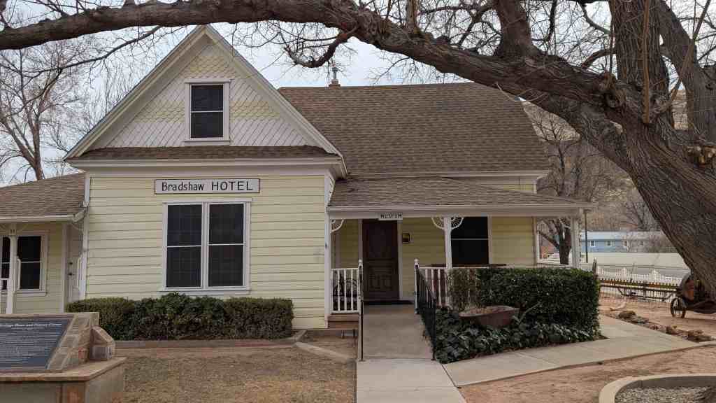
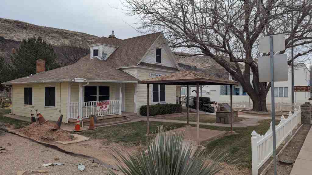
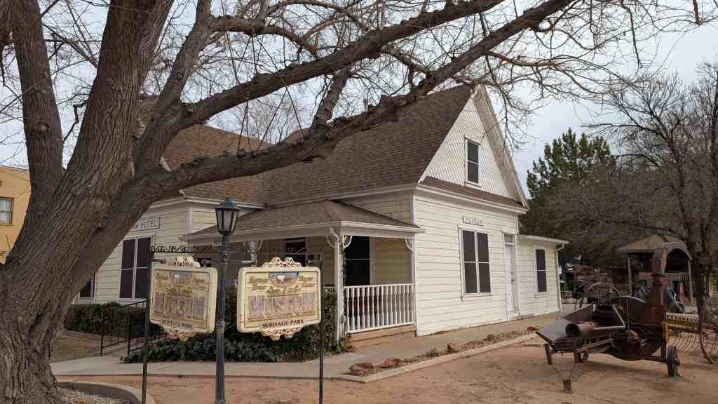
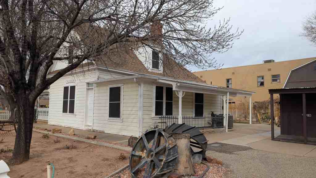
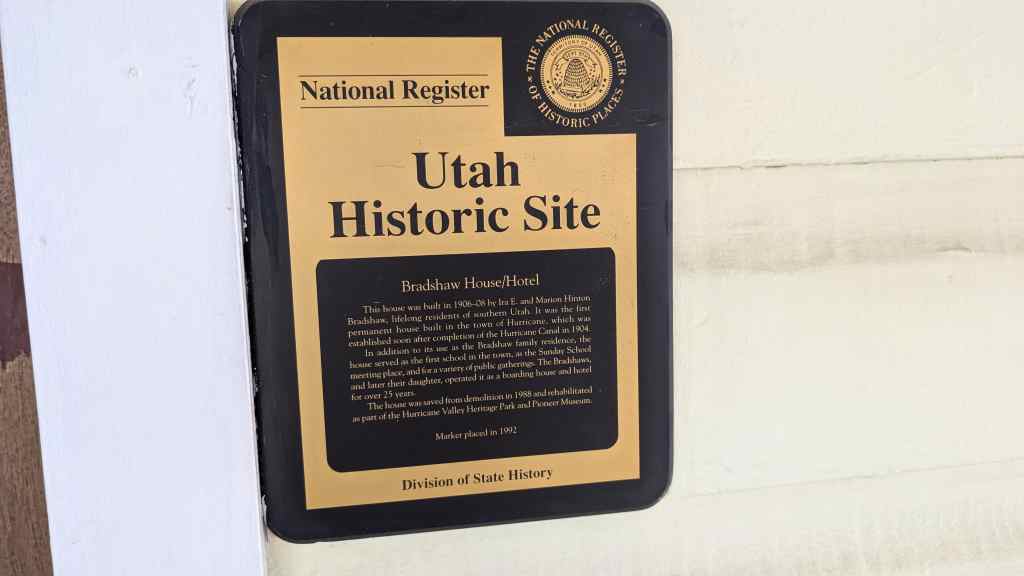
Built in 1906-08, the Bradshaw House/Hotel is significant for its role in the settlement and early community life of Hurricane, Utah. It was the first permanent house built in the town, which was established soon after the Hurricane Canal (National Register) was completed to bring water to this previously dry benchland. In addition to its use as the Bradshaw family residence, the house served as the first school in the town, as a place for Sunday school, and for a variety of other public gatherings. The Bradshaws also operated it as a boarding house and hotel, the first in the community. It was one of the few hotels in the town and one of the longest-lived, operating for over 25 years.
The Bradshaw House-Hotel is located at 85 South Main Street in Hurricane, Utah and was added to the National Historic Register (#91001443) on September 26, 1991. The text on this page is from the nomination form from when it was added to the register.
Ira E. and Marion Hinton Bradshaw started construction of this house in early 1906 and had it sufficiently completed by the end of the summer for the family to move in. According to family and local histories, it was the first permanent house built in the new community of Hurricane. As such it served a variety of community purposes since it was the largest building in town. The northwest room, though at first unfinished, served as the town’s first school, as a Sunday school room, and for other public gatherings. These activities were eventually shifted to other buildings as the town developed. These included a social hall (1908), a church (1907-08), and a school (1917).
Completion of the Hurricane Canal in 1904 opened up the Hurricane Bench for agriculture and instigated the formation of the town. Residents of neighboring communities first began constructing the canal in 1893. They continued under adverse conditions for nine years. By then only a few of the original canal stockholders still had faith to remain with the project. One of them was Ira Bradshaw, who served as president of the Hurricane Canal Company from 1901 to 1907. The group contacted the First Presidency of the Church of Jesus Christ of Latter-day Saints (Mormon Church) in Salt Lake City requesting assistance with their project. The church had directed the establishment of over 300 communities in Utah from 1847 to the late 1880s, so assisting with settlement efforts was not new. At this time, however, the church was no longer actively colonizing in Utah. The effort to build the canal and establish the town of Hurricane was a private venture. The church’s decision to invest $5,000 in the project demonstrates the leaders’ willingness to assist with community-building, though in a more business-like fashion than it had in the nineteenth century. Without the infusion of cash generated by the church’s purchase of stock, the company may not have completed the canal.
Settlement of the town of Hurricane began soon after the canal was completed. Stockholders drew lots to determine their parcels in the new townsite. The town was laid out in five-acre blocks divided into four lots. Twenty-acre farm sites south of town were divided in the same manner. Many of the early settlers built cellars or granaries that could serve temporarily as homes and later be used as auxiliary structures. Only one of those granaries is extant: the George H. and Annie C. Isom granary located at 274 W. 100 North, where it was moved in 1945.
Ira Bradshaw’s house is credited as the first permanent home in the town. Others were apparently built at approximately the same time. A Washington County News article from January 1908 noted that, “Lewis Campbell is finishing off the Ira Bradshaw house. It will soon be ready for the painter. Jesse Lemmon expects to have his house painted soon. Jesse Demill’s house is almost completed.” Though Bradshaw’s house was not completed until 1908, it was, according to numerous local sources, being used in an unfinished condition as early as the fall of 1906. Of the three houses mentioned in the article only the Bradshaw house remains standing.
Both Ira and Marion Bradshaw were lifelong residents of southern Utah. They were married in 1883 and had five children. They made their home in Virgin until moving to Hurricane after the canal was completed. Ira held a variety of jobs, including farmer, canal worker, and hotel operator. He served six years as president of the Hurricane Canal Company and twenty years as a member of the school board.
In addition to its community uses, the house also functioned as a hotel. Marion Bradshaw was an industrious homemaker and managed to accommodate traveling salesmen, known as “drummers,” and other travelers in the house. She also boarded teachers. From 1910 to 1923 the house became known as the Bradshaw Hotel. A c.1912 photograph shows the house, complete with a balustraded front porch and a “Bradshaw Hotel” sign over the front window. Thus it was the first hotel in the town of Hurricane. In 1917, The Hotel Monthly magazine gave a description of the clean rooms and sumptuous meals at the “little Bradshaw Hotel.” After Marion Bradshaw’s death in 1924, a daughter and son-in-law, “Mack” and Juanita Bradshaw Naegle, helped run the hotel and take care of the family still at home. Ira Bradshaw transferred title to the property to Juanita in 1929. Mack and Juanita decided to construct a new hotel just to the north. They operated that hotel only from 1930 until 1932. The economic decline brought on by the Depression forced them to close it down. They resumed taking boarders in the old home as before. Soon after Ira Bradshaw 1 s death in 1934, the loan company that held title to the property sold it, forcing the family to close down the hotel and move.
Other owners since 1942 were: the J. H. Ridings, the Golden Taylors, the Kenneth Gublers and Leah C. Adams and Miriam L. Cochran. The last two (who were joint owners) sold the property to Washington County in 1976. In June of 1989, Washington County leased the property to the City of Hurricane, who then leased it to the Hurricane Heritage Park Foundation in July of 1989. It is leased for a 25 year period, for a $100 per year lease with an option to renew. The foundation is in the process of the rehabilitating the hotel.
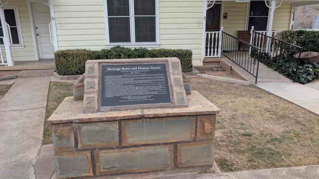
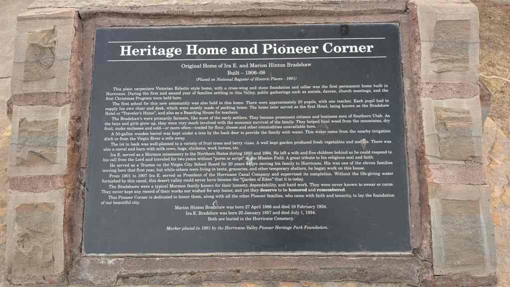
Heritage Home and Pioneer Corner Original Home of Ira E. and Marion Hinton Bradshaw Built 1906-08 (Placed on National Register of Historic Places – 1991)
This plain carpenters Victorian Eclectic style home, with a cross-wing and stone foundation and cellar was the first permanent home built in Hurricane. During the first and second year of families settling in this Valley, public gatherings such as socials, dances, church meetings, and the first Christmas Program were held here.
The first school for this new community was also held in this home. There were approximately 20 pupils, with one teacher. Each pupil had to supply his own chair and desk, which were mostly made of packing boxes. The home later served as the first Hotel, being known as the Bradshaw Hotel or “Traveler’s Home”, and also as a Boarding House for teachers.
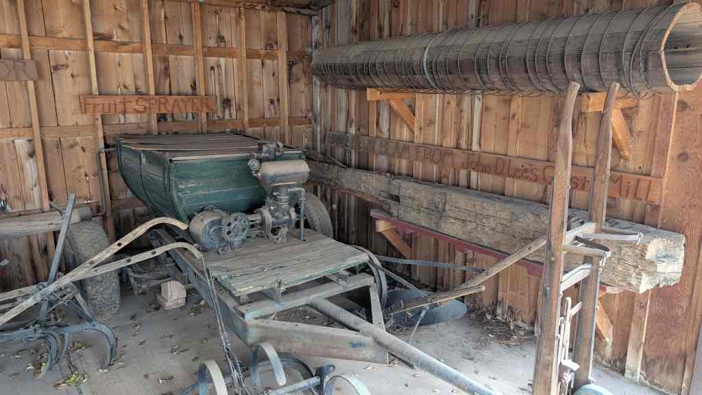
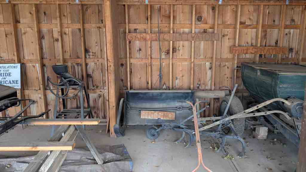
The Bradshaw’s were primarily farmers, like most of the early settlers. They became prominent citizens and business men of Southern Utah. As the boys and girls grew up, they were very much involved with the economic survival of the family. They helped haul wood from the mountains, dry fruit, make molasses and sold-or more often-traded for flour, cheese and other commodities unavailable here.
A 50-gallon wooden barrel was kept under a tree by the back door to provide the family with water. This water came from the nearby irrigation ditch or from the Virgin River a mile away.
The lot in back was well-planted to a variety of fruit trees and berry vines. A well kept garden produced fresh vegetables and melons. There was also a corral and barn with milk cows, hogs, chickens, work horses, etc.
Ira E. served as a Mormon missionary to the Northern States during 1893 and 1894. He left a wife and five children behind so he could respond to his call from the Lord and traveled for two years without “purse or script” in the Mission Field. A great tribute to his religious zeal and faith.
He served as a Trustee on the Virgin City School Board for 20 years before moving his family to Hurricane. His was one of the eleven families moving here that first year, but while others were living in tents, granaries, and other temporary shelters, he began work on this house.
From 1901 to 1907 Ira E. served as President of the Hurricane Canal Company and supervised its completion. Without the life-giving water furnished by this canal, this desert valley could never have become the “Garden of Eden” that it is today.
The Bradshaws were a typical Mormon family known for their honesty, dependability, and hard work. They were never known to swear or curse. They never kept any record of their works nor wished for any honor, and yet they deserve to be honored and remembered.
This Pioneer Corner is dedicated to honor them, along with all the other Pioneer families, who came with faith and tenacity, to lay the foundation of our beautiful city.
Marion Hinton Bradshaw was born 27 April 1866 and died 19 February 1924. Ira E. Bradshaw was born 25 January 1857 and died July 1, 1934. Both are buried in the Hurricane Cemetery. Marker placed in 1991 by the Hurricane Valley Pioneer Heritage Park Foundation.
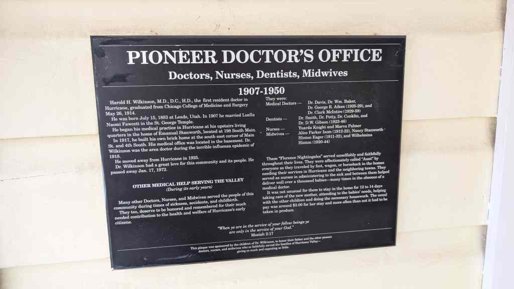
Harold H. Wilkinson, M.D., D.C., H.D., the first resident doctor in Hurricane, graduated from Chicago College of Medicine and Surgery May 26, 1914.
He was born July 15, 1883 at Leads, Utah. In 1907 he married Luella Naomi Fawcett in the St. George Temple.
He began his medical practice in Hurricane at his upstairs living quarters in the home of Emanual Stanworth, located at 198 South Main. In 1917, he built his own brick home at the south east corner of Main St. and 4th South. His medical office was located in the basement. Dr. Wilkinson was the area doctor during the terrible influenza epidemic of 1918.
He moved away from Hurricane in 1925.
Dr. Wilkinson had a great love for this community and its people. He passed away Jan. 17, 1972.
OTHER MEDICAL HELP SERVING THE VALLEY (During its early years)
Many other Doctors, Nurses, and Midwives served the people of this community during times of sickness, accidents, and childbirth.
They too, deserve to be honored and remembered for their much needed contribution to the health and welfare of Hurricane’s early citizens.
They were:
Medical Doctors
Dr. Davis, Dr. Wm. Baker,
Dr. George R. Aiken (1925-29),
Dr. Clark McIntire (1929-59)
Dentists
Dr. Smith,
Dr. Petty,
Dr. Conklin,
Dr. D.W. Gibson (1923-46)
Nurses
Yuarda Knight
Marva Palmer
Midwives
Alice Parker Isom (1912-22),
Nancy Stanworth Hinton Eager (1911-32),
Wilhelmina Hinton (1920-44)
These “Florence Nightingales” served unselfishly and faithfully throughout their lives. They were affectionately called “Aunt” by everyone as they traveled by foot, wagon, or horseback to the homes needing their services in Hurricane and the neighboring towns. They served as nurses in administering to the sick and between them helped deliver well over a thousand babies-many times in the absence of a medical doctor.
It was not unusual for them to stay in the home for 12 to 14 days taking care of the new mother, attending to the babies’ needs, helping with the other children and doing the necessary housework. The usual pay was around $3.00 for her stay and more often than not it had to be taken in produce.
“When ye are in the service of your fellow beings ye are only in the service of your God.” Mosiah 2:17
This plaque was sponsored by the children of Dr. Wilkinson, to honor their father and the other pioneer doctors, nurses, and midwives who so faithfully served the families of Hurricane Valley- giving so much and expecting so little,
Bradshaw House/Hotel
This house was built in 1906-08 by Ira E. and Marion Hinton Bradshaw, lifelong residents of southern Utah. It was the first permanent house built in the town of Hurricane, which was established soon after completion of the Hurricane Canal in 1904.
In addition to its use as the Bradshaw family residence, the house served as the first school in the town, as the Sunday School meeting place, and for a variety of public gatherings. The Bradshaws, and later their daughter, operated it as a boarding house and hotel for over 25 years.
The house was saved from demolition in 1988 and rehabilitated as part of the Hurricane Valley Heritage Park and Pioneer Museum.