• About JacobBarlow.com
  • Cemeteries in Utah
  • D.U.P. Markers
  • Doors
  • Exploring Utah Email List
  • Geocaching
  • Historic Marker Map
  • Links
  • Movie/TV Show Filming Locations
  • Oldest in Utah
  • Other Travels
  • Photos Then and Now
  • S.U.P. Markers
  • U.P.T.L.A. Markers
  • Utah Cities and Places.
  • Utah Homes for Sale
  • Utah Treasure Hunt

JacobBarlow.com

~ Exploring with Jacob Barlow

JacobBarlow.com

Tag Archives: SLSCR

SLC to SoCal – Fort Utah

03 Friday Nov 2017

Posted by Jacob Barlow in Uncategorized

≈ 2 Comments

Tags

Historic Markers, Provo, Provo River, SLSCR, utah, utah county

2017-09-23 14.27.28

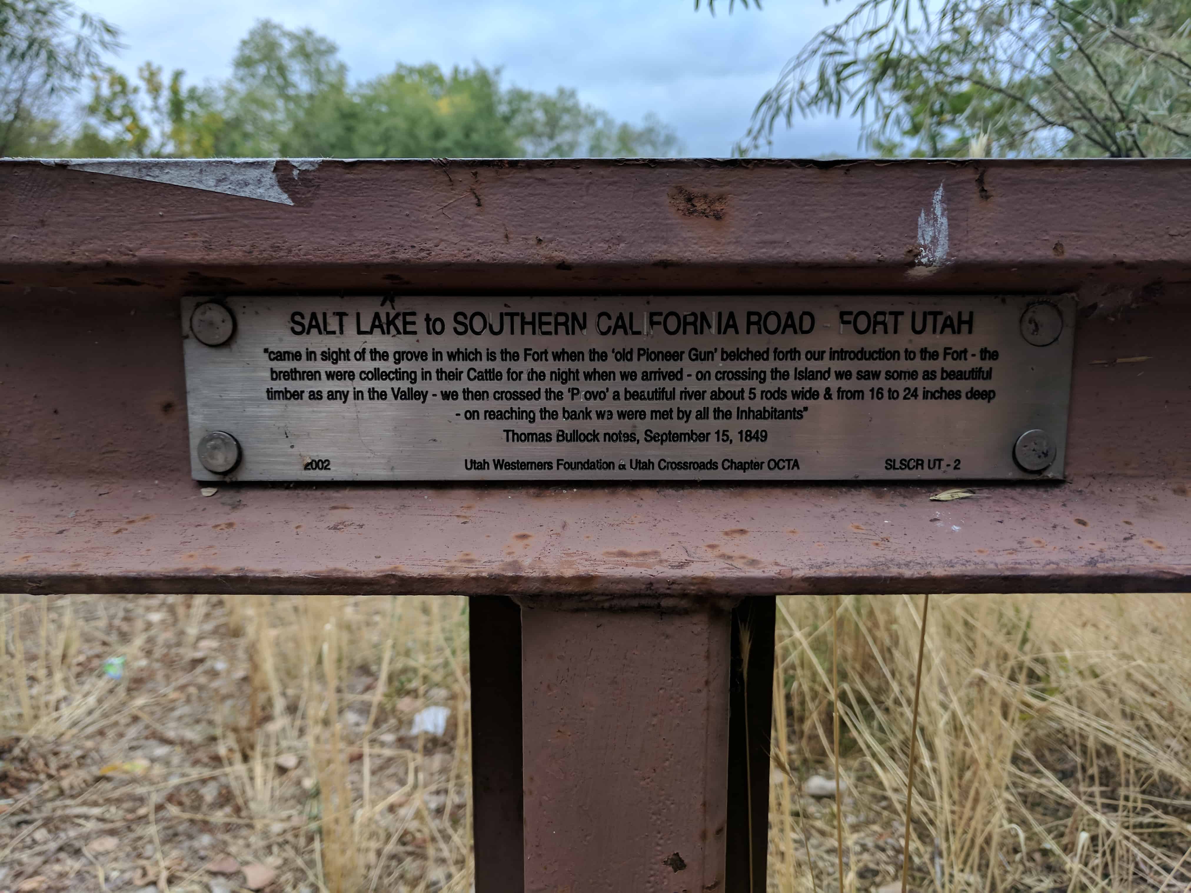
Salt Lake to Southern California Road – Fort Utah

“came in sight of the grove in which is the Fort when the ‘old Pioneer Gun’ belched forth our introduction to the Fort – the brethren were collecting in their Cattle for the night when we arrived – on crossing the Island we saw some as beautiful as any in the Valley – we then crossed the ‘Provo’ a beautiful river about 5 rods wide & from 16 to 24 inches deep – on reaching the bank we were met by all the Inhabitants.”

-Thomas Bullock notes, September 15, 1849

Related posts:

  • Fort Utah
  • Fort Utah DUP Marker
  • Fort Utah Park
  • Salt Lake to Southern California Road Historic Markers

2017-09-23 14.27.33

California Trail Markers

03 Friday Nov 2017

Posted by Jacob Barlow in Uncategorized

≈ 6 Comments

Tags

California Trail, Hastings Cutoff, SLSCR

The historic markers of the Salt Lake to Southern California Road series.

  • SLSCR UT-1 – Point of Mountain – N 40.45151 W 111.91419
  • SLSCR UT-2 – Fort Utah – N 40.23945 W 111.68921
  • SLSCR UT-3 – Peteetneet – N 40.04095 W 111.73217
  • SLSCR UT-7 – Cove Fort  – N 38.60133 W 112.58059
  • SLSCR BC-2 Burnett Cutoff – Muddy Water – N 41° 50.703 W 121° 18.606
  • SLSCR L-3 – Lassen Trail – Conical Rocks – N 41° 33.931 W 120° 26.445
  • SLSCR L-5 – Lassen Trail – Pit River Ford – N 41° 28.831 W 120° 32.525
  • SLSCR L-10 – Lassen Trail – Foot Wear – N 41° 23.998 W 120° 56.090
  • SLSCR L-11 – Lassen Trail – Pit River Canyon – N 41° 25.214 W 121° 00.356

The historic markers of the Hastings Cutoff series.

  • H JM UT 1 – Hastings Cutoff – James Mathers – Weber Canyon Devils Gate – N 41.13901 W 111.84821
  • HU-3.2 – Hastings Cutoff – The Hogsback – N 40.95391 W 111.54986
  • HU-3A – Hastings Cutoff – Broad Hollow – N 40.93511 W 111.56748
  • HU-3B – Hastings Cutoff – East Canyon Creek – N 40.91732 W 111.57993
  • HU-3C – Hastings Cutoff – East Canyon Creek 4th Crossing – N 40.89724 W 111.58785
  • HU-3D – Hastings Cutoff – Large Spring Camp – N 40.81945 W 111.58308
  • HU-3E – Hastings Cutoff – Big Mountain Pass – N 40.82793 W 111.65445
  • HU-5 – Hastings Cutoff – Utah Outlet (Jordan River) N 40.71209 W 111.92345
  • HU-5A – Hastings Cutoff / Central Overland Trail – Deadman’s Cave – N 40.72184 W 112.15550
  • HU-10A – Hastings Cutoff – Horseshoe Springs – N 40.61374 W 112.70805
  • HU-11 – Hastings Cutoff – Horseshoe Springs – N 40.61391 W 112.70767
  • HU-16 – Hastings Cutoff – West Side of Hastings Pass

The historic markers of the Central Overland Trail series.

  • COTU-1 – Washington Square – N 40.76035 W 111.88786
  • COTU-2 – Jordan River Bridge – N 40.77167 W 111.92581
  • COTU-2A – Hastings Cutoff / Central Overland Trail – Deadman’s Cave – N 40.72184 W 112.15550
  • CUTU-5 – Central Overland Trail – Rush Valley – N 40.45176 W 112.36270
  • COTNU-2 – Five Mile Pass – N 40.23161 W 112.17858
  • COTNU-3 – Lookout Pass – N 40.11479 W 112.56595
  • COTNU-4A – Central Overland Trail – Skull Valley – N 40.08335 W 112.76367
  • COTNU-7 – Central Overland Trail – Simpson Springs – N 40.03936 W 112.78722
  • COTNU-7A – Old Riverbed Junction – N 39.96976 W 112.88786
  • COTNU-8 – Dugway Pass – N 39.85216 W 113.08584
  • COTNU-8A – Black Rock Hills Southern Route – N 39.87267 W 113.16283
  • COTNU-10A – Fish Springs Mountain – N 39.89865 W 113.44693
  • COTNU-12 – Boyd Station – N 39.84375 W 113.55373
  • COTNU-13 – Willow Springs [Callao] – N 39.90027 W 113.71421
  • COTNU-14 – Deep Creek Summit – N 40.09983 W 113.87909

The historic markers of the Hensley / Salt Lake Cutoff series.

  • HSLC UT 1 – Hensley / Salt Lake Cutoff – Warm Springs – N 40.79020 W 111.90054
  • HSLC UT 3-A – Hensley / Salt Lake Cutoff – Heavy Sand – N 41.18265 W 112.00960

The historic markers of the Jedediah Smith’s Trail series.

  • JSTU-1 – Great Salt Lake – N 40.74664 W 112.18543

Trails West has a lot of info on these markers.

My page on the California Trail is here.

SLC to SoCal – Cove Fort

03 Wednesday May 2017

Posted by Jacob Barlow in Uncategorized

≈ 2 Comments

Tags

Cove Fort, Historic Buildings, Historic Markers, Millard County, SLSCR, utah

2017-03-26 14.27.50

Salt Lake to Southern California Road – Cove Fort

“16th Passed over some beautiful rich bottoms covered with green grass which is uncommon at this season of the year on this route.  Passed over a high divide into a beautiful round valley [Cove Fort].  I shot the largest hare in this valley I have ever seen.  23 miles today.”  – Addison Pratt, Oct. 16, 1849.

Here is the list of “Salt Lake to Southern California Road” markers I have come across.

2017-03-26 14.28.02

Follow Jacob

Follow Jacob

Blog Stats

  • 2,036,287 hits

Social and Other Links

BarlowLinks.com

Recent Posts

  • Pioneer Hay Barn, Manger, and Corral
  • Grain Reaper
  • Early Pioneer Granary and Home
  • Dixie Sorghum (Molasses) Mill
  • This is the Place State Park

Archives


Loading Comments...