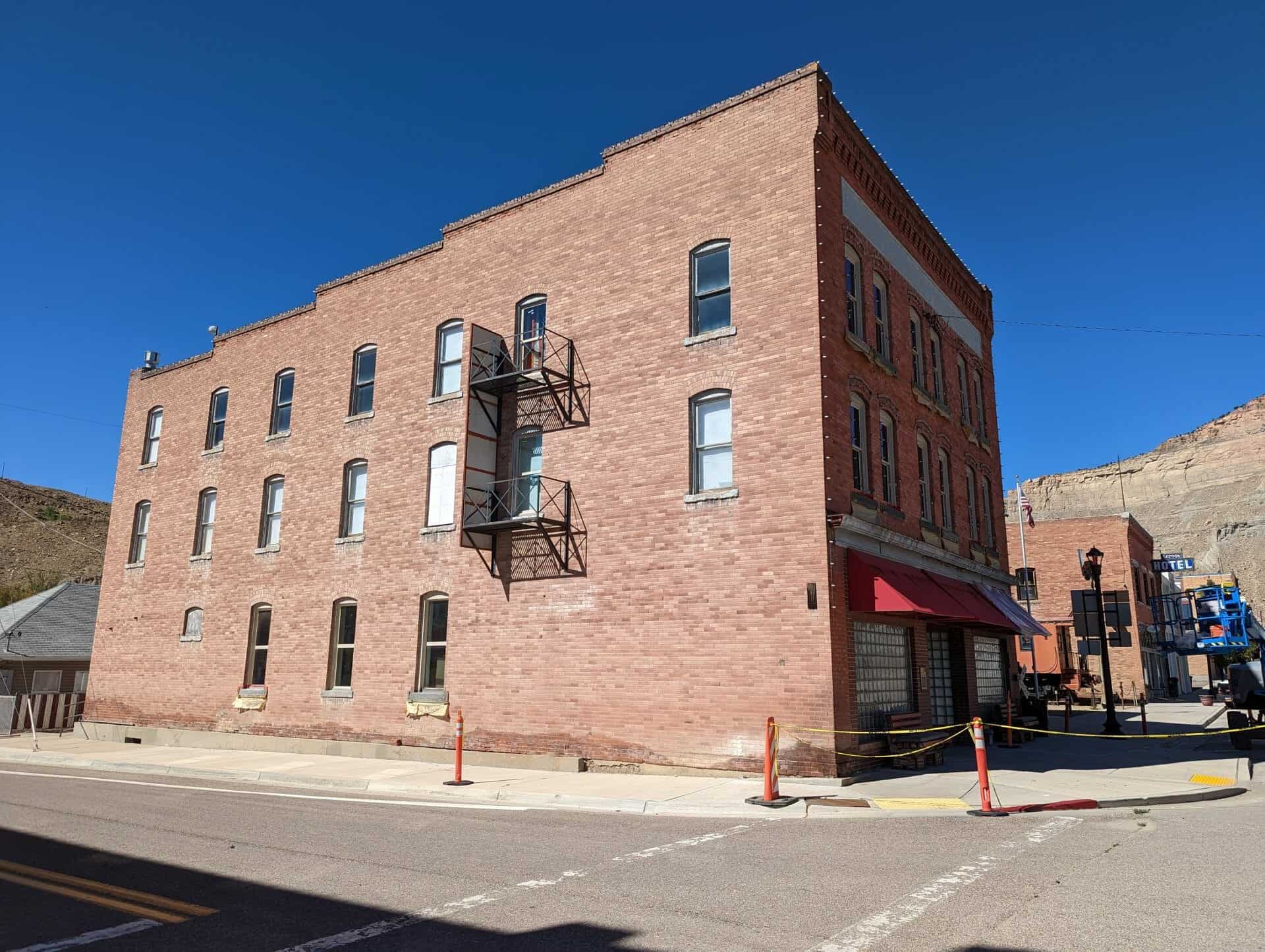
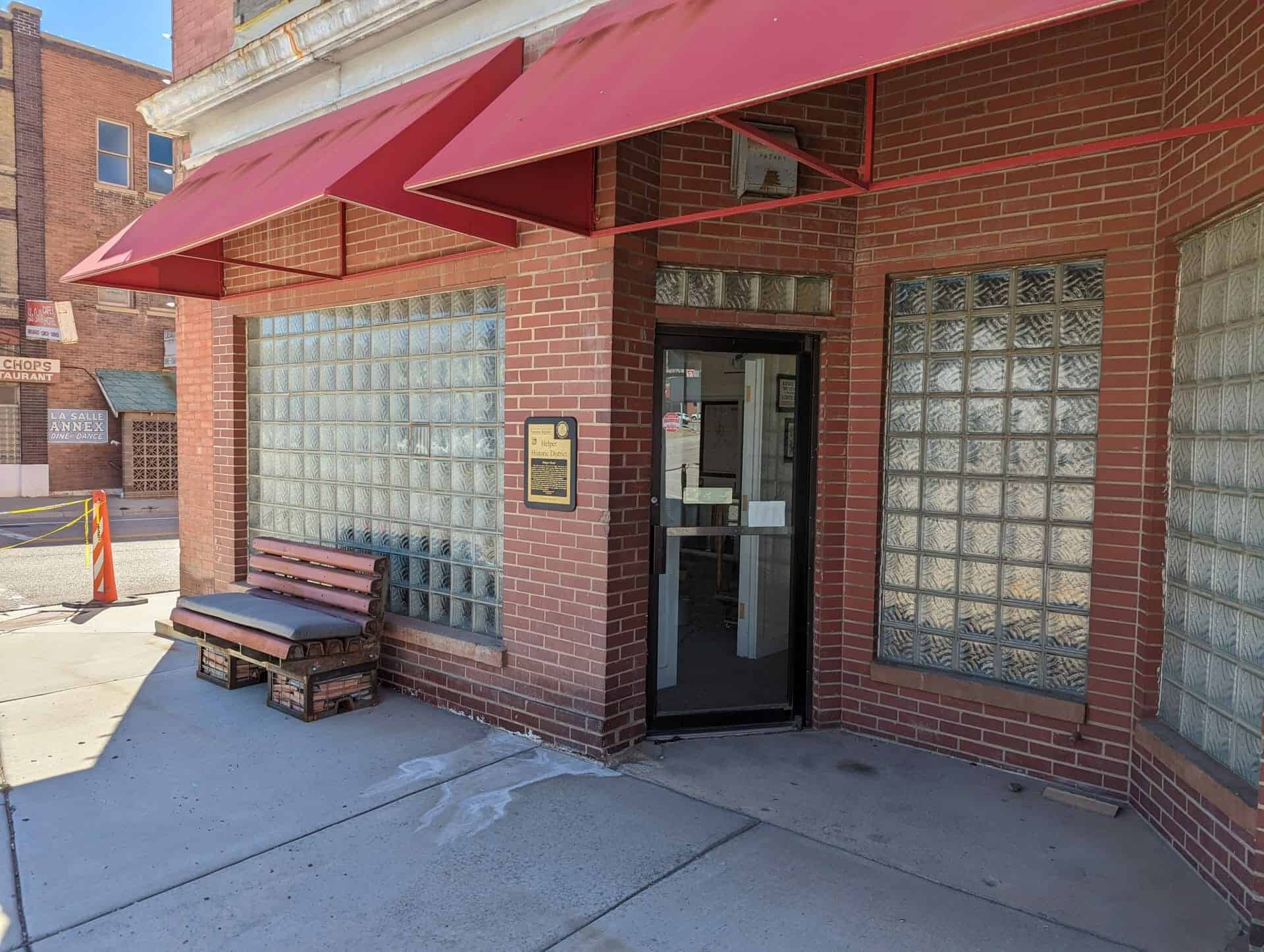
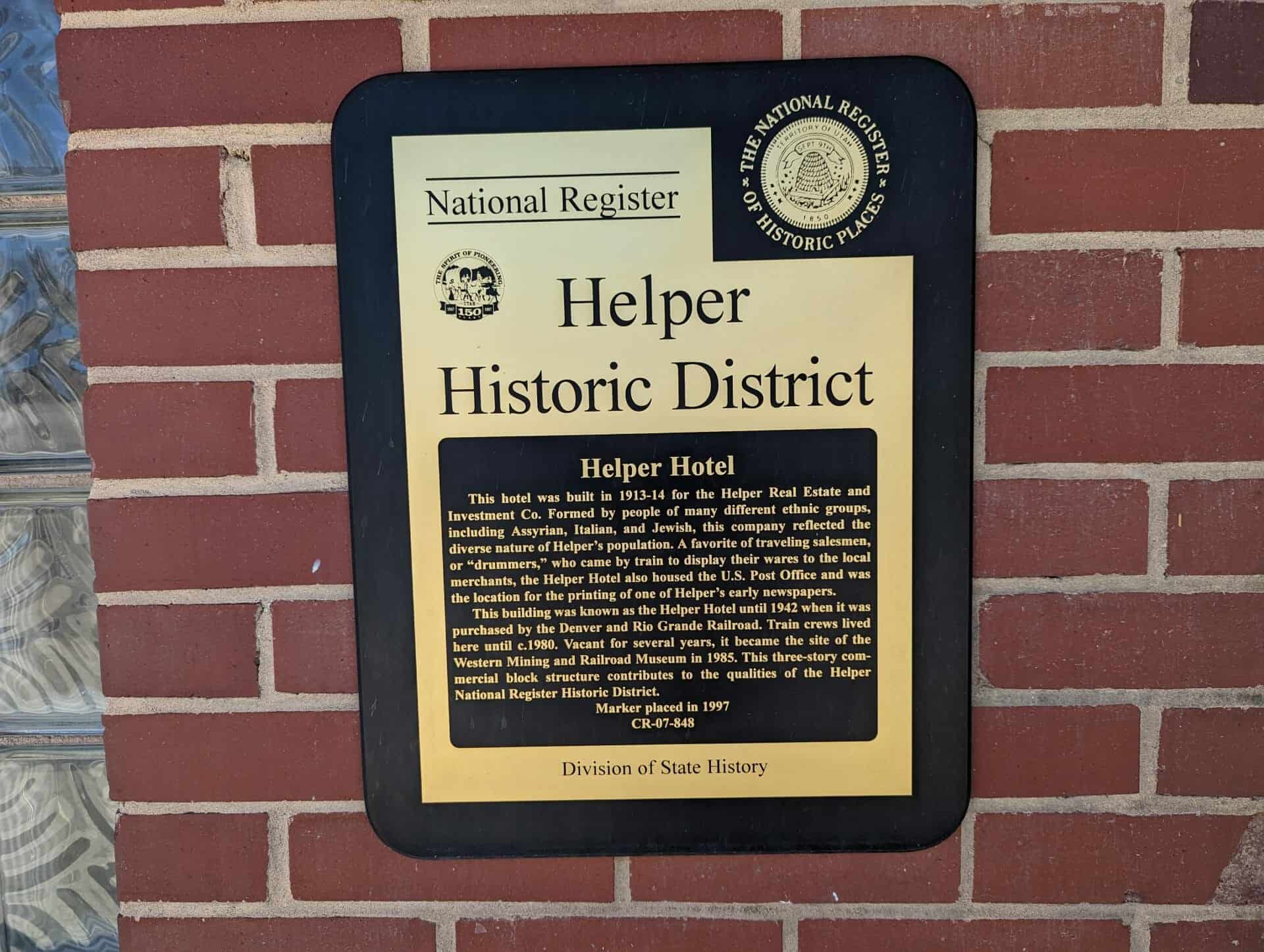
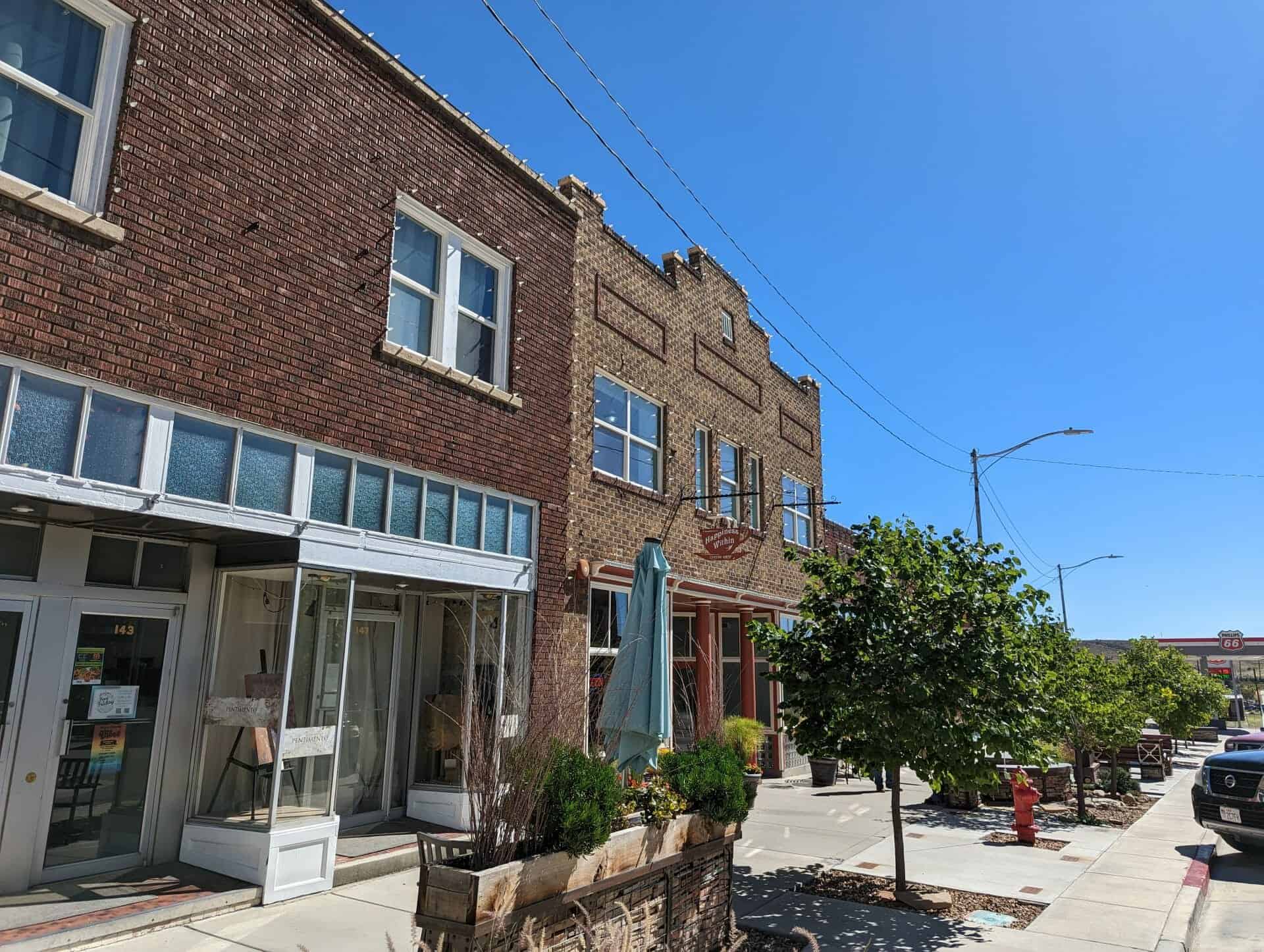
This hotel was built in 1913-14 for the Helper Real Estate and Investment Co. Formed by people of many different ethnic groups, including Assyrian, Italian, and Jewish, this company reflected the diverse nature of Helper’s population. A favorite of traveling salesmen, or “drummers,” who came by train to display their wares to the local merchants, the Helper Hotel also housed the U.S. Post Office and was the location for the printing of one of Helper’s early newspapers.
This building was known as the Helper Hotel until 1942 when it was purchased by the Denver and Rio Grande Railroad. Train crews lived here until c.1980. Vacant for several years, it became the site of the Western Mining and Railroad Museum in 1985. This three-story commercial block structure contributes to the qualities of the Helper National Register Historic District.
The Helper Hotel is part of the The Helper Museum at 294 South Main Street in Helper, Utah
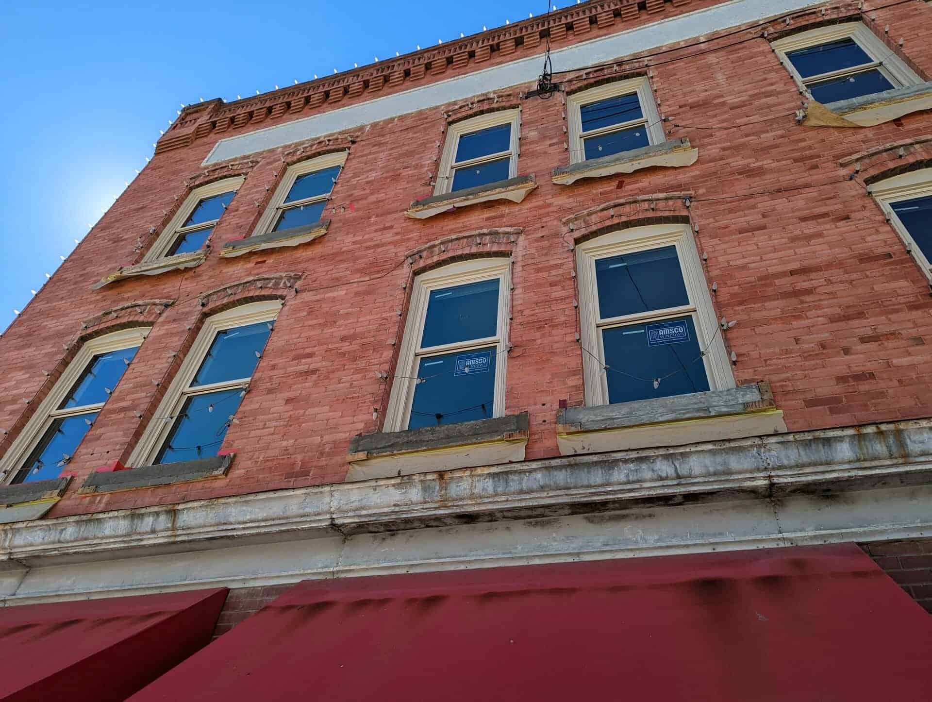
Three story brick commercial building originally owned by the Helper Real Estate and Investment Company of which Joseph Barboglio was president. Originally known as the Hotel Helper, the business was managed by Joseph Litizzette, eldest son of August Sr. The Hotel was a favorite of traveling salesmen or “drummers” who came in on the trains. The LHS of the downstairs was a display area for the drummers to show their “wares” to the local merchants. The RHS housed the U.S. Post Office until it was moved to its present location in 1937. The D.&R.G.W.R.R. purchased the building in 1942 to replace the older Y.M.C.A. which was razed. Except for glass blocks in the front windows, the building appears unaltered.
This two-story brick commercial building was constructed in 1929. The varied shades of tan bricks are unusual in the historic district. In the early 1930s, the right side of the building was occupied by the “Smart Shop” owned by N. A. Neilson, and the second story housed professional offices. Thorit and Janet Hatch operated the Helper Insurance and Loan Company here for many years.
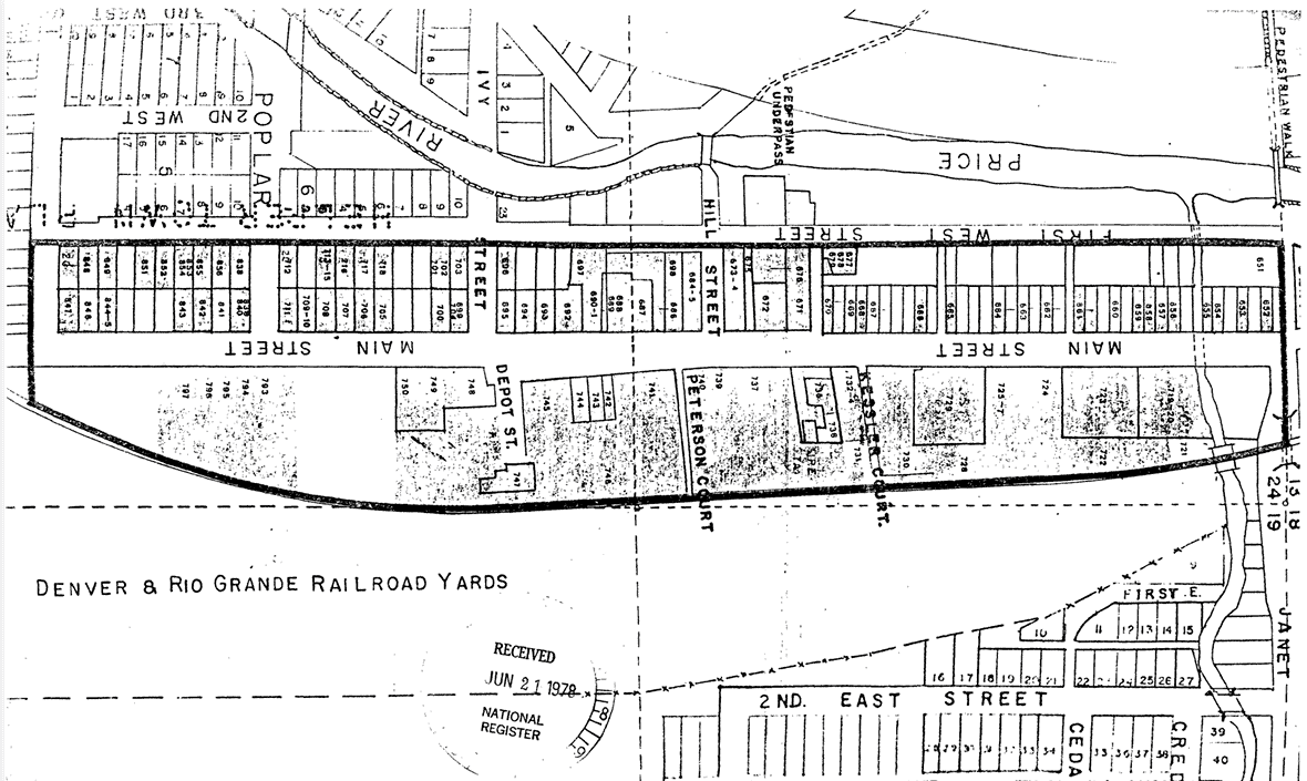
The Helper commercial district is located within the present city limits of Helper, Utah. The District is entirely within the E 1/2 of the NE 1/4 of Section 24, Township 13 South, Range 9E Salt Lake City Standard Meridian. The District is bounded on the north by Janet Street, on the west by First West Street, on the South by Locust Street and on the east by the Denver and Rio Grande Western (D&RGW) railyards. The size of the district is somewhat less than 40 acres and includes, but is not limited to, the entire extent of Pratt’s and Mead’s Survey Platts.
The existing boundaries were selected because of their tight nature, delineating the main Helper commercial district, as well as access points to that area. The inclusion of residences was determined by both their presence on Main Street or their adjacent location to the street and within business district, other residences were excluded and may be part of a future multiple resource nomination.
Janet Street is the northern boundary, and with its underpass (to the east) represents the effective beginning of Helper’s Main Street. On the west is First West Street which contains some residences, but included major rear access ways to the commercial buildings on Main Street. Locust Street boarders the district on the south, representing the end of the main commercial area. The eastern boundary follows the Rio Grande Western railway yards, which formed a vital part of Helper’s commercial life.
The Helper commercial district consists of a total of 110 of which 98 sites have been judged to be potentially contributory to the historic character of the area. A wide variety of both residential and commercial structures, arrayed along both sides of Main street in a north-south manner, comprise the district.
The Helper Commercial District was listed on the National Register of Historic Places (#79002491) on July 24, 1979.
The Helper Commercial District is representative of several areas of significance in the history and cultural development of Carbon County and the surrounding region. Helper’s development as a town was primarily the result of the Denver and Rio Grande Railroad and the mining of the surrounding bituminous coal fields. During the early twentieth century, Helper became the major service center for both the railroad and the regional coal fields. Helper also served as a social center for the hundreds of immigrants of various nationalities who came to Carbon County to work in the mines. Many of these immigrants and their children later became residents and business leaders in the community, thus contributing to Helper’s distinctive ethnic heritage which is still evident today.
The residential buildings are generally one story and are fairly modest in appearance. Several styles and building materials were utilized, including; hand hewn stone, wood frame, stucco, and several types of brick. The commercial buildings also exhibit a wide degree of variability, although they are generally consistent in scale, with almost all buildings being one to two stories in height. The predominate building material was red brick, although hand hewn stone stucco, wood frame, and other types of brick were also utilized.
Comparison of the present appearance of the district with early Sanborn maps and historic photos indicates that the area still retains much of its historic character. Prior to 1927 the area east of Main Street was dominated by Denver and Rio Grande Western (D&RGW) railroad company houses, but after that time, the area began to acquire the predominately commercial appearance it retains today. The modifications of the residential buildings have been fairly minor and have generally consisted of “modern” siding materials and additions, and modification of the porches. The commercial seen facade modifications, many of which are the installation of the enclosure or buildings have often minor and reversable.
A description of each contributory building along with its capsule history is given below. The buildings are listed by their Utah Historical Society site inventory number.
ARCHITECTURE
Although not necessarily representative of historically important “high” architectural styles, the Helper Commercial District is neverthe= less architecturally significant. The district represents an interesting evolution of early twentieth century building types, and is also reflective of the cultural heritage of the Carbon County region.
The earliest commercial buildings were of the small wood frame type which were typical of “boom towns.” However, a series of disastrous fires, especially in May of 1919 destroyed all but one of these “boom town” buildings. The one remaining wooden commercial building (#677) is therefore particularly significant because it represents the first stage in the districts architectural sequence.
As the commercial enterprises became more established, the hand hewn native stone structures, built by immigrant Italian stone masons, became more predominant. The outstanding example of this phase is the Lowenstein Mercantile (#690), a building that was a very important element in the town’s early street scape.
During the later twenties the district experienced a substantial building boom which was reflective of the relative prosperity being experienced by the coal industry. Most of the commercial buildings in the district date from this period and are constructed in fairly standard commercial styles.
The two most important public buildings in the district, the City Hall and the Civic Auditorium are also architecturally significant. The City Hall (#735), designed by architect W.E. Ware of Salt Lake City in 1927, is a good example of a late Classical Revival style building. The Civic Auditorium (#723) was constructed in the International Style in 1936 by Scott and Welch of Salt Lake City.
The residential structures in the district also represent a variety of building types. There are numerous examples of “company town” style houses of which sites 658 and 796 are outstanding examples. It is possible that the location and size of the company houses was reflective of the occupational and social status of the occupant. Another building type of special interest is the stone house, of which site 718 is the best example in the district. Like the stone commercial buildings, these houses were hand crafted by immigrant Italian stone masons and may have special research potential. A comparative study, similar to Glassies Virginia Folk housing research, 1 could be instituted to examine what transformations occurred when the Italian masons adapted their craft to the needs of the American environment.
COMMERCE
As the service center for the Carbon County coal fields and the D&RGW railroad, Helper was an important focus of commercial activities, with a wide range of goods and services available. Grocery, furniture, variety, cleaning, clothing, and general mercantile stores as well as a bank were all present from the early periods of the town’s history, and were often identified with or catered to a specific ethnic group.
Of the numerous sites in the district which once housed food stores (sites 665, 668, 672, 687, 688, 693, 741), two are of special signifiance. The Helper Bakery, Meat, and Grocery (665) was continuously operated from 1913 until c. 1940 by Louis Fossat, a first generation Italian immigrant who catered to the surrounding coal camps by delivery truck as well as to the local population. The Helper Fish Market (668) was operated by the Amanos, a first generation (Issei) Japanese family, from 1922 until 1954. Like the Fossat store, the Fish Market was associated with a specific ethnic group, but also served the general community as well.
Several sites in the district housed furniture and general mercantile businesses (671, 686, 690, 739, and 741). Of these, 686 and 690 are especially significant because of their association with the Mutual Mercantile Company. The Mutual Company has been in continuous operation since 1924 and is therefore the oldest retail business in Helper. It is also of interest because it represented an unusual partnership between an Italian, J.P. Rolando and a Slovene, John Skerl , who still helps operate the business today.
Until recently, the Helper State Bank (687) was the only banking institution in Helper, and controlled much of the commercial activity of the area. The bank’s founder, Joseph Barboglio, was a first generation Northern Italian immigrant, as were about half of the banks original stockholders. The bank therefore represents the high level of involvement of Northern Italian businessmen in the commercial activities of Helper. Helper State Bank has been in continuous operation in the present location since 1914, making it the oldest surviving commercial entity of any type in Helper today.
The Helper Commercial District therefore, provided the wide range of goods and services typically required in a mining region. In addition, the multi-ethnic character of the population also contributed to the formation of a very distinctive commercial district, unlike any other found in the state.
EDUCATION
Two sites in the district deserve significance from their involvement in the educational process in Carbon County. The basement of Harry Eda’s variety store (669) was utilized as a summer school for the Japanese children in Helper and the surrounding coal camps. Although instruction was given in Japanese, the school was probably also an important factor in the adjustment of the children to their American environment. The basement of the Railroad Chapel (746) was also utilized for educational purposes. Classes for students of the general community were held in this building until the construction of the Helper Central School in c. 1920.
POLITICS / GOVERNMENT
Three sites in the district as well as several landscape features are significant because of their assocation with both the local and federal government.
The Helper Civic Auditorium (#723) is important in the local governmental process as a meeting place for community and political party meetings. The auditorium is also of significance because it was a Public Works Administration (PWA) project (PWD Docket Utah # 1059 R.S.), one of many federal programs designed to help ease the unemployment problems associated with the Depression. Although not specifically a depression relief project, the construction of the United States Post Office (#729) in 1937 also probably provided. needed economic stimulus for the community. The Helper City Hall (#735) has been the focus of the town’s political process since its construction in 1927. All of the functions of city government as well as the volunteer fire department are centered at this building and will continue to be so in the forseeable future.
Much of the landscape of the district is of significance because of its modification by Works Progress Administration (WPA) projects which were designed to promote resource conservation and unemployment relief during the depression. There are numerous stone retaining walls and other features in the district (such as in front of site 724) which date from this period. The channel of the Price River was also straightened and diverted at this time. As a result of this project, the channel of the Price River was diverted toward the west, away from the commercial district. In place of the river channel in the northern half of the district, First West Street (the western boundary of the present district) was built upon fill dirt which was hauled in, thus resulting in better flood control; improved access to the rest of the buildings, and a major modification of the landscape.
RELIGION
Three buildings in the district derive significance from the importance of religion in the history of Helper. Although it has suffered major modifications, the Railroad Chapel is still reflective of the religious heritage of the region. Non-Denominational services as well as a few Catholic and masses were held in this building since its construction in 1899.
Because the original Catholic Church has been destroyed, the two buildings (719, 720) which serve the parish today are of greater significance than their relatively late construction dates (1945) would indicate. Catholicism was the major religion of the Helper region, and was especially important to the Italian, Slovenian, and Croatian immigrants. The Church served as a means of maintaining one’s ethnic identity,2 but later probably also served as an integrative mechanism for the various groups within the community. These two buildings therefore represent the continuation of the important religious and social functions of the Catholic Church.
SOCIAL/HUMANITARIAN
In addition to the buildings listed under politics/government, one building in the district is of significance because it represents an aspect of the government’s efforts to alleviate the social problems associated with the Depression. The Ricci Market building (666) served as an emergency shelter for transients passing through Helper, providing food and an overnight rest at no expense. Local informants indicate that there were many “hobos” who came through town on freight trains, using Helper as a “stopping-over” point.
TRANSPORTATION
The theme of transportation, especially the Denver and Rio Grande Railroad, is one of the most significant in Helper’s history. The town derives its name from the “helper” locomotives which were added to the freight trains to assist the ascent of Soldier Summit enroute to Provo. The existence of Helper as a commercial entity can be traced back to the completion of the Denver-Salt Lake D&RGW route in 1883.
It was the railroad which made possible the continued development of Helper’s economy. The exploitation of Carbon County’s extensive coal mines was dependent upon the railroad for transportation to in-; dustrial centers elsewhere in Utah and the United States. The railroad itself was a major consumer of the region’s coal and also served the commercial district by supplying wholesale goods and new residents, many of whom were foreign immigrants. Helper was and still is, a “turn around” point between Grand Junction Colorado and Salt Lake City Utah. This meant that many railroad workers were either permanently stationed in Helper or stayed overnight in the town before returning to either Salt Lake or Grand Junction. The high degree of ~ interdependence between Carbon County and D&RG is demonstrated by the fact that the rail company devoted-its entire May, 1926 trade magazine to the promotion of Carbon County.
So as would be expected a large number of buildings in the district derive their significance from their association with the railroad industry. At one time, the D&RG owned all of the land in the district east of Main Street, and still retains title to much of this area. Sites 724, 725, 727, 723, 733, and 793-797 were probably all railroad, company houses, and represent only a remnant of the many residences which were originally located in the eastern half of the district. Also reflective of the company’s concern for the welfare of its employees is7 the Railroad Chapel (746) which was constructed at company expense.
The involvement of the railroad in the commercial activities of the community is represented by the express freight depot (722), the receiving point for much of the town’s perishable foodstuffs and other high priority freight. Two buildings in the district also represent the ongoing maintenance activities of the railroad. Site 728 served as a shelter for inspectors who checked the mechanical condition of trains stopped in the Helper railyards, and site 749 ..i. was utilized as a large maintenance garage. The present passenger depot (747), although of fairly recent construction (c.1940) is significant because it represents a continuation of a very important facet of Helper’s commercial life. The depot presently serves the Rio Grande Zephyrs, one of the very few remaining privately owned passenger trains in the country.
Automotive transportation has also had an impact upon the/history of Helper. Auto stage lines such as the Salt Lake and Eastern Utah (site 689) provided needed transportation, especially between the train depot and the surrounding communities which had no regularly scheduled rail passenger service. During the twenties the automobile came into widespread use, affecting the appearance and commerce of the town. During this time the streets were paved and Helper became more accessible to the surrounding camps. Numerous businesses were established to cater to the new industry (sites 689, 705, 842, 843, 846, and 749). In particular, the Midland Service Station (846) is remembered by many long-time residents as a special landmark that marked the southern edge of the commercial area.
RECREATION
In addition to providing the goods and services normally required in any area, Helper also provided a distinctive range of services which could best be characterized as “recreational.” The multi-ethnic character of the population and the predominance of single young men, many of whom were immigrants, combined to create a unique clientele for such businesses as theaters, coffee houses, restaurants, pool halls, and rooming houses.
Of the five sites in the district which once housed theaters (666,673, 685, 690, 696), two are of special interest. The Strand Theater (685) reportedly showed silent Japanese movies in the basement and hosted traveling Kabuki theater groups. The Liberty Theater (696) was the first silent movie theater in Helper, and also served as an important social center. Public dances and Greek weddings were often held here as well as sporting events such as wrestling and boxing matches.
For the Greek immigrant the coffee house was an especially important recreational center. The coffee house not only allowed them to smoke, gamble, drink Turkish coffee, and converse with friends, but also provided a way to maintain and reaffirm their ethnic identity and ties with the home!and.4 At least two coffee houses were located in buildings which are still extant in the district. These were the Zappion Coffee House (700) and the Athens Coffee House (706). Both of these buildings had window signs in Greek and English.
The single miners and railroad men who worked in the Helper region depended heavily upon the town for their recreational activities. As evidenced by the capsule histories, there were a great many buildings in the district which contained saloons, pool halls, and restaurants, most of which catered, in some’degree, to the single miner and railroader. Even during the prohibition period many of the pool halls and other businesses undoubtedly provided bootleg liquor.
As can be seen in the capsule histories, almost every multi-story building in the district had a rooming house or hotel in the upper stories. Some of these businesses such as the LaSalle Hotel (840) catered especially to railroad men, while others, such as the Hotel Helper (711) were patronized more by traveling salesmen or “drummers.” A large portion of the rooming houses, however, catered primarily to single men who came to Helper from the surrounding camps for a few days of “R&R”. Several of these houses (such as 669) were associated with prostitution. The “going rate” was described as $1.00 a night for a room and an additional $2.00 for the services of a prostitute. Prostitution has always been an element of Helper’s “public reputation” and has perhaps been over exaggerated. A former city attorney described the prostitutes as “independent contractors” and doubts there was any organized crime involvement. He also estimated the number of working prostitutes as probably not much over twenty at any given time.
IMMIGRATION
The most important unifying theme in the history of the Helper Commercial District is that of immigration. Carbon County has been called “Utah’s Ell is Island” because of the large number of immigrants who came to the area to work in the coal fields and on the railroads. During the first half of this century an estimated 40 to 45 different nationalities or ethnic groups could be found in Carbon County. 6 In both the 1910 and 1920 censuses Carbon was the only county in the state having greater than 25% of its population classified as “foreign-born white.” Shown below are the populations of some of the more important ethnic groups in the county:
Greek
Italian
South Slav & Austrian
Japanese
1910 – 797
1910 – 798
1910 – 544
1910 – 197
1920 – 869
1920 – 1,215
1920 – 315
1920 – 516
1930 – 533
1930 – 935
1930 – 397
1930 – 384
As the service and social center for the region, Helper became the most ethnically diversified community in the county. Several historians have noted this fact and Stipanovich in particular states that Helper had one of the three largest South Slav communities in the state. 8 This large immigrant population not only provided a vital labor source, but also created unique demands for goods and services and provided many of the prominent business and social leaders of the area. The significance of this cultural heritage in the history of the Helper Commercial District can be demonstrated by examining the relationship between the above four ethnic groups and several of the more important buildings.
The Italians were numerically the most important ethnic group in Helper and were the first to settle in the area in significant numbers. After the failure of the 1903-04 coal strike, a dispute which had been labeled an “Italian strike,” many of the Italian miners began farming along the Price River or started businesses in Helper rather than return to the mines. 9 A notable exception to this pattern was August Litizzette Sr., a Northern Italian immigrant who, by 1900, had made enough money working in the mines to have started a business growing and selling produce in Helper and surrounding coal camps. The Litizzettes became one of the most prominent families in Helper, at one time owning thirteen of the sites in the district (652-659, 661, 664, 693, 696, and 711). Two of these, the Aval on Hotel (693) and the Hotal Helper (711) were among the largest and most important buildings in the district.
Another Northern Italian of special note was Joseph Barboglio, founder of Helper State Sank (687), the only financial institution in Helper during most of its history. Barboglio was originally a miner in Castle Gate and became involved in the 1903-04 strike as a union official. After extensive traveling and business dealings, he returned to Helper to build the Tika Tavern building in 1907 (where site 691 is now located) and^establish Helper State Bank in 1910. Barboglio also served as Helper’s last town president and first city mayor from 1912 through 1915. The two Barboglio residences graphically represent the family’s growing prosperity and prestige. The first of these, a fairly modest stone home (847) was constructed in 1910, possibly by Joseph himself. The second home (848) is a very impressive red brick residence constructed next to the original home in 1927. The building is in immaculate condition and is considered by most Helper residents to be the outstanding historic home still extant in the town.
Although Northern Italians were the predominant ethnic group in the economic activities of the town, several Southern Italians also attained positions of prominence. One of these was John Eaquinta, who built the LaSalle block (840) in 1922 after operating sheep and goat ranches in the Spring Canyon area for several years.
Like the Italians, the Greeks also came to Carbon County in large numbers to work in the coal mines, most of them expecting to remain only a short time. However, for a variety of reasons, many Greeks stayed in Carbon County, and by the end of World War I, many were established in business enterprises. As a result of the 1922 coal strike, a struggle especially associated with the Greeks, man$ more men left the labor ranks to go into business for themselves. In Helper, some of the more important Greeks included Gus Tsangaris, owner of the Toggery clothing store (686), and George Zeese, president of Helper Securities from 1927 until 1945. Helper Securities controlled a significant portion of Helper’s commercial district, including sites 695, 739-741, and 745.
South Slavs were in Carbon County as railroad workers as early as the 1890’s. They later became involved in coal mining and participated wtth the Italians in the strike of 1903-04. Following World War I, there was a large influx of South Slavs into Carbon County from “the old country” and from other coal fields, especially those in Southern Colorado. The Slavic community in Helper was fairly substantial and included several prominent entrepreneurs such as Rudy Rebel, co-owner of the Castle Rock Mercantile (687, 693) and John Skerl, co-owner of the Mutual Mercantile (686,690).
Of the four groups being examined, the Japanese have probably had the least impact upon the cultural development of Carbon County. Although very few persons of Japanese ancestry remain in the area, there were over 500 Issei or first generation Japanese in Carbon County during the twenties, most of whom worked as laborers, especially on the railroad, and expected to return home within a short time. Most of the Japanese apparently either returned home or moved to other areas of the country. However a few, such as Harry Eda, operator of a popular variety store (669), and Kay and Masa Amano, owners of the Helper Fish Market (668) remained in Helper to become successful business operators and respected members of the community.
All four of these ethnic groups, as well as many others, have contributed aspects of their cultural heritages to the history of Helper, and these contributions are represented in the built environment of the town’s commercial district.