• About JacobBarlow.com
  • Cemeteries in Utah
  • D.U.P. Markers
  • Doors
  • Exploring Utah Email List
  • Geocaching
  • Historic Marker Map
  • Links
  • Movie/TV Show Filming Locations
  • Oldest in Utah
  • Other Travels
  • Photos Then and Now
  • S.U.P. Markers
  • U.P.T.L.A. Markers
  • Utah Cities and Places.
  • Utah Homes for Sale
  • Utah Treasure Hunt

JacobBarlow.com

~ Exploring with Jacob Barlow

JacobBarlow.com

Tag Archives: Navigation Beacons

Tooele County Airmail Arrows and Beacons

18 Saturday Nov 2023

Posted by Jacob Barlow in Uncategorized

≈ Leave a comment

Tags

Historic Markers, Navigation Arrows, Navigation Beacons, Stockton, SUP, Tooele County, utah

Tooele County Airmail Arrows and Beacons

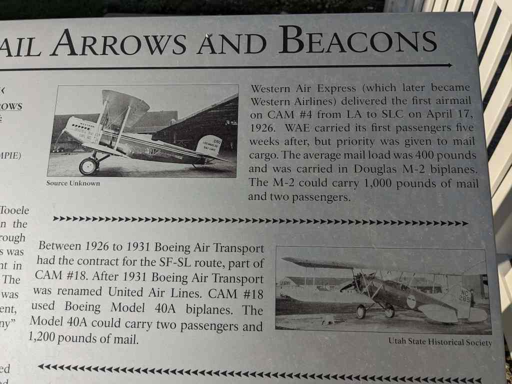
Western Air Express (which later became Western Airlines) delivered the first airmail on CAM #4 from LA to SLC on April 17, 1926. WAE carried its first passengers five weeks after, but priority was given to mail
cargo. The average mail load was 400 pounds and was carried in Douglas M-2 biplanes. The M-2 could carry 1,000 pounds of mail and two passengers.

Between 1926 to 1931 Boeing Air Transport had the contract for the SF-SL route, part of CAM #18. After 1931 Boeing Air Transport was renamed United Air Lines. CAM #18 used Boeing Model 40A biplanes. The Model 40A could carry two passengers and 1,200 pounds of mail.

The route was not lighted and mail could only be delivered by daylight until July 1, 1924 when the first nighttime airmail flights started. The lighted airway was completed in 1927. The airway contained lighted Airway Beacons. These beacons were spaced approximately 10 miles apart (closer in the mountains and farther away in the plains) and had 24 inch, million candle-power lights mounted on 51 foot towers. These towers were centered on an airmail arrow with a 10 x 14 ft engine generator shed oriented to the western/ southern beacon and an arrowhead oriented to the next eastern/northern beacon. The concrete arrow and shed were painted chrome-yellow (the shade of school buses).


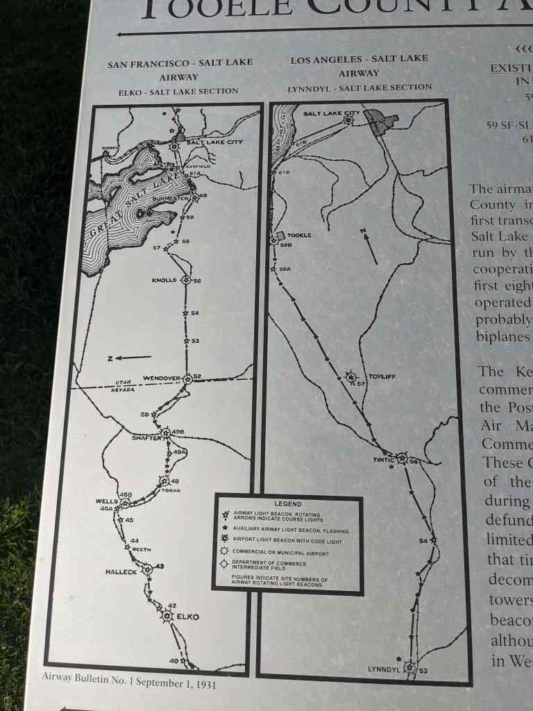
EXISTING AIRMAIL ARROWS IN TOOELE COUNTY:

  • 59 LA-SL STOCKTON
  • 57 SF-SL LOW
  • 59 SF-SL POVERTY POINT (TIMPIE)
  • 61A SF-SL LAKE POINT

The airmail initially went through Tooele County in September 1920 when the first transcontinental route went through Salt Lake and through to Reno. This was run by the Post Office Department in cooperation with the US Army. The first eight years of airmail delivery was operated by the US Government, probably using Curtiss “JN-4 “Jenny” biplanes and De Havill and DH-4s.”

The Kelly Act of 1925 “encouraged commercial aviation and authorized the Postmaster General to contract for Air Mail Service”. This resulted in Commercial Air Mail (CAM) service. These CAMS ran from 1925. While most of these beacons were discontinued during the Depression and the program defunded, various beacons operated in limited capabilities into the 1940s. At that time the Department of Commerce decommissioned and disassembled the towers for their steel. The last airway beacon was officially shut down in 1973, although there still are beacons operating in Western Montana.

The text above is from Sons of Utah Pioneers historic marker #243, see other markers in the series here:

  • S.U.P. Markers

This is located in a little roadside park at the corner of Connor Avenue and Silver Avenue in Stockton, Utah along with other historic markers. Those located here are:

  • Central Overland Trail – Rush Valley
  • First Electric Light
  • Stockton Historic Marker
  • Tooele County Airmail Arrows and Beacons

The Transcontinental Airway System

15 Sunday Mar 2020

Posted by Jacob Barlow in Uncategorized

≈ Leave a comment

Tags

Concrete Arrows, Navigation Beacons

The Transcontinental Airway System was a navigational aid system built in the 1920s and 1930s.

These beacons allowed for day and night navigation across the country, there were 284 beacons built to guide the airmail with some of them using concrete arrows to point the way to the next beacon.

Someone who’s done much more work thanI have so far has their list here.

The sites I’ve documented are linked below:

Contract Air Mail Route #4 Los Angeles-Salt Lake

  • 36 LA-SL Motoqua
  • 37 LA-SL Hebron
  • 37A LA-SL St. George
  • 37A LA-SL Bloomington Overlook
  • 37B LA-SL Shinob Kibe
  • 38 LA-SL Quail Creek
  • 40A LA-SL Black Ridge
  • 44 LA-SL Milford
  • 44 LA-SL Picacho Peak
  • 49 LA-SL Borden
  • 50 LA-SL Clear Lake
  • 50 LA-SL Sunstone Knoll
  • 59 LA-SL Stockton
  • 60 LA-SL Tickville Springs

Contract Air Mail Route #5 Elko-Pasco / Salt Lake-Pasco / Salt Lake-Pendleton Airway

  • 2 SL-P Antelope Island N.
  • 4 SL-P Indian Cove
  • 6 SL-P Rozel Point
  • 7 SL-P Locomotive Springs

Contract Air Mail Route #18 San Francisco-Salt Lake / Salt Lake-Omaha Airway

  • 55 SF-SL Barro
  • 18_57 SF-SL Low
  • 18_59 SF-SL Poverty Point
  • 18_61A SF-SL Lake Point
  • 1A SL-O Fort Douglas / Big Beacon / Wire Mt.
  • SL-O Great Western Trail
  • SL-O Big Dutch Hollow
  • 4 SL-O Upton
  • SL-O Red Hole S

Contract Air Mail Route #26 Salt Lake-Great Falls

  • 26 SL-GF Farmington
  • 5B SL-GF Brigham

Los Angeles-Denver Airway

  • 45 LA-D Bryce Canyon CAA
  • Hanksville
  • Canyonlands

Unknown Airway / Airport

  • Michael AFB
  • Bolinder Tooele Valley
  • Carbon County (PUC) / Buck Davis Field
  • Green River Municipal (RVR)
  • Jean Nevada
  • Kanab Municipal (KNB)
  • Logan-Cache Airport
  • Richfield Municipal (RIF)
  • South Valley Regional Airport
  • Spanish Fork Springville

Other interesting info:

  • Arrows Across America
  • The Forgotten Giant Arrows that Guide you Across America

Follow Jacob

Follow Jacob

Blog Stats

  • 2,043,742 hits

Social and Other Links

BarlowLinks.com

Recent Posts

  • Jane Elizabeth Manning
  • Green Flake
  • Hark Wales & Oscar Smith
  • Threshing Machine
  • Spencer and Helen Isom “Home”

Archives


Loading Comments...