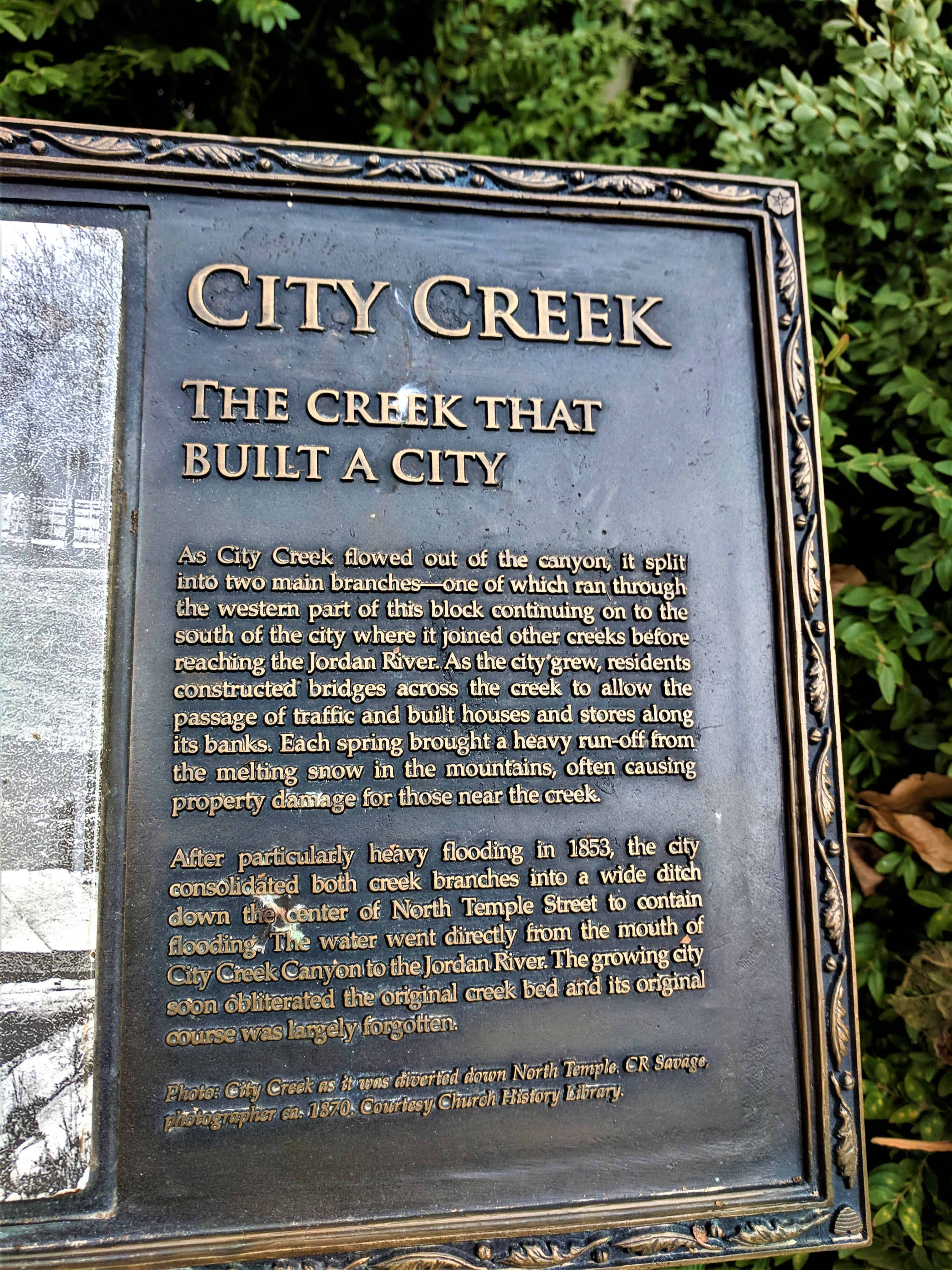
• About JacobBarlow.com
  • Best Mapping Site
  • D.U.P. Markers
  • Doors
  • External and Referral Links
  • Geocaching
  • Historic Marker Map
  • Movie/TV Show Filming Locations
  • Oldest in Utah
  • Other Travels
  • S.U.P. Markers
  • Utah Cities and Places.
  • Utah Treasure Hunt

JacobBarlow.com

~ Exploring with Jacob Barlow

JacobBarlow.com

Tag Archives: City Creek

City Creek

18 Tuesday Sep 2018

Posted by Jacob Barlow in Uncategorized

≈ Leave a comment

Tags

City Creek, Salt Lake City, Salt Lake County, utah

2017-12-02 15.12.27

City Creek

The creek that built a city

As City Creek flowed out of the canyon, it split into two main branches – one of which ran through the western part of this block continuing on to the south of the city where it joined other creeks before reaching the Jordan River.  As the city grew, residents constructed bridges across the creek to allow the passage of traffic and built houses and stores along its banks.  Each spring brought a heavy run-off from the melting snow in the mountains, often causing property damage for those near the creek.

After particularly heavy flooding in 1853, the city consolidated both creek branches into a wide ditch down the center of North Temple Street to contain flooding.  The water went directly from the mouth of City Creek Canyon to the Jordan River.  The growing city soon obliterated the original creek bed and its original course was largely forgotten.

2017-12-02 15.12.34

2017-12-02 15.12.39

2017-12-02 15.12.42

2018-12-15 12.31.282018-12-15 12.49.332018-12-15 12.56.052018-12-15 12.56.23

Richmond Fort

05 Tuesday Nov 2013

Posted by Jacob Barlow in Uncategorized

≈ 1 Comment

Tags

Brower Springs, Cache County, City Creek, Forts, Richmond, utah

A D.U.P. Marker in Richmond, Utah.

In July 1859 under the leadership of John Bair (Interpreter and Guide), sixteen families settled here. They built log cabins and dugouts between City Creek and Brower Springs. The following spring, other families arrived and a permanent fort was built for protection against Indians. The Fort consisted of two rows of houses running east and west, facing each other, with corrals and sheds for livestock back of the homes. This monument, built in honor of the Pioneers of 1859 and 1860, marks the southwest corner of the fort which ran 3000 feet east by 465 feet north.

(Other markers placed by the Daughters of Utah Pioneers are listed at: JacobBarlow.com/dup)

ImageImage

Follow Jacob

Follow Jacob

Social and Other Links

BarlowLinks.com

Blog Stats

  • 307,900 hits

Recent Posts

  • Utah State Capitol Dome
  • Emmeline B. Wells
  • Statue of Massassoit
  • Farr’s Fort
  • 212 E 500 S

Archives