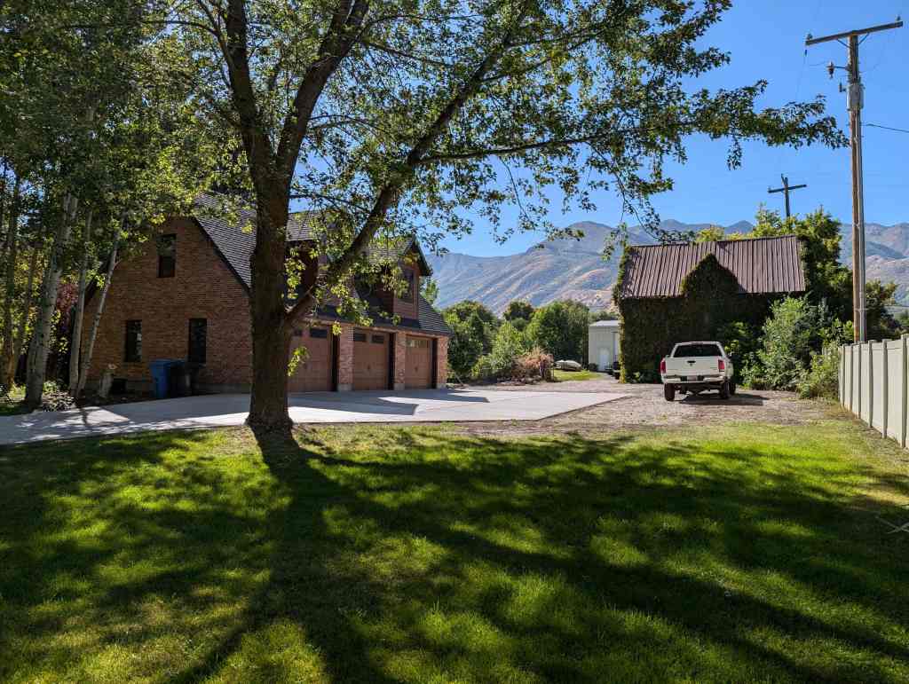
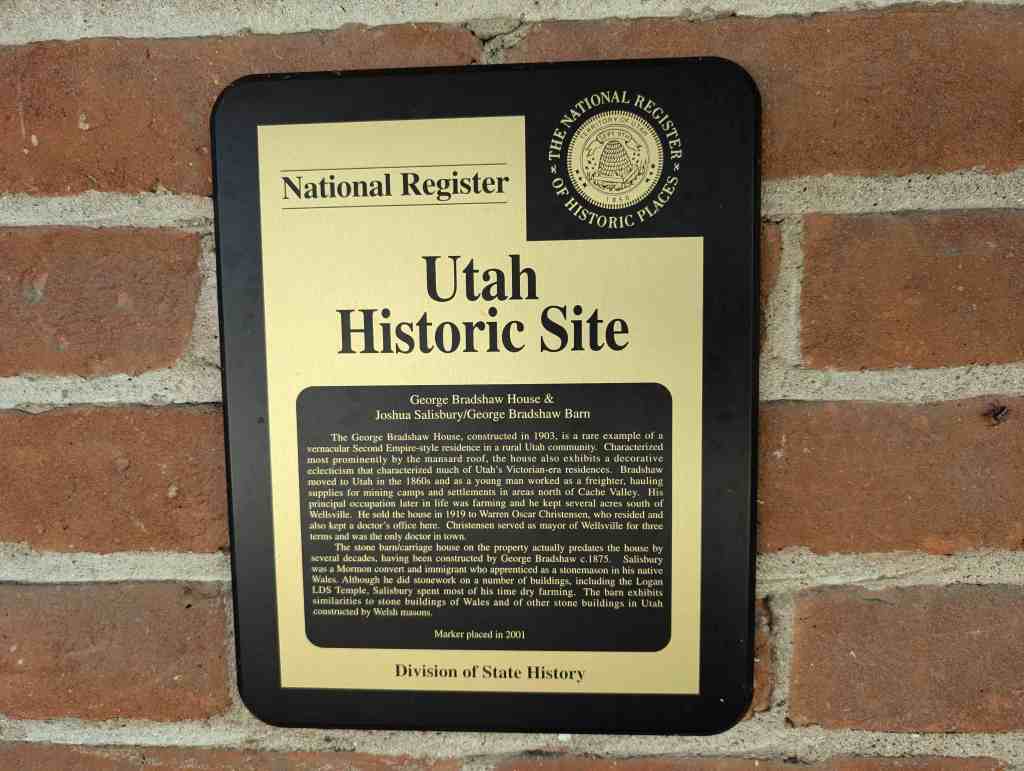
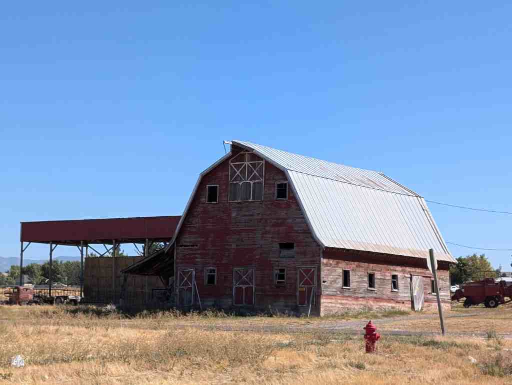
George Bradshaw House & Joshua Salisbury/George Bradshaw Barn
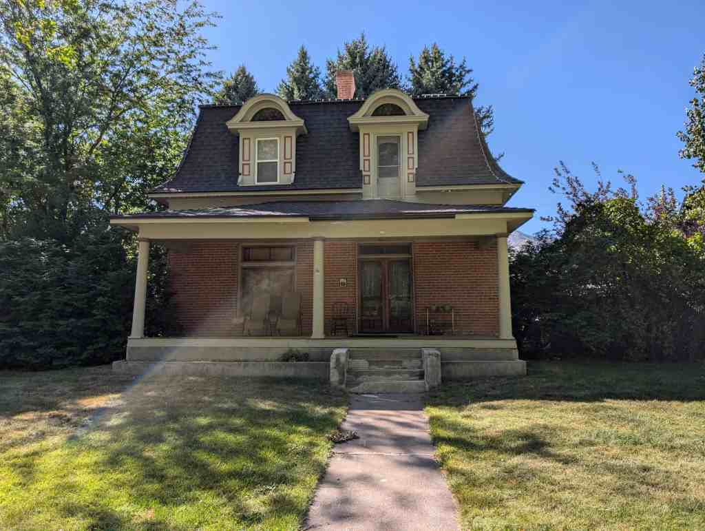
The George Bradshaw House, constructed in 1903, is a rare example of a vernacular Second Empire-style residence in a rural Utah community. Characterized most prominently by the mansard roof, the house also exhibits a decorative eclecticism that characterized much of Utah’s Victorian-era residences. Bradshaw moved to Utah in the 1860s and as a young man worked as a freighter, hauling supplies for mining camps and settlements in areas north of Cache Valley. His principal occupation later in life was farming and he kept several acres south of Wellsville. He sold the house in 1919 to Warren Oscar Christensen, who resided and also kept a doctor’s office here. Christensen served as mayor of Wellsville for three terms and was the only doctor in town.
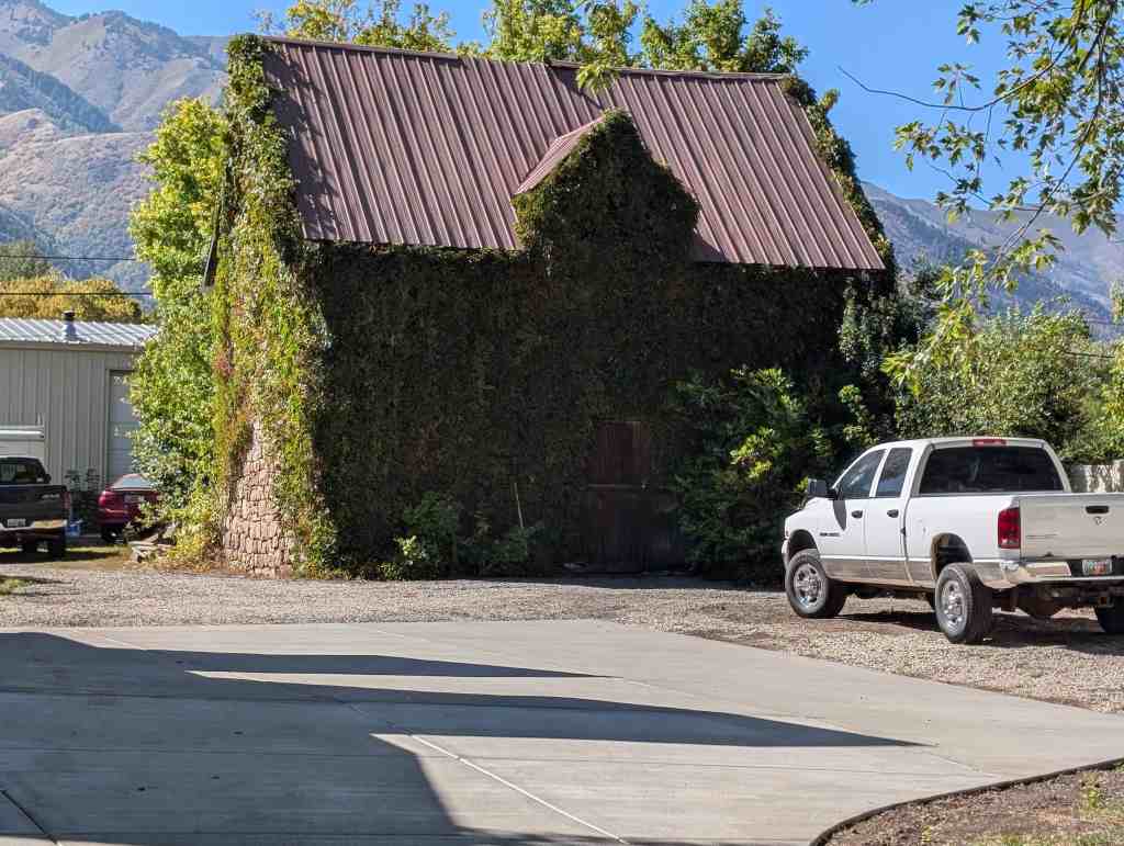
The stone barn/carriage house on the property actually predates the house by several decades, having been constructed by George Bradshaw c.1875. Salisbury was a Mormon convert and immigrant who apprenticed as a stonemason in his native Wales. Although he did stonework on a number of buildings, including the Logan LDS Temple, Salisbury spent most of his time dry farming. The barn exhibits similarities to stone buildings of Wales and of other stone buildings in Utah constructed by Welsh masons.
The Howell-Theurer home, built in 1869, is historically significant for a number of reasons. It was the home of Joseph Howell, an early settler of Cache Valley, who later became a very successful businessman and politician. He served seven consecutive terms as the Utah representative to the U.S. Congress.
The structure itself if a two story, five opening I-form house. Made from locally quarried stone, and ornamented in a restrained style. It is a good example of the vernacular house type, influenced by the Federal and Greek Revivial styles, built during the Mormon pioneer period of Utah’s history.
The Howell-Theurer House is located at 30 South 100 East in Wellsville, Utah and was added to the National Register of Historic Places (#79002490) on October 18, 1979.
Joseph Howell was born on February 17, 1857 in Honeyville to William Morgan and Martha Howell. Mrs. Howell was first married to a Mr. Howell in Wales. He died of cholera in the W.S. before moving out west. Mrs. Howell met William Morgan on her trip to the Utah Territory. He was the captain of their company. They were married after they arrived in Salt Lake by Brigham Young in 1855. Mr. Morgan began farming near Brigham City, and Joseph helped with the various tasks associated with the farm. “Reared amidst the most humble surroundings, his parents, friends, and neighbors never realized that the barefooted suntanned youth herding cows in the Box Elder hills was destined to become one of Utahs most capable and successful businessmen, an empire builder, and a representative of his fellow citizens in the largest and most distinguished peoples forum in the world-the United States Congress.”
There were difficulties in the marriage and Martha Howell and Mr. Morgan separated. In 1863, when Joseph was six years old his mother moved the family to Wellsville. It is not known exactly when the family moved into the stone house at 30 South 100 East, but Martha Howell was given the Townsite Deed for the property on September 16, 1872. She was quite wealthy in her own right from her fathers coal mining success, and was referred to as the elegant “Widow Howell”. Joseph Howell spent a portion of his childhood in this large home. After finishing public school he attended the University of Utah and the University of Deseret.
Mr. Howell spent; a few years after graduation as a school teacher, and established an enviable record in this regard. In 1878 Martha Howell deeded the stone home to Joseph Howell. He married Bishop William Maughan’s daughter Mary ( born August 12, 1856] and the couple lived for seven years with Martha Howell in the stone home. Joseph Howell became the manager of the Wellsville Mercantile Co-op. His powers and capabilities were recognized by Bishop William H. Maughan, who chose him as his counselor. In 1883, at the age of twenty five he was elected mayor of Wellsville. His wage was $50.00 a year.
The winter of 1885 was extremely severe. The task of fetching water from the outdoor well was durdensome for Mary Howell, who had four children at the time (She was to have ten total, five sons and five daughters). The family moved that winter to a wood frame house built by John Stoaddard, that had piped in water. The Howell’s retained ownerhsip of the stone home until 1905.
From 1886-1892 Mr. Howell served as member of the Territorial Legislature. He also served one term, from 1896-1900, in the Utah Senate. “Throughout all these activities he was the same commanding figure, wise in council, cool-headed keen and conservative in judgement, just and charitable, winning the respect and esteem of both friends and opponents alike.
The Howell family moved to Logan where, Mr. Howell became a business tycoon. He became a senior member of the Howell-Carbon Co., and the founder of the Howell Clothing Store. In ]909 he and David Eccles of Logan formed the Promontory-Curlew Land Co.. The feasibility of dry farming had just been discovered and several Cache Valley farmers were having great success. Eccles and Howell bought a half million acres in Box Elder, Cassia, and Oneida counties in Utah and Idaho. They offered grazing land, irrigated sites, and dry farm land for sale. By 1916 half of the land had already been sold to home seekers. It turned out to be a very profitable investment for both men. The new city formed as a result of this population influx was named Howell, Utah, in honor of Joseph Howell.
In the 1370’s and ,1880’s there was a tfreat deal of controversy in Utah concerning the question of polygamy and the separation of church and state. As the gentiles emerged as a significant body they demanded that polygamy be outlawed^ that the church must give up political activity through the Peoples Party, and that the church must cease directing the cooperative economic life for its community and open the doors to free competition. In 1890 the church terminated polygamy, and in 1891 disbanded the People Party. 1892 was the election year. To encourage the Saints to vote Republican, church leaders themselves took up the Republican standard. Joseph Howell, an active Mormon, was nominated U.S. Congressional candidate at the Republican State Convention in Ogden. He was selected over the non-Mormon incumbent George Sutherland, who many considered to be Utah’s greatest statesman and jurist. Riding on this strong anti-gentile sentiment, caused in part by the aforementioned events, Mr. Howell defeated the Democratic candidate William King by 6000 votes. This was the beginning of a fourteen year stint (1903-1917) as U.S. Congressman for Mr. Howell. He served seven successive terms, ever on the alert to promote Western interests. “While in Congress he may not of been frequently prominent upon the floor, but he was most active in committee work-shaping the policies of government. He had been instrumental in securing pensions for Indian War Veterans. Mr. Howell was also the senior Republican member of the Committee on Mines and Mining, and a member of the Committee of Agriculture.
Mr. Howell’s deep interest in the intellectual progress of the state was evidenced by his service as a member of the Board of Regents of the University of Utah and the Board of Trustees of Brigham Young University.
Mr. Howell returned to Logan after his distinguished career as a public servant He died suddenly at home due to a brain hemorrhage on July 18, 1918, at the age of sixty-one.
In 1915 Herman and Julia Theurer bought the stone home. Mr. Theurer opened a general merchandise store called the Golden Rule next to the home. The Theurer f s took exceptionally good care of the home, making many improvements on both the structure and the grounds. They lived in the house for forty-one years.
In summary, the life of Joseph Howell is the story of a self made man rising to prominence. He was a man of great energy and intellect. He achieved fame and recognition for his deeds from a state and national audience. His funeral drew “distinguished visitors from Salt Lake , Ogden, and elsewhere…and filled the tabernacle with a congregation of conference size.5” regardless of the accolades, Mr. Howell did not gorget his humble beginnings. He was receptive to ideas from any man. It was this combination of sensitive understanding and sophisticated intellect that made Mr. Howell such an accomplished public servant and successful businessman. It is this spirit that is exemplified by the Howell-Theurer house in Wellsville.
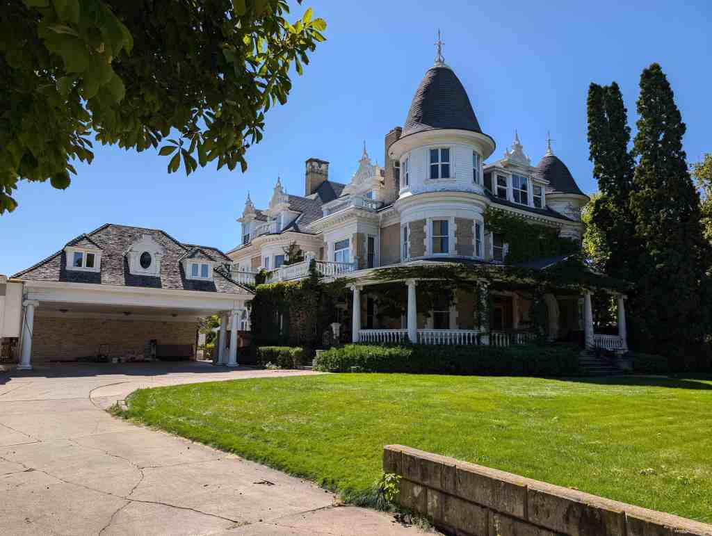
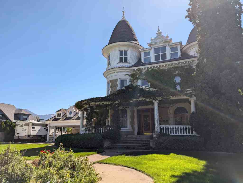
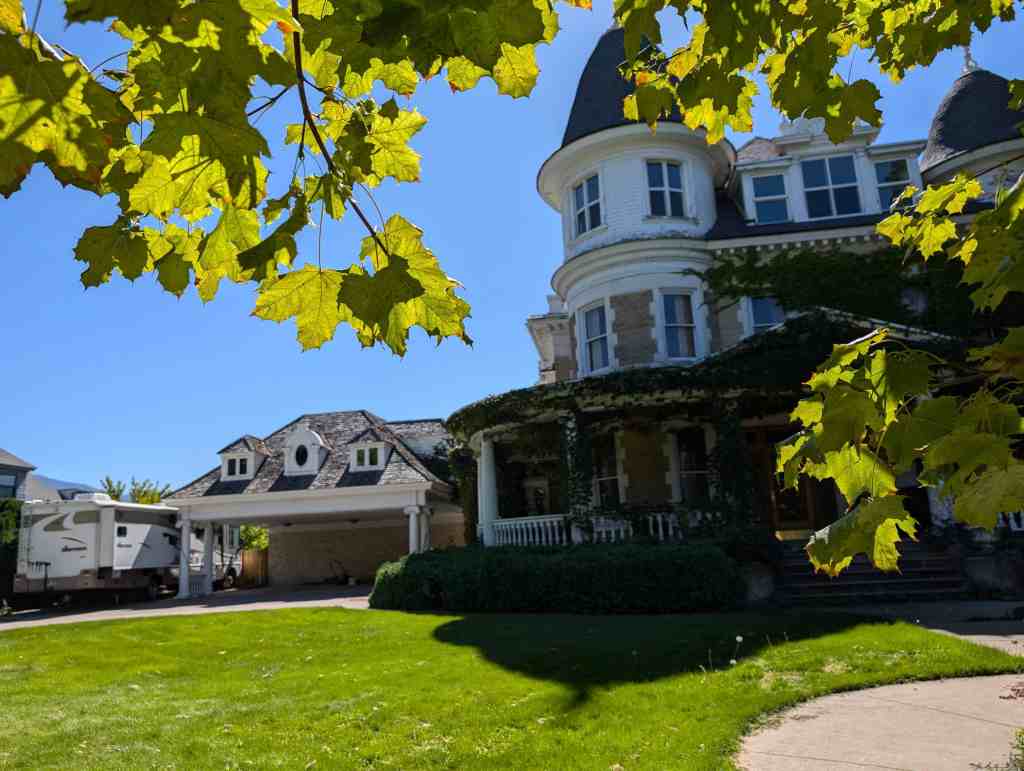
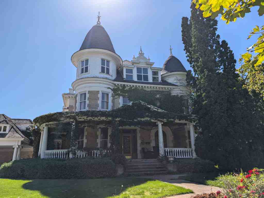
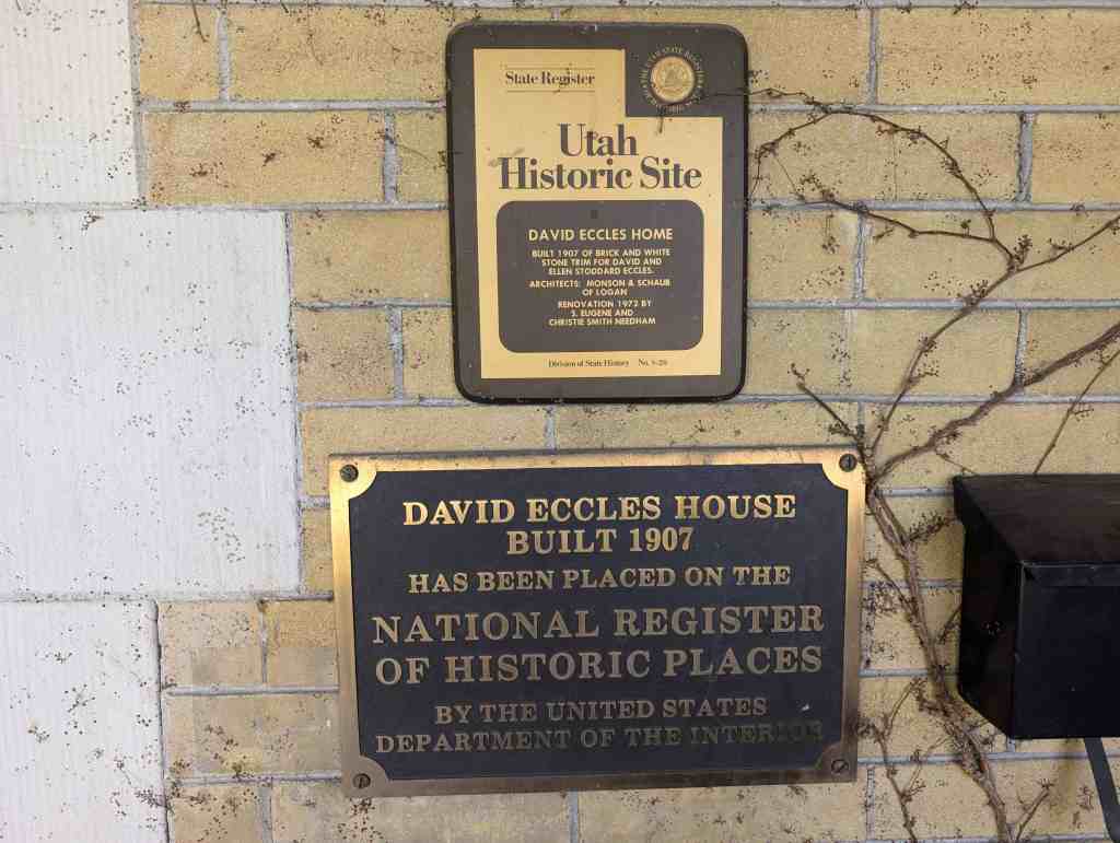
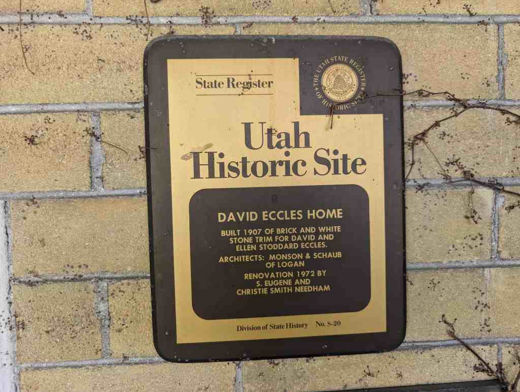
Built 1907 of brick and white stone trim for David and Ellen Stoddard Eccles.
Architects: Monson & Schaub of Logan Renovation: 1972 by S. Eugene and Christie Smith Needham
The David Eccles Home is located at 250 West Center Street in the Logan Center Street Historic District in Logan, Utah, it was added to the National Register of Historic Places (#76001811) on July 30, 1976.
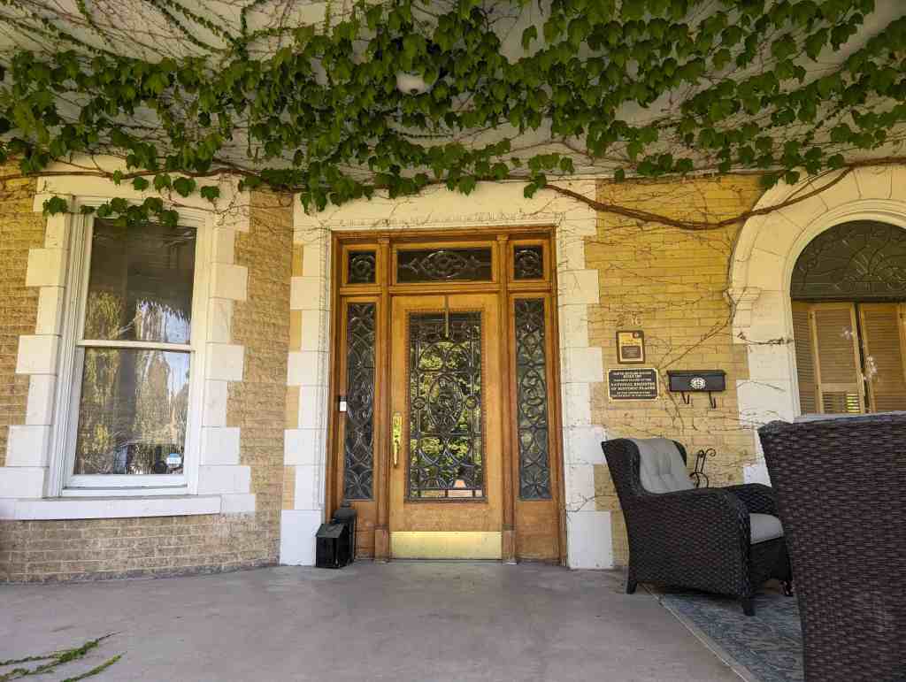
David Eccles built this home in 1907 for his second wife, Ellen Stoddard. It has 24 rooms and 11,000 square feet of living space. Emigrating from Scotland with his family in 1863, David Eccles became successful with interests in sugar, lumber, coal, and banking. The architects for the house were J. Monson and Karl Schaub. The style includes late Victorian, Chateauesque, and Neoclassical elements. Two large turrets and colonnades and a neoclassical porch dominate the façade of the beautiful structure. Of particular interest is the scrollwork on the front porch and the embossed abbreviation “D.E.” for David Eccles.
Throughout the house, decorative oak woodwork is prominent. Other features include 19 cut glass windows, detailed plaster cornice work, a large archway entrance to the living room, and hardwood floors. The house has been a university dormitory and fraternity and sorority house. Christie and S. Eugene Needham purchased it in 1970 and their renovation included adding a carport, a children’s play area, a formal garden, an art studio, and bedrooms.*
The David Eccles home represents several important themes in Utah and American history. As a poor emigrant from Scotland, the home symbolizes the successful business career of David Eccles and the important contribution he made to the economic development of the West. As the home of David Eccles’ second family, it is a unique part of the Mormon polygamy story. The home f s construction coincided with the end of the polygamy controversy after David Eccles became convinced he would be able to maintain both families in Utah without any interference. The home of Marriner Eccles during his last boyhood years, the site is also an important part in the history of this important figure in America’s economic history.
Architecturally the David Eccles residence represents the finer achievements of architects and builders responsible for the construction of the many late-Victorian period homes in the West Center Street area of Logan. The home is perhaps the best surviving residence designed by Logan architects Joseph Monson and Karl C. Schaub, both of whom were distinguished in their careers.
The David Eccles Home in Logan was constructed in 1907 at a reported cost of $75,000. The architects were Joseph Monson and Karl C. Schaub. Born May 12, 1849, near Glasgow, Scotland, David Eccles was forced to begin his business career at an early age when his father, a wood turner by trade, suffered almost a complete loss of sight from double cataracts on his eyes. Supplied with kitchen utensils made by his father and resin sticks used to ignite coal fires, the eleven year old David journeyed to neighboring towns to peddle his wares. In 1863, at the age of fourteen, David Eccles and his family emigrated to Utah with help from the LDS Church Perpetual Emigration Fund. After working in Utah and Oregon sawmills, and the Almy Wyoming coal mine, David took a contract in 1872 to supply logs to a portable sawmill. This venture led to further investment in the lumber industry first in Utah then Idaho, and by 1887 in Oregon. His success in the lumber industry made possible other investments in railroads, beet sugar refineries, food processing enterprises, construction, coal, land, livestock, banks, and insurance companies. After his death in 1912, his estate was valued at over six million dollars. During his business career he had founded 54 different enterprises. Because of his respect among both the Mormon and non-Mormon business communities, he was a leader in the secularization of business in the Mormon cultural region. His biographer, Leonard Arrington wrote:
To a poorly educated person from a family with no savings or social status, the only way out of poverty was hard work and careful use of time and resources. Eccles therefore concentrated his efforts toward the goal of accumulation. He did not expend his energies in “church activities,” nor in striving for social recognition, nor in unproductive political debate, nor in the pursuit of pleasure. Every moment, every ounce of energy, every expenditure had to count toward the goal of accumulation and profit. This was not a driving preoccupation but a a pattern of life he knew was right. He was neither tense nor humorless; he enjoyed his work and his endeavors to turn a profit. He worked with gusto, relished the attempt to make business succeed, found pleasure in investing in new enterprises. But he was careful, prudent, and shrewd. This was habitual with him and not just a “show” to induce a spirit of economy among his employees. Leonard J. Arrington, David Eccles, pp. 126-127.
In keeping with the standard set by prominent men of good standing in the Mormon Church before 1890, David Eccles married two women. His first wife and her family lived in Ogden and their home, now known as the Bertha Eccles Art Center has been listed on the National Register of Historic Places.
David married his first wife, Bertha Jensen, in 1875. Ten years later, in 1885, he married Ellen Stoddard a young girl eighteen years of age. Because of the pressure by federal officials to arrest Mormon men guilty of unlawful cohabitation, the marriage to Ellen was kept a secret. Ellen was well aware of the necessity for secrecy especially when her own father, a polygamist with four wives, was arrested and forced to spend several months in prison. During the late 1880’s, Eccles moved Ellen, her mother, sister and two brothers to North Powder, Oregon, near a sawmill built by John Stoddard, but then owned by his son-in-law David Eccles. In 1890, Ellen returned to her family in Logan where she gave birth to her first child, Marriner. With the fear of arrest for unlawful cohabitation still a threat to her husband, Ellen continued to keep her marriage a secret and while in Logan, carefully hung drying diapers under sheets on the clothesline in an effort to maintain her secret. Ellen remained in Utah and Southern Idaho until late 1894 when she returned to Oregon with her three children, Marriner born in 1890, Marie born in 1892, and Spencer born in 1894. Her father, a business associate of David Eccles in the lumber industry had made his home in Oregon and Ellen remained there until 1907. During her sojourn in Oregon, five more children were born.
After Ellen’s return to Logan in 1907, David’s relationship between his Ogden and Logan families settled into a comfortable routine. Leonard Arrington writes:
Eccles necessarily divided what time he had for domestic matters between his two families, so the responsibility for rearing their nine children necessarily fell to their mother Ellen. The oldest son of this family, Marriner, recalled, “she reared us all to share her own view of David as a man who was to be respected and loved, and not to be annoyed by noise and tumults on the occasions when he was home with us.” And his sister Nora concurred, adding that, even though Eccles kept unorthodox hours–in his later years he often came home as late as ten o’clock in the evening–her mother would attempt to have a full dinner for him, and a family of happy, if tired, children to greet him. The children loved to wait for his arrival. He would play games with them, such as dropping nickels and dimes on the sofa for them to find. When they would bring the lost coins to him, he would reply in his Scottish burr, “Losers weepers, finders keepers!” and laugh heartily. Leonard J. Arrington, David Eccles, p. 155. Marriner S. Eccles, Beckoning Frontiers: Public and Personal’ Recollections, (New York, 1951), p. 22.
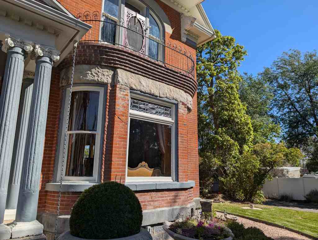
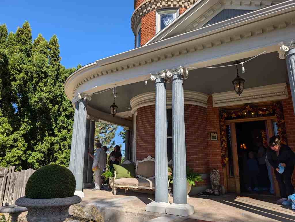
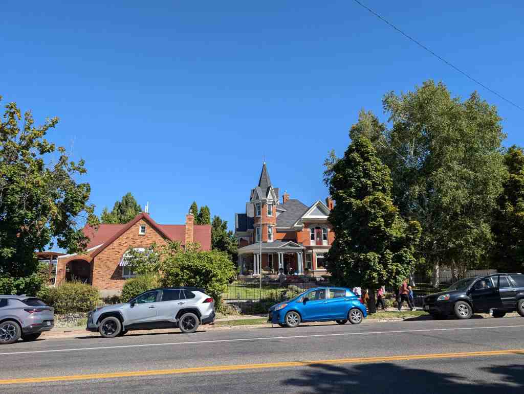
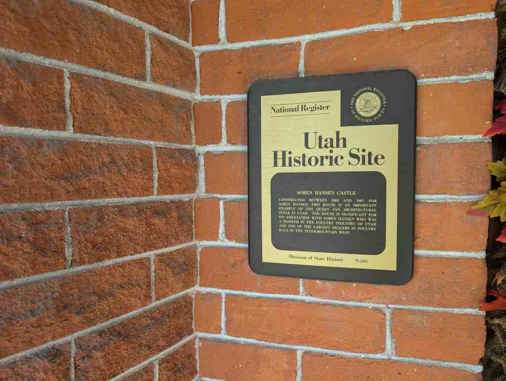
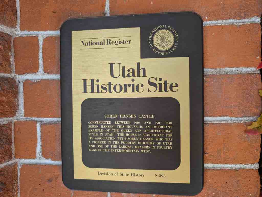
Constructed between 1905 and 1907 for Soren Hansen, this house is an important example of the Queen Ann Architectural Style in Utah. The house is significant for its association with Soren Hansen who was a pioneer in the poultry industry of Utah and one of the largest dealers in poultry eggs in the inter-mountain west.
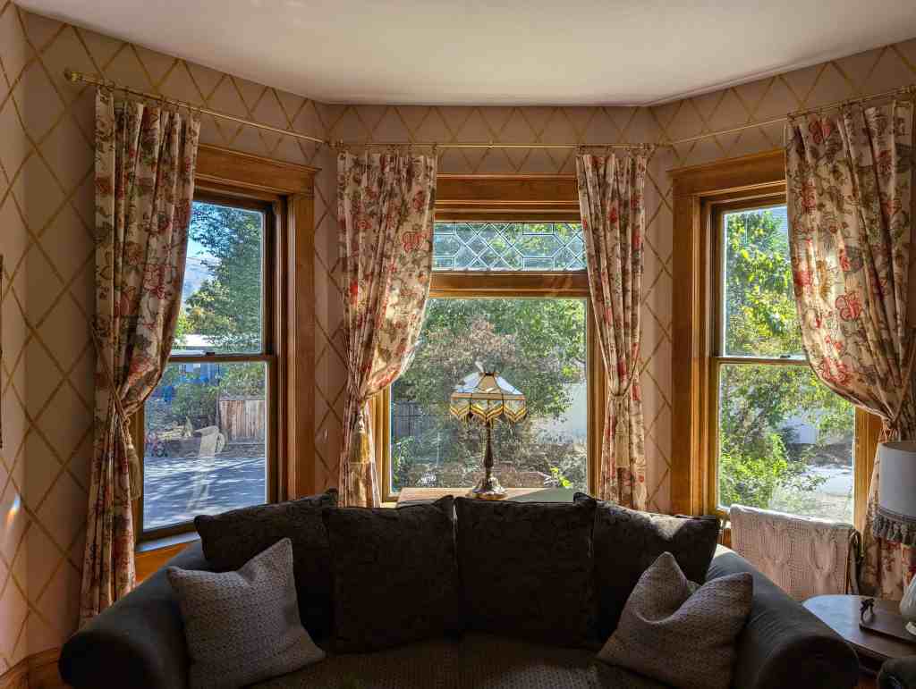
In pioneer days, eggs were used almost as much as money as a medium of exchange. Profits were good. Soren Hansen built a cold storage plant where as many as 4,000 cases of eggs could be stored. One year he stored several carloads of eggs and within three weeks’ time he had resold them for a profit of about $22,000. One autumn evening in late 1880, Soren told his wife he was going to build her a new home using the profit from his eggs. Their log cabin was replaced by this $30,000 Queen Anne home. In 1907, when this home was built, he told his wife, “This is the house that eggs built.” It was placed on the National Register of Historic Places in 1971. Notice the detailed woodwork and the extensive use of it in this home.
“The House that Eggs built” written by Soren Hanson Jr.’s son- Russell S. Hanson
Sometime between 1885 and 1890 father started in the egg business. He found it necessary to have some sort of storage facilities to store the eggs until he accumulated a wagon load to haul to Ogden. He built his first storage plant, which was nothing more than a cellar dug about five or six feet in the ground, with walls two to three feet thick filled with sawdust for insulation, and with a dirt roof. The cool air in the cellar permitted keeping the eggs for not more than sixty days. Undoubtedly the quality of the eggs when sold left much to be desired, but they were the best storage eggs available at that time.
The cellar storage was located about one hundred feet from the southwest corner of the large storage plant built some years later.
Despite the crudeness of this cellar storage plant, father continued to make good money selling his various products. In 1895 the egg business had become so good, and father prospered to such an the extent. that he decided too build a new and modern storage plant of a large enough capacity to carry the eggs from April, May, June, and July until the winter months, when the were sold to best advantage.
He took a trip back East and visited several plants. While there, he employed an architect to draw plans for his new building. He returned from the trip eager to start construction. Hyrum Hokenson, who had been buying chickens for father, was also a carpenter, and father put him in charge of construction. The new building was a large two-story structure about fifty feet wide by 120 feet in depth. It contained six rooms on the main floor. The first two rooms were uncooled. It was here that incoming eggs were unpacked and outgoing eggs were crated for shipment. The next two rooms were partially cooled and it was here that the candling of the eggs was done. Candling then was done in much the same manner as it is today except the light for the purpose was then supplied by kerosene lamps, while today and electric light is used. Through the candling process, it is easily determined whether the egg should be discarded because of defect, or held for storing.
The next two rooms were then called storage rooms. As I recall, they had a capacity of 4,000 cases of eggs. In the west end of these rooms were built huge ice tanks, which did the cooling. There were four of these–two in each room. They were five feet in diameter and thirty-two feet high. These tanks were kept filled with ice. If a lower temperature was desired in the storage rooms, hundred pound bags of coarse salt were poured over the ice. This made the ice melt faster and caused a lower temperature in the rooms.
We had large ice pond situated about one mile north of the cold storage on 2nd West Street. Here in the winter time the ice froze to a thickness of between eight and ten inches. This was cut with huge saws into cakes about twenty-four inches by thirty-six inches in size. It was then hauled to a large ice house adjoining the cold storage. It was stacked p in this building to a height of about twelve feet, until the building was filled. The ice was then covered with about ten inches of sawdust. This kept the ice from melting in the hot summer weather. The supply of ice was sufficient to maintain proper temperature in the cold storage until the next cutting season.
These huge cakes of ice were hoisted to the top of the building on a horse-drawn elevator. A child could lead the horse for this purpose as well as a man. We boys always had to lead the horse past the old “Rotten Egg Hole,” which stank to high heaven! Of course, the odor we had to endure was our own fault, as we were supposed to keep the rotten eggs in the deep hole covered with dirt.
To the south side of the cold storage plant, a salt house had been built. There was a second elevator on that side of the building for hoisting hundred pound bags of salt to the top of the building. We bought this coarse salt in train carload lots.
Just after the new cold storage plant had been finished, the first summer in fact, it was found that it was poorly insulated. The architect had asked that the hollow walls be filled with, of all things, sand. Sand is a conductor of heat, and an insulator. So, that fall if became necessary to “bleed” all the walls of sand, and fill them with sawdust, which is the perfect insulator.
On the north side of the storage there was a large “lean-to,” through which the wagons could be driven. This was built so that wagons coming in at night loaded with eggs, would be under cover until the next day.
In pioneer days. eggs were used almost as much as money, as a medium of exchange. Farmers, as a rule, would have anywhere from a dozen to two or three hundred chickens. They could take their eggs to any store and exchange them for merchandise, just as readily as money. Father purchased these eggs from merchants all over the valley. The profit was very good. Father made what was then considered a sizeable fortune in them. Eggs were often purchased for as low as eight cents per dozen, and then resold for many times this figure. I remember that we shipped eggs all over the Intermountain country, particularly to the mining towns of Butte, Anaconda, Rock Springs, Superior, and Winnimucca. Names of merchants were taken from the Dunn & and Bradstreet book of credit ratings. Father would mail penny post cards containing egg quotations to a long list of prospective customers every week or ten days. The eggs which cost Father $2.88 per case, or thirty-six dozen, usually sold for $6.00 or a little better, f.o.b. the railroad at Logan.
When father first started in the egg business, Cache Valley wasn’t served by the railroad, so he hauled them to the mining camps of Montana in a wagon with an eight-mule team.
I remember when I was a young boy, father often sent my brother, Fay, and me with our large wagon to Paradise, Millville, and Wellsville, to get the eggs which had been accumulated by the merchants in those towns. We would help load the wagons with eggs and haul them to the depot in Hyrum, and place them on the freight cars. At that time we were shipping eggs in carload lots. We would be paid for our work, but Father made a deal with us boys. For every dollar we put in our savings account he would match it with a dollar.
Father not only stored eggs in Hyrum in those early days, but he would also buy them in the Middle West and store them at the Beatrice creamery Company plant in Beatrice Nebraska. One year he stored several carloads of eggs this way, and in three week’s time he resold then for a profit of about $33,000.00 He told mother that he was going to use this profit to build her a new home.
It was an autumn evening in the late 1880’s. Soren Hanson sat in his log cabin watching his wife as she cleared the supper table.
“Some day I’m going to build a fine home for you.” he told her. “Oh,” she said, looking around the single room that was their home. “We can make do with what we have for awhile yet.” There was another room in the cabin, but it was used as a general store, which provided a living for the family.
Soren made good his promise. He built the house for $30,000. When it was finished in 1907. he took his wife in his arms and said, “This is the house that eggs built.”
“The House That Eggs Built” stands today in Hyrum, Cache County, on the same lot where the log house stood. It is a monument to the resourceful Soren Hanson–and a reminder of the happy times he furnished to all his town folk.
“The Meeting House and the Mermaid”
Source: This story was told to me, David Barkdull, by Gloria Hansen Wright, grand-daughter of Soren Hansen, in 2014.
At the end of the 19th century, Soren Hanson built a beautiful home on First North and a half a block west in Hyrum, Utah. This was the famous “House that Eggs Built” and is a “National Register” home. His brother-in-law, Peter Christiansen completed all the exterior metal work like the railing on the upper floors in his black smith shop. He was also a skilled carpenter and manufactured all the elaborate wood scroll work.
Soren also commissioned a stone engraving of a well endowed Danish mermaid, a topless one in fact. Even though such a depiction may have been acceptable back in his native Denmark, the land of the famous children’s author, Hans Christian Anderson who penned the “Little Mermaid”, it was not so in the proper little Mormon community of Hyrum, Utah. Soren’s scandalous “Little Mermaid” sculpture was placed high up on the chimney on the east side of his home for all to see. It simply was not acceptable for a partially nude woman to be displayed in such a public manner in those days. However, Soren was a fairly influential man of means in Cache valley so there was little anyone was willing to do or say, particularly since they were beholden to his considerable community generosity of which they had all benefited.
While Soren had been baptized at age eight into the Mormon faith, he was not a regular church attending member in the traditional sense. However, he had always been supportive of his wife and family’s church participation, he had always been a full tithe payer, supported other worth-while church and community endeavors, and had a warm regard for the faith of his parents and family.
In 1901, the old Hyrum pioneer church had out grown its usefulness and needed replacing. It had been some 40 odd years since the founding of the town and it had outlived its usefulness. During these years, the people had prospered fairly well and so it was decided that a proper brick edifice would be built. Construction soon commenced.
As the church neared it’s completion, Soren and his wife Eva decided to have a dinner party in their home and invited a number of townspeople. Lars Peterson, who was Chairman of the finance committee for the construction of the new chapel also attended. Following the dinner, the group was visiting and Soren asked Lars how the construction of the church was coming. Lars replied, “Didn’t you know, we ran out of money and had to stop the job?” Surprised, Soren asked him how much it would take to complete the building and Lars told him it would be about $17,000. “Well, I suppose I can stand that much” Soren replied and he wrote a check for the full amount right there that night. And so the Hyrum First Ward’s brick church was completed a short time later.
This story is related by Victoria Olsen Hanson, wife of Russell Hanson. It is a true Christmas story about a real Santa Claus with a heart of gold.
In the early days when Hyrum was in its infancy, about 1900, a prosperous young business man of Hyrum was always doing kind deeds for others. He conceived the idea of giving a real Christmas party for all of the people of the town, men, women, and children.
In preparation for the party he sent to a wholesale merchandise house (he had been a merchant,) for hundreds of gifts, barrels of candy, peanuts and walnuts. Among the gifts were harmonicas, umbrellas, balls, books, gold watch chains, and even violins and gold watches. Each child in the community received a lunch basket which was filled with candy, nuts, and other gifts. The basket also contained an orange. This was one of the most exciting gifts because oranges in Utah in 1900 were rare indeed. The party was held in the Opera house which this young man had built some years previous. The party consisted of a program and dancing besides a visit by Santa Claus who passed out the gifts.
Christmas parties similar to this were given for a number of succeeding years and they were fondly remembered by all of the people in Hyrum–men, women and children alike. This man of whom I speak was Soren Hanson.
A story of these Christmas parties appeared in the Salt Lake Tribune and it concluded by saying, “If the vote of every man, woman, and child in Hyrum could elect a president that man would be Soren Hanson.” To show their appreciation to Mr. Hanson’s kindness to them the children of Hyrum took up a collection of nickels, dimes, and pennies and purchased a sterling silver tea and coffee service which they presented to Mr. and Mrs. Hanson. On it were inscribed these words. “To Mrs. and Mrs. Soren Hanson for their Kindness To Us The Children of Hyrum.”
(Note: Some years ago I saw this tea set at the home of Mona Zundell, daughter of Soren and Eva. Having pictured it in my mind for years as rather grand, I was disappointed to see that it was a simple, rather inexpensive set. Not sterling, But none-the-less, given in gratitude. -Gloria Gene Hanson Wright)
The Historical significance of Logan and its historic district can best be described by historian Leonard J. Arrington who in an article on Cache Valley (wherein Logan is the commercial, educational, political and religious center) wrote the following:
The economic development of Cache Valley is unique in American history. Virtually all of the United States was settled and developed with “outside” capital. The Atlantic Coast states had extensive commercial connections with England, Northern Europe, and the West Indies, The Southeast, likewise, built its capital fund by exporting to England. The Midwest was developed primarily by eastern capital, while West Coast development was stimulated and financed by exports of gold, lumber, and wheat. Even most of the valleys in the Mountain states were developed by eastern and midwestern capital. Wyoming’s important range cattle business was largely financed by easterners and English-men; and the growth of Montana, Colorado, Nevada, and the Salt Lake Valley was largely induced by the immigration of mining capital from east of the Mississippi. Cache Valley, on the other hand, was settled by people who did not have capital when they came. This is one valley whose development was accomplished without the attraction of significant amounts of outside capital. Its people raised themselves, as it were, by their own bootstraps or rather, by their own bone and sinew. This is perhaps one reason why economic development was so slow. It also explains why the development was so solid and lasting.
The history of Cache Valley is also significant because it was one of the few economies founded for a religious purpose, dominated by religious sentiments, and managed by religious leaders. Some American states were founded for benevolent and religious purposes, and some were influenced for many years by religious attitudes and leaders, but there are few cases in which a church undertook such whole-hearted planning and organization for economic progress as in the case of the Mormon community in the Mountain West. Cache Valley’s settlers believed that God was with them. They regarded themselves as partners with God in subduing the earth and making it fruitful. They believed it was their solemn obligation and privilege to unite in building a Kingdom of God a Kingdom at once comfortable to live in and beautiful to behold. This unity in building a Godly Commonwealth gave flavor and distinction to the economic growth and development of Cache Valley.
The Logan Center Street Historic District is one of Utah’s Historic Districts and is bounded by ……. in Logan, Utah. It was added to the National Historic Register (#74001933) on April 26, 1979. The text on this page is from the national register’s nomination form.
Cache Valley’s history is significant, in the third place, because it illustrates the problems connected with the settlement of a semi-arid region. It is doubtful that any semi-arid region has faced up the particular problems involved in irrigation agriculture more resolutely, and documented the story more completely, than has Cache Valley. As the result, the valley is today one of the best watered in the West; its history and development are objects of study by scientists and technicians from as far away as Africa, Iran, and Australia.
Finally, Cache Valley history is significant because it represents in so many ways the pioneering experience which was typical of America. Dr. Ralph Barton Perry, in his justly famous book, Characteristically American, wrote:
Mormonism was a sort of Americanism in miniature; in its republicanism, its emphasis on compact in both church and polity, its association of piety with conquest and adventure, its sense of destiny, its resourcefulness and capacity for organization.
It was not only a Mormon dream, but the dream of all Americans to build on this continent a Kingdom of God. It was the dream of all Americans to escape, as Goethe said, from the past of European man, and to build a new society a good society. The history of Cache Valley is a kind of summation of American history, a heightening, a more explicit formulation of that history. Cache Valley history is thus a study of American problems, of human problems, of the problems of all individuals making a living on the frontier of civilization, .whether in Siberia, Argentina, or New South Wales.
Logan is the biggest city of the several small communities nestled in a beautiful northern Utah basin called Cache Valley. This “structural valley,” the largest of its kind in the Wasatch Range, resulted from a long period of faulting and breaking of the once level floor. The fault lines can still be seen in the foothills, and though millions of years old, they still have the ability to give the contemporary resident a scare when it decides to find a more comfortable place to rest for another generation or so. This faulting not only created the steep mountains which rise to levels of 9,000 feet and are 5,000 feet above the valley floor, but millions of years ago they became the rim of Lake Bonneville which left its own legacy. This great and ancient lake at one time covered 19,750 square miles and inundated most of Utah, Idaho and Nevada. As the lake began to leave the valley, its gradual decline brought down large amounts of gravel, silt, sand and clay from the mountains and deposited these unknowing passengers on the floor of the valley, thus making it unusually level. As the winds blew and the rains came and time passed, a fertile brown soil of about eight inches was placed on top of this high, but level floor of Mother Earth, and the result was a valley that was most suitable for agriculture if the suitor could only overcome the thorns of a rather stoic sky (when it came to tears) and a few million grasshoppers and crickets.
These two problems, though severe to any man seeking a quick profit, proved not to be so overwhelming to a group of settlers willing to work together closely and to patiently survive the first few desperate years until the groundwork for a successful economy could be laid.
The Settlement of Cache Valley
The Mormons, or members of the Church of Jesus Christ of Latter-day Saints, came to the territory, which is now Utah, in 1847 and first settled in the valley of the Great Salt Lake. They came to find a place in the West that nobody wanted where they could live and worship God as they pleased without conflict with non-Mormons.
Cache Valley is almost unique among Mormon settlements in that the settlers who came to build the cities in this valley were not “called” or assigned to go to Cache Valley by the great Mormon leader, Brigham Young. In the settling of Cache Valley, the pioneers came out of desire and love of the land, although they did get Brother Brigham’s blessing in the venture.
Cache Valley had been visited by mountainmen and trappers for years .before the Mormons came. In fact, Jim Bridger had told Brigham Young that this valley was probably as fertile as any around and certainly better than that of the valley of Salt Lake. But the nineteenth century Moses had already made up his mind on the valley to the south, and that is where the Saints first settled. But Young’s plans were for an empire expanding over the entire mountain west, and as soon as they had arrived, he began sending out explorers to evaluate other possible sights for his communities. Jessie C. Little headed for Cache Valley in August 1847 and reported that the valley was, “beautiful and had more timber than any place… explored. From an area of nine miles to nineteen and one-half miles, there were twelve streams flowing through a good country into the Great Salt Lake.” Fears of the valley’s killing frosts and harsh winters related to them by the trappers and the strength of the Shoshoni Indians, who considered the valley their hunting grounds, left the area free of Mormon settlers for a decade. However, the need for further expansion became more intense and in 1859 Peter Maughan received permission from Brigham Young to settle Cache Valley. Maughan and the several families that came with this seasoned pioneer founded a small community at the southwest end of the valley not far from the mountains through which they entered the valley. The community called Maughan’s Fort (later named Wellsville) immediately became the rendezvous spot for the flood of new settlers that surged into the valley in the late spring and early summer. Maughan encouraged the new settlers to find new sites and start new communities. He also advised them to follow his pattern of settlement– the fort style. This method of settlement was used extensively in the early days of Utah. The log houses and dugouts were very close together, but they were separated by a fence that encompassed a back yard of substantial size for the stock. All the houses were arranged inside a perimeter fence or stockade. One long street divided j the two rows of houses with a gate at each end. The fort style had several advantages. Most important, it aided in protection against Indian raids. The Shoshonis, though basically nomadic, considered Cache Valley their hunting grounds, and they were naturally disturbed to see the settlers come and compete with them for the wildlife and to turn their pristine valley into a civilization they could not comprehend. On numerous occasions, there were confrontations and killings. One Wellsville citizen explained the Indian experience this way:
We had a pretty hard time for three or four years to make a living. We had many times to guard the fort at nights and herd our stock in the day so the Indians could not steal them. In the summer of 1859, the Indians stole every horse that was out on the range.
The fort style protected the settlers from possible intrusions, but it also gavel unity to the town and provided a sense of belonging which most emigrants needed as much as any physical object. One settler explained other advantages of the fort style:
… a splendid lesson had been taught and learned, it being really necessary to love the neighbors, their doors being only half speaking distance apart, which however was quite convenient in one respect, as people had to 5 borrow to quite an extent, it was not a great task to borrow and return.
The influx of new settlers brought on a settlement bonanza in 1859. In just a few months, Providence, Logan, Hyde Park, Smithfield, Richmond, and Mendon were established, creating a chain of closely linked villages instead of one overgrown town. The next year brought three more communities into existence in the valley of the north, making a total of ten village settlements in just two years. All of these communities used the fort style settlement thus rejecting the homestead method of western pioneering so common in all other western territories. This unique form of western settlement also helped the town life so deeply ingrained in the Utah way of life.
Logan’s Rise to Prominence
Logan’s birth came in June when two groups of settlers built their homes in the fort style along present day Center Street for about two blocks. The next year another block was added to the nascent, but burgeoning community. Most of the houses in this vernal village were built of logs with dirt floors and dirt roofs. Despite this terrestrial beginning, Logan became the most prominent town in the valley because oftwo reasons. First, it was about equal distance from the outlying communities which automatically gave it the cardinal position in the valley. Second, because it was settled on the banks of the Logan River, it gave the community the greatest source of water supply of any place in the valley. The chart below shows Logan’s tremendous growth compared to the other communities of the valley.
Population of Cache Valley Communities in Various Years:
1870
1880
1890
1900
Wellsville
885
1,193
1,045
908
Logan
1,757
3,396
4,620
5,451
Smithfield
774
1,177
1,386
1,494
Hyrum
708
1,234
1,423
1,652
Though settled in 1859, Logan and all other communities in Cache Valley were not incorporated for several years after settlement so the Mormon Church’s ecclesiastical leaders fulfilled this political void while maintaining the religious leadership of the communities at the same time. William B. Preston was chosen to be the Bishop of Logan in 1859 by Mormon Church Apostles Orson Hyde and Ezra T. Benson.
By 1864 the threat of the Indians had been minimized by the United States Army which had defeated the Shoshoni Indians in a battle the year before. So that year the county surveyor, James H. Martineau, and the territorial surveyor, Jessie W. Fox, surveyed and platted the town, making it ready for the establishment of city lots. Also that summer, Brigham Young visited Cache Valley and advised the settlers accordingly:
There are a few trees here. Raise orchards, if only for the welfare of your children…. Why not quarry rock and build stone houses and make stone fences? Stone makes a good fence and it will not winterkill. Build good fences, have good gardens and make yourselves happy, serving God…. Build meeting houses, put up the lumber and make bins in which to put up your wheat so that it can be safe for fifty years if needed.
As soon as these faithful followers of the “modern-day Moses” received their city lot (given to them by Bishop Maughan), they did just what President Young had advised. For the Mormons came to Utah and Cache Valley because they wanted a place where they could reside and worship as they pleased and build a kingdom for their God. There was no desire to exploit the natural resources of the area and then take the wealth from that exploitation back east for a prosperous life among the affluent. ( Such ethereal goals, however, would take time and determination. So the Mormons built sturdy rock homes because they were here to stay. Four of these rock homes (#100, 602, 600, 348) are still standing and are important elements of the district because they not only represent the first stage of the city’s developmental process, but they also signify the pioneer’s intentions of permanency. Since the wood and stone used to build the homes was all garnered locally, they are-excellent examples of vernacular architecture.
There is one other aspect of early Mormon culture represented in one of the rock homes in the district, and that is polygamy. Polygamy or plural marriage was a tenant of the Mormon religion until the federal government forced the church to stop the ; practice in 1890. The George L. Farrell home (#100) in the district was a polygamy home, and its survival explains much about that controversial Mormon Doctrine.
Logan and the City of Zion Plan
By 1864 the city had now been surveyed and laid out and the properties deeded, ! though in fact, they were just squatters on public domain since the land still remained officially in the hands of the federal government. But what was the plan of the city? The settlement of the city and its plans for future growth had been worked out long before the pioneers had ever come to Cache Valley. The founder of the Mormon Church, Joseph Smith, had determined the city plans for the “ideal” Mormon community in 1833.
“This ideal city was to be one mile square, with ten-acre blocks, divided .into one-half-acre lots, one house to the lot; a complex of temples was located on two city blocks. The ideal, according to Joseph Smith, was to fill this city then another one next to it, and so on as needed to fill up the world in these last days.”
The plan was modified a little in regards to the number of temples in the area, but the rest of Joseph Smith’s ideal was applied to Logan with great care, thus formalizing the village concept. Each family received a town lot of about an acre and a quarter upon which they were to plant their vegetables and small orchard as I well as their home. In addition to the city lot, each family was given approximately two farm tracts to plant their crops. The tracts were situated on the perimeter of l the city lots just a short distance from their homes. This required a daily ride to their farms, but it also continued the close” relationship of the fort style life that, the settlers had previously known. This village lifestyle allowed for the close contact of the individuals with one another, thus allowing the development of culture through schools, neighborhoods, entertainment, commerce, and, of course, churches. Out of this lifestyle, unique forms emerged which contradicted some of the traditional frontier methods. For example, no one could own the water, though anyone could receive a share providing he did his part in the construction or maintenance of the canals. A similar condition existed with timber and to some extent land. New arrivals to these early communities received land allocations without charge.
The plan of Zion, as mentioned, set aside ground for particular buildings, namely a meeting place and a temple, and in 1865, excavation for the construction of a tabernacle began. However, for several reasons, the construction of the religious and public ediface was delayed and the tabernacle was not finished until 1891. This impressive structure has been used for all the conferences of the Mormon Church as well as many public meetings and performances. The structure is still standing and is an integral part of the district. Once again, most of the material for the impressive building is local, including the rock of which it is built.
The crowning stage of the implementation of the City of Zion Plan was the construction of a temple. Logan began the construction of this magnificent stone structure in 1877. The raw materials for the construction of the temple again came from the local canyons, and the work and the demand for the project created a virtual boom town atmosphere in the valley. The project took seven years of intensive labor and sacrifice from the valley citizens. Today, this beautiful edifice is still the symbolic structure of the valley.
Logan’s central location and its excellent water supply soon made it not only the religious center of the valley, but the economic and financial center as well. By the mid-eighties, the two major streets of the town, Center and Main, became the commercial center of the entire valley. These streets are still the center of the valley’s commercial district with some of the buildings dating back to the 1860’s. Most, however, are late nineteenth and early twentieth century. By the eighteen- nineties, Logan had progressed beyond the pioneer stage and was now entering into the! mainstream of American life. The town began to show the physical effects of the desire to be accepted by the rest of the American society.
Cooperative Economic Activities
It is interesting and significant to see how the basic needs of these pioneer settlers were met. The first problem of the pioneer settlers were those of survival – a thing which proved to be more difficult than most had anticipated. Fortunately, in the compact, well-organized villages, and in the habit of working together cooperatively, the early settlers possessed institutions aptly suited for meeting the enormous difficulties which were to arise. One of the most serious problems was the need to get the water from the many rivers to the land on which the pioneers used as farmland. Since the land immediately adjacent to the Logan River was designated as the townsite, the settlers had to somehow divert the water from the river to their farms some distance away. Irrigation canals were the natural answer, but this large task could not be done by the individual. Therefore, cooperation was used in the solving of the irrigation problems. As early as 1860, canals were in the process of being constructed. It was an immense project, one that took backbreaking efforts and a great deal of time despite the use of cooperation. One pioneer remembers that, “The man who could shovel the most dirt or cut the most hay or grain, or bring the largest load of logs or wood from the canyon was the hero of the community in those times.” Even today the very canals which were built over a hundred years ago are still in use and are a significant part of the district.
Another need of the Logan founders was lumber with which to build their homes, fences, and barns. The valley floor was virtually absent of trees and so were the adjacent mountain sides. The kind of lumber needed for building was far back in the canyons and quite inaccessible, especially for the individual. So once again, the Mormon pioneers relied on cooperation to solve the problem. Together, the settlers first built roads to the canyons and then cooperatively cut down the necessary timber and hauled it to the sawmills that were being established to cut the timber into usable lumber for construction.
The difficulty of this task delayed the use of wood frame houses for some time, do the first homes were either adobe homes or dugouts. Even with this cooperative method,
Homes and building development evolved slowly from the early dugout to the dirt-roofed log cabin, to the shingle-roofed log cabin, to the adobe and rock structures so popular in the 1870’s and 1380’s, to the “gingerbread” frame houses of this century dependent almost entirely on material imported into the valley from the outside.
The Coming of the Railroad
The material from the “outside” had to await the coming of the “iron horse” , which is another example of the cooperation in this Mormon community. Since the coming of the railroad to Utah, Mormon Church leaders immediately began sponsoring construction of interior branch lines to facilitate and expedite transportation through the principle settlements of the territory. The fourth of such projects was the construction of the Utah Northern which ran from Ogden, Utah to Logan. The Utah Northern was organized on August 23, 1871 with Logan Bishop William B. Preston vice-president and assistant superintendent. The directors of the company consisted almost entirely of Mormon bishops along the route the train was to go. The method of construction was as follows:
The plan of construction called for the appointment of superintendents in each of the major areas of construction. Labor was to be recruited directly by these men or through local bishops. Each priesthood-bearer was expected to do his share of the work. The men were to be paid principally in stock in the railroad, but in cases of necessity a certain amount would be given workers in “ready pay.”
The company broke ground at a religiously directed dedication ceremony on August 1871 and by January 1873, the track had been completed to Logan. Virtually all the wards in Logan participated in the construction work receiving only railroad stock for pay.
The citizens of Logan were so excited with the completion of their railroad that when a severe snowstorm stopped the train that winter, several hundred people turned out to break the blockade.
The railroad had a tremendous impact on Logan as it did when it came to other isolated communities, bringing it more into the national picture economically and culturally. But like many early railroads, the Utah Northern soon went bankrupt and its property was sold to the Oregon Short Line in 1877 which in 1899 sold out to the king of railroads the Union Pacific. Five years prior to this last sale, the Oregon Short Line constructed the present beautiful rock depot. This sturdy rock station is still standing and is the western boundary of the district.
United Order Manufacturing and Building Co.
Another good example of the cooperative efforts of Logan’s citizens was their practice of economic cooperation in the business sector also. In 1875, the Logan LDS Second Ward combined two private mills owned by members of the ward into the United Order Manufacturing and Building Company. This cooperative was designed to give employment to the members of the ward and all “good Mormons” were expected to patronize it rather than the gentile store. The store was a huge success and became the biggest lumber mill and building company in the valley. The most prominent structure that it built and which is still standing is the Cache County Courthouse constructed in 1881-82. The building is a beautiful, white brick, Neo-classic structure that today is the oldest functioning courthouse in the state of Utah and is one of the landmarks of the district.
Summary
Logan’s historic district contains most of the elements of the various stages of growth in the town’s past and is, therefore, an excellent microcosm of the colorful past of this northern Utah community.
The first stage of development in the community was the establishment of the fort style mode of village life. The heart of the district is on the very street that came into existence as a result of the fort style pattern and after which the district is named. There are even a few log cabins and adobe structures left depicting the j very earliest elements of beginnings in the town. The next stage of growth and progress is exemplified by the rock homes which are present. These stone structures represent the sense of permanency that was instilled in the minds of the early pioneers despite the serious challenges of Indians, grasshoppers, crickets, and drought. One of the rock homes also symbolizes another aspect of the early Mormon pioneers lifestyle; for it was a polygamy home. These adobe and rock homes represent the ability of the pioneers in the early stages, for they were well built and their use of totally local materials makes them excellent examples of vernacular architecture.
The district is also a superb example of the “City of Zion” plan of town life. The blocks inside the district are ten acres each, and the original plats show that the blocks were divided into eight equal lots which were big enough for a home, barn, vegetable garden, and stock corral. These large lots have since been sub-divided with the growth of the town, but the style of early development is very much present. Further, the central elements of the “City of Zion” plan are still the central elements of not only the district, but the town as well. The temple, sitting high on the east bench still is the structural symbol of the valley. The tabernacle is very prominent as well for it continues to watch over downtown Logan as the early pioneers believed God watched over them.
The canals of the early pioneers that carried the valley’s life blood to the outlying farm lots are still in use and in the district. The canals graphically express the determination, vision and skills of the fathers of Logan City.
Finally, the styles of the later period (1890-1915) which were the styles that were popular in other parts of America and are the ones that now dominate the Center Street are there as if to say, “Accept us America.” We are part of the whole and are here to stay.
Verbal Boundary Description
The northwest corner of the district begins approximately 100 yards northwest of the Union Pacific Depot and runs east to Forth west along backyard properties lines off Center street. At Fourth west it runs north to First North and then east to Third west and then north again to Second north. The boundary then runs basically east to the north east corner of Third East and Second North with some intrusions left out of the district. From the northeast corner of Third East and Second North the boundary runs south to First North and then west to Second East. The boundary then follows the canal to Center Street and then west to first East, then south to First South. The boundary then runs west to a point approximately 100 yards south of the corner of Fourth West and First South. From here it goes north to the back property lines off Center Street and then west to approximately 100 yards southwest of the Union Pacific Depot then runs due north to the point of the beginning.
Logan Center Street Historic District, Cache County, Utah. The northwest corner of the district begins approximately 100 yards northwest of the Union Pacific Depot, and runs east to 400 West along the backyard property lines of the buildings facing south on to Center Street. At 400 West the boundary turns north running to 100 North where it turns east down the center of 100 North to 300 West where it turns north again running approximately three quarters of the length of the block to a point just north of 154 North 300 West where it turns and runs east through the block to the north of 165 North 200 West facing east on 200 West. Continuing across 200 West it makes a quick or short jag back to the south before continuing east again just north of 162 North 200 West where it turns south running along the back property lines of the buildings facing west on 200 South. At the point where it reaches 100 North the boundary turns from the south continuing east to 100 West where it turns north running up 100 West to 200 North. At the corner of 100 West and 200 North the boundary turns east again running along the southern side of the street to the center of the block between Main Street and 100 East. At this point just to the west of a non-contributory building the boundary line turns south running to the middle of the block where it turns east again running through the middle of the block to 100 East Street. At this point it turns up 100 East Street north to the northside of 168 North 100 East where it turns east again running east through the middle of the block to the back property lines of 183, 181, and 165 North 200 East where it turns north again passing on the north side of 183 North 200 East to 200 East. The district boundaries then continue east, then south, then west again around the Logan Temple Block to a point at the intersection of 100 North and 200 East where it turns south to the southern boundary property line of 192 East 100 North, then west to the back (west) property line of 192 East 100 North. It then turns south running along the back property line of the buildings which are all non-contributory facing east on 200 East. The boundary continues south to Center Street where it then turns north again running up Center Street to 100 East, then south down 100 East to 100 South where it turns west up 100 South, then south again and west again around 1420 North 400 West, then north again back to 100 South where it continues along 100 South. Then it runs around 1301 North 600 West on the south side of 100 South and along 100 South to 200 West where it turns south, then west again around the back property lines of 154, 136, 132, and 120 South 300 West and 294, 288, 272, 256, 246, 244, 236, and 226 West 100 South which face north on 100 South. It then turns south along the back property lines of 202, 198, 192, 184, 164, 154, 136, 132, and 120 South 300 West running south along the back property lines of those buildings to 200 South where it turns west along 200 South, then north again along the back property lines of 125, 131, 145, 155, 163, I’ll, 179, and 191 South 300 West which face east along 300 West. The district then turns west again along the back property lines of 394, 386, 368, 374, 362, 350, 338, 326, and 320 West 100 South running west along the back property lines of these buildings facing north on 100 South. The line continues west to 400 West where it turns north up 400 West to a point just south of Center Street where it turns west running along the back property lines of 570, 562, 554, 530, 528, 520, 510, 502, 494, 478, 470, 454, 444, and 432 West Center which face north on Center Street. Running along the back property lines of these buildings, the boundary line goes west to a point approximately 100 yards from the southwest corner of the property lines of the Union Pacific Depot where it turns north back to the point of beginning.
The George Washington Baker house in Mendon, Utah (located in Cache Valley), was constructed in 1869 and is significant as an example of a one-story stone “double-pen” vernacular type. This house form, with its distinctive six-bay, double-door façade, is significant as one of a small number of traditional house forms common in Utah communities during the 1850-80 “pioneer” settlement period. The “double-pen” type migrated out of the upland South into the Midwest during the early nineteenth century. There it was utilized by early Mormons and transferred to Utah in the late 1840s and 1850s. This dwelling was the home of the George VI. Baker family, and remains one of four stone houses that exist in original condition from the early years of Mendon’s settlement.” The James Gardner House was listed in the National Register in 1982 and the Samuel Baker, Joseph Baker, and James G. Willie stone houses will be nominated to the Register in December 1982. Baker was an early settler in Cache Valley and one of Mendon’s original inhabitants. He was a farmer and in 1870 served as the first mayor of the incorporated town of Mendon. The small two-room house was enlarged around 1875 with a stone addition of several rooms to the rear.
Located at 115 N 100 W in Mendon, Utah and added to the National Historic Register (#83004416) on February 10, 1983.
Mendon, in Cache Valley, Utah, was settled in the 1856-60 period by members of The Church of Jesus Christ of Latter-day Saints as part of the larger colonization of the Great Basin region during the second half of the nineteenth century. In the 1850s, Cache Valley served primarily as range land for the LDS church livestock herd, but in 1856-57 the Valley became the home of a small band of farmers. The effort to settle the area was temporarily interrupted by the Utah War of 1857 when an army was dispatched from Washington to quell the so-called Mormon “rebellion.” At this time, outlying colonies were abandoned and settlers pulled back to the larger towns. Mormon families came back into Cache in 1858 and permanent settlements were established, including the one at Mendon on the west side of the valley. Mendon was surveyed in 1859, and in 1860 a fort, consisting of two rows of joined log cabins, had been erected.2 The year 1865 found the people of Mendon breaking up the fort and moving out onto their city lots. The first permanent houses were built at this time, often of locally quarried stone. George Baker completed the original section of his new stone house in 1869.
George Baker was born in 1837 in Pomfort, New York. His parents were converts to the LDS church and migrated westward to Utah in 1847, settling first in Salt Lake City. During the 1850s a young George Baker worked as a herder on the LDS church ranch in Cache Valley and eventually made the area his home in 1860. Baker built one of the log houses in the Mendon fort and in 1861 married Agnes Richard. By 1862, the first of the Baker’s ten children was born. George’s brother, Joseph, constructed the first rock house in Mendon outside the fort in 1865 and George began work on his own house soon after, finishing the dwelling in 1869.
The house Baker built was a traditional type consisting of two square rooms under a gable roof. Historians have often called this house the “double-pen” type. The house form migrated out of the upland South into the Midwest during the early nineteenth century. There are Mormon examples of the type in Nauvoo, Illinois, their city on the Mississippi, and the house occurs throughout the Mormon settlement region in the West. The house often has a four- or six-bay façade with two front doors arranged symmetrically.. The presence of the two front doors has caused this house to be erroneously called a “polygamy” house. There is, after all, a door for each wife. This house type might certainly have served such a purpose, and indeed, examples can be found in the state which were occupied by two families. Yet, the double-pen type’s firm roots in the traditional architecture of the nineteenth century and single family examples like George Baker’s served to effectively dispute it’s exclusive association with polygamy. The double-pen house is typical, then, of the early domestic architecture of Utah and becomes significant as one of several stone houses remaining in Mendon from the early years of settlement. (The Robert Gardner House, c. 1875, was listed in the National Register in 1982. Research is continuing on the remaining half-dozen early homes in the town for possible nomination.)
The George Baker house in Mendon, Utah, is a one-story vernacular house constructed of locally quarried metamorphic stone. The walls are coursed rubble, with special attention devoted to the regular jointing on the façade. There are large ashlar quoins at the corners. The stonemasons who worked on the house are not identified in the Baker family records. It is known that two Cache Valley masons, Robert Crookston and Robert Murdock, worked in Mendon, but no specific information is available to link these individuals with particular houses. Also, the 1870 census for Mendon includes Richard Mills, an immigrant mason from England, who could have assisted in the construction.
The original 1869 house consisted of two roughly square rooms (15’4″ x 14’4″ and 14’6″ x 14’4″ the difference being the width of the internal partition). The house had a symmetrical six-bay façade and two front doors. There was a large, centrally placed stone fireplace in the south room. External ornamentation was limited to Greek Revival returns and entablature. The sills and lintels are plain. The house originally had a porch spanning the length of the façade, but it was removed after the present owner purchased the dwelling (ca. 1940s). A rear “T” extension also of coursed rubble stone, and containing two rooms, was added to the house. Judging from the quality of workmanship and material, this addition probably occurred in the 1870s. A lean-to shed was attached to the north side of the rear “T” in the 1940s and the large central fireplace was removed at this time. Later, after the porch was removed, hooded coverings one a gable and the other a shed roof–were placed over the two front doors. These alterations do not detract from the historical visual integrity of the Baker home. The structure remains in good condition with some deterioration evident on the external woodwork.
From A sampling of cache valley’s historic homes: Built in the 188os (est.), the house was originally owned by Mary Ann Weston Maughan, wife of early Cache Valley pioneer Peter Maughan. Their grandson, Russell, was a pioneer pilot and fighting ace during World War I. On June 23, 1924, he made the first dawn to dusk flight across America. The media called it the “Maughanumental Achievement.”