• About JacobBarlow.com
  • Cemeteries in Utah
  • D.U.P. Markers
  • Doors
  • Exploring Utah Email List
  • External and Referral Links
  • Geocaching
  • Historic Marker Map
  • Movie/TV Show Filming Locations
  • Oldest in Utah
  • Other Travels
  • Photos Then and Now
  • S.U.P. Markers
  • U.P.T.L.A. Markers
  • Utah Cities and Places.
  • Utah Homes for Sale
  • Utah Treasure Hunt

JacobBarlow.com

~ Exploring with Jacob Barlow

JacobBarlow.com

Tag Archives: Emigration Canyon

Emigration Canyon

09 Monday Sep 2019

Posted by Jacob Barlow in Uncategorized

≈ Leave a comment

Tags

Emigration, Emigration Canyon, Emigration Creek, NRHP, Salt Lake City, Salt Lake County, utah

Emigration Canyon is home to Emigration Township, it is one of the National Historic Landmarks in Utah and it was added to the National Register of Historic Placed on October 15, 1966 (#66000737).

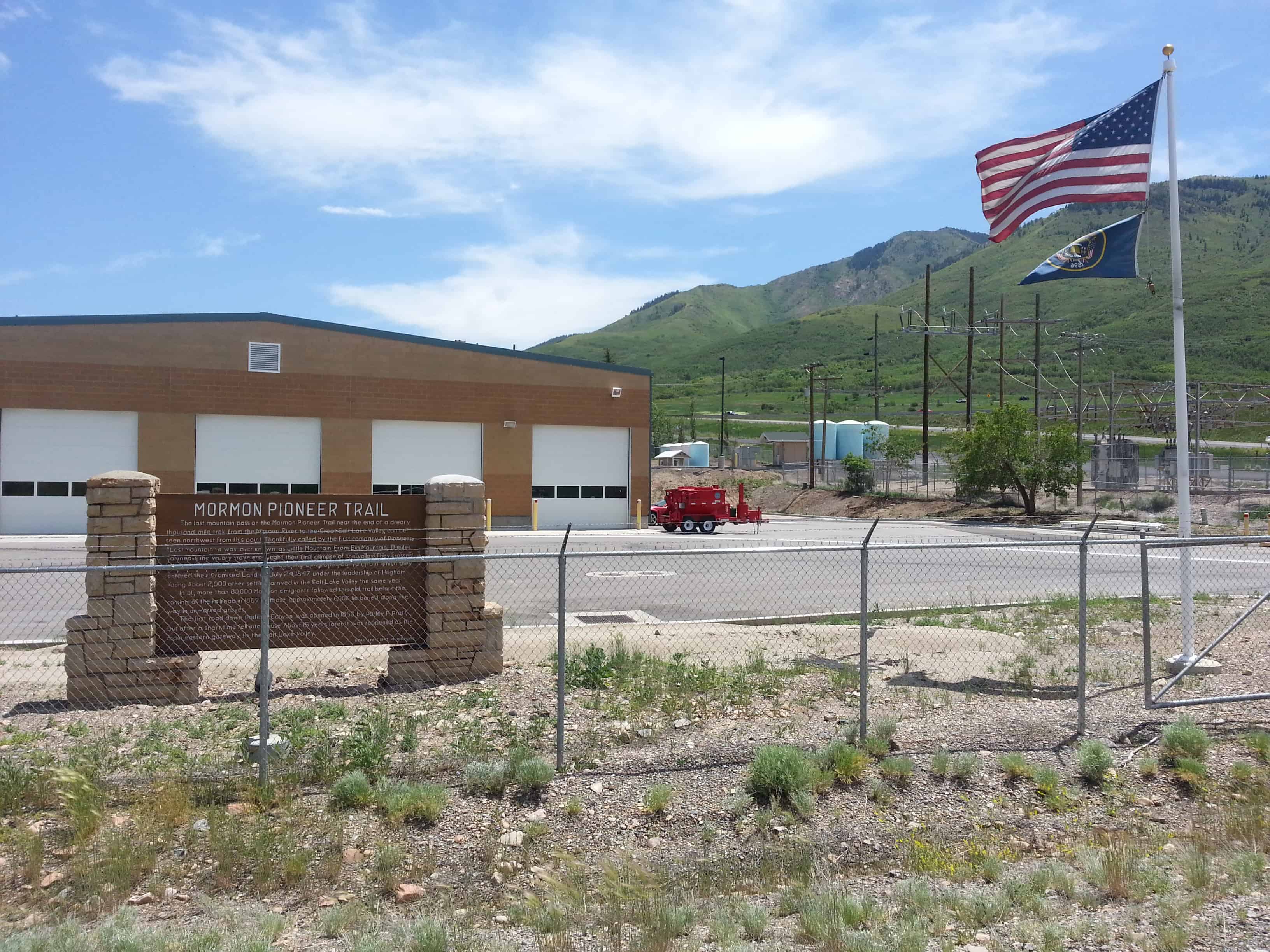
Emigration Canyon National Historic Landmark derives its historical significance primarily from association with the original “Mormon emigration of 1847. Brigham Young led the trek westward from the Missouri Valley through the rugged Wasatch Mountains. Threading his way down Emigration Canyon, tradition holds that Brigham Young first obtained an unobstructed view of the valley from the grassy knoll where the native stone monument now stands. Upon ascending this small hill, he is purported to have declared, “this is the place.” The route pioneered by Young and his followers later became known as the Mormon Trail, and was the path followed during future migrations to the Great Salt Lake Valley until 1850 when Parley Pratt pioneered the Golden Pass Trail south of Emigration Canyon.

The landmark boundaries envelope a thin belt of unspoiled landscape punctuated by small grassy knolls within Pioneer Monument State Park. Upon the tallest knoll, Mormons erected “Pioneer Monument” in 1947 to commemorate the early Mormon emigrants. The native stone monument features a 60′ pylon surrounded by bronze figures of Brigham Young, Heber C. Kimball and Wilford Woodruff. Bas-relief scenes in bronze around the 86′ base illustrate numerous historical events associated with the Mormon exodus from the Missouri Valley. .From the small promontory, one can obtain, an unimpeded panorama of the magnificent Salt Lake valley. The tone monument,. was designed by Mahonri M. Young, grandson of Brigham Young.

A sign in Allen Park tells of some of the history of Emigration Creek and Canyon:

In 1847, the first party of Mormon Pioneers entered the Salt Lake Valley through what we now know as Emigration Canyon. Tradition holds that this is where Brigham Young first views the valley unobstructed and said “This is the right place, drive on.”

Within days of settling in the Salt Lake Valley, the water of Emigration Creek was diverted for irrigation. The diversion established the first water right in the valley.

The hydrology of Emigration Canyon attracted pioneers to take up residence along the creek, clearing dense vegetation in favor of fields and pastures. Pollution from livestock deterred the City from protecting Emigration Canyon as a watershed, opening the area to development.

An early 1800s building boom prompted the extraction of red and white sandstone in Emigration Canyon. An electric railway system was installed in 1907 to meet the high demand but was dismantled a decade later as concrete became the preferred foundation material.

In 1931, Mr. & Mrs. Hogle donated land near the mouth of Emigration Canyon to became the new site for Salt Lake City zoo, now known as Hogle Zoo.

Record snowpacks in 1952 and 1983 caused hundreds of Salt Lake City blocks to be flooded. Excessive spring runoff in 1983 cased 10 million dollars of damage in Parleys, Emigration, and Red Butte Creeks.

Little Mountain Summit

11 Saturday Feb 2017

Posted by Jacob Barlow in Uncategorized

≈ Leave a comment

Tags

Emigration Canyon, Historic Markers, Salt Lake City, Salt Lake County, SUP, utah

2017-04-06 10.31.44

SUP #51 went missing, replaced as SUP #187

This is the last summit in the Wasatch Mountains along the pioneer trail. From this point the trail descends northwest until it reaches Emigration Creek. As William Clayton’s emigrants guide warns, “The descent is very steep all the way.”
The Donner Party passed over the summit August 21, 1846 and the Mormons on July 21, 1847.

Note: This monument was refurbished by the Salt Lake City Chapter SUP and dedicated on July 21, 2015 as SUP monument #187. The plaque indicates a dedication date of May 2015 – however the dedication was delayed due to considerable rain during May and June.

See other SUP Markers here.

2017-04-06 10.32.13

2017-04-06 10.31.57
2017-04-06 10.31.59
2017-04-06 10.32.09

2017-04-06 10.32.40
2017-04-06 10.32.25
2017-04-06 10.32.21


Older photos:

20130611_134952

20130611_134932
20130611_134935
20130611_134938
20130611_134940
20130611_134945

Donner Hill

10 Friday Feb 2017

Posted by Jacob Barlow in Uncategorized

≈ Leave a comment

Tags

Emigration Canyon, Historic Markers, Salt Lake City, Salt Lake County, utah


Donner Hill

Lured by Lansford Hasting’s assurance that his shortcut from the well-known trail to Oregon and California would save 250 miles and weeks of travel, the ill-fated Donner-Reed party reached this place August 23, 1846, after spending 16 days to hack out a 36 mile road through the Wasatch Mountains. Here at this narrow mouth of the canyon, they were stopped by what seemed impenetrable brush and boulders. Bone-weary of that kind of labor, they decided instead to goad the oxen to climb the hill in front of you. Twelve-year-old Virginia Reed, later recalled that nearly every yoke of oxen was required to pull each of the party’s twenty-three wagons up the hill. After this ordeal, the oxen needed rest, but there was no time. The party pushed on to the Salt Flats, where many oxen gave out. This caused delays, which let to disaster in the Sierra Mountains.

A year later, July 22, 1847, Brigham Young’s Pioneer Party, following the Donners and benefiting from their labor, reached this spot. William Clayton recorded their decision: “We found the road crossing the creek again to the south and then ascending a very steep, high hill. It is so very steep as to be almost impossible for heavy wagons to ascend…. Colonel Markham and another man went over the hill and returned up the canyon to see if a road cannot be cut through and avoid this hill. Brother Markham says a good road can soon be made through the bushes some ten or fifteen rods. A number of men went to work immediately to make the road…. After spending about four hours of labor the brethren succeeded in cutting a pretty good road along the creek and the wagons proceeded on.”

Among the lessons learned that day was one stated succinctly by Virginia Reed in a letter to prospective emigrants back home: “Hurry along as fast as you can, and never take no shortcuts.”

2017-01-31-14-32-59

Sometime around 2010 the plaque here was stolen, I drive by often and was pleasantly surprised to see a new one in 2016.

Here’s the original (photos not by me, but by my friend Rick Scheve.

DONNER HILL After 4 1/2 miles of fighting boulders and brush along stream bed Donner Party gave up here and on August 22, 1846 climbed steep hill to southwest. A survivor wrote, “We doubled teams, almost every yoke in the train (of 23 wagons) being required to pull up each wagon.” Mormon Pioneers a year later built road through to mouth of canyon with 4 hours labor. Erected by “Mormon” Explorers Y M M I A

The Road to Zion

02 Tuesday Dec 2014

Posted by Jacob Barlow in Uncategorized

≈ Leave a comment

Tags

Emigration Canyon, historic, Mormon Pioneers, Parley's Canyon, Salt Lake City, Salt Lake County, utah

From the late 1840s through 1860s an exodus of more than 70,000 Mormons passed by here on their way to their “New Zion” in Utah. Starting from Nauvoo, Illinois in February 1846, the first group of at least 13,000 Mormons crossed into Iowa to escape religious persecution, then spent the next winter in the area of present-day Council Bluffs, Iowa and Omaha, Nebraska.

In 1847, Brigham Young led an advance party of 143 men, 2 women, and 3 children along the Platte River. At Fort Bridger, Wyoming they departed from the Oregon Trail to head southwest to the Great Salt Lake. Thousands of other Mormons soon followed. Today, a marked 1,624-mile auto tour route closely parallels their historic trek.

Many Mormon emigrants wrote diaries to describe their experiences. After arriving, the Mormon pioneers set up communities and ferry crossings along the trail to assist later wagon trains going to and from Utah.

From 1856-60, many European converts walked more than 1,200 miles to Salt Lake City pushing and pulling handcarts loaded with 500 pounds of supplies. After 1860, the Mormon church sponsored oxen-drawn wagons to bring emigrants to the “New Zion.”

2013-06-11 13.49.31

2013-06-11 13.49.45

2013-06-11 13.49.51

Camp Grant

01 Monday Dec 2014

Posted by Jacob Barlow in Uncategorized

≈ Leave a comment

Tags

Emigration Canyon, historic, Historic Markers, Mormon Pioneers, Parley's Canyon, Salt Lake County, utah

Camp Grant

Here, August 18-20, 1846, the Donner-Reed Party (87 in party) camped while cutting a road over Little Mountain and down Emigration Canyon because they found (Parleys Canyon) too rugged. The journal of James Reed states, “Lay in camp in neat little valley, fine water, good grass, while all hands this day (August 19-20) are west side of small mountain clearing road to valley.” Although the first company of Mormon Pioneers had to greatly improve the road for succeeding wagon trains, they acknowledged with gratitude the work performed by the Donner Party, cutting this road over the Wasatch range from Henefer to the Salt Lake Valley. This camp was later used by thousands. This camp is named after Jedediah M. Grant, whose company was the last one of 11 companies (approximately 2,095 pioneers) to arrive in the Salt Lake valley by October 2, 1847, the last of the season. He was also the first mayor of Salt Lake City, 1851 until his death 1856.

This monument refurbished and dedicated September 5, 1984 by the Holladay and Potomac-Maryland Chapters, Sons of Utah Pioneers. Replaces the original plaque erected May 1958 by the “Mormon” Explorers Y M M I A.”

This monument is #6 in this series by the S.U.P.

2013-06-11 13.39.53-1
2013-06-11 13.39.59
2013-06-11 13.40.01

Mormon Pioneer Trail

28 Friday Nov 2014

Posted by Jacob Barlow in Uncategorized

≈ Leave a comment

Tags

Emigration Canyon, Mormon Pioneers, Parley's Canyon, Pioneer Trail, Salt Lake City, Salt Lake County

The last mountain pass on the Mormon Pioneer Trail near the end of a dreary thousand mile trek from the Missouri River to the Great Salt Lake Valley, can be seen northwest from this point. Thankfully called by the first company of Pioneers “Last Mountain” it was later known as Little Mountain pass and descended into Emigration Canyon from which they entered their Promised Land on July 24, 1847 under the leadership of Brigham Young. About 2,000 other settlers arrived in the Salt Lake Valley the same year. In all, more than 80,000 Mormon emigrants followed this old trail before the coming of the railroad in 1869. Of these, approximately 6,000 lie buried along the way in unmarked graves. The first road down Parley’s Canyon was opened in 1850 by Parley P. Pratt, but after a short time fell into disuse. About 15 years later it was reopened as the main eastern gateway to the Salt Lake Valley.

  • 2013-06-11 13.34.44
  • 2013-06-11 13.34.53

Follow Jacob

Follow Jacob

Social and Other Links

BarlowLinks.com

Blog Stats

  • 871,632 hits

Recent Posts

  • 807 26th St
  • George Christensen and Dorthea Marie Mogensen Home
  • Burtch W. Jr. and Susan Beall House
  • 565 17th St
  • 561 17th St

Archives


Loading Comments...