George O. Cornish did not charge for the hundreds of hours he used sculpting “Pioneer Gratitude.”
He visualized a Utah’s Dixie pioneer family with physical stamina and undaunted spiritual strength who faced unpredictable calamities, tragedies, hardships, and food scarcity that honed characters of calm, stoic dignity.
The father toiled many cold, grueling, winter months in the deep Timpoweap Canyon that was carved by the turbulent Rio Virgin through the Hurricane Cliffs between the communities of Hurricane and La Verkin, Utah.
He worked with pick, shovel, crowbar, and wheelbarrow building the Hurricane Canal along ledges, through tunnels and across side canyons on flumes. When the canal came out of the west end of the canyon into the Hurricane Valley, it was clinging to the face of the hazardous cliffs several hundred feet above Pah Tempe Hot Mineral Springs that gurgle into the Rio Virgin near the mouth of the canyon.
While the father was working in the canyon during the week, his wife and son took care of the many chores at home. Saturday evening, the father came home to worship with his family on the Sabbath.
The family represented in this statue a feeling of the joyful satisfaction of a bountiful harvest from a new farm they helped pioneer in the fertile Hurricane Valley.
Brother Cornish has written: “They pause in their work and thank God. Heads are bowed and eyes closed as they speak to the Creator. They are grateful too, for the newborn infant on the mother’s arm.
“The father has his feet widespread and firmly planted. His pose and stature represent the physical and inner strength of those who conquered the desert with its searing summer heat and piercing winter cold. The father’s and mother’s fingers are touching softly. They have not forgotten courtesy, or tenderness, or love!
“This lovely woman represents the great spirit of those who worked beside their men; kept their homes; bore, and with love, trained their children.”
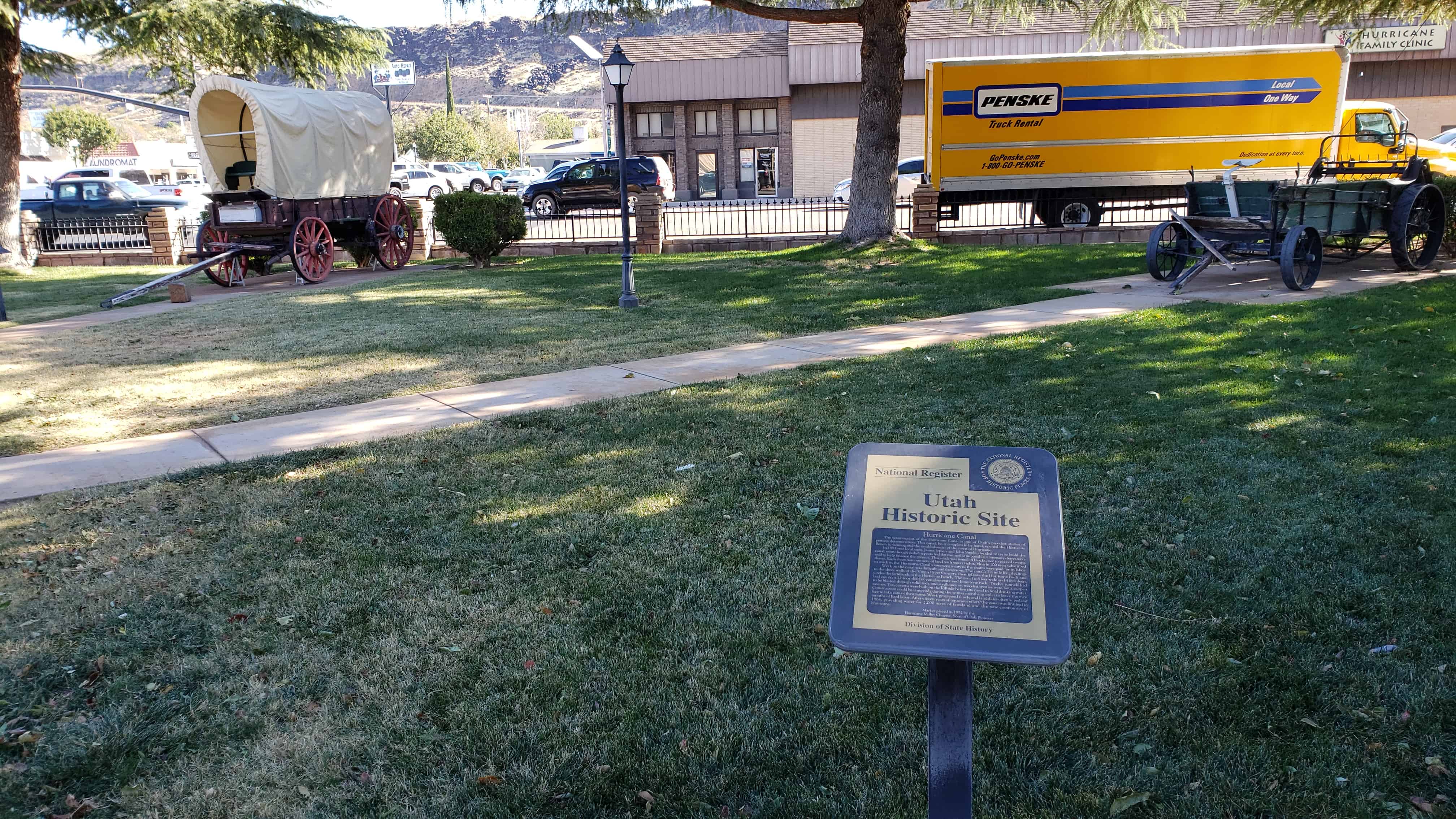
Studebaker, McCormick and Bain wagons were popular in Utah’s Dixie.
The white canvas covered wagons were used by Dixie Peddlers to haul Dixie Sorghum and Dixie Fruit and other farm products to mining and farming communities in the north. Then, trade goods were hauled back to Dixie.
Huge bags of wool were hauled in these wagons to the railroads for shipment to the markets in the East.
Freight wagons were used to haul freight from the railroad in Marysvale, York, Lund, Milford and Modena to the merchants in Dixie.
Several loads of juniper and pine wood were hauled from mountains and mesas to each home for use in their wood-burning cook stoves, fireplaces and heaters. Many young men, from twelve to eighteen years of age, hauled several loads of wood down steep, dangerous dugways each year.
This covered wagon was donated to the Heritage Park by Woodrow Jepson, a son of one of Hurricane’s founders.
Between June 9, 1856, and July 6, 1860, ten separate Handcart Companies left Iowa City, Iowa, or Florence, Nebraska to their land of Zion in the Utah Territory. There were 653 handcarts and 50 wagons.
Nearly 3,000 souls, some with babes in arms, and grandparents in their 70’s, pulled their worldly possessions and their fervent hopes across 1,400 miles of treeless prairie, lonely desert, icy rivers and rugged mountains. They came undaunted in their fragile two-wheeled carts, powered and fueled by muscle, unwavering faith and determination.
The first three and the last five of the handcart companies made the journey without suffering any unusual hardship or death, but the fourth company of 500 people, under the leadership of Captain James G. Willie and the fifth company of 576 people, under the leadership of Captain Edward Martin, suffered excruciating agony through hunger, fatigue, dysentery, and death.
“If raw courage and endurance make a story; if human kindness, helpfulness and brotherly love in the midst of raw horror and tragic suffering are worth recording, this never-to-be-forgotten episode of the Mormon Handcart migration is one of the great tales of the west and of America.” -Wm. Stenger
A Warning Unheeded
Upon returning from a four-year mission to Siam, India, Levi Savage, Jr. arrived in Iowa City, Iowa where the Willie and Martin handcart companies were preparing to leave for Salt Lake City. He was chosen as a sub-captain over 100 immigrants in the Willie company. These immigrants had started late from Liverpool, England and they were delayed in Iowa City while handcarts were constructed for them from unseasoned wood. They were delayed again in Florence, while they repaired the handcarts and made other last-minute preparations. Levi could see that they were far too late in the season to start across the plains to Salt Lake.
At a meeting in Florence, Levi tried to persuade the immigrants to stay in Florence until spring, but being naive and unacquainted with the hazards they would face, and anxious to reach Salt Lake, they voted him down.
Levi savage then said, “Brethren and Sisters, what I have said I know to be true; but seeing you are to go forward, I will go with you, will help you all I can, will work with you, and if necessary, will die with you; but you are going too late. May God in his mercy bless and preserve us.“
Tragedy Strikes
For most there was the joy of fulfillment, as they reached the Salt Lake Valley, to join others who had come by ox teams and covered wagons in earlier years. For the Willie and Martin companies there was heartbreaking tragedy. Caught in the grip of an early severe winter, in the Wyoming plains, they were brought to an ill-prepared delay in a fierce blizzard. Faced with deep snow, freezing weather and an exhausted food supply, they were forced to await a most heroic mass rescue the frontier had ever witnessed.
Handcarts West
Courage dared them rise And face each dawning day. Faith, it was their blanket As at the close of each they prayed. Courage got them moving As ever west they went. Faith kept them moving Their courage and strength long spent. And so with weary windworn hearts They reaped as they had sown. Faith and courage – tempered strong And from this land, a home. Built with courage, cemented in faith It would survive time’s sands. Then somewhere, somewhen, somewhy They placed it in our hands.
Rescue Parties Sent Out by Brigham Young
When word reached Brigham Young, during October Conference in Salt Lake City, he dismissed the General Conference and immediately called for volunteers. By the end of the week two-hundred-fifty wagons, loaded with food, clothing and bedding, were on the way to give relief and to bring these destitute souls to Zion. However, without food or shelter, a staggering toll of deaths occurred before help arrived.
Of these two companies, nearly 250 died of fatigue, disease and exposure. They were buried along the way in shallow graves. Some would have to have frozen limbs amputated, while others bore the scars of this arduous journey the rest of their lives.
A Scene to Remember
The desperate plight of these immigrants was recoreded by a traveler in these words.
“A condition of distress met my eyes that I never saw before or since. The train of handcarts was strung out for three or four miles. There were old men pulling and tugging carts, sometimes loaded with a sick wife or children; women pulling along sick husbands; little children struggling through the mud and snow. As night came on the mud would freeze to their clothes and feet. There was no fuel to burn, except wet sage brush, and their clothing and bedding now altogether insufficient to protect them from the bitter cold. Several who pulled handcarts by day would be placed in a mass grave the next morning.“
The leaders and members of the Willie and Martin handcart companies have left a glowing legacy of faith, tenacity, and integrity to innumerable stalwart descendants who helped colonize historic Utah’s Dixie and are included among its residents today.
Levi Savage, Jr. 1820-1910 “Let no man be afraid to lay down his life for my sake; for whoso layeth down his life for my sake will find it again.” Doctrine and Covenants 103:27
Levi savage, Jr. was born on March 23, 1820 in Greenfield, Huron County, Ohio. He was the second of 15 children born to his parents.
Levi joined the Mormon Battalion in 1846 and was part of its historic march through the southwest and on to San Diego.
Levi moved to Toquerville, Washington County, Utah in 1865 and lived there with his three wives and family for 45 years, until his death in 1910. He was laid to rest in the Toquerville Cemetery.
The Savage Crossing on the Rio Virgin
Levi Savage, Jr. owned farmland in Toquerville and La Verkin, Utah. Some time before Hurricane and La Verkin were colonized, Levi dug a ditch along the south side of the Rio Virgin and irrigated a farm about a quarter of a mile west of where La Verkin Creek and Ash Creek join the Rio Virgin.
The area that he used to cross the river became known as the “Savage Crossing.” Sheepmen and cattlemen used this crossing to take their wagons and herds to the Arizona Strip. They Honeymoon Trail branched at the foot of the Hurricane Cliffs and the west branch went to Washington and St. George, Utah and the north branch crossed the Rio Virgin at the Savage Crossing and ran north through Toquerville and on to Salt Lake City.
This Pioneer Handcart plaque and funds to help with the perpetual care of Heritage park were donated by the Levi Savage, Jr. descendants. The handcart illustration was drawn by Susan Savage, a great-granddaughter of Levi Savage, Jr. The poem, “Handcarts West” was written by Derek Naegle, a great-grandson.
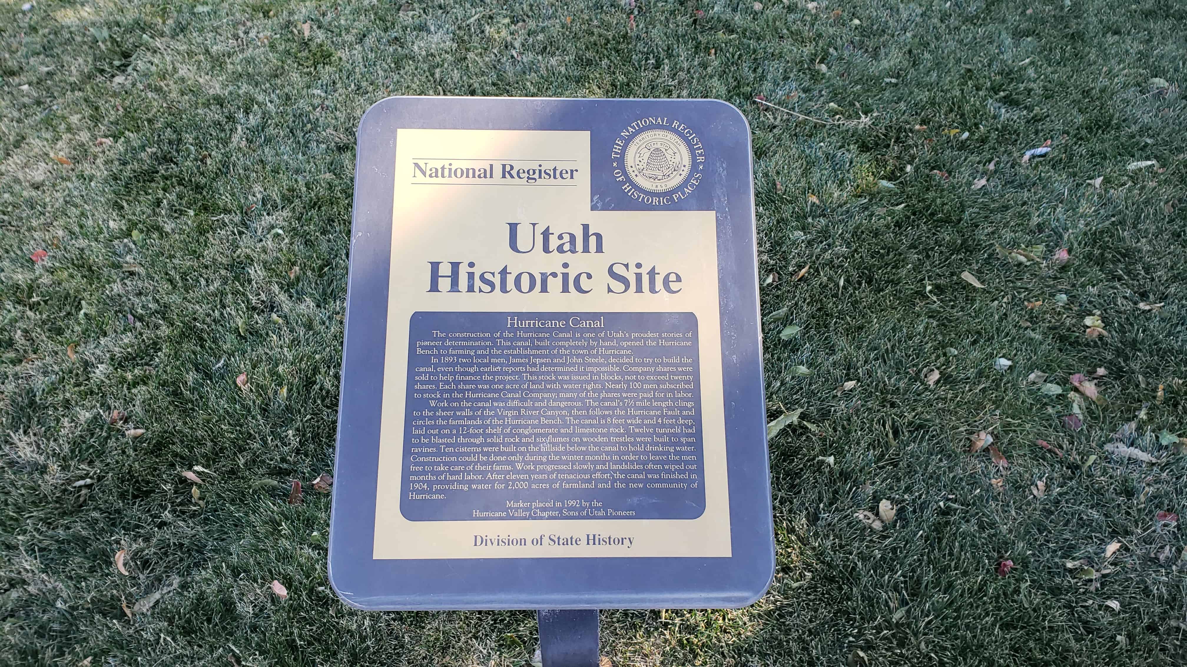
The construction of the Hurricane Canal is one of Utah’s proudest stories of pioneer determination. This canal, built completely by hand, opened the Hurricane Bench to farming and the establishment of the town of Hurricane.
In 1893 two local men, James Jepsen and John Steele, decided to try to build the canal, even though earlier reports had determined it impossible. Company shares were sold to help finance the project. This stock was issued in blocks, not to exceed twenty shares. Each share was one acre of land with water rights. Nearly 100 men subscribed to stock in the Hurricane Canal Company; many of the shares were paid for in labor.
Work on the canal was difficult and dangerous. The canal’s 7-1/2 mile length clings to the sheer walls of the Virgin River Canyon, then follows the Hurricane Fault and circles the farmlands of the Hurricane Bench. The canal is 8 feet wide and 4 feet deep, laid out on a 12-foot shelf of conglomerate and limestone rock. Twelve tunnels had to be blasted through solid rock and six flumes on wooden trestles were built to span ravines. Ten cisterns were built on the hillside below the canal to hold drinking water. Construction could be done only during the winter months in order to leave the men free to take care of their farms. Work progressed slowly and landslides often wiped out months of hard labor. After eleven years of tenacious effort, the canal was finished in 1904, providing water for 2,000 acres of farmland and the new community of Hurricane.
Marker placed in 1992 by the Hurricane Valley Chapter, Sons of Utah Pioneers
The warm, comfortable, productive climate in the sheltered valleys along the meandering Rio Virgin and its lower tributaries in Washington County became known as “Utah’s Dixie”.
The rugged pioneer colonizers and their descendants are known as “Dixieites” and the stalwart men and women who took hundreds of covered wagon loads of “Dixie Sorghum”, “Dixie Fruit”, “Dixie Wine”, nuts, dried fruit, figs, pomegranates, etc. northwards to sell and barter in communities as far north as Salt Lake City became known as “Dixie Peddlers!”.
Cotton was grown in “Utah’s Dixie” in the late 1800’s. Fruit crops matured three weeks earlier in “Utah’s Dixie” than similar crops in the Provo area.
The perservering Pioneers of the communities of “Utah’s Dixie” were constantly having their integrity honed by the heart-breaking hardships of adversity. These rare qualities of integrity have been carried throughout the world by leaders throughout the world by leaders who have their family roots in “Utah’s Dixie!”.
This 1924 photo shows the east side of Main Street in Cedar City. Wagons loaded with sacks of wool from Gould’s Shearing Corral, near Hurricane, are being taken to the railroad for shipment in Lund, Utah.
This historic plaque sponsored by the family of Verl and Margaret Sanders, owners of Sanders Construction, Inc., Henderson, Nevada, in honor of Verl’s parents, Moroni and Mildred “Millie” Zabriskie Sanders.
Moroni was born Oct. 18, 1903 in LaVerkin, Utah. He was the first boy born in this pioneer community and later served 16 years as City Mayor. He was also a Dixie Peddler.
Moroni and his brothers Bill and Ervil were Pioneer turkey growers and hatchery owners for many years in Utah’s Dixie. Moroni’s father and mother, William and Sara Amelia Wilson Sanders, were Dixie Peddlers and Dixie Sorghum makers and members of the first LaVerkin L.D.S. Ward organized June 23, 1904.
Moroni’s wife, “Millie”, was a talented musician and Grand Daughter of James C. Snow who owned Snowfield and was the first School Teacher in Bellevue, a prominent camping spot for Dixie Peddlers, at the south end of the Black Ridge.
The toughest, heartbreaking barrier to the colonization of “Utah’s Dixie” was the Black Ridge between New Harmony and Pintura, north of Toquerville, Utah.
A deep, rough, lava flow clogged the valley from the base of the towering Hurricane cliffs on the east, to the foothills of Pine Valley Mountain on the west.
The jolting rocks subjected the pioneer wagons, animals, and human tempers to a terrific strain. There were broken axles, broken wheels and fellies, broken kingbolts and run-off rims, to try the patience of the weary travelers who were forced to resort to their own ingenuity in making repairs, being miles away from any possible relief.
Apostle George A. Smith, for whom St. George was named, proclaimed this road to be “The most desperate piece of road that I have ever traveled in my life, the whole ground being covered for miles with stones, volcanic rock, cobbleheads – and in places deep sand.”
This old pioneer trail and Peter’s Leap Road, were both used until 1869, when the winding road was constructed along the east side of Ash Creek. Many Dixie peddlers and freighters traveled this road daily with wagons.
Peter’s Leap
Peter’s Leap, two and and one-half miles north of Pintura, was no doubt the worst part of the route that ignited Apostle Smith’s ire.
The road followed a long-used Indian Trail, crossed Leap Creek Canyon, a 165 foot gorge cut in lava rock, at a point approximately one and one-half miles west of where Leap Creek joins Ash Creek.
Peter Shirts, a Cedar City pioneer, inspired the name. Shirts was paid $300.00 by the Washington County Commission, to build a road along the old Indian Trail on the west edge of the Black Ridge.
When asked how wagons would get across the deep canyon that barred the way, he replied, “We’ll Leap It!” The 165-foot canyon-crossing became “Peter’s Leap.” The stream became “Leap Creek.”
The road leading into the gorge from the south could be built at a somewhat reasonable grade of 15 percent. Down the north face, however, the dugway grade was a dizzying 30 percent grade.
A sturdy windlass was erected on top of the north canyon wall. The wagons coming from the north were stopped here. The cargo was lashed securely to the wagon box. The teams were unhitched and led down the winding trail to the canyon bottom. Then the wagons were eased down the canyon wall. The teams were then hitched to the wagons and they were pulled out of the canyon, up a gradual slope through a break in the south canyon wall. The distance between the top of the north canyon wall to the point where the road leveled out on the south, was 1000 feet.
Freighters and peddlers coming from the south, unhitched their teams in the bottom of the canyon and the windlass pulled their loaded wagons up the face of the cliff.
In 1869, the Territorial Legislature appropriated $1000.00 to build a good surveyed road along the skirt of the Hurricane Cliffs, east of Ash Creek. This road was well-graded and wound in and out of the ravines. It was a single track, with turnouts to let traffic pass.
This road was used as a main route from Salt Lake City to Utah’s Dixie, and to California from 1869 to 1925.
In 1925, a two-lane graveled road was built over the Black Ridge. Many years later this road was replaced by Interstate 15.
Peter’s Leap Indian Cave
The early pioneers discovered an Indian Cave, near the top of the canyon wall, at Peter’s Leap. It is accessible from the south rim, by following a narrow trail down the face of the cliff to an opening over 100 feet above Leap Creek.
Early settlers found woven yucca sandals, arrowheads, spearpoints, bone awls and other items in the Cave, as well as deposits of bat dung or guano.
In January of 1858, a group of workers went to Peter’s Leap Cave and excavated the bat droppings. Nitrate was leached out and combined with sulfur and sagebrush ashes. The result was saltpeter, the main ingredient of old-fashioned gunpowder. Production cost: twenty-five cents per keg.
Sylvan was born in 1917 to Joseph and Ellen Wittwer, who were among the Early Settlers of this Valley. He graduated from Hurricane High School in 1935, from Utah State Agricultural College in 1939, received his Doctors Degree from the University of Missouri in 1943, and was Director of the Michigan State University Experiment Station from 1965 to 1983.
Sylvan is recognized as a world authority on Greenhouse Culture; has published books and scores of scientific papers in this field; and has been invited to participate in major food conferences all over the world.
He has served with distinction on the most prestigious national committees, appointed by the U.S. Congress, Secretary of Agriculture, and the National Academy of Science.
Probably no horticulturist in the past 50 years, has done as much to promote the cause of technological agriculture and agricultural research on a world-wide scale, than has Sylvan H. Wittwer. He has received countless world and national awards in the field of Agriculture. His fame and success has not altered his great dedication to God, church, and country. He is Patriarch, past Stake President and Bishop in Lansing Michigan L.D.S. Stake, and has actively served as a leader and supporter of the Boy Scouts of America.
We salute Sylvan as a noble native son with a rich heritage in Utah’s Dixie!
Kolob By Owen Sanders When lassitude tugs at your body And robs you of zest to exist Come with me to Kolob And walk through the mild morning mist.
Huddle at dawn on a hillside
And scan the green valley below;
Listen to snapping and crackle of twigs
And thumping of hooves on the go!
When shots re-echo at daybreak
Your pulse starts pounding anew
As you search to locate your quarry
And forget the breathtaking view.
Come back with me to Kolob It’s fun to be with you up there Sluff off the work-a-day worry In the sparkling, clear mountain air!
Kolob is a majestic jewel in an awesome setting of rare scenic charm. It is one mile higher than Hurricane City and can be reached in a few minutes by driving constantly upward from plateau to plateau through spellbinding beauty at every turn in the road.
Pioneers who colonized Toquerville, Virgin City and Grafton, also ranched on Kolob. They hobbled and milked scores of half-wild cows, fresh from the lush, green pastures of Kolob and the desert rangeland far below. From the milk and cream, they made many crocks and barrels of butter and zesty cheese which was then hauled by wagon down the steep mountain road and sold or traded to merchants in Cedar City, St. George and the mining towns of Silver Reef, Frisco, Newhouse, Pioche and Delemar.
From Kolob Peak, Zion Canyon can be seen far below and the St. George Temple is visible 50 miles away and one mile below. For over fifty years, a pole gate swung between two giant ponderosa pines in Black Canyon on the road to Kolob. Until this gate was opened, livestock could not drift from the lower range onto Upper Kolob. Sheer sandstone cliffs formed a high natural barrier.
From the West and South, several massive pinnacles jut out from Kolob and rise several thousand feet from their base like fabulous “Islands in the Sky.” Some of these have a surface area of several hundred acres. By fencing across a narrow neck of connecting land, cattle and sheep could be held on this land.
Descendants of Kolob ranchers helped colonize The City of Hurricane in 1906. Now, Their descendants have homes and cabins on these ranches. Visiting Kolob is an exhilarating and unforgettable experience!
This Plaque sponsored by James Allen Ballard and his wife Joan Webb Ballard In honor of their pioneer progenitors, the Ballard and Webb Families, Who helped colonize the city of Hurricane!
These three buildings were originally built on this town square.
1912 School
Used as school, seminary, church and Relief Society Building.
1917 School
Hurricane School – elementary through high school built in 1917.
Hurricane Church
L.D.S. Stake center built in 1937.
Heritage, by Owen Sanders
Some were weak in spirit
And had not faith to try;
Some were weak in body
And left the trail to die.
While those who trudged the dusty trails
And suffered grief and pain
Were destined by their efforts,
to gain eternal fame.
We who bask in glory
Of our distinguished past
Must know, that all this glory,
Without effort, cannot last.
Our pioneer names ring down the years
In leadership and zeal;
Let’s help them ring forevermore
A vibrant, valiant peal!
“For the Lord shall comfort Zion: he will comfort all her waste places; and he will make her wilderness like Eden, and her desert like the garden of the Lord; joy and gladness shall be found therein, thanksgiving, and the voice of melody“. – Isaiah 51:3
This is S.U.P. Marker #23-B, see other S.U.P. Markers here.
See Mollies Nipple–Climb Mollies Nipple By Owen Sanders
This pinnacle piercing the skyline On the crest of the Hurricane Cliffs Is a vivid, visible landmark That has sparked many frontier tiffs.
The playful pioneer naming the nipple Was lost in the annals of time But Mollies who winced at jabbing jests Survive in sparkling rhyme!
Breathtaking vistas of awesome charm Can be seen from the Nipples crest And silently vie with any view That is lauded throughout the West!
To clamber like goats to the Nipples Nib Takes vigor of muscle and wind And laggards with fleeting devotion Are left on the trail far behind!
The magic of mind to climb for the crown Is the goad for gaining a goal; Should your body grow weary from climbing Consider the gift to your soul!
Mollies Nipple as seen driving West from Zion National Park. It rises 400 ft. above the crest of the Hurricane Cliffs.
Mollies Nipple as seen entering Hurricane City and the Hurricane Valley from California. The historic Nipple rises 1353 feet above the fertile Hurricane Valley.
Mollies Nipple was given its historic name by pioneer colonizers of Toquerville, Virgin City, Grafton, Rockville, Springdale and other communities along the Rio Virgin. The unique symmetry of this visible Dixie landmark is protected from rapid erosion by a massive capstone of volcanic rock.
Indian throwing sticks for hunting small game, and hardwood fire tongs used to pick up hot stones from camp fires and drop them into pitch lined baskets for cooking purposes, were found in small caves at the base of the Hurricane Cliffs below Mollies Nipple.
Hundred of hikers have climbed to the crest of Mollies Nipple to view a vast circle of breath-taking, colorful, geologic and historic wonders, unmatched by any view in the world!
Pottery shards were found by hikers on top of this butte, indicating Indians likely used this landmark to send up smoke signals to hunting and seed gathering parties.