
BC – Boulder City Hillside Letters
One of the collection of Hillside Letters. This one above Boulder City, Nevada.

26 Monday May 2025
Posted in Uncategorized
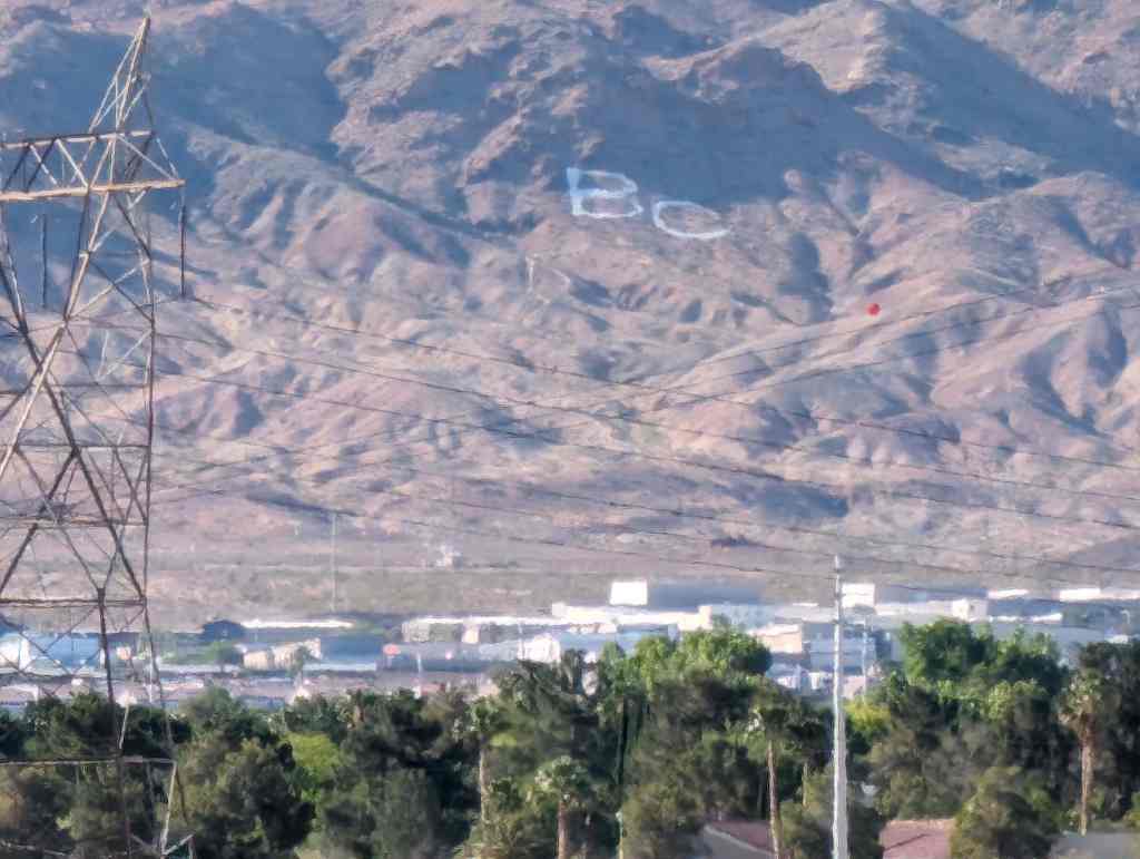
BC – Boulder City Hillside Letters
One of the collection of Hillside Letters. This one above Boulder City, Nevada.

27 Thursday Feb 2025
Posted in Uncategorized
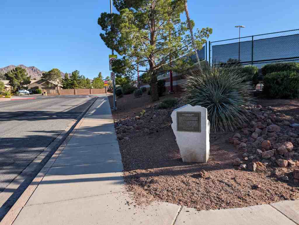
Arrowhead Trail – Henderson
The name, “Arrowhead Trail” likely originated from the former San Pedro, Los Angeles, and Salt Lake Railroad, which had an arrowhead for a logo. Prior to 1850, New Mexican trading caravans from Santa Fe en route to Los Angeles used this segment of the Old Spanish Trail.
Heading south along this trail toward Bishop Mountain, travelers turned through El Dorado pass, and continued to Nelson, Searchlight, Nipton, Wheaton Springs, and on to San Bernardino.
This section of the trail was popular as an early automobile road (1916-1924) connecting Salt Lake City and Los Angeles. Local communities along the route promoted its construction and the tourism possibilities of Southern Nevada, including the nearby Valley of Fire, Nevada’s first state park.

Nevada State Historic Marker #197, located at Mission Hills Park at Arrowhead Trail between Mission Drive and San Bruno Avenue in Henderson, Nevada.
27 Friday Dec 2024
Posted in Uncategorized
Tags
Hidden Forest Cabin
The Hidden Forest Cabin has been used for various purposes dating back to the early 1900’s. It is known to have been used by bootleggers during prohibition. According to legend the cabin was used as a robber’s hideout. The cabin was also used by prospectors and local ranching operations. The cabin was in fair condition when the Desert national Wildlife Range, then Desert Game Range, was initially staffed in 1938. An area just below the present site was initially, recommended for the refuge headquarters in April 1938. It has been used as an overnight shelter for refuge personnel since that date.
Hidden Forest Cabin is presently located within the proposed Desert Wilderness Area and the Hidden Forest Canyon is a popular area among refuge visitors.
Much of the history surrounding the cabin and the associated area is open to debate. Unsubstantiated stories and legends concerning the area have multiplied over th© past 20 years. Research could probably verify some history that has become exaggerated. This could be documented and utilized for interpretation of this unique cabin.
Hidden Forest Cabin is located north of Las Vegas, Nevada in Clark County at N 36.63132 W 115.20772 and was added to the National Historic Register (#75001106) on February 20, 1975. The text on this page is from the national register’s nomination form.
27 Friday Dec 2024
Posted in Uncategorized
Tags
Sheep Mountain Range Archeological District
Added to the National Historic Register (#74001145) on December 31, 1974.
27 Friday Dec 2024
Posted in Uncategorized
Tags
Tim Springs Petroglyphs
Added to the National Historic Register (#74001142) on December 16, 1974.
19 Thursday Dec 2024
Posted in Uncategorized
Tags
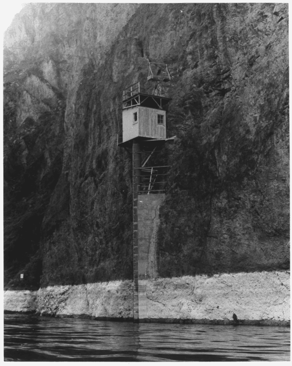
Willow Beach Gauging Station
From instagram:
The Willow Beach Gauging Station was constructed after the completion of Hoover Dam to provide data on Colorado River flow downstream of the dam.
The gauging station was constructed on the Nevada side of the river on the vertical wall in Black Canyon.
Originally consisting of two gauging stations and a bucket tramway system for access, this historic structure provides a glimpse of the past at Lake Mead National Recreation Area.
Please enjoy viewing the gauging station from the river, but not not climb or attempt to access the structure – it is both dangerous and could damage a historic structure.
The Willow Beach Gauging Station is located in Clark County, Nevada and was added to the National Register of Historic Places (#86000587) on March 21, 1986.
From the historic register’s nomination form:
The Willow Beach Gauging Station and its ancillary structures were erected to provide data on the flow of the Colorado River downstream from Boulder Dam after its completion in 1935, As such, the Willow Beach Gauging Station is a part of a complex of facilities which relate to the history of construction and operation of a nationally significant dam erected for flood control and irrigation purposes and, secondarily, to supply hydroelectric power. The Willow Beach Gauging Station contributed in its small way to the initial years of operation of this historic dam. It is also of local significance in engineering in its own right as reflected by its construction, hanging from the precipitous, vertical wall of the Black Canyon of the Colorado River, and its difficult access by cable tramway and catwalk hung from the canyon walls.
Reconnaissance to locate the site for a gauging station below the site of the new dam whose construction was just beginning was undertaken in 1931 by District Engineer W.E. Dickinson along with J.C. Hoyt, of the U.S. Geological Survey, and O.G. Patch, of the Bureau of Reclamation. Actual construction under the supervision of J.A. Baumgartner of the U.S. Geological Survey occurred in two phases, from January to July, 1934, and November 1934 to July 1935. Once completed, resident engineers at the gauging station were W.L. Heckler and W. E. Dail. The station operated until October 1939, when it was replaced by a new station closer to the dam (.8 mile downstream)
The Willow Beach Gauging Station, its cable tramway, and its catwalk and trail approach, are located in the steeps-walled Black Canyon of the Colorado River downstream from Boulder Dam, whose operation it served by measuring the flow of the Colorado River in the canyon below the dam. Originally the gauging station consisted of two gauging stations, both on the Nevada (west) side of the Colorado River, connected by bucket tramway cars hanging from cables across the river, which met on the Arizona side a combination of trail, catwalk hung from the wall of the canyon, and a third cable tramway across a side canyon, which extended southward along the Arizona side of the river to a residence and garage for the resident engineers. The residence and garage have been demolished, leaving only the terraced hillside with stone retaining walls on which they once stood. The lower gauging station and downstream tramway across the Colorado River also are gone. The remaining structures which are deemed to possess integrity, include the upstream gauging station, the cable tramway across the river from the gauging station to the trail, the trail along the Arizona side, the deteriorated but intact catwalk along the cliff, the trail south of the catwalk, the cable tramway across the side canyon on the Arizona side, the trail south of the catwalk to the residence site, and the stone retaining walls which mark the site of the residence and garage, which were approximately one and two thirds miles, as a crow flies, upstream from Willow Beach.
The gauging station itself consists of a small, square, shed-roofed metal room hung on a vertical cliff about forty to fifty feet above the surface of the river, whose level varies according to volume of flow. Beneath it, a corrugated pipe about four feet in diameter extends vertically from its floor into the water. The lower two thirds of the pipe above the water, and presumably all below, is connected not only to the cliff by metal supports, but shielded by solid concrete which prevents the water from passing between the pipe and the cliff and tearing it out. Above this concrete diverter, the gauging station is held to the cliff only by metal supports. The metal gauging room has three small £our-lite windows* one next to the cliff on its north side, one on the north or upstream edge of the side which faces across the river, and one on the canyon wall or western edge of the side which faces downstream. On the outer edge of the south wall is a doorway, and along the entire south side of the gauging room is a porch. From that porch, a metal ladder leads upstairs to a flat platform with railing, mounted several feet above the shed roof of the gauging room. Near the canyon wall, another platform is mounted 1 story below the gauging room porch, which allows transfer from a ladder which leads down from that porch to the main ladder which is mounted near the corrugated pipe, and leads down to near the surface of the water* The gauging station may be approached either by boat and ladder from below, or by cable tramway to the platform above. The tramway consists of a flat, shallow rectangular bucket hung by steel supports at each of its four corners from a pair of pulleys, one at each end, suspended from a single cable suspended across the river. From the east (Arizona) terminus of the cable tramway, a combination of trail along the edge of the cliff, a catwalk of wooden planks laid on steel supports driven into the cliff, with a railing of metal supports and metal cable along its outer edge, more trail, another cable tramway across a side canyon similar to the one described, and more trail, leads southward a distance slightly more than a mile to the site of the residence and garage, marked today only by concrete foundations and rubble retaining walls. The cable of a second tramway across the river to the second gauging facility (now gone), is still in place.
19 Thursday Dec 2024
Posted in Uncategorized
Tags
Mormon Well Spring was added to the National Historic Register (#74001143) on December 24, 1974. The text on this page is from the nomination form from when it was added.
The Mormon Well Spring site had been used by the Paiute Indians, a nomadic tribe of southern Nevada, for centuries before white explorers came into the region. The use of this site was seasonal. In the fall the Paiutes. came to the area to collect pine nuts and hunt bighorn sheep. They probably used the spring site as a base camp. Little is known about the use of the site by pre-Columbian cultures.
The spring is the only reliable water source for the surrounding vicinity. of the Desert National Wildlife Range. Therefore the area was used by the early travelers and prospectors during the late 1800’s and early 1900’s A Mr. John Thomas was the first white man to claim the spring’s water for a sawmill, but this project was abandoned before any development was done on the spring.
Beginning in the early 1900’s Mr. Joe Perkins, who then owned the Pickett Ranch in what is now part of the Moapa Indian Reservation, bought the water rights for the spring from Mr. Thomas and began grazing cattle and horses in the Mormon Well area. The cattle had to be moved often as the forage was scarce, but the horses did well and many horses were raised there. Over the years the spring was developed to provide more water for the livestock and the corral was constructed, but little was gained by the efforts.
In 1936 the area became part of the Desert Game Range and grazing was allowed but controlled by the U. S. Fish and Wildlife Service and the Bureau of Land Management. In 1966 the area was changed to a Wildlife Range under the sole jurisdiction of the Fish and Wildlife Service. At that time grazing was eliminated and the water became the sole right of the native wildlife again.
01 Sunday Dec 2024
Posted in Uncategorized
Tags
Corn Creek Campsite
Added to the National Historic Register (#75001105) on March 4, 1975.
27 Sunday Oct 2024
Posted in Uncategorized
Tags
Floyd Lamb State Park / Tule Springs Ranch
The subject project is an architectural/historic assessment and evalution of the architectural resources of the Floyd Lamb State Park. The Division of State Parks of the State of Nevada currently plans to develop the Park into a facility providing for greater intensity of public use, offering a variety of recreational activities. The report will also provide an assessment of the effects of the proposed park development upon existing resources.
The Park served as a city park for the City of Las Vegas from 1964 to 1971, as a private commercial entity from 1959 to 1964, and as a working ranch/guest ranch from 1941 to 1959, during which period most of the existing structures were built. The property possesses some historical values due to its uses during these periods as well as prior eras, and some architectural values due to the construction, planning, and design of the ranch complex.
The purpose of this report is to assess the architectural/historical significance of the park and its structures in order to provide a basis for the development of appropriate plans for new facilities and modifications of existing park structures or facilities,
Tule Springs Ranch was added to the National Register of Historic Places (#81000383) on September 23, 1981. It is now the site of Floyd Lamb Park in Las Vegas, Nevada.
The history of Tule Springs prior to its first permanent settlement includes its use by Indian tribes, early settlers, prospectors, and a transport company. Historic discussion will focus primarily on ownership eras that may involve the addition of structures to the property.
Ownership: (from first permanent settlement of site):
Tule Springs’ history apparently began as an occasional early watering place for Indians traveling back and forth between the desert and the mountains in pursuit of seasonal food sources. Although they utilized the spring at Tule it apparently was not as favored a location for their uses as spring at either Las Vegas or the Redrock area.
Tule Spring may next have been used by Mormons as a camping place on their way to obtain timber from the northeast for construction purposes, having €stablishe3 a settlement in the Las Vegas valley in 1855.
In the late 1860’s, a reconnaissance trip through the area by Lt. George Wheeler of the U.S. Army Corps of Engineers noted that Tule Springs was one of the stops on a road traveled by prospectors from Elko Nevada to Prescott, Arizona. Tule Springs was described as having good water but no wood or grazing.
In 1876 a man named Kiel built a sawmill near Las Vegas and an 1886 map shows a road leading to the sawmill past Tule Springs. Although there was some local traffic in the late 19th century and a few prospectors, the majority of travel in the area occurred on other roads that did not pass by Tule Springs.
By 1904, the imminent coming of the railroad assisted by mining discoveries in the Bullfrong region, provided a remarkable sudden population growth for Las Vegas. Tule Springs became a watering place on the Bullfrog stage route. A photograph, report, and a radio broadcast prepared by Charles P. Squires asserts that an establishment did exist at Tule by 1905, and was located just east of the main spring at Tule (possibly near the present swimming pool). The establishment appears to have been named the U.S. Hotel and was operated by a man known simply as Levandowski.
Squires discussed the freight road that passed by Tule at that time, where two or three freight outfits might be stopping at once with from 40 to 80 head of horses and mules in various corrals clustered about the Springs. An automobile stage line running past Tule from Las Vegas to the Bullfrog mine was also operating at that ‘time but ceased the following year when it was determined to replace it with a railroad line.
It is not known whether anyone lived at the Springs during the next 8-10 years or whether any structures existed on the property at that time.
The next individual known to have settled at the Springs was a Mormon, Bert Nay, who filed on the water rights in 1916. Nay’s application states that the property had never had any development work done on it. Apparently the U.S. Hotel, if it existed, had disappeared by then. The Nay family may only have spent summers at Tule Springs, living in tent houses and camping out of a wagon when following the stock.
The Ritenour report states that the smali adobe building (Building #13, Vhay & Ferrari Building Inventory) was probably built by Nay between 1914 and 1918, as a blacksmith shop and storage facility. Nay would have needed such a facility there on the ranch readily accessible for the care of stock.
However, according to the Nevadan, March 13, 1977 article, “The Nays return to Tule Springs”, Bert and Anne Nay actually lived in the old adobe building still standing at Tule Springs. The Georgia Lewis article states that “Indians or early traders built the adobe as a shelter and Bert added a roof, doors and windows. The adobe bricks came from large clay beds, later diked by Prosper Goumond in the 1940’s to form a lake.”
Nay also built a dam reservoir and apparently a small frame house near the Springs that apparently burned in the 1930’s.
Apparently the next owner of the property, Gilbert Hefner, was not responsible for the addition of any structures of the area. At this writing, after further conversation with Ms. Ritenour, the existence of a bootlegging operation on the ranch during Hefner’s ownership appears questionable. The Hefners did not develop the property further and it lay vacant until purchased in 1941 by the individual who sold it the same year to Prosper Goumond.
History: Goumond Era
By far the major portion of the Tule Spring Ranch, Floyd Lamb State Park complex was planned, developed and built by Prosper Goumond after his acquisition of the property in 1941. Goumond acquired the Tule Springs property on the day Pearl Harbor was attacked in 1941, and gradually added surrounding land until his total ownership involved 880 acres. Only two structures apparently remained on the property when Goumond purchased it, the adobe hut, and a deteriorated wooden structure, located at the end of the original entry between the Concessions Building and the Foreman’s House. He removed it when he began to develop the property.
The first structure built on the ranch by Goumond was the so-called Cook House, later known as the Club House. The structure ultimately experienced. several alterations but was originally built with 2 bedrooms, a fireplace, a living room and a kitchen. Its first addition was a large dining room to the east for ranch cowboys. This addition later became the kitchen, and a large guest dining room and bar were added to the southern part of the building. The bar had a decorative fireplace and yellow upholstery with a studded brass rail design, executed by Goumond’s grandaughter. This structure burned and was removed during the city’s ownership. A contemporary concession building, #15 of the Vhay/Ferrari Inventory, stands approximately at the former location of the Cook House.
The Cook House served as lodging while the other portions of the ranch were under construction. The next principal structure to be built was the Ranch House which became the residence of Goumound’s daughter, Pat Goumond De Vaney, Cliff De Vaney, and Pat’s daughter, Margo. (Prosper Goumond did not reside at the ranch, but lived in town.)
The original entrance road ran between Buildings #15 and #16, the Cook House and the Ranch House. The traditional square-framed “ranch” entry with gate and hanging signs marked the entrance to the ranch. The road that now extended east and west bet wen the stable row and the Hay Barn, and parallel to them, did not exist at that time.
The construction of the other ranch buildings took place on through the 1940’s. The initially rural residence rapidly evolved into a working ranch complex. At its height of operation, Goumond’s Tule Spring complex encompassed a considerable variety of ranch activities.
Goumond bred and raised a particular crossbreed of cattle termed “Brangus”, involving the mating of an Angus Bull and Brahma Heifer. Cattle were butchered on the ranch and hung in large walk-in butcher’s refrigerator. A concrete-walled enclosure in back of the Dairy Building, #6 in the Vhay/Ferrari Inventory, was fitted with a cement slab, built-in trough and a large wood framework with pulley for slaughter purposes. A network of corrals engulfed the area by the stable buildings.
The ranch also kept pigs. The hog house or pig pens and enclosures were located in Building #10 on the Vhay/Ferrari Inventory. Pigs were also slaughtered in the enclosure by the Dairy Building. The room at the west end of this structure held a butcher block table, stainless steel sinks, and various pieces of dairy machinery.
The ranch maintained a small dairy herd as well. Building #6, the Dairy Building, still contains the ramped concrete stanchions that held cows for milking by machine. A complex arrangement of pipe created stalls on a 3 1/2 foot tall concrete platform and held cows for milking by electric machine. (The process and its machinery were not always completely effective. The efficient modern procedure provided a display of intent sometimes followed by the actual milking of the cows down behind the barn.)
Hay and alfalfa for ranch livestock were stored in the large hay barn by the lake. The ranch cultivated and farmed alfalfa in acreage to the northeast of the lake and south east of the pool area thus providing fodder for its cattle.
Stock included horses, both working and ‘dude’, cattle, and dairy cows. Chickens were kept in Buildings #4 and #5, pigs in Building #10 and possibly Building #8, and turkeys were also raised on the ranch. Peacocks, and both domesticated and wild ducks and geese co-existed on the ranch. The water fowl populated both the pond spanned by the suspension bridge and the lake.
The lake itself was stocked by bass, crappie, and blue gill fish, and provided a setting for canoeing or boating. A boathouse, now gone, housed lake canoes and was fitted on the interior with a system for lifting them out of the water.
A swimming pool surrounded by a white picket fence stood near the suspension bridge and pond, also edged in white pickets. The pool was originally built as a reservoir. It was filled with sand to provide a children’s play area during the city’s ownership. A fenced horse pasture (for the better horses) lay below the pool to the east.
The original spring lies beneath the northeastern edge of the Duplex Building #19. A cistern still exists under its foundation. The gazebo sheltered a drinking foundation and a refrigerated unit containing ice.
A large wood water wheel spanned a small masonry lined channel that carried water from the Pump House. The Pump House, Building #18, stands over the first well drilled on the property by Goumond.
The Spring House, Building #26, was occupied by Margo Goumond, Prosper’s granddaughter. Other accommodations existed in the Cook House and Bunk House, but apparently were mainly occupied by employees of the ranch. Maid quarters were located in the water tower, which had apartments also in the rear addition and at the second floor level.
An orchard with a wide variety of fruit trees stood to the north of the Guest House, Building #17. A truck farm provided fresh produce for the ranch and its guests, Products of both were summer-canned and stored for year round ranch use in the root cellar.
Green laws stretched between picturesque green and white structures, pools and graceful willows, tall cottonwoods and fruit trees, creating a garden oasis that contrasted sharply with the dry surrounding land.
A large Fairbanks-Morse diesel engine served by diesel fuel stored in a large tank embedded in the earth next to the Generator Building, #24, provided power for the ranch until diesel fuel became too expensive, Goumond also built his own operating telephone and power lines.
Essentially, the ranch was planned and managed, to the greatest degree possible, as a self-sustaining unit, virtually in the middle of a desert.
An interesting adjunct to the basic ranch operation in the late forties and early fifties was its evolving additional function as a guest or “dude” ranch. While dude-ranching in the west has a history that extended back into the 19th century, a combination of legal changes in Nevada and changing societal attitudes towards marriage created a climate that rather suddenly popularized the state as a combination divorce and guest ranch destination for the entire country,
A notable factor in this phenomenon was the reduction of the residency requirement for divorce in Nevada to only six weeks, the shortest term of any state at that time. Accordingly, the guests that came to Tule Springs were predominately potential divorcees, often women from the east, wealthy, well educated, and “social”.
Some additional apartments were created in order to accommodate this function, notably Buildings #17 and #19. Guest capacity at the ranch could apparently range up to 10 or 12 persons depending on various factors. Additionally, the proprietor of guest/divorce facilities like Tule Springs played the important role of “witnessing” the continuity of residence of divorce-seeking guests, according to state law.
27 Sunday Oct 2024
Posted in Uncategorized
Tags

Floyd Lamb Park at Tule Springs
Floyd Lamb Park at Tule Springs is a park at the site of historic sites Tule Springs Ranch and Tule Springs Archeological Site. Also located there is the historic marker Tule Springs.
9200 Tule Springs Road in Las Vegas, Nevada
