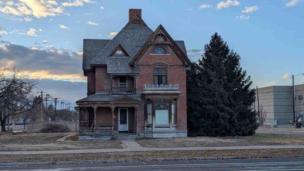
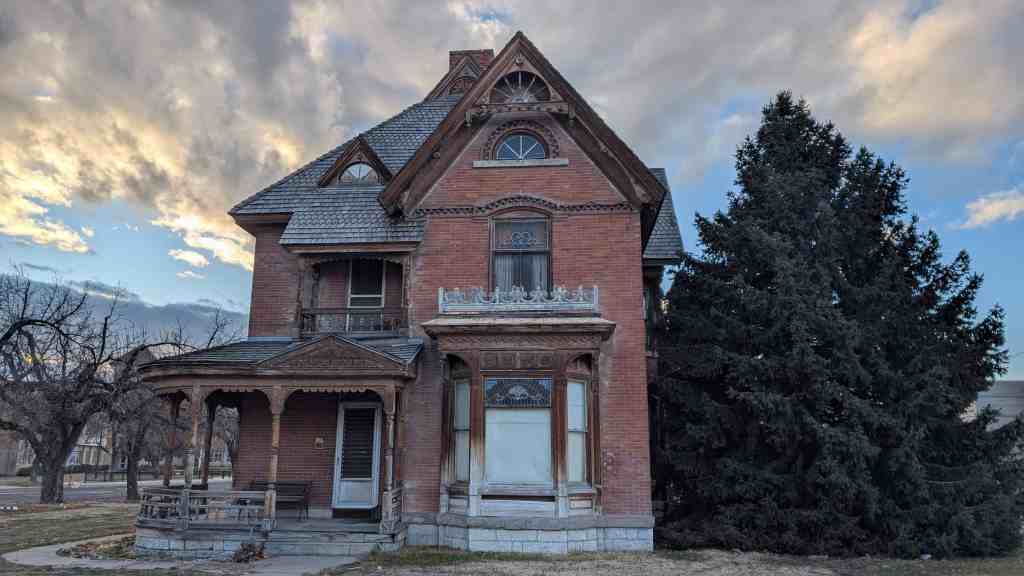
Fenn–Bullock House
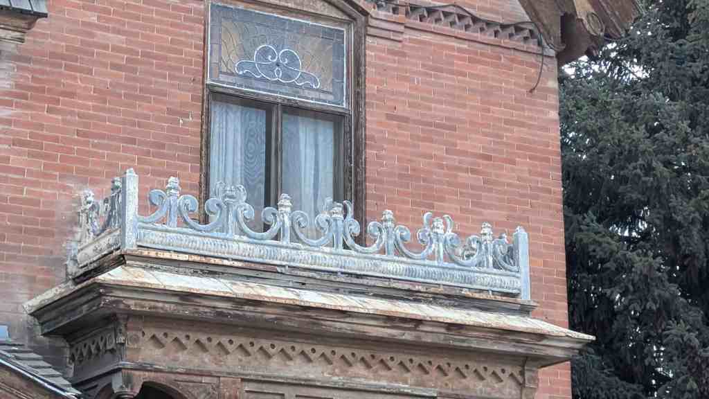
The Fenn/Bullock House, built c.1901, is significant under criterion C as an important, distinguishable architectural type in the city of Vernal, Utah. The house is side passage in plan, a type that is rare in Vernal, with only two other examples remaining. The side passage represented a progression from the vernacular Classical and the cross-wing house types as traditional building forms became increasingly influenced by popular types in the late 1800s. The Fenn/Bullock House stands out as probably the best and largest extant example of a “high-style” Victorian residence in the city. Most of the Vernal’s early buildings date from the turn of the century when the population became more established and began to increase in size, but this house is unique in Vernal. Although there are modest examples of Victorian architecture in the city, the size of this house, coupled with the side-passage plan, is quite uncommon. The intact historical integrity and the architectural attributes of the house allow it to be easily recognized and associated with the turn-of-the-century development of Vernal.
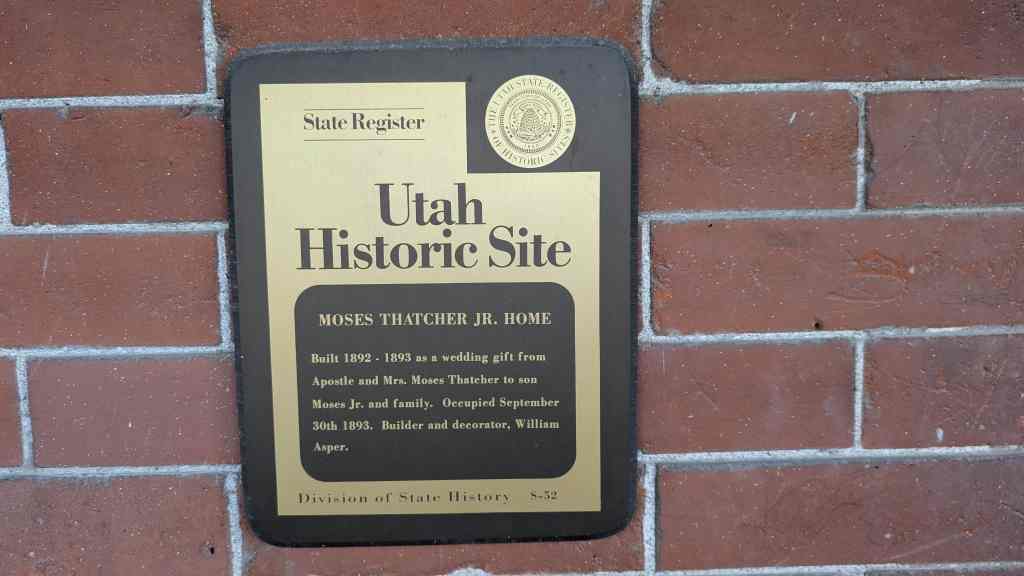
The Fenn–Bullock House is located at 388 West 100 North in Vernal, Utah and added to the National Register of Historic Places (#99000401) on March 25, 1999
The city of Vernal is located in the Ashley Valley, named in honor of William H. Ashley, an early trapper who entered the area in 1825. Located in the northeast corner of the state, and surrounded by various mountain ranges, the Ashley Valley was one of the last areas in the state to be settled. Brigham Young, president of the Church of Jesus Christ of Latter-day Saints (Mormon or LDS church), who directed the settlement of the Utah Territory, feared that the proposed Pony Express route through the Ashley Valley would bring settlers who were hostile to the LDS faith, so he sent a scouting party to survey the area in 1861. The report from the party was that “The area was one vast contiguity of waste, and measurably valueless, excepting for nomadic purposes, hunting grounds for Indians, and to hold the world together.” This report discouraged Young’s attempt to settle the area for the time being. But he was not the only one discouraged by the findings of the report, for the area was also rejected as a possible Pony Express route. Also in 1861, President Abraham Lincoln established the Uintah Indian Reservation south and west of Vernal, and placed Captain Pardon Dodds in charge as the agent. After his release in 1873, Dodds settled in the area northwest of present-day Vernal to raise cattle. What followed was typical frontier settlement, with trappers, prospectors, and drifters moving to and through the area.
Families began to move to the valley in 1878. Because of Indian/Anglo skirmishes in nearby Colorado, a fort was constructed in what became known as Ashley Center. After the fort was disassembled many settlers remained and a post office was requested, but because there was already a town named Ashley, the post office was assigned the name Vernal. Growth in Vernal was slow and somewhat uncoordinated. Settlement did not follow the typical pattern of development of most Mormon settlements in the state, where the town was laid out in grid fashion according to Joseph Smith’s “Plat of the City of Zion.” Later though, in 1884, the IDS church assisted in the organization of Vernal into a town, but actual incorporation did not occur until 1897. At this time the community began to slowly increase in population, as more businesses were established and houses constructed. The community was largely self-sufficient because of a lack of railroad access. And even when the Uintah Railway Company (a narrow gauge line mainly used for hauling gilsonite from the mines to the D&RGW railroad spur in Dragon, approximately forty miles to the southeast) was introduced in 1904, it was hardly sufficient to allow for much social or economic change in the area.
In July 1896, at a time when Vernal’s population and building were gaining a foothold, Lorenzo R. Fenn purchased the land on which the Fenn/Bullock house is located from A. J. Johnston for $150. Whether this was Lorenzo Richard Fenn, second child of Richard Ephraim and Sarah Grace Lewis Fenn5 , or another Lorenzo Fenn, is not known. Lorenzo Richard Fenn was born in Provo, Utah, on April 4, 1884, so he would have been twelve when he purchased the land. More than likely, it was another Lorenzo R. Fenn, possibly a relative, from whom Richard purchased the property in 1904. Richard Fenn and his family moved to the Uinta Basin in 1894, and the house was constructed c.1901 (the date provided in the tax file). Apparently, the father and son were both carpenters, and possibly built the house. Lorenzo is listed as a “single man” when he sold the property to Richard.
Richard was born in Provo on May 26, 1860, to William and Sarah Yarnell Fenn. After attending Provo city schools be became a carpenter. Among the projects on which he assisted were the Salt Lake LDS Temple, preparing it for dedication ceremonies in 1893, the Utah LDS Stake Tabernacle in Provo, and a school building in Vernal. In 1881 Richard married Sarah Lewis in Salt Lake City. His obituary states that he moved to Roosevelt, a community approximately 20 miles southwest of Vernal, in 1904.6 His history at this point is somewhat perplexing. Apparently, Sarah did not go to Vernal to live with Richard for the five children that Sarah had were listed as being born in Provo (including Lorenzo), Salt Lake City, and Alma, Wyoming. Sarah passed away in October 1892, in Salt Lake City, three weeks after her last child was born.
A family record lists another wife of Richard, Josephine Smith Hill, as living in Vernal where all of her eight children were born. According to the record she was married to Richard on the same day as Sarah, July 7,1881, but this is obviously incorrect since she was born in 1879, and would have been only two years old when married, (their official marriage date is not known). Apparently according to various items in the local newspaper, Richard was often in trouble for fighting, delinquent taxes, etc., and Josephine divorced him in 1914. She moved to Mackay, Idaho, after marrying John Thompson. Richard continued his carpentry work in Vernal and the surrounding area where various newspaper accounts show him residing in Vernal until 1918, when he moved to Cedar View, Utah. Richard then married again in 1921, to a Mrs. Maxfield in Salt Lake City. He sold the house in 1909, to John K. Bullock.
John Bullock was a prominent citizen of Vernal and probably the most famous owner of the house (the house is locally known as the Bullock House). He was born in Provo on June 9, 1861, to Kimball and Martha Bullock, and moved to the Ashley Valley in 1879 to ranch before settling in Vernal in 1895. John married Adelade “Addie” Burton in 1900. After moving to Vernal he continued to maintain a farm. In 1907 he became the treasurer for the Vernal Milling and Light Company flour mill. Perhaps John’s biggest accomplishment in Vernal, however, was his assistance in the organization of the Uintah State Bank in 1910. This was the second major bank in Vernal and was established as a result of prejudicial business practices of the officers of the first bank in the city, the Bank of Vernal.7 John was on the original board of directors and was the first treasurer of the bank. He was also active in civic affairs and belonged to many fraternal organizations, including the A. F. and M. of Provo, and the Vernal Lodge I.O.O.F. He also had the distinction of being the oldest living member of the Storey Lodge. At the time he purchased this house John was serving as mayor of Vernal; a position he held from 1908-09. It was during his term that electric lights were installed in the city. John and Addie had two children, but Addie passed away on February 19, 1923. Apparently, John remarried, for his obituary lists two stepchildren, but his second wife’s name is not provided. He continued to live in the house until August 1929, when he deeded the property to Isabrand and Mary Merkley Sander.
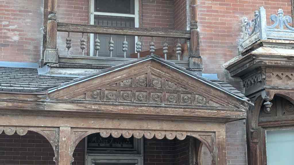
Little information is provided for the Sanders or other subsequent occupants. Isabrand managed the Vernal Drug and Golden Rule Store. It appears from the title that he and Mary owned the house from 1929-38 when they sold it to Herbert M. and Pearl Snyder. Again, little information is provided for the Snyders. According to an article in “Historic Sites and Homes of Uintah County” Herb was a Uintah County Sheriff for many years, and Pearl was a music teacher at Central School. In 1943, the property was sold to Harvey and Auleen Hullinger. Harvey was a principal in the Uintah School District. He was also a bishop for the LaPoint LDS Ward, and served four missions for the IDS church. The house remained in the Hullinger family’s ownership until 1970. The current owner, Vivian Gamble, ran an interior decorating business in the house, and then divided the building into a triplex. Currently, she is restoring the interior to its original plan for use as a single-family residence, and reversing many changes that have occurred over the years. Some of these changes include removing later walls that replaced doorways (see floor plan) and divided rooms, and stripping later coats of paint.
Vernal was settled much later and in a less organized manner than most of Utah’s communities. Because of the later settlement date, the early architecture of the town reflects both vernacular and the then-current Victorian styles. Victorian forms were popular in Utah 1885-1915, and the style of the Fenn/Bullock house represents the changes that were occurring in Utah at the turn of the century. The side-passage house type with Victorian Eclectic styling is important in symbolizing the end of Utah’s isolation in the late nineteenth century; although in communities such as Vernal the isolation would linger. Pattern-book styles and standardized building components were more available and easily adapted for use with local materials. The popular Picturesque and Victorian styles, as published in the pattern books, influenced and transformed the local traditional building forms so that the architecture obtained a regional and even national homogeneity. The quality of design and workmanship were also affected by technological developments during the Victorian era. The former isolation of Utah was no longer an obstacle to building well. Although there is not a lack of Victorian Eclectic-style buildings in the state, it is an important building style in Vernal because it was the first major style used at the time of the city’s establishment and early population influx during the last decade of the nineteenth century and the first decade of the twentieth century. In terms of numbers, after the 83 bungalows identified in the city, the Victorian Eclectic is the most common style for historic buildings, with 42 being recorded.
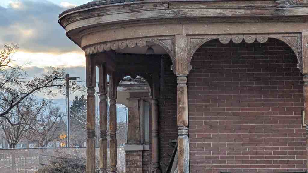
The most common floor plans for Victorian-era houses in Utah were the cross-wing, the central-block-with projecting-bays and the side-passage, all of which were very popular in the larger settlement areas. The side-passage plan consists of a rectangular block with the narrow, gable end facing the street and containing the main entrance. Like the central-block-type house, the side passage also contains projecting bay windows and wings, although it is slightly more symmetrical in design. The side-passage type originated with the Greek Revival temple-front house in the mid-nineteenth century. This type situated the gable end of the building toward the street as the main facade, with the entryway located to one side of the façade. Often, a cross wing would be added at the rear to make the house larger, with the main entrance opening to a passage that contained a stairway to the upper floor. When the Mormons migrated to Utah, the idea of the side-passage type came with them and was implemented in residential design, most commonly the Italianate and various Victorian styles.
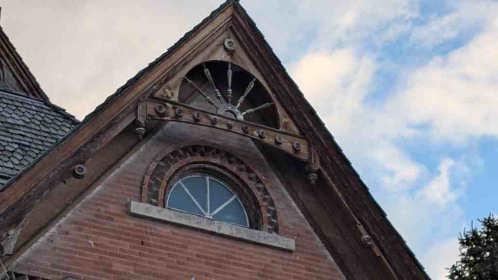
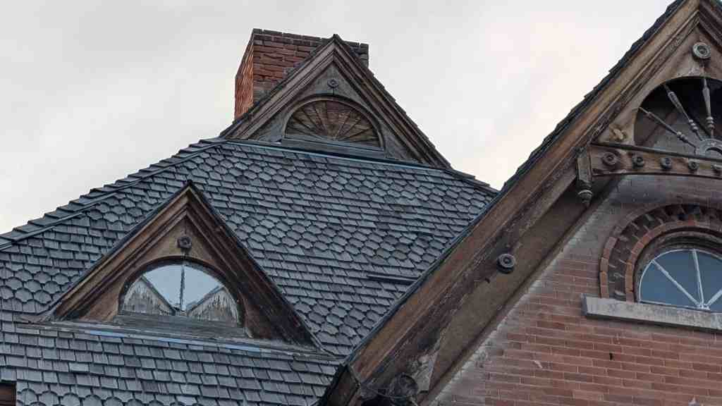
The progression from the temple-front side passage to the greater asymmetry of the Victorian version can be seen in the recessed front entry beneath a covered porch that usually wraps around from the front. The plan was further altered by receiving projections to many, if not all, of the facades, usually in the form of octagonal or box bays that allow for greater illumination of the interior. Add to these revisions steeply pitched gables and wood ornamentation, and the Victorian side passage little resembles its progenitor. While the more common cross-wing and central-block plans are found in ten houses each in Vernal, the side passage is found in only two buildings, including the Fenn/Bullock House, making this house even more unique in the community.
Unlike Vernal, most of the typical early Mormon settlements were established in an organized manner with the idea of permanence consciously wrought in the architectural fabric of the buildings. Because of their isolation, early settlers in Utah used indigenous materials in building construction. Stone was a common early building material. And, although brick was used where good quality, fire-grade clay was available, for practical purposes, unfired adobe bricks were more common in most areas of the territory because of the ease of manufacturing them. But, even if these materials in themselves lent an aura of permanence to the architecture, they were commonly disguised with a layer of stucco that was oftentimes scribed to appear as ashlar masonry, thus reinforcing the idea of permanence. The austere, Classical forms of architecture that were built during this period applied these permanent materials in such a way as to express artificiality and man’s control over nature.
The Victorian-era designers sought to change this tenet by expressing man’s relationship with, rather than control over, nature. They did this by using more-organic and less-rigid forms in housing design. Although brick was used, wood, because of its versatility, seemed to be the material of choice to accomplish this concept. From the 1870s on, buildings designed in the more expressive Victorian styles were becoming increasingly popular because of improvements in wood machining technology and also because of the introduction of the railroad to Utah which made available manufactured materials.
Of the earlier examples of building materials used in Vernal, wood siding, in its various forms, is by far the most common with 90 recorded examples (followed by stucco, 53, and brick, 41). Vernal’s location near the Uintah Mountains with their vast stands of coniferous trees meant that a large supply of wood was available for construction. Although the town was established during the Victorian era, not all of Vernal’s early architecture is strictly Victorian in style. In fact, most buildings are quite vernacular and follow more in the pattern of frontier settlements that implemented wood construction for the sake of expediency. The Fenn/Bullock House is unique, particularly in its remote setting, in that it represents the epitome of the Victorian architectural concepts, being probably the best extant example of a high-Victorian-style residence in Vernal that implements wood as the primary fabric to express the ideals of Victorian architecture.