Historic Resources of Springville City (from the National Register’s nomination form)
Early Settlement. Agricultural and Industrial Beginnings: 1850-1868
Springville City, in Utah County, Utah, was settled in September, 1850 by a company of pioneers of the Church of Jesus Christ of Latter-Day Saints (LDS or Mormon Church) led by Aaron Johnson. The colonizing families had crossed the plains during the summer as part of a train of 135 wagons captained by Johnson. Upon arriving in Utah, they were called by church leader Brigham Young to establish a permanent community on the banks of Hobble Creek, in Utah Valley. The suitability of the area for settlement and agriculture had been noted earlier by William Miller and James Mendenhall, who had traveled the length of Utah Valley during the winter of 1849.
The first community undertaking was the construction of a fortified compound in preparation for the coming winter. Encompassing about 1 1/2 acres, the fort consisted of log cabins arranged end-to-end so as to form the perimeter of a rectangular courtyard. All cabin windows and doors opened onto the secure central enclosure. During the winter of 1850-51, Aaron Johnson was appointed first bishop of Springville by Brigham Young. William Miller and Myron N. Crandall were appointed counselors. Johnson also was appointed District Judge of Utah County.
Through the 1850s, Springville established itself as a viable pioneer community. The spring of 1851 brought the beginnings of agricultural development in Springville. Farm plots were laid out and, through community effort, irrigation systems were quickly constructed to divert the waters of Hobble Creek onto the fields. Plat A of the city was surveyed, and home lots measuring 206.25 feet square were assigned to families by lottery. Allocations of irrigated crop land were restricted initially to 20 acres per family, owing to limitations on the availability of water from Hobble Creek. During these early years a number of new settlers came to Springville, augmenting the original population of Mormon colonists. The Springville city charter was approved by the Utah legislative assembly of 1852, and the first municipal election was held on April 4,1853. In this election, Gideon D. Wood was elected the first mayor of Springville.
Industrial and commercial enterprises during the pioneer period tended to be small in scale, locally-based, and oriented toward supplying the utilitarian essentials of the community. In Springville, as in other early settlements established by the LDS church in Utah, emphasis was placed upon cooperative efforts which ensured the viability of the community as a whole. Material luxuries and private monetary gain to a back seat (officially) to the good of the community during this period of Utah’s history.
The first significant industrial facility to be built in Springville appears to have been the Jacob Houtz flour mill, situated north of town on land now occupied by a fish hatchery. Constructed in 1851, it was the first flour mill constructed in Utah County. The structure was built by William Hall and James Potter (or Porter), using lumber cut at Hall’s sawmill from logs brought down Hobble Creek Canyon. The milling machinery was fabricated and installed by Norton Jacobs, who also served as the mill’s operator following its completion. The flour mill was subsequently purchased by Mr. Houtz, who remodeled the building c. 1865 and further upgraded it in 1885. In 1894 the mill was sold to Hatch and Riddle (or Liddel) Co., which demolished the original structure, replacing it with a “modern” brick building. The new mill operated until 1902, when it was destroyed by fire. The property on Spring Creek was subsequently sold to the Utah State government for use as a fish hatchery.
In 1865, Jacob Houtz, together with Jackson Stewart and William Bringhurst, were called by LDS church leaders to build a mill for processing cotton into cloth. Prior to development of the mill, spinning and weaving was a home-based industry — undertaken on an individual basis, typically by housewives, to provide for the immediate needs of family and the local community. The cotton mill was built on Spring Creek about one-half mile downstream from Houtz’s flour mill. Solomon D. Chase was contracted to build the two story frame structure. Milling machinery was installed by Norton Jacobs and James Straw. Mr. Straw also served as head weaver. A considerable freighting business developed around the mill, as raw cotton was hauled by wagon team from Utah’s Dixie to the factory, and processed cloth shipped out to various western destinations. Later, raw cotton was freighted in from St. Louis. In 1875, the cotton mill was outfitted with looms for weaving woolen cloth. Five years later the mill was sold to James Whitehead and the remaining cotton looms were replaced with additional equipment for processing and weaving wool. Springville Woolen Mills was then sold c.1905 to Charles Thorstensen, who remodeled and modernized the facility. Thorstensen operated the mill as Progress Spinning & Knitting Co., until it was destroyed by fire in 1915.
Sugar was a scarce luxury item during Utah’s early years of isolation. That shortage was alleviated by the construction of several small molasses mills in Springville during the 1850s and 1860s. In 1865, Newman Bulkley and Abraham Noe built a mill near Fourth South and Fourth East Streets. Like the flour and cotton mills of the time, Bulkley & Noe’s molasses mill was powered by water. A dam was installed on Hobble Creek near Sixth East and Sixth South. From here, a mill race diverted water to a large water wheel. The wheel turned the rollers that pressed the juice from the locally-grown sugar beets. Boilers then concentrated the juice into molasses, the sweet, syrupy liquid that was used as a substitute for refined sugar. During this pioneering period of self-sufficiency and cooperative community effort, molasses served as a commodity which could be bartered for other essentials. Local tradition holds that five gallons of Springville molasses were once traded at a Utah mine for over 2 1/2 tons of coal.
As was the case with these early industrial enterprises, Springville’s first mercantile businesses were small, local concerns. William J. Stewart is reported to have operated a store as early as 1852 in the original pioneer fort.
Henry H. Kearns also reportedly operated a store inside the fort at roughly the same time. George W. Johnson kept a store during the following year. Also in 1853, Gideon D. Wood and his son, Lyman, arrived in the city, opening a store on Second West and Second North. In 1856-57, Henry H. Kearns conducted a small dry goods business out of a house in Springville. One of the community’s most significant and enduring early mercantile establishments was that of N. H. Groesbeck. Upon settling in Springville in 1858, Mr. Groesbeck first opened a store in part of the old fort, then relocated his business to first South and Main Street. He continued in the dry goods business for a decade in Springville before selling out to the new co-op c. 1868.
Civic affairs of the pioneer period were carried out within the same framework of cooperative group effort that characterized other endeavors of the time. Community improvements such as irrigation systems, roads, bridges and public buildings generally were constructed by the citizens themselves, who contributed their own labor, materials, or support services to the projects. In 1853, a new county road was built between Provo and Payson, passing near the east bench of Springville. The following year, Springville pioneers turned out to raise a new, expanded fortification around the city plat. The “Big Wall”, as it was known, was built of mud and stood eight feet high, enclosing an area three quarters of a mile square. A number of log foot bridges were placed over Hobble Creek during the early years of settlement, but the first wagon bridge was not constructed until 1861.
The pioneer settlers brought with them a diversity of practical skills such as blacksmithing, carpentry, masonry and farming. Three brothers, John, Alex and William Nichols (known as the “adobe boys”) are said to have initiated the manufacture of adobe bricks in Springville. They built the community’s first adobe structure, a two-room house within the walls of the old fort. In 1856, adobes molded by Luke W. Gallup, Thomas Sprague and Newman Bulkley were used to construct the Big School House (later White Meeting House) which stood on the southeast corner of Main and Center Streets. Owing to the scarcity and high cost of other building materials, adobe was widely used in the construction of homes and public buildings during Springville’s pioneer period.
Public buildings served multiple purposes during the pioneer period, being used for church services, school classes, public meetings and social gatherings. Initially, such functions were held in the large adobe home of Bishop Aaron Johnson (built 1852, demolished 1940). A room in the Johnson home also served as a combination post office and tithing office. Later, the “Little Meeting House” served as the center for community affairs. Though built for use as a school house, the adobe building also served as a church, court room, dance hall and theater. The need for a larger facility soon became apparent, and in 1856 work commenced on the White Meeting House, built adjoining the Little Meeting House on the southeast corner of Main and Center Streets. It is said that every able bodied man and boy of Springville contributed either labor or materials to the project. The two-story adobe meeting house served the community needs of Springville for a half century before being razed in 1927.
By the close of the pioneer period, a chapel/school house had been erected in each of four Springville wards, the basic unit of LDS church organization. A telegraph office, established in 1867, gave the community a direct communication link to the rest of the nation.
As of 1867, the population of Springville stood at 2,000. The G. Owens business directory for that year contains the following compilation of Springville trades and businesses: five blacksmiths; five boot and shoe makers; one cabinet maker; five carpenters and builders (including Solomon D. Chase); one druggist; two grist mills (W.C. Penney; Storrs and Miller); one painter; one postmaster (Aaron Johnson); three saw mills; one syrup manufacturer (Buckley and Noah — possibly Noe?); two tanners; one wagon maker. Three establishments appear under the heading “Dry Goods, Groceries and General merchandise”: N.H. Groesbeck, southwest corner of Main and Huntington (First South); A.L. Lambson, Main Street; G.D. Wood & Co., Main between Rollins (Second South) and Huntington.
Industrial and Commercial Expansion: 1868-1915
The pioneering period of establishing Springville as a viable community was followed by an era of growth and diversification of industry and commerce. Promotion of the organized cooperative movement may have helped to initiate this new phase of development. The greatest impact, however, was brought by the railroad. Completion of the transcontinental rail line in 1869 ended Utah’s geographic isolation, linking the state to the products and markets of the entire nation.
The LDS Church’s cooperative economic system, adopted some years earlier by certain Utah communities, was significantly expanded during 1868. In that year, Zion’s Cooperative Mercantile Institution (Z.C.M.I.) was organized at Salt Lake City. The cooperative system had its basis in LDS church doctrine, and was encouraged by church leaders, most notably Lorenzo Snow. It espoused the principle of an independent, self-reliant society in which members would work for the common good rather than personal gain.
The Springville Co-op organization was headed by Bishop Aaron Johnson as president, with William M. Bromley as superintendent and C.D. Evans as secretary. Ownership was held by the citizens of Springville, some 300 of whom subscribed to stock in the institution when it was incorporated. Stock was issued in five dollar shares, with no one individual permitted to hold more than a $200 interest. Profits were disbursed among the shareholders as semi-annual or quarterly dividends. A Co-op mercantile store was set up in Springviile at Bishop Johnson’s school house, and N.H. Groesbeck was the first private merchant to sell out his stock of goods to the Co-op organization. Other Springville storekeepers quickly followed suit. About 1870 the Co-op store was moved to a small building on First West between Center and First South. This was later (c.1876) replaced by a larger store built by Solomon D. Chase on Main Street. This store was known as the Springville Cooperative Mercantile Institution. Another building, on North Main Street, was purchased by the Co-op from the Relief Society and became known as the North Co-op. The Springville Co-op also built a water-powered flour mill on First North Street between Main and First West. Constructed in 1876, the mill was operated and managed By George Storrs.
The early success of Springville’s cooperative system was destined to be short-lived, however. As was the case in other Utah communities, the cooperative ideal fell victim to increasing competition from private concerns and the reluctance of the cooperative’s members to participate fully in the communitarian system. One of the Co-op’s chief competitors was the mercantile store of Milan Packard, built on Main Street and First North in 1876 (Coinciding with the Co-op’s expansion into its Main Street store). Another major competitor cutting into the Co-op’s business was Henry T. Reynolds, Sr. He gained experience in the mercantile business working as a clerk in Milan Packard’s store. In 1881, Reynolds started a mercantile operation of his own, joining with his brother, Joseph, to form Reynolds Bros. & Co. In 1892, he built the 3-story H.T. Reynolds & Co. commercial block which still stands on the corner of Main Street and Second South. When built, it was the largest mercantile store south of Salt Lake City.
Some of the Co-op’s competitors gained their early business experience working for the cooperative itself. Such was the case with Romanzo and Theodore Deal, who left the Co-op to form Deal Brothers & Mendenhall Co. They built a large, brick general merchandise store in 1888, located on the east side of Main Street approximately one-quarter block south of Second South Street. Sanborn maps of Springville for 1890 show eight general stores situated along the length of Main Street. The Utah State Gazetteer for 1892-93 lists half a dozen-mercantile businesses operating in the city.
Many co-op employees bought failed co-op enterprises throughout Utah, in effect privatizing the LDS cooperative system. The failing Springville Co-operative Mercantile Institution was bought out by Gideon S. Wood in the mid-1890s and became a private concern. Mr. Wood previously was involved in railroad work and was employed as a telegraph Operator. He managed the G.S. Wood Mercantile Co. for more than 40 years, up to the time of his death in 1939.
The Springville Co-op Institution Flouring Mills on First North remained in operation into the 1890s.34 However, Sanborn maps show the building to be vacant as of 1898. By 1906, the mill was being run privately as Springville Flouring Mills. Sanborn maps for 1908 indicate that the mill had been converted to electric power and its production capacity increased. Later, c.1925, the business operated under the name Lillywhite Roller Mills. From 1876 until 1902 the First North mill likely endured some measure of competition from the Springville Milling Co. operation located to the north on Spring Creek.
Completion of the transcontinental railroad was an event which undoubtedly contributed to the demise of the cooperative system (which had been formally launched less than one year earlier). It also exerted strong influences upon the subsequent course of Springville’s history. The coast-to-coast transportation system ended Utah’s geographic isolation. It made goods from the outside more readily available, created new markets for Utah-produced commodities, stimulated commerce and the development of new industries, and brought in more settlers together with more outside influences. The pioneer period, with its emphasis upon basic essentials of community survival, self-sufficiency, and cooperative group effort, was brought to a final close.
Springville was uniquely affected by the coming of the railroad in two respects. Initially, building of the rail lines led to the city’s emergence as a major center for railroad construction contracting businesses. Later, with a network of routes in place, rail transportation became a chief factor influencing industrial development in and around Springville. The city enjoyed certain advantages with respect to transportation systems in that it was strategically located geographically. A short distance to the north was Salt Lake City and the major transcontinental rail link between the east and west coasts; to the east, through Spanish Fork Canyon, lay the extensive coal fields of Carbon County; to the south was a direct route to the ore deposits of Iron County and Los Angeles, beyond to the southwest.
number of Springville citizens gained their initial experience as railroad grade builders on the transcontinental railroad. Several thousand Utahns worked on grading crews for the Union Pacific and Central Pacific. Numerous camps from various Utah localities were set up along sections of the roadbed. Among these were the camps of Harvey Boys of Provo Valley, and Houtz & Wadaworth of Springville. Though many communities were represented in this early work, few emerged as enduring leaders in the business of railroad contracting. Springville rivaled Salt Lake City and Ogden as a contracting center, and at times totally dominated the field. The R.L. Polk & Co. Utah State Gazetteer for 1906-07 lists six grading contractors and six railroad contractors in the state, all of them working out of Springville. The 1911 Gazetteer lists fourteen grading contractors, again all in Springville.
Springville’s growth in this industry may be traced back to pre-raiiroad times, during which a number of men of the community worked as wagon team freighters. During the pioneer era Springville residents helped build, and later freighted over, a wagon road which ran up Hobble Creek Canyon to destinations 100 miles to the east. Early Springville freighters ranged east to the Missouri River, south and west to California, and north to Montana. Wagon freighting continued to be a profitable enterprise into the 1880s. The Culmer business directory for 1879-80 lists 24 freighting operations based in Springville. George McKenzie, Martin Crandall, Milan Packard, and members of the Bird, Deal, Palfreyman and Sumsion families all were freighters who subsequently moved into the business of railroad construction.
A branch line of the transcontinental railroad was extended south to Provo c. 1871-73, and later into Juab County, passing a mile west of Springville. In 1875, the Utah and Pleasant Valley Railroad was organized to provide a link to the rich coal fields discovered that year in Pleasant Valley, south of Soldier Summit. Principals in the new railroad included M.P. Crandall, Nephi Packard and Milan Packard of Springville, each of whom also held extensive interests in the Pleasant Valley mines.
The nearest junction with an existing rail head was along the Utah Southern route just west of Springville. In 1877 work began on a narrow gauge line down Spanish Fork Canyon, connecting the coal fields with Springville, Provo and the coal consuming markets. Though the principal construction contractor was an Ogden firm, many Springville citizens are reported to have been employed on the project. A sizeable portion of their pay came in the form of credit at Milan Packard’s mercantile store. The Utah and Pleasant Valley Railroad was completed to Springville in 1879 and extended to Provo the following year.
Thereafter the history of the Utah and Pleasant Valley Railroad became intertwined with that of the Denver & Rio Grande Western Railroad. Through the 1870s, the Union Pacific Railroad system had enjoyed a monopoly in Utah. Beginning in the early 1880s, the Denver & Rio Grande sought to challenge that monopoly by extending its routes westward. A period of intense competition ensued as the two companies vied to preempt one another on as yet unappropriated routes. The situation proved to be a boon to Springville contractors.
The Utah and Pleasant Valley Railroad was bought out by the Denver & Rio Grande in 1882 and became an integral part of the company’s Denver to Ogden branch. To the south, the Denver & Rio Grande extended a branch line from Thistle in Spanish Fork Canyon to Manti in 1890. The following year a separate corporation, the Sevier Valley Railway Co., was organized to extend the branch, which was completed to its terminus at Marysvale by 1900. This line was leased to and operated by the Denver & Rio Grande. Springville is said to have furnished many of the contractors who were involved with the construction of this line.
Another Denver & Rio Grande auxiliary corporation, the Tintic Range Railway Co., was organized in 1891 to build a branch line from Springville to the mines at Eureka. The main branch was completed in 1891, and 12 miles of spur lines constructed in 1892. It is likely that Springville contractors would have been closely involved with this project, given its location.
The Union Pacific system, meanwhile, was pursuing its own program of expansion. Work on the Utah Southern branch commenced about 1871, reaching Juab c.1879. Another segment, built c.1879-1880, extended the line to the mining district at Frisco. Construction of this Juab-Frisco section is reported to have been contracted to the Springville firms of Sumsion & Mason, Martin Crandall & Sons, and George McKenzie. Eventually, Union Pacific-controlled rails extended to the iron mines west of Cedar City, and on to Los Angeles in 1905.
The last major rail line to be built through Utah was the Western Pacific, a Denver & Rio Grande-controlled line built to compete with Union Pacific’s San Francisco route. Construction of the Western Pacific from Salt Lake City to San Francisco was underway between 1905 and 1910. The firm of Baxter, Straw and Storrs, principals of which included Nephi Straw and George A. Storrs of Springville, contracted to construct a long section of railway through the Feather River Canyon on the west slope of the Sierra Nevada. Baxter, Straw and Storrs built the historic, narrow-gauge Uintah Railway from Mack, Colorado over the Book Cliffs and Baxter Pass to the Uintah Basin gilsonite mines of Dragon, Watson and Rainbow, Utah.
Upgrading and double-tracking of existing lines, construction of additional spur lines, and maintenance work conducted in Utah and other western states continued to provide business to Springville railroad contractors through 1915 and beyond.
The railroads came at an opportune time for Springville, helping the community to diversify its economic base beyond the confines of agriculture. Even in the earliest days of settlement, it was known that the expansion of agricultural production in Springville ultimately would be restricted by the limited availability of water for irrigation. The contracting industry provided employment opportunities to large numbers of laborers and equipment operators. The railroads themselves offered employment in various operation and maintenance positions.
Nonetheless, agriculture remained a principal pursuit of Springville residents. Moreover, the community’s farm production, coupled with its proximity to rail transportation, made Springville a favorable location for agricultural processing plants. Two such facilities were built during the early I900s. Utah Sugar Co. selected a site south of the city for the first sugar beet cutting station to be built in the United States. Beets from Springville, Mapleton and Spanish Fork were sliced and pressed at the plant, and the extracted juice was transported via a 22-mile, five inch diameter pipeline to Lehi, where it was refined into sugar at the Utah Sugar Co. factory. Such plants had already been in use for some time in Europe, where networks of cutting stations pumped juice from the growing areas to central factories, thereby sparing farmers the task of hauling their beets long distances.
The Springville station went on line in the autumn of 1899. Shortly thereafter, additional stations were built at Spanish Fork, Provo and Bingham Junction, all feeding into the Lehi refinery. Initially, the system of auxiliary stations performed very well, and the Lehi factory became known as the most economically efficient sugar refinery in the nation. Over the longer term, however, the stations became a liability. After several years of operation, the pipelines developed leaks, resulting in increasingly heavy losses of beet juice despite daily maintenance patrols. This, coupled with other problems, led to the abandonment of the Springville, Provo and Bingham Junction cutting stations after perhaps a decade of use.
About 1905, the Springville Canning Co. was organized and a factory built next to the Denver & Rio Grande tracks west of Main Street between 1100 and 1200 South. Principals in the company were Myron E. Crandall, president, and Myron E. Crandall, Jr., vice president. The factory processed and canned fruits and vegetables, employing local labor. Business difficulties forced closure of the plant about 1958. The building still stands and currently houses racquetball courts.
The growth of commerce and industry in Springville between 1868 and 1915 was accompanied by a number of civic improvements. In 1880, the Springville City Hall building was erected in the center of the city square. Constructed under the direction of Lewis J. Whitney, Sr., the building was a two story structure of red brick on a foundation of native stone. It served the city for many years, but ultimately was demolished to make way for the present municipal building, c.1960. Expansion of the community’s school system was highlighted by establishment of the Hungerford Academy in 1887. Organized as a private school by the Presbyterian church, the academy provided high quality secondary and college preparatory education to many young people of Springviile and also attracted students from surrounding towns as well as from out of state. Two new public elementary schools, Jefferson and Lincoln Elementaries, were completed in 1905. Springville’s first public high school was built in 1909, following which the Hungerford Academy was gradually retired from use.
Establishment of a Presbyterian church in Springville in 1880 contributed to the religious diversity of the community. This was part of a larger, mostly unsuccessful, evangelical Protestant effort to convert Mormons to mainstream Christianity. By 1905, the Presbyterian, Baptist and Episcopalian faiths each had churches in Springville. The LDS church meanwhile had added a fifth ward.
Cultural activities were enhanced by the construction in 1882 of the Johnson Theater. Located at Main Street and Second South, the brick building held seating for 500 patrons. In 1891, Springville’s first formal banking institution was organized, and the Springville Banking Co. building was erected on the southwest corner of Main Street and Second South. 1891 also brought publication of the community’s first newspaper, the Springville Independent. The following year, a new passenger depot for the Denver & Rio Grande was built on Fourth West at Second South.
Shortly after the turn of the century, new public utilities made their appearance in Springville, helping set the stage for a modern, twentieth-century community. Telephone service was initiated in 1902 with establishment of the Springville Telephone Exchange. In 1903, the city installed its own electric light and power plant at the mouth of Hobble Creek Canyon.
By the early 1900s, Springville had grown to a city of approximately 3,500. The 1911 R.L Polk & Co. Directory shows Springville to have two banks, fourteen grading contractors, three hotels/rooming houses, one flour mill, one canning factory, and a municipal electric power plant. There were four general stores in operation: G.S. Wood Mercantile Co.; Deal Bros. & Mendenhall Co.; Packard Bros. & Co.; and IT. Reynolds & Co. Principals in the latter three firms also were prominent in the field of railroad contracting. Springville was served by two railroads: the Denver & Rio Grande western, and the San Pedro, Los Angeles & Salt Lake Railroad of the Union Pacific system. It is noteworthy that the 1911 directory also contains Springville’s first classified business listing of an automobile dealership (Studebaker).
Twentieth Century Developments: 1915-1940s
By the second decade of the twentieth century, the foundation had been set for Springville’s emergence as a modern city. Basic utilities and transportation systems were in place, and a reasonably broad and diversified base of commerce and industry had been established. The course of the community’s subsequent development was to be influenced by such factors as the regional proliferation of automobile and highway transportation, the introduction of heavy manufacturing industries in Utah County, and the industrial mobilization prompted by the needs of World War II.
As the building of the west’s railroad system was winding down, the automobile emerged, bringing with it a revolution in transportation. It was a natural progression that Springville should make the transition from railroad contracting to highway construction. The city quickly established itself as a center for highway contracting firms. By the early 1940s Springville was being touted by its Chamber of Commerce as having “more highway contractors per capita than any other city in America.”
Nonetheless, the railroads continued to exert major influences on Springville’s industrial development in the twentieth century. This was due to a fortuitous combination of circumstances: On the Denver & Rio Grande route through Carbon County lay deposits of high quality coking coal, a key component in metallurgical smelting and refining processes. On the Union Pacific route through southwestern Utah lay the iron ore deposits of the Iron Springs district. The two rail lines converged near Springville. With industrial water available from Utah Lake, the Springville-Provo area was ideally situated for steel production and related industries.
Springville’s traditional agricultural production continued through this period. The cannery described in the previous section remained in operation into the 1950s. For a time, an independent sugar refinery was in operation as well.
The automobile assumed a larger role in the United States in the twentieth century, eventually eclipsing the railroads as the primary means of transport for people and goods throughout the country. State and Federal highway programs, culminating in the Interstate Highway program in the 1950s and 60s, accelerated this trend. Railroad contractors found new opportunities in Highway construction. Among the contractors who made the transition from railroad to highway construction were Guy Mendenhall, H.T. Reynolds and William A. McKenzie. Guy Mendenhall was a son of Thomas Mendenhall and a nephew of Romanzo A. Deal. The latter two men were associated with the firm of Deal Bros. & Mendenhall, prominent in the Springville mercantile business and in railroad contracting. Both held high positions in Springville banking institutions as well. Guy Mendenhall began working with his father in railroad construction at age 13. He built a prominent career in railroad and later highway construction over many years. During the 1930s, Mendenhall was joined by his sons, Cornell and W. Deal Mendenhall, in the Guy Mendenhall Construction Co., specializing in highway work.
Henry T. Reynolds, Sr. was another Springville native who gained stature in the three disciplines of merchandising, construction contracting and banking. He headed the H.T. Reynolds & Co. mercantile store and served as president of Springville Banking Co. About 1915, he established the Reynolds-Ely Construction co. which initially contracted in railroad work, and later specialized in highway construction during the 1930s and through the end of the historic period. Henry T. Reynolds, Sr. was succeeded as president of the firm by his son, Harry T. Reynolds. William A. McKenzie held the position of vice president in Reynolds-Ely Construction Co. He came from a family of early freighters and well-known railroad contractors.
Wilford W. Clyde entered the road construction business in 1927. He had graduated from the University of Utah in 1913 with degrees in electrical and civil engineering, subsequently working in various engineering positions over the next 14 years. In 1933 he organized the W.W. Clyde Construction Co. together with two of his brothers. Headquartered in Springville, the company became one of the largest and most enduring heavy construction firms in Utah. During the 1930s, W.W. Clyde performed up to 25% of all road work done in Utah. The Company built hundreds of miles of highway in Utah and surrounding states, including large sections of the interstate system. In addition to highway building, W.W. Clyde was involved in such major projects as the Scofield Dam, Willard Bay dikes, the LDS church office building and Z.C.M.I. Center in Salt Lake City, and the Huntington power plant project. Wilford W. Clyde served as president and manager of the firm until about 1962, being succeeded in that position by his son, Cornell.
The steel industry also rose to prominence in the Springville area in the twentieth century. Deposits of iron ore were discovered at the Iron Springs district near Cedar City in southwestern Utah in 1852. However, early attempts to establish and operate iron works in Utah were unsuccessful. One factor which hindered successful production of iron in Utah was the fact that locally available coal from nearby fields did not yield coke of suitable quality for smelting operations.
It was not until 1921 that real development of Utah’s iron and steel industry began. In that year the Columbia Steel Corp., a Pacific coast enterprise, was organized for the purpose of manufacturing pig iron from Utah ores. After investigating various potential mill sites, the company selected a location, to be known as Ironton, about 4 miles north of Springville. Iron ore was transported to Ironton over the Union Pacific rails, while coal was brought in over the Denver & Rio Grande. The crude pig iron produced at the mill was transported by rail to Columbia’s west coast plants in California and Oregon for processing into various iron and steel products.
The Columbia works attracted satellite industries to Ironton. In 1923-24 the Republic Crusading Co. built a plant for processing coal tar (a byproduct of Columbia’s coke oven operations) into various flotation and creosote oils. In 1926 the Pacific States Cast Iron Pipe Co. established an iron pipe plant on the site. During the early 1930s the Ironton complex of industrial plants is reported to have generated annual payrolls of $1,500,000. Employment was provided to several hundred Springville and Provo residents.
The entire holdings of Columbia Steel Corporation were acquired by United States Steel Corp. in 1930. A subsidiary, the Columbia Steel Company, was subsequently set up as a subsidiary to operate these western U.S. facilities.
The onset of World War II vastly increased demand for steel at west coast shipyards. To meet these critical needs, the U.S. government contracted with United States Steel Corp. to build a large, modern, completely-integrated steel plant at a secure site in the west. The site selection process favored a location on Utah Lake just west of Orem, a few miles north of Provo. The government recognized Utah’s advantage of being one of only three states in the nation having commercial deposits of both iron and coking coal. Moreover, the Orem site was near a crossroads of transcontinental railroad lines, being roughly equidistant from Los Angeles, San Francisco, Portland and Seattle.
Construction of the new steel mill commenced in March, 1942, and was supervised by U.S. Steel’s subsidiary, Columbia Steel Co. In 1943, the Geneva Steel Co. was organized by U.S. Steel to operate all of the plant’s facilities. The Geneva Steel mill started production in the spring of 1944, and continued to be operated for the government until November, 1945. The end of the war brought a virtual shut-down of Geneva Steel. The government divested itself of the property, selling the plant to U.S. Steel Corp. In 1946, the Geneva plant and all Utah operations formerly managed by Columbia Steel Co. were organized under Geneva Steel Co.’s jurisdiction. Production facilities were expanded and upgraded over the next several years.
Prior to development of the Geneva mill, the combined operations of Columbia Steel Co., including the Ironton pig iron plant, iron mines, and coal mines had employed about 825 workers. By 1950, the combined operations of Geneva Steel Co. in Utah employed more than 6,000 people, with an annual payroll of $24,000,000. The Orem mill alone employed more than 4,000.
Production of pig iron and coke at the old Ironton mill continued through the 1950s. As of 1953, Ironton employed 600 workers and was producing 740 tons of pig iron and 800 tons of coke per day. The Ironton mill is no longer in operation. However, operations at Pacific States Cast Iron Pipe Co. have continued to the present day. R.L Polk & Co. directory records show Republic Creosoting Co. in operation at Ironton through c.1960, after which Republic appears to have been replaced or absorbed by the Reilly Tar Chemical Corp. (During the late 1950s, Republic and Reilly both shared the same P.O. Box address at Ironton.)
Geneva Steel became a major component of the post-war economy of Utah County, including Springville. In addition to directly employing many local residents, Geneva purchased many goods and services from Utah suppliers. The company also attracted a number of steel fabricating plants and other satellite industries to Utah Valley.
A third major industry in Springviile and the surrounding Utah Valley was the sugar industry. The SpringvilleMapleton Sugar Co. was one of many sugar refineries in the county. Built in 1918, the Springviile-Mapleton Sugar Co. refinery had been promoted by local beet farmers and businessmen, particularly Milan Packard. It was one of five independent factories to be built during and immediately after World War I in a region dominated by Utah-Idaho Sugar Co. operations. The war in Europe had curtailed production of beet sugar in France and Poland, resulting in a rise in world sugar prices. The price stimulus triggered rapid expansion of western U.S. production facilities during that period.
With a daily beet processing capacity of 350 tons, the Springville-Mapleton plant was small in comparison to other sugar refineries. Being situated in the midst of Utah-Idaho affiliated beet growing territory, the Springville-Mapleton operation never had sufficient producing farm acreage at its disposal to constitute an economically viable production unit. A controlling interest in Springville-Mapleton Sugar Co. was acquired in 1928 by Jones Investment Co., which then sold out to Utah-Idaho Sugar co. in 1932. Utah-Idaho operated the Springville refinery only for a single year (1933) during which it served 324 local beet growers. The following year, an explosion at the alcohol factory connected to the refinery did considerable damage to plant equipment. The Springville-Mapleton Sugar Co. refinery was subsequently dismantled in 1940.
A variety of civic improvements were undertaken in Springville during the period 1915-1950. They ranged from projects serving basic utilitarian purposes to endeavors intended to enhance the artistic and cultural environment of the community.
In 1920-22 a new city library was built with funds granted by the Carnegie Foundation.60 In 1924, the city water works system was upgraded, with old wooden mains being replaced with cast iron piping. The system was further improved in 1930 by the installation of a hydroelectric plant and modern water works at Spring Creek Canyon.
During the early 1930s a city street improvement project helped to provide work for those unemployed by the depression. The Art Deco-style Springville Memorial Hall was built in 1932 on the foundation of the old Opera House. New or remodeled chapels were built in several LDS wards during the early to mid-1930s.
In 1936, as part of the depression-era W.P.A. program, The Springville High School Art Gallery (later renamed the Springville Museum of Art) was constructed at 126 East 400 South, next to Springville High School (now demolished). The Spanish Colonial-style building is currently listed on the National Register. The year 1937 brought added improvements to public utilities with the installation of a sewer system and expansion of the city water works. A new post office building was constructed in 1941. In 1948, work was begun on a new and enlarged power plant project at Hobble Creek.
From its agrarian beginnings, Springville had grown to a thriving city of 7,000 by the close of the historic period in 1940s. Springville’s history over the preceding 100 years had been one of progressive growth accompanied by expansion and diversification of commerce and industry. Farming, livestock raising and fruit growing continued to be important components of the local economy, but various light and heavy industrial enterprises had established themselves as well. The city had gained a reputation as a center for the visual arts, and by the early 1940s was drawing an annual Springville Art Museum attendance of 35,000 to 50,000 visitors.
Residential Buildings
Description: Residential
Buildings According to a 1985 reconnaissance level survey, 99% of the sites surveyed are single family residences. Of these, 47% have retained their original fabric and are considered contributing to the historic resources of Springville, 2% have been altered and do not contribute to the city’s historic qualities, and 51% were constructed outside the historic period. Two percent of the residential buildings that remain are believed to have been constructed prior to 1868. The reconnaissance survey also shows that there are 62% remaining houses from the period 1868-1914 and 36% remaining from the period 1915-41. Of these buildings, there are approximately 60% Bungalow, 26% Victorian, 8% Period Revival, 4% Classical, and 2% Modern style houses. The majority of these houses are built of brick (60%), followed by wood frame with a various siding materials and stucco covered buildings (20% each), with few constructed with stone (1%).67 World War II and Post World War II era cottages constitute nearly half of the residential buildings constructed in Springville.
Phase 1:1850-1868
Springville’s pioneer period saw the establishment of a variety of residential, commercial, industrial, and institutional buildings in the community. However, a reconnaissance-level survey conducted in 1985 indicates that only residential structures have survived from that initial period to the present while also retaining sufficient architectural integrity to be potentially eligible for nomination to the National Register. Extant residential buildings of the pioneer period reflect the use of locally available construction materials of that time. Most are of locally manufactured adobe brick set upon foundations of native stone. A few frame dwellings are present, together with one or two rare examples of early log construction. Building types include single-cell, central passage, and hall-parlor houses, as well as some temple-form structures. The utilitarian emphasis of the time resulted in less highly stylized buildings than are found in later periods. However, vernacular expressions of Greek Revival stylistic influences are frequently exhibited.
Phase II: 1868-1914
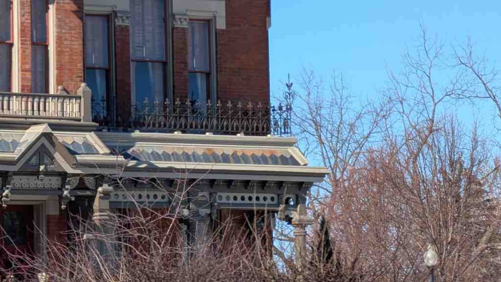
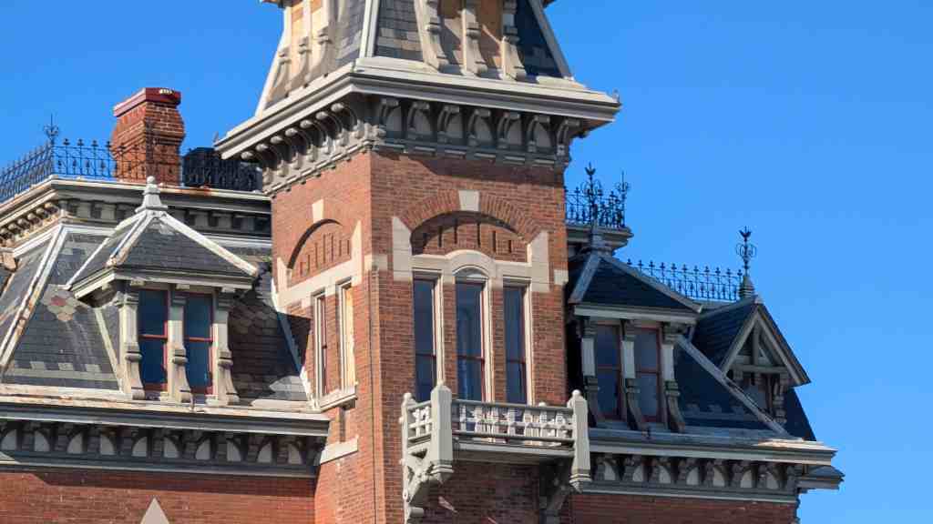
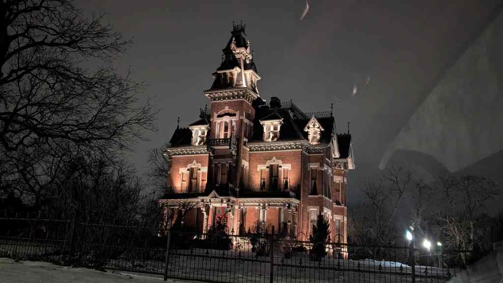
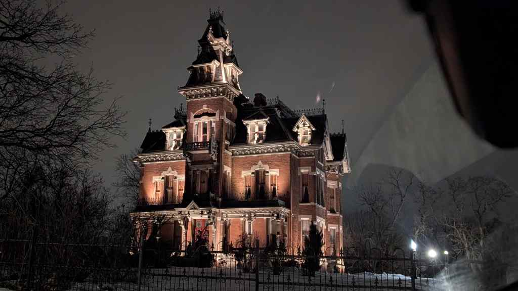
Many of the houses built during the second phase of Springville’s development (1868-1914) remain in good states of preservation. Brick, frame, and cut stone predominate as construction materials. Houses constructed during the early years of this period reflect Classical stylistic elements (e.g., Greek Revival) similar to those that characterized the pioneer period. During the 1880s, however, Victorian architecture was introduced in Utah. Victorian styles such as Queen Anne, Eastlake, Victorian Eclectic and Romanesque Revival became very popular in Springville, dominating construction in the community through the turn of the century. Residential building types of the period include hall-parlor and central passage during the early years, with cross-wing, Victorian cottage, and Victorian house types dominating the later years. The close of the period is contemporaneous with the appearance of the bungalow house type, reflecting Craftsman and Prairie stylistic elements. Toward the turn of the century, homes reflected the styles that were popular and spread throughout the nation via pattern books, and included Italianate, Victorian Eclectic and Queen Anne.
Phase III: 1915-1940S
Residential types and styles associated with the period 1915-1940s include bungalows in the Craftsman and Prairie, and other popular styles of the time, and period revival cottages and houses in a broad range of period revival styles, including Colonial Revival, English Tudor, and French Norman.70 Residential buildings of a type classified as World War II Cottages are now of sufficient age to be potentially eligible for National Register nomination. Although survey data on houses of the 1940s and early 1950s has not been compiled, a significant number of such homes are likely to be present in Springville. In the Brookside subdivision, 13 such homes are reported to have been built as a wartime project in 1944.
III. Significance: Residential Buildings
Residential architecture in Springvilie represents a continuation of broad patterns of American building traditions. The types and styles of the houses are generally typical of the country as a whole, but display a quality that is unique to Utah. The uniqueness of these residences is evident through the use of indigenous materials and the way in which the town grew, initially as an agricultural community, growing into a city that became associated with railroad and highway transportation. The phases of the town’s development with (1) farmsteads forming within the town grid, (2) the construction of permanent brick structures during the town’s expansion, and (3) the infill of primarily Bungalows and Period Cottages during the city development phase, combine to form a distinctive quality to the city. These patterns began with the influence of the LDS Church and have expanded through the combining of internal and external forces that directed Springviile’s growth. The town’s long association with railroad and highway construction provided exposure to influences from the entire country as Springville was more closely connected to these outside influences than many of the stronger Mormon, agricultural communities throughout Utah.
Phase 1:1850-1868
Residential buildings constructed during the first period of Springville’s growth (Phase I) are locally significant under Criterion A for their association with the earliest settlement phase of Springville. The patterns of settlement that essentially outlined the layout of the town are associated with and recognized through these early residences. They are also significant as material examples of the Mormon effort to create an ideal agricultural society. Springville was established like most Utah towns. Church leaders called upon members to explore and find areas in which agricultural communities could be established. Mills (flour, cotton, & sugar), mercantiles, and other industries were established to help support a self-sufficient lifestyle that was encouraged through Mormon settlement patterns. They are significant as material examples of the Mormon effort to create an ideal agricultural society. During this time, the city was settled and grew to prosperity as a viable Mormon pioneer community. The earliest homes in Springvilie reflect this typical Utah settlement and provide a document of its roots that connect it to other Mormon communities, even through the changes that occurred and shaped Springville to what it would become, a community known for its railroad and highway construction contractors. During this time, the city was settled and grew to prosperity as a viable Mormon pioneer community. Springville was based on agricultural self-sufficiency, like most Mormon settlements. The houses of this period reflect this emphasis. They are primarily utilitarian in character and appearance, and are built of locally available materials, such as adobe. Although the simple nature of these houses precluded many stylistic elements, Classical influences are apparent in such elements as symmetrical facades and cornices. The agrarian beginnings of Springville are important to remember and recognize as a foundation for its growth.
Those which are significant under Criterion C display the level of craftsmanship which was attained by builders in the local community. Other structures may also be significant under Criterion C for a good example of a plan or building type which is rare or diminishing in number in the area.
Phase II: 1869-1914
Later in Springville’s development (Phase II), larger, more elaborate houses were more prevalent. These buildings reflect the growing prosperity and sophistication that the arrival of the transcontinental railroad and other links to outside communities brought to Utah towns such as Springville. Not only did Springville’s citizens have the financial means to build larger, more stylish homes, they were more aware of the popular architectural styles through contact with the outside world. This trend continued through the historical period.
Residences built during 1869-1914 are historically significant for their association with the coming of the railroad, the early development of the city, and the agricultural expansion of the community. The hall-parlor house type with a rear lean-to or ell addition, remains a common form during this period. Cross-wing and central-block-with-projecting bays house types with Victorian stylistic influences begin to appear near the turn of the century, and describe the end of isolation in Utah with the accessibility of pattern book designs and the ability to purchase manufactured materials. In Springville, the brick Victorian homes with distinctive architectural features such as eyelid dormers, arched windows and doorways, and decorative brickwork, provide a distinctive quality to the Victorian house here and throughout Utah County. Although a local building company or contractor has not been identified, the stylistic features of many of these homes suggest a specific influence. Also, though the form is not isolated to Springville, it is confined primarily to Utah County. Many of these Victorian homes are seen in Springville and are associated with the individuals who were most involved with a town that was developing as the leader in railroad construction contractors. The mercantile businesses (late 1880s-90s) and the railroad contractors (1900s-10s), as well as agricultural processing plants, were the impetus for success that is reflected through the homes that they built.
Phase lll:1915-1940s
The prosperity of those developing industrial and commercial endeavors into continuing agricultural processing and highway construction during Phase III is reflected in the substantial brick, decorative buildings of that era. As the entrepreneurial transportation companies expanded to keep up with the nationwide highway growth, they continued what had begun in the railroad industry, succeeding in the latest transportation developments. As mercantile businesses reached their peak and manufacturing and industry coalesced into a small number of large entities, such as the Utah-Idaho Sugar Company and the Columbia Steel Corp., the working class expanded and WWII era cottages were built.
The Victorian house style gave way to the bungalow, America’s favored new middle class style. The bungalow became a popular house type in Utah in the years before World War I. The Arts and Crafts, Prairie School, and Bungalow styles were popular in Utah from 1905-25 and incorporated many similar stylistic features such as low, hipped roofs and wide, overhanging eaves. The wide porches helped to create an impression of informal living and unite the houses to their sites. The bungalow plan is open, informal, and economical and became the basic middleclass house, replacing the late-nineteenth century Victorian cottage. Like the Victorian style, the bungalow’s popularity can be attributed to the widespread use of architectural pattern books and a corresponding period of economic prosperity when many families were purchasing their first homes.
Period Revival English Cottages, English Tudor, and Colonial Revival homes were popular in Springville and throughout Utah primarily between 1920-40. A possible reason for the rise in popularity of the Period Revival style may have resulted from national pride following World War I which led to its increased use. English Tudor, Spanish Revival, and French Norman styles were most likely imported by soldiers returning from the war in Europe. These designs were based primarily on external decorative features rather than the historical building and planning traditions and “were simplistically massed, suggesting the informality that various architectural writers of the period stated was appropriate to the American way of life.”
During all three phases of residential development in Springville, many houses will also be significant under Criterion C, as important examples of specific types, styles, or construction techniques in Springville. Houses eligible for architectural significance can possess characteristics of a type, period, or method of construction; or they can show evidence of the work of a master designer, artist, or craftsman. Eligible early houses exhibit the spare, utilitarian stylistic characteristics of buildings typically constructed during this time. Later residential buildings will possess more elaborate stylistic elements of the Victorian styles. A shift toward simplicity will be evident in the houses built during the twentieth century, as the Arts and Crafts, Prairie and Period Revival styles became popular styles for houses in Springville. Eventually the World War II era cottage reflects the mass production and technological advancements of an increasingly industrial nation.
IV. Registration Requirements: Residential Buildings
The following criteria must be met in order for a property to be considered eligible under the residential property type:
- The building must be a domestic dwelling and have been constructed between 1847 and the 1940s.
- The original architectural features must be maintained to a great degree, though minor alterations are acceptable. Acceptable alterations might include the removal or covering of minor features, the painting of surfaces not originally painted, such as brick, and additions to the structure which appear sensitive to and distinguishable from the original construction. Unacceptable alterations could include replacement of original windows and doors with out-of-period styles; changes in size, number, or placement of exterior wall openings; alteration of exterior wall surfaces (e.g., aluminum siding); addition of roof dormers or skylights (particularly if on the facade); enclosure or removal of porches, or addition of out-of-period porches; and the presence of obtrusive or incompatible building additions/extensions. An important factor to be considered is the visual intrusiveness of any alterations, particularly with respect to the character of the primary facade. Elements which may be easily removed, such as aluminum window canopies, do not necessarily render a building ineligible.
- The original fenestration pattern and size of door and window openings on the principal facades must be maintained. The replacement of original windows and doors may be acceptable so long as they do not detract from the original historic qualities of the structure.
- In order for a building to eligible under Criterion C the building must be a good example of a particular type or style of architecture, or a good example of the work of significant local builders.
- Due to the relative scarcity of buildings dating from the pioneer period, the standards pertaining to architectural integrity may be somewhat less restrictive than those applicable to more recent contexts. Extant pioneer buildings show varying degrees of alteration. Virtually all of the adobe structures have, of necessity, had stucco applied to exterior walls; however, this would not in itself diminish eligibility. Given the large number of well-preserved examples of Victorian architecture present in Springville, the standards for integrity should be comparatively high when applied to buildings of this type. Surprisingly, reconnaissance survey results indicate significantly fewer potentially eligible twentieth century forms, as compared to late nineteenth century forms. It is possible, however, that this is a reflection of evaluation criteria employed by the surveyor, rather than an actual paucity of potentially eligible buildings from the 1915-1950 period. Despite this, standards for architectural integrity pertaining to residences from this period should be relatively strict for several reasons: Generally, the twentieth century styles tend to have suffered fewer and less significant alterations as compared to older building types. It is not uncommon, therefore, to find ample examples of sites which have retained very good integrity. Moreover, excellent representations of these styles are fairly widespread throughout Utah, and are particularly abundant in the larger cities.
I. Name of Property Type: Commercial
II. Description: Commercial Buildings
The 1985 Reconnaissance Survey of Springville identified no commercial or industrial buildings from the earliest period in Springville that have retained a sufficient amount of integrity to be eligible for listing. A great deal of commercial construction took place in Springville during the late nineteenth and eariy twentieth centuries. In contrast to the earliest commercial structures, many of these structures remain in good states of preservation. As with residences, Victorian building styles were often used in commercial buildings in Springville, most noticeably in a number of Main Street commercial blocks. Victorian Eclectic and Romanesque Revival features are most common on commercial buildings of the period. As tastes in building styles changed after about 1915, commercial buildings were built in such styles as English Tudor Revival, Spanish Colonial Revival, and Art Deco. Immediately after World War II, commercial buildings were commonly built in the simpler international style. Due to their utilitarian character, industrial buildings will have very little ornamentation in comparison to commercial buildings of the same period.
III. Significance: Commercial Buildings
Approximately one dozen commercial structures eligible for listing in the National Register have been identified. The size, complexity, and level of style of commercial and industrial buildings in Springville closely parallels the economic development of the town, and thus will be significant under Criterion A for this association. The changes that Springville underwent with the arrival of the railroad in Utah and the success of Springville railroad contractors are major trends associated with the city’s commercial and industrial buildings. In the twentieth century, the iron industry, agricultural processing industries, and highway contracting industries have risen to economic prominence. Significant commercial and industrial buildings from this time will likewise be associated with these economic trends. While the residential buildings of Springville also reflect the increasing wealth amassed through the various economic endeavors, the commercial structures illustrate the connection of the success of Springville citizens to the mercantile or retail stores that were built to supply residents with the goods and services they could afford, as well as the office structures that were needed to house the executives of the transportation and manufacturing businesses.
There are commercial buildings in Springville potentially eligible under Criterion C, for architectural significance.
Buildings eligible under this criterion embody the distinctive characteristics of a type, period, or method of construction, or they represent the work of a master, or that possess high artistic values, or they represent a significant and distinguishable entity whose components may lack individual distinction. The building form, architectural style, engineering technique, or artistic values, based on a state of physical development, or the use of a material or method of construction that shaped the historic identity of an area, must be present for the building to be eligible under Criterion C.
IV. Registration requirements: Commercial Buildings
The following criteria must be met in order for a property to be included as an eligible property under the commercial building property type:
- The property must be a commercial building and have been constructed during one of the three historical contexts outlined in this document: Phase 1,1850-1868; Phase II, 1868-1915; Phase 1,1915-1940s.
- The property must be associated with the history and development of Springville during one of the above noted contexts and have relevance and importance in illustrating a contribution to Springville’s development
- The original architectural features must be maintained to a great degree, though minor alterations are acceptable. Removal or alteration of stylistic features, or the addition of incompatible features generally would render a building ineligible for nomination. Unacceptable alterations could include replacement of original windows and doors with out-of-period styles; changes in size, number, or placement of exterior wall openings; alteration of exterior wall surfaces (e.g., aluminum siding); addition of roof dormers or skylights (particularly if on the facade); enclosure or removal of storefronts; and the presence of obtrusive or incompatible building additions/extensions. An important factor to be considered is the visual intrusiveness of any alterations, particularly with respect to the character of the primary facade. Acceptable alterations might include the removal or covering of minor features, the painting of surfaces not originally painted, such as brick, and additions to the structure which are sensitive to, sympathetic with, and distinguishable from the original construction. Elements which may be easily removed, such as aluminum window canopies, do not necessarily render a building ineligible.
- The original fenestration and size of door and window openings must be maintained. The replacement of original doors and windows may be acceptable as long as they are sensitive to the originals.
- Two-part commercial buildings which have been altered, but maintain a storefront appearance on the street level, may be eligible as long as the areas above street level remain intact and retain their architectural integrity. Overall, however, the building must have maintained the majority of its features that illustrate its style in terms of the massing, spatial relationships, proportion, pattern of windows and doors, texture of materials, and ornamentation.
I. Name of Property Type: Institutional Buildings
II. Description: Institutional Buildings
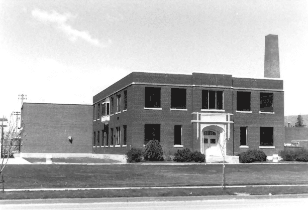
This property type includes Springville’s educational, religious, and public buildings. These institutional buildings have been the primary target for demolition throughout Springville’s history. The most significant early institutional buildings were demolished and replaced by new buildings by 1945. These included the first City Hall, the “White” IDS Meeting House, and the Bishop Johnson House (the site of many early city functions). Recently, there has been a raised awareness of the importance of Springville’s surviving landmarks. A number of institutional buildings have already been listed on the National Register as part of this effort. These include the Springville Presbyterian Church, the Springville High School Art Gallery and Mechanical Arts Building, the Springville Carnegie Library, and the Springville Main Post Office. Several historic buildings remain unlisted, however, including a number of Springville’s LDS ward houses, Springville’s historic school buildings, and the Springville Recreation Hall.
III. Significance: Institutional Buildings
Institutional buildings are by their very nature the center of a community. The rites of passage of a person’s life, such as ceremonies marking birth, marriage, and death are most often conducted in religious or civic buildings. Community affairs are conducted in government buildings, and a community’s children are schooled in educational buildings. In Springville, a community art gallery has been an important institution since the beginning of the twentieth century. All of the development phases of Springville can be closely associated with institutional buildings. Not all of these buildings survive, but those that do are significant under Criterion A for their association with civic, cultural, and religious affairs in Springville throughout its development. Most often these buildings will be locally significant, but some buildings may be significant in the broader patterns of State history.
Additionally, institutional buildings are often important architectural landmarks. Because of their high profile in a community, a great deal of attention is given to their design and construction. Surviving institutional buildings in Springville are designed in such popular styles as Gothic revival, classical revival, WPA Modeme, and several period revival styles. These buildings were often the work of noted Utah architects and craftsmen. Eligible institutional buildings may be significant under Criterion C if they fit the preceding description.
During this period of city development, cultural influences that were introduced from outside Utah because of Springville’s connection to not only other Utah communities for coal and iron ore, but also to California as a link to these Utah communities, the influences are seen in the civic development, such as the Springvilie Art Museum, and in the religious diversification. Although Mormonism remained a strong foundation for many Springville residents, many Protestant religions were established.
IV. Registration Requirements: Institutional Buildings
The following criteria must be met in order for a property to be included as an eligible property under the institutional building property type:
- The property must be an institutional building and have been constructed during one of the three historical contexts outlined in this document: Phase 1, 1850-1868; Phase II, 1868-1915; Phase 1, 1915-1940s.
- The property must be associated with the history and development of Springville during one of the above noted contexts.
- The original architectural features must be maintained to a great degree, though minor alterations are acceptable. Removal or alteration of stylistic features, or the addition of incompatible features generally would render a building ineligible for nomination. Unacceptable alterations could include replacement of original windows and doors with out-of-period styles; changes in size, number, or placement of exterior wall openings; alteration of exterior wall surfaces (e.g., aluminum siding); addition of roof dormers or skylights (particularly if on the facade); enclosure or removal of porches, or addition of out-of-period porches; and the presence of obtrusive or incompatible building additions/extensions. An important factor to be considered is the visual intrusiveness of any alterations, particularly with respect to the character of the primary facade. Acceptable alterations might include the removal or covering of minor features, the painting of surfaces not originally painted, such as brick, and additions to the structure which are sensitive to, sympathetic with, and distinguishable from the original construction. Elements which may be easily removed, such as aluminum window canopies, do not necessarily render a building ineligible.
- The original fenestration and size of door and window openings must be maintained. The replacement of original doors and windows may be acceptable as long as they are sensitive to the originals.