Standing here you are standing on a limestone layer of the Carmel formation, which formed in an ancient inland sea. The is was sea that covered the giant sand dunes that eventually turned to massive deposits of Navajo Sandstone. The formation is prevalent across the Colorado Plateau. Here at the San Rafael Swell, erosion has cut the Navajo Sandstone into great white monoliths, knobs, and canyons bearing names such as Ghost Rock, Locomotive Point, Joe and his Dog, Eagle Canyon, and Temple Mountain. A good eye can see how the rock layers dip slightly to the west. Eventually the monoliths will become knobs, the knobs will become mounds, and the mounds will succumb to erosion and disappear. The great cliff you now stand atop will also be worn away a grain at a time and “the hills will be made low.”
Stay and Play
From here you may choose to take the Moore Road to SR-10 and the communities of Castle Valley, which are excellent staging areas for a visit to the San Rafael Swell. The Wedge Overlook, the Swinging Bridge, the Cleveland Lloyd Dinosaur Quarry, and Coal Wash are favorite attractions. With some time and planning, you can have a lot of fun hiking, biking, four-wheeling, and horseback riding in the Swell. But without a guide or a good map, it can be a deadly place. If you do go into the Swell on your own, you are advised to have an accurate map, plenty of water, gasoline, and some food. Tell someone exactly where you are going and stay on trails and roads.
Four Brothers
Only the most daring cowboys inhabited the San Rafael Swell and the most notorious of them all were the Swaseys. Landmarks throughout the Swell bearthe names of the four brothers, Charlie, Sid, Rod and Joe. From here you can see the Sid’s Mountain Wilderness Study Area. The Swaseys named this place Eagle Canyon. They said it was so deep that an eagle couldn’t fly out of it. Perhaps they were right. The bridges spanning the canyon are built 300 feet above the canyon floor. The Swasey boys first came to Castle Valley and the San Rafael Swell in 1875. The Swell was where they worked and played. They captured wild horses in traps made from twisted juniper trees and prospected and mined for gold, silver, and uranium. They never became rich, but they enriched the lore of the West.
As you stand here look around, the magnificent cliffs, canyons, knobs, and spires before you are mostly cut from the 190 million-year-old Navajo Sandstone formation. Imagine the winds that carried sand to this area and deposited it in sand dunes hundreds of feet high. As wind shifted the massive sand dunes, the sands were deposited in a whirl of layers. Buried over eons of geologic time, the sands ceased their movement and turned to stone. Water releases the grains of sand from the grip of stone. Even here in an arid climate, water is the prime agent sculpting the stone into canyons, arches, and pinnacles. You are near the center of the great anticline that is the San Rafael Swell. Here, the layers are nearly flat-lying. It is like a stone dome with the curved top worn away. Soon the layers will begin tilting gently to the west.
Outlaw Country
This is outlaw Country! Hidden deep in these canyons Butch Cassidy, Elza Lay, Flat Nose George, Kid Curry, Joe Walker and others eluded lawmen who pursued them in the late 1800s. In the 1850s, Cheif Walkara escaped into these badlands with as many as 1,400 horses stolen from ranchers in California. He came across the Spanish Trail, which takes its northernmost route through the San Rafael Swell. Spanish explorers forged the trail about 1800. Later it became a route for slave traders traveling between Santa Fe and the Great Basin. Native Americans were sold for as much as $200 each in Mexico City. Imagine what was in the minds of those prisoners as they traveled through this rugged country.
Lights On
The plumes you see on the northern horizon are proof that today, the lights are on in Utah. The Hunter Plant generates 1,240 megawatts of power at uses 4.5 millions tons of coal annually. The power plant is one of three generating facilities that lie in the rich low-sulfur coalfields of central Utah. Combined they provide 2,215 megawatts of power for users in Utah and California. Coal is extracted from large underground mines in the mountains you can see to the west. Once mined, the coal is crushed and then transported to the plant where it is washed and pulverized, making it burn hotter and more completely. The coal is fed into huge boilers that produce superheated steam, which powers the turbine that drives the electric generator. The electricity then leaves the plant on 345,000-volt transmition lines… and the lights come on.
The San Rafael Swell is a kaleidoscope of colors splashed across a rugged landscape of cliffs, canyons, arches and pinnacles. Erosion sculpts the stone, but the environment in which it was deposited determines its color. In general, the brighter colors, red, yellow, and orange, are present in rocks deposited where oxygen was present. Examples of these environments are sand dunes and floodplain material higher then the water table. The duller colors, gray, light green, and purple, are present in rocks where there was no oxygen as they were deposited. These would be formed at the bottom of an inland sea or below a water table. These boggy places also trapped the bodies of dinosaurs ad preserved their bones as fossils. The Cleavland-Lloyd Dinosaur Quarry to the north of here has yielded hundreds of dinosaur fossils. This world famous quarry has produced more dinosaur mounts for display in museums then any other in the world, all thanks to the amazing fosilization of these once boggy areas now in front of you and all around you, take a minute to look at how different this place once was.
Castle Valley Today
You are leaving the spectacular San Rafael Swell. About 39 miles away, there are emergency services, service stations, museums, motels, and eating establishments. To visit Castle Valley, take Ranch Exit 97 and travel 11 miles north on the Miller Canyon Road to Emery, continuing north on State Road 10. Whether you picnic, golf, water ski, hike, bike, fish, kayak, or camp, you’ll find a beautiful place to do it in Castle Valley. Be sure to ask about numerous recreational trails – The Arapeen Trail along the Skyline Drive is a favorite. Visit the Cleveland Lloyd Dinosaur Quarry, drive the Huntington and Eccles Canyon National Scenic Byway through the Wasatch Plateau, or visit the Museum of the San Rafael in Castle Dale.
A Place Nobody Wanted
When the Mormons fled to Utah in 1847, they were looking for a place nobody else wanted. From Salt Lake City, Brigham Young “called” them to colonize towns and cities all over the great West. The last call came August 22, 1877, when Brother Brigham asked Mormons in the Sanpete Valley to colonize Castle Valley, between the foot of the Wasatch Plateau (to the west) and the edge of the San Rafael Swell. Some have wondered if Castle Valley was the very last place on earth that nobody else wanted. Most of those who came were young and filled with hope, looking for an opportunity to get some pastureland and build a new life. But one of the first women in the Valley, Hanna Olsson Seely, saw it differently: “Damn the man who would bring a woman to such a God Forsaken country,” she said. But she stayed and like so many others, made a home in a harsh and arid land.
Linda Louise Terry Barnes
1948 – 2010
This memorial is in honor of Linda Barnes and her 25 years of hard work and dedication as the caretaker of the view and rest areas along I-70 from Salina to the Utah-Colorado Border.
Linda devoted herself to maintaining the view and rest areas and took pride in each one of them. Her work was more than just a job. The area, the constant change of scenery, and meeting many travelers along the way were part of her.
Linda worked until November 2009, which was as long as her health permitted. She passed away from cancer in September 2010. Linda was a beautiful woman who had many hobbies, including rock hunting and fishing. She was dedicated to her family and always wore a smile.
One of the rest areas along I-70 in the stretch that goes through the San Rafael Swell area.
Sand Bench View Area
For my post about this section of Interstate 70 and links to the other rest areas on it visit this page.
Early Castle Valley
In the 1870s, the Mormon Settlers came east across the Wasatch Plateau to the high mountain deserts of Castle Valley and the San Rafael Swell. It was the last place Mormon colonizer Brigham Young called his people to settle. They were seeking new grazing lands for their livestock but found little of the lush pastureland they had been accustomed to in the Sanpete Valley. Indians warned them not to come because the water was bad and had killed their women.
Good or bad, water was so scarce, life here was harsh. The toughest of the desert cowboys and outlaws survived because they knew where every water hole and spring was hidden in the rocks and canyons. A few built livestock ponds, like the one pictured, and somehow made a living here.
Castle Valley Today
You have entered the San Rafael Swell. Remote and isolated as it may seem, civilization exists at the foot of the mountains at the western edge of the Swell. In Castle Valley, about 23 to 32 miles away, there are service stations, a clinic, museums, motels, eating establishments, and recreation. To get there, take the Monroe Exit 114 (a complete interchange). Follow the Moore Road northwest to State Road 10 then continue north to Ferron and the other little towns in Castle Valley. Turning south will take you to the town of Emery and on to the i-70 Interchange at Fremont Junction.
The San Rafael Swell
You have driven into a geologist’s paradise – the San Rafael Swell. Here layers of the earth’s crust are eroded and exposed for easy viewing, revealing millions of year’s of earth’s history. You can identify each layer by its color and characteristics. The dark velvety gray of the Mancos Shale to the west was deposited in an ancient Cretaceous sea. The yellows and golds of the Ferron and Dakota Sandstone tell of a time when this area was a great seashore with a delta, where materials laden with the plant and animal life that eventually became a source for coal and natural has, were deposited. Then come the soft purple, green, and red beds of the Morrison layer. When this layer was formed during the Jurassic Period, the area had tropical forests, inhabited by giant dinosaurs that died and left behind their bones to intrigue and enchant us. Ancient tidal flats created the many thin red layers of the Summerville Formation that you see before you. The view area itself is built on the beige-green Curtis Formation, which was deposited in an ancient Jurassic sea. To the east, the upward tilt of the layers is an indication of the huge eroded anticline that is the spectacular San Rafael Swell.
One of the rest areas along I-70 in the stretch that goes through the San Rafael Swell area.
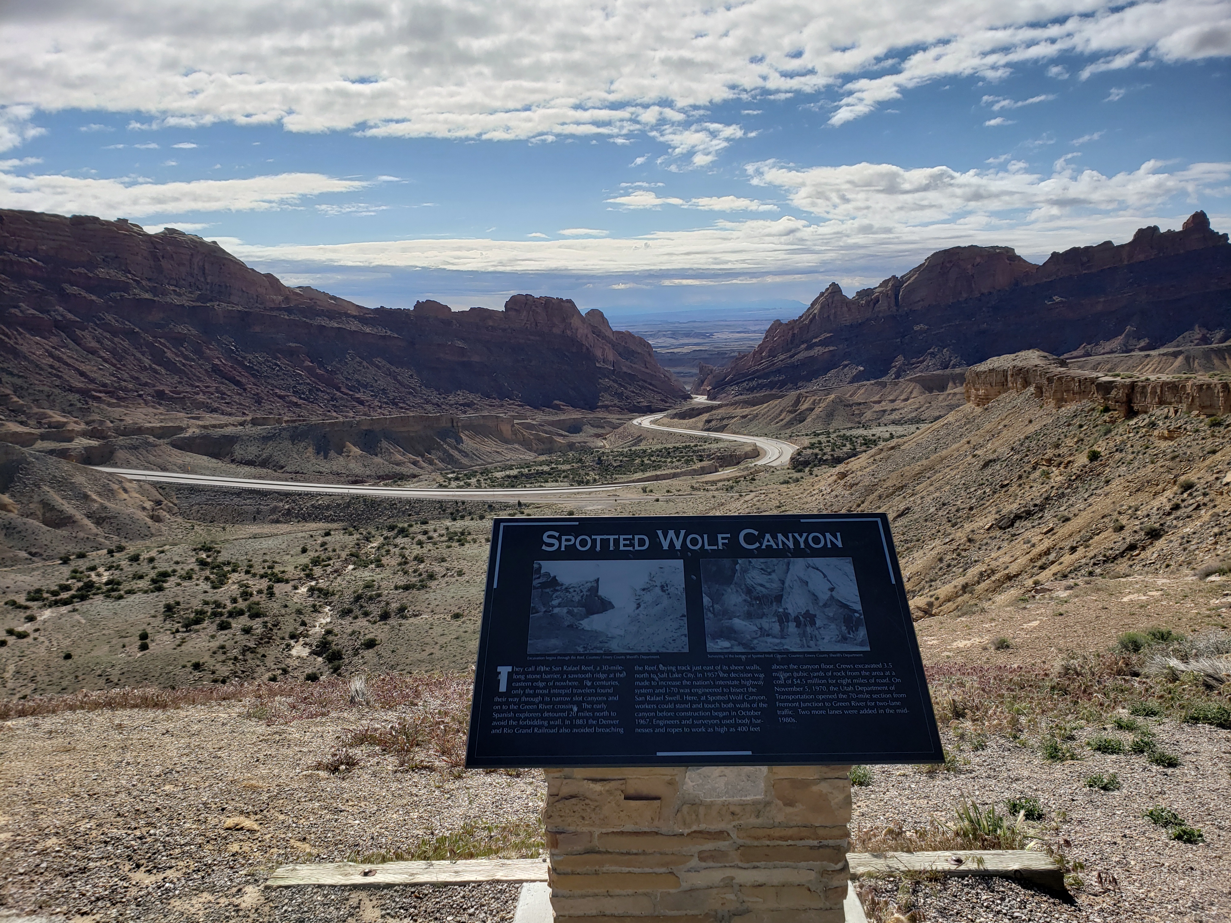
Spotted Wolf View Area
For my post about this section of Interstate 70 and links to the other rest areas on it visit this page.
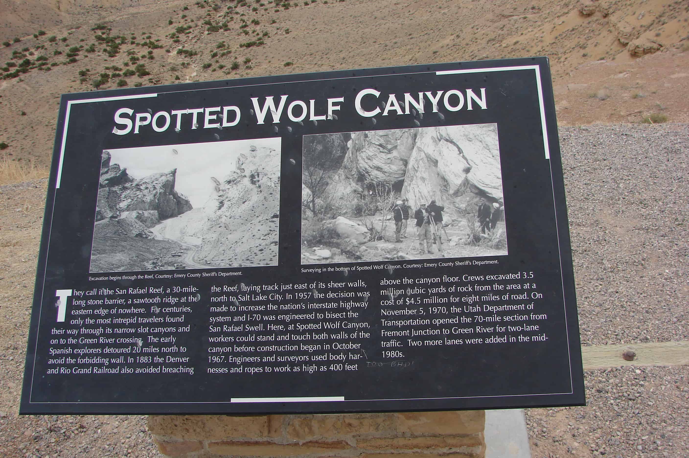
SPOTTED WOLF CANYON
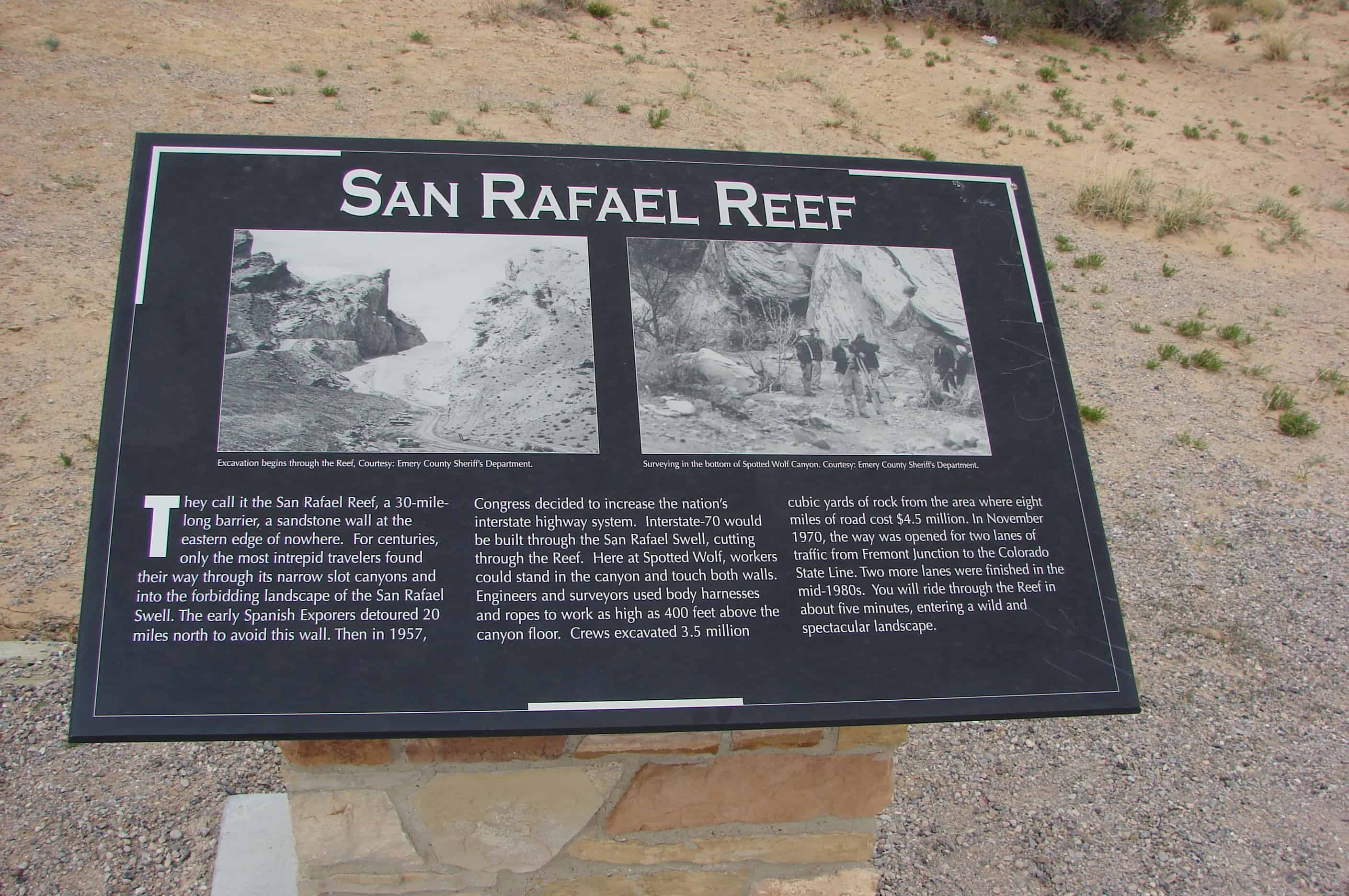
They call it the San Rafael Reef, a 30-mile- long stone barrier, a sawtooth ridge at the eastern edge of nowhere. For centuries, only the most intrepid travelers found their way through its narrow slot canyons and on to the Green River crossing. The early Spanish explorers detoured 20 miles north to avoid the forbidding wall. In 1883 the Denver and Rio Grand Railroad also avoided breaching the Reef, laying track just east of its sheer walls, north to Salt Lake City. In 1957 the decision was made to increase the nation’s interstate highway system and 1-70 was engineered to bisect the San Rafael Swell. Here, at Spotted Wolf Canyon, workers could stand and touch both walls of the canyon before construction began in October 1967. Engineers and surveyors used body harnesses and ropes to work as high as 400 feet above the canyon floor. Crews excavated 3.5 million cubic yards of rock from the area at a cost of $4.5 million for eight miles of road. On November 5, 1970, the Utah Department of Transportation opened the 70-mile section from Fremont Junction to Green River for two-lane traffic. Two more lanes were added in the mid- 1980s.
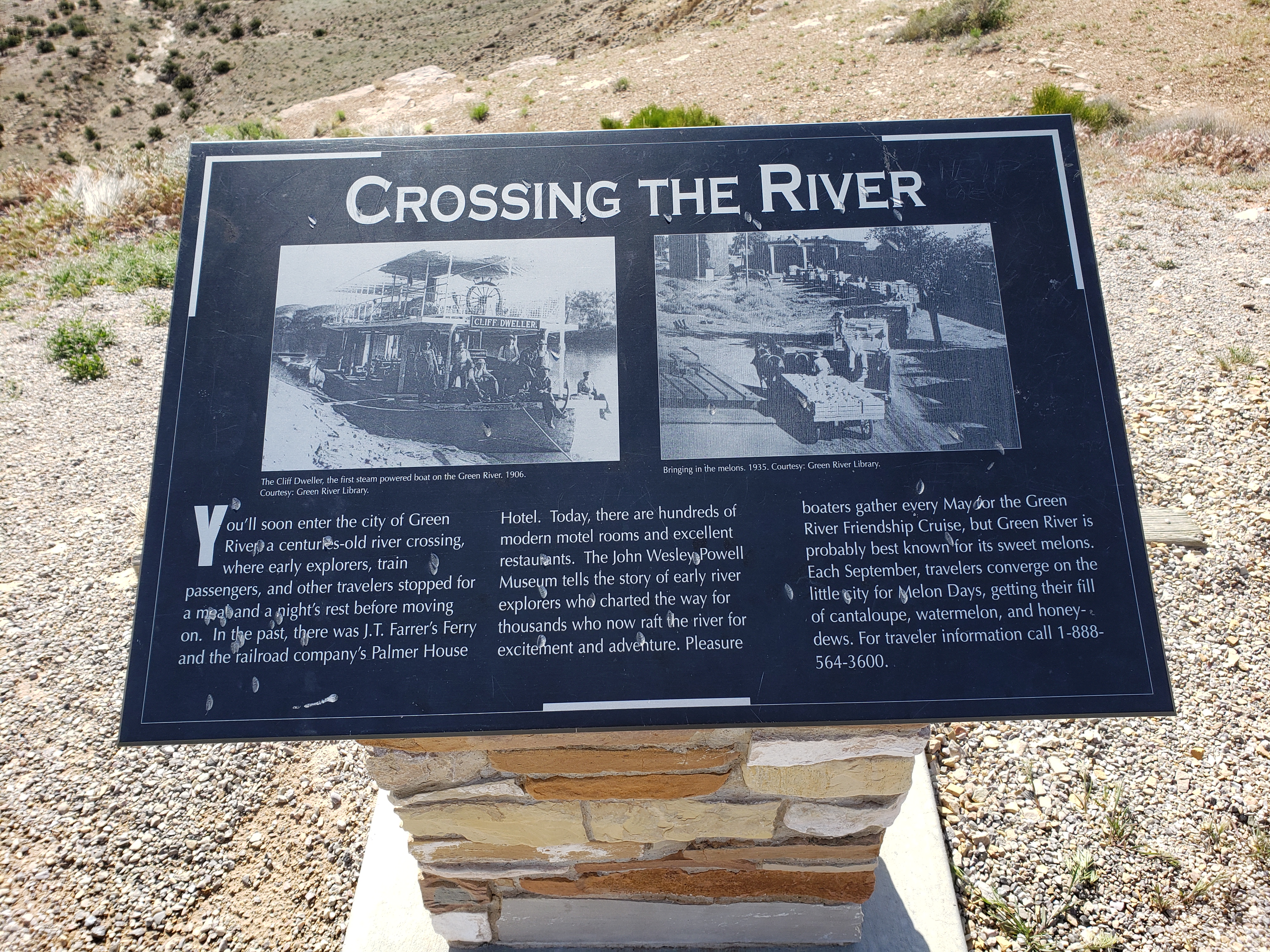
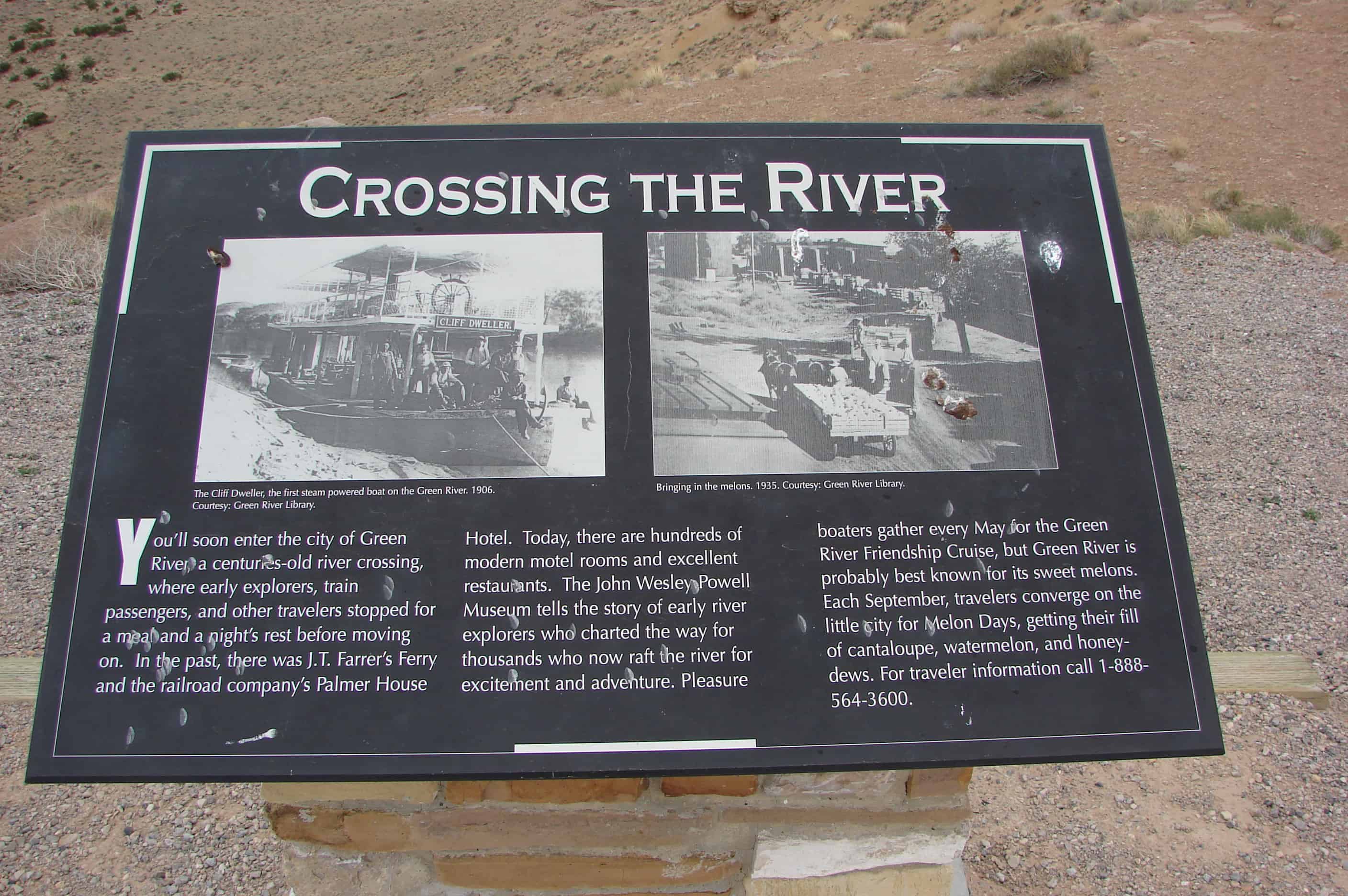
CROSSING THE RIVER
You’ll soon enter the city of Green River a centuries-old river crossing, where early explorers, train passengers, and other travelers stopped for a meal and a night’s rest before moving on. In the past, there was J.T. Farrer’s Ferry and the railroad company’s Palmer House Hotel. Today, there are hundreds of modern motel rooms and excellent restaurants. The John Wesley Powell Museum tells the story of early river explorers who charted the way for thousands who now raft the river for excitement and adventure. Pleasure boaters gather every May for the Green River Friendship Cruise, but Green River is probably best known for its sweet melons. Each September, travelers converge on the little city for Melon Days, getting their fill of cantaloupe, watermelon, and honeydews.
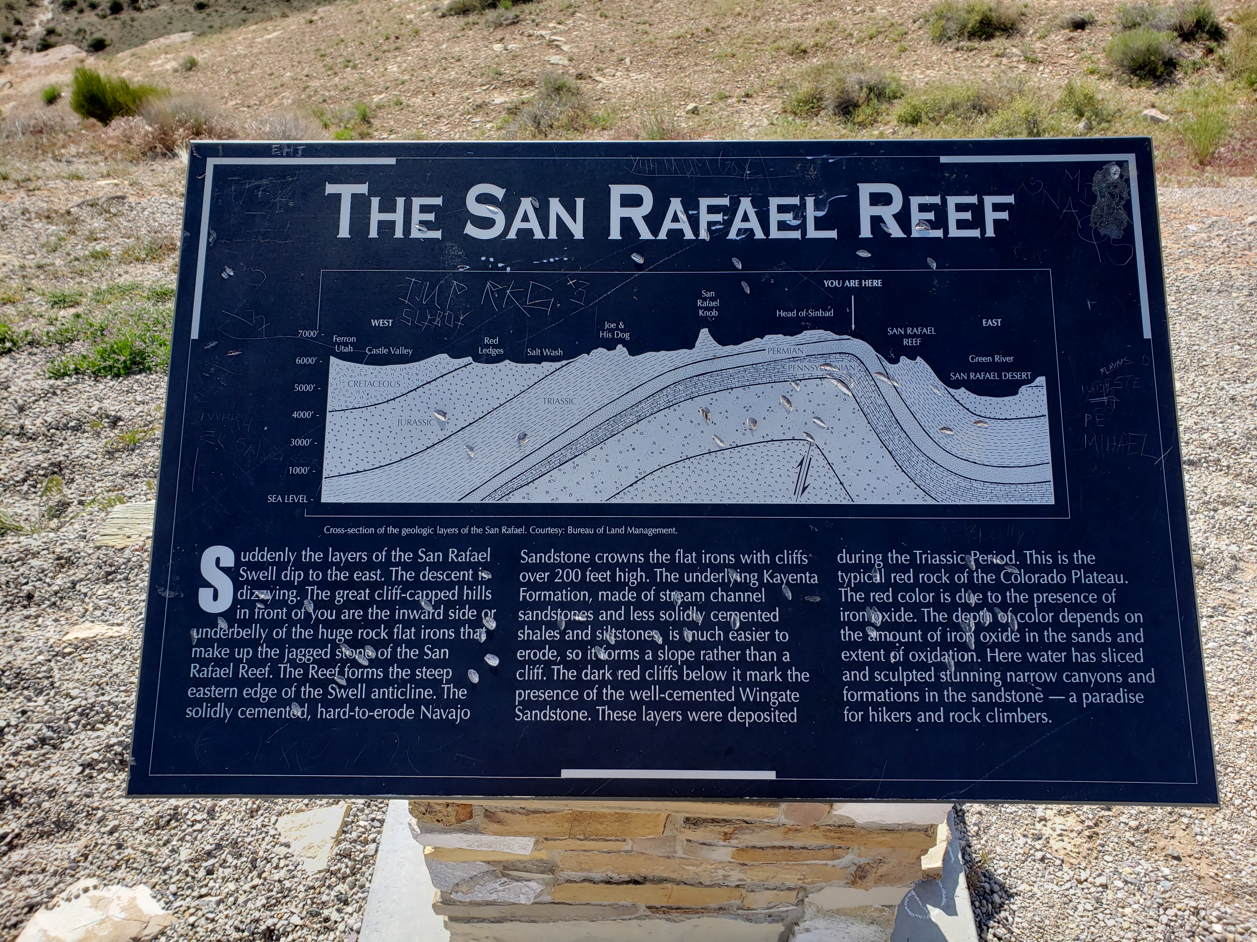
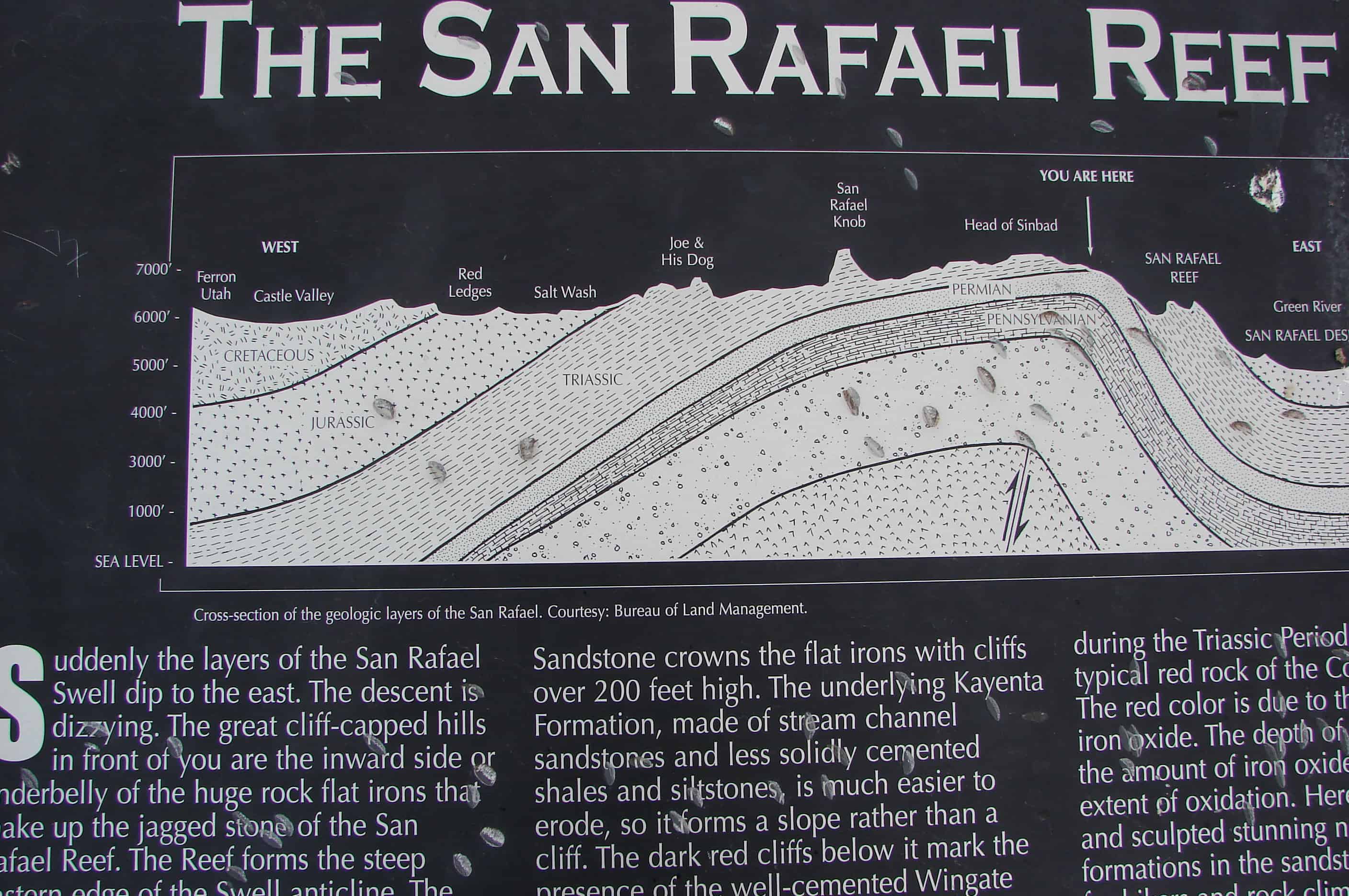
THE SAN RAFAEL REEF
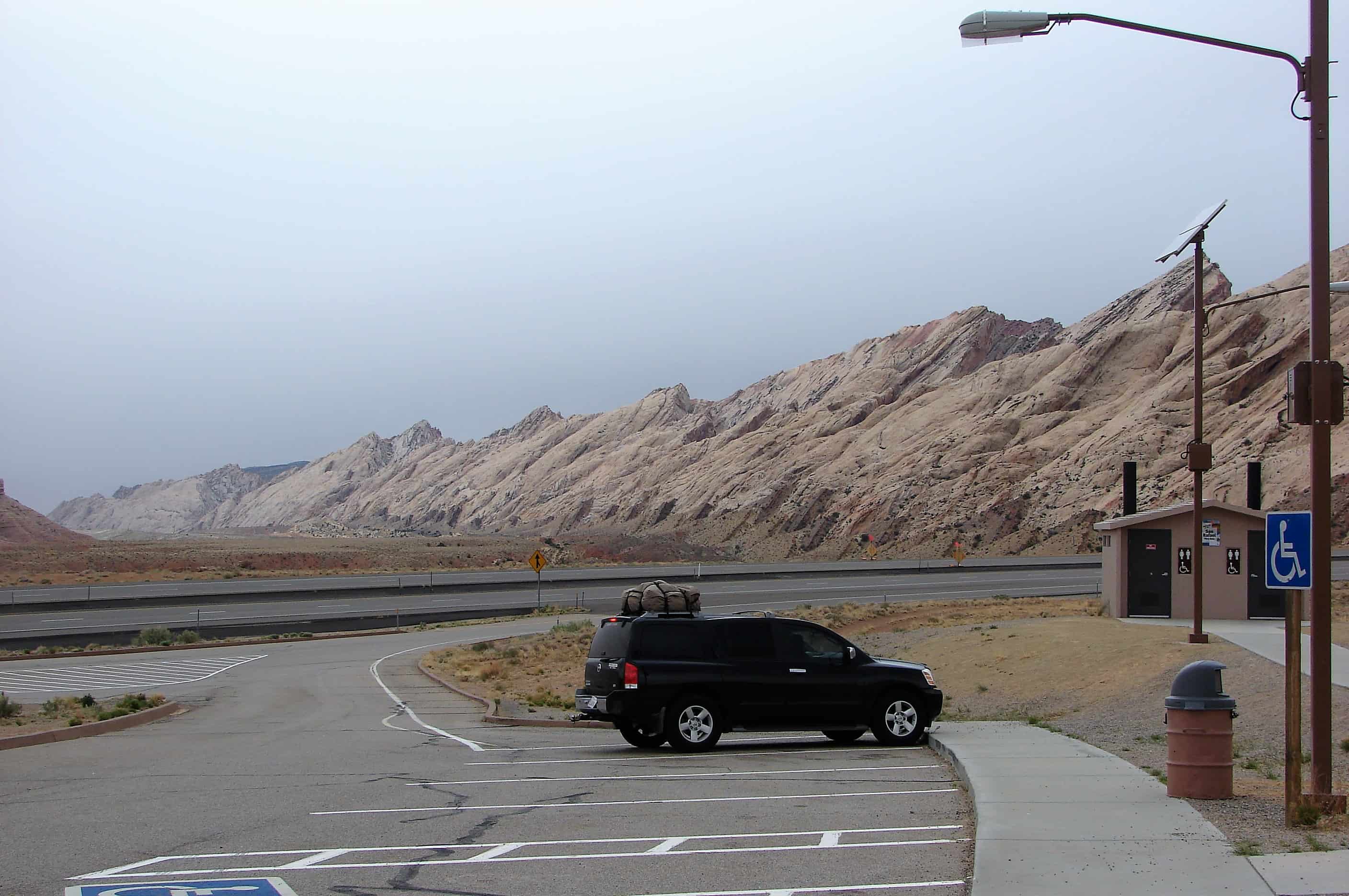
Suddenly the layers of the San Rafael Swell dip to the east. The descent is dizzying. The great cliff-capped hills in front of you are the inward side or underbelly of the huge rock flat irons that make up the jagged stone of the San Rafael Reef. The Reef forms the steep eastern edge of the Swell anticline. The solidly cemented, hard-to-erode Navajo Sandstone crowns the flat irons with cliffs over 200 feet high. The underlying Kayenta Formation, made of stream channel sandstones and less solidly cemented shales and siltstones, is much easier to erode, so it forms a slope rather than a cliff. The dark red cliffs below it mark the presence of the well-cemented Wingate Sandstone. These layers were deposited during the Triassic Period. This is the typical red rock of the Colorado Plateau. The red color is due to the presence of iron oxide. The depth of color depends on the amount of iron oxide in the sands and extent of oxidation. Here water has sliced and sculpted stunning narrow canyons and formations in the sandstone – a paradise for hikers and rock climbers.
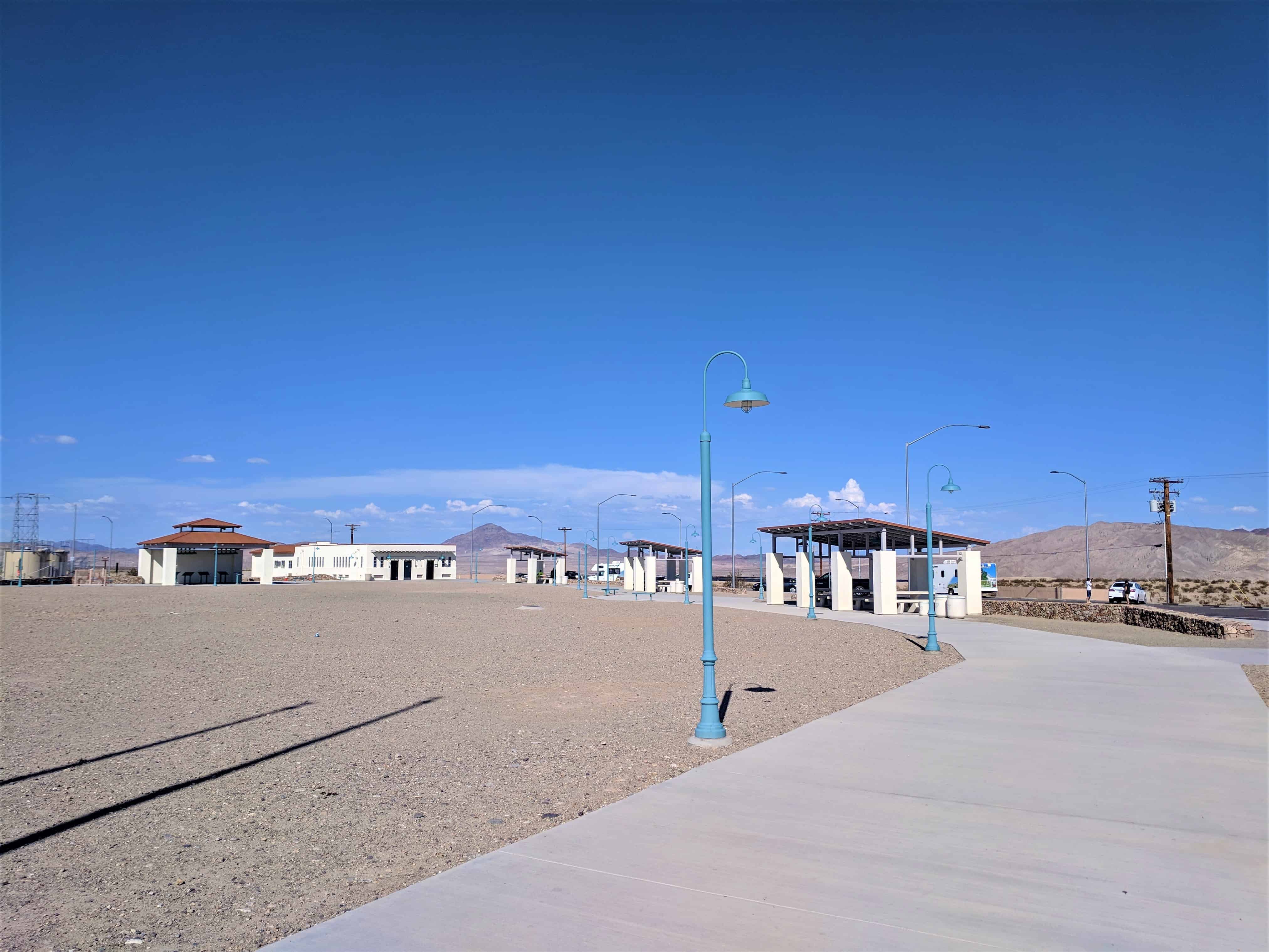
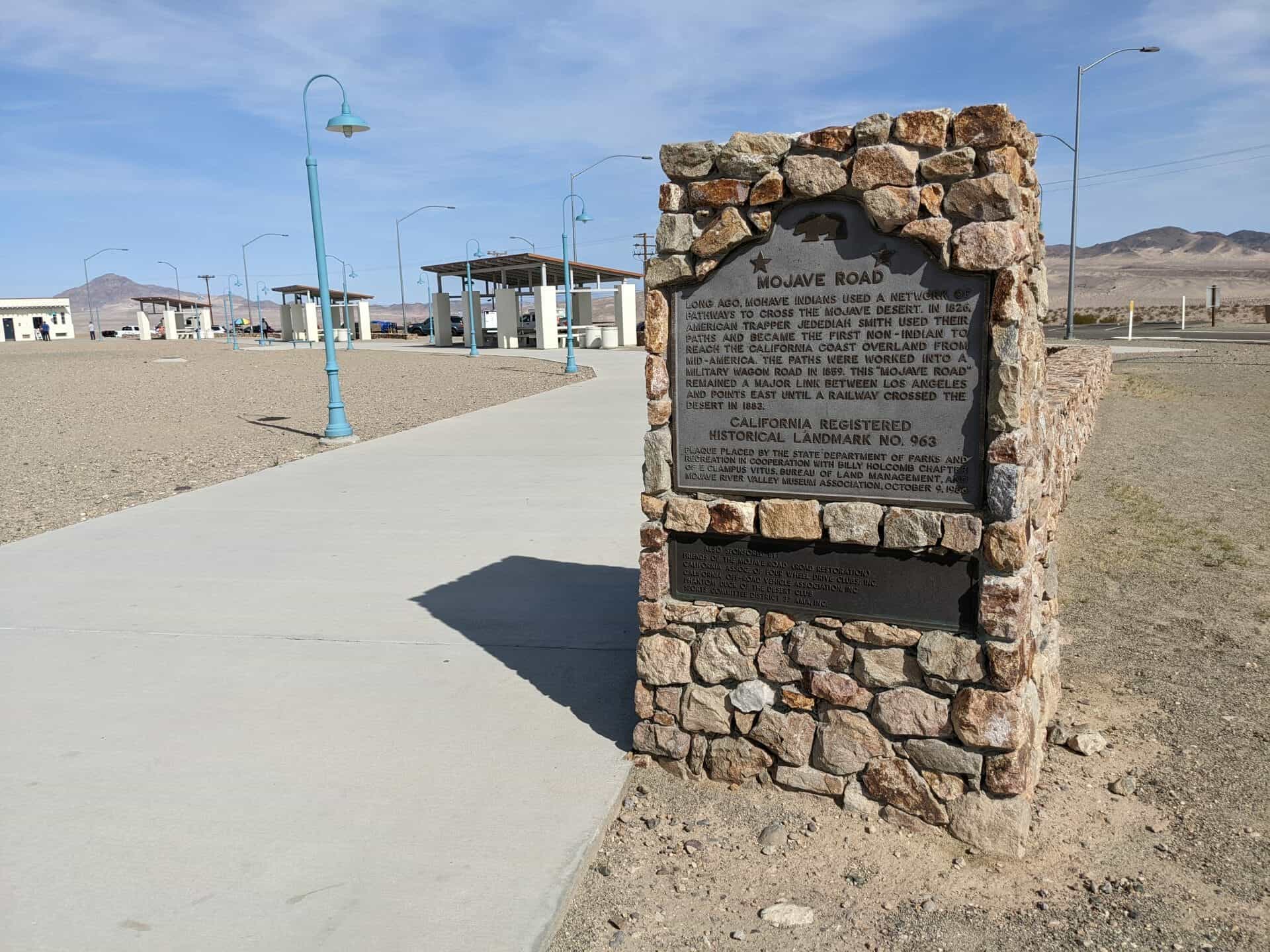
There are several rest areas to stop and see amazing views and read plaques and markers while traveling Interstate 70 across the San Rafael Swell in Utah.
This is also the longest stretch of freeway without gas so make sure you fill up, there are longer stretches of highway but as for freeway this is it.
Here is an assortment of some of the signs and things to see/read.
Forces at Work
The mountain to the southeast, the San Rafael Knob, is 7,921 feet above sea level, the highest point in the San Rafael Swell. This deep canyon is Devil’s Canyon. It cuts through the Carmel Formation, made of limestone and sandstone deposited in a sea that has gone for 180 million years.
The dramatically long and steep slopes below the Carmel are formed of Navajo sandstone, a formation prevalent through-out the Colorado Plateau, forming spectacular views throughout Utah and Colorado. You are still ascending the west side of the rock dome that is the San Rafael Swell. An anticline of huge proportions, the Swell was formed when forces below pushed up layers of rock in the earth’s crust. Erosion has worn away overlaying layers, forming the canyons, pinnacles, and peaks you see here and as you drive farther east. Imagine a rainbow with a rough and ragged flat top where every ribbon of color is revealed.
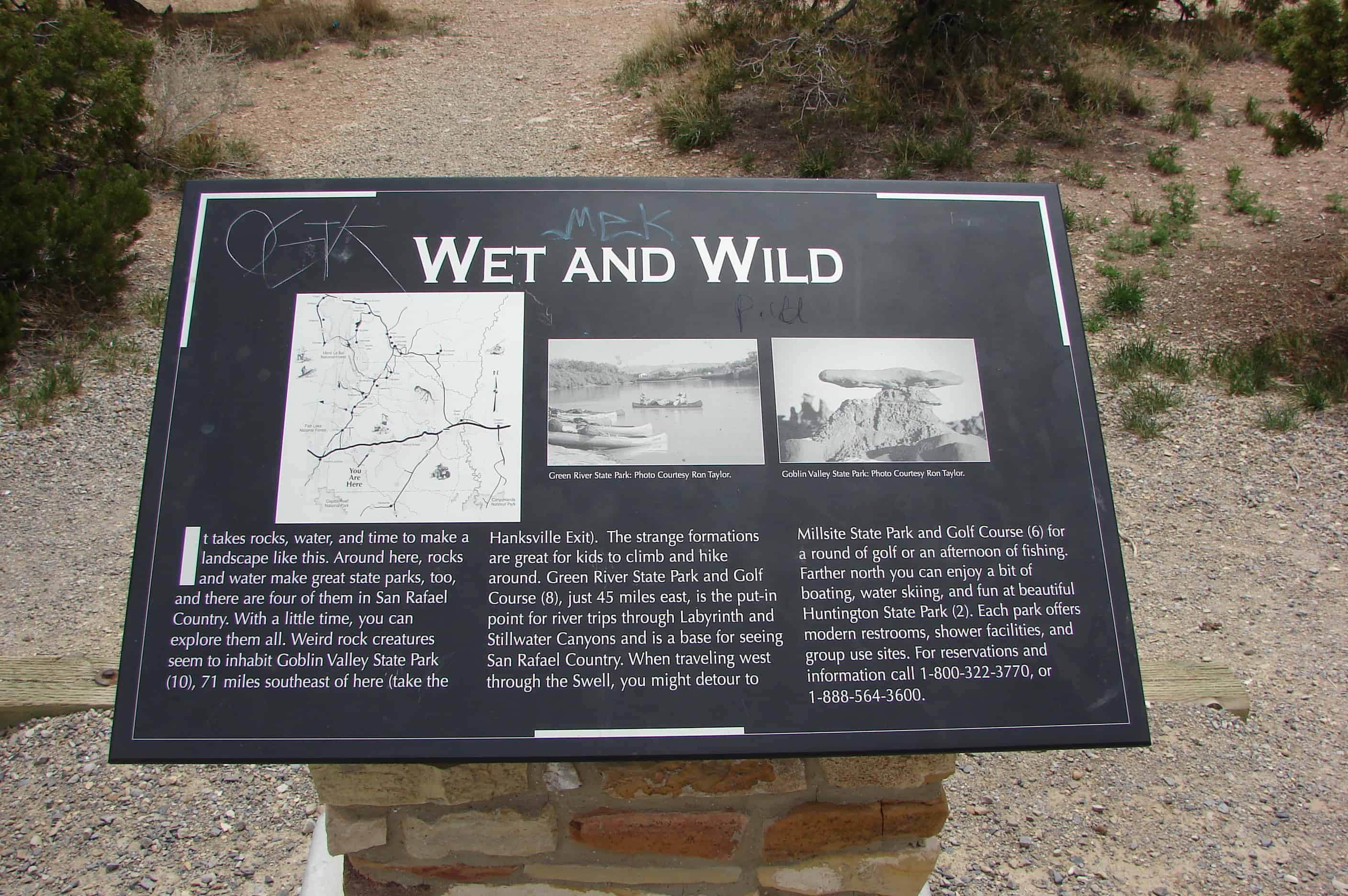
Wet and Wild
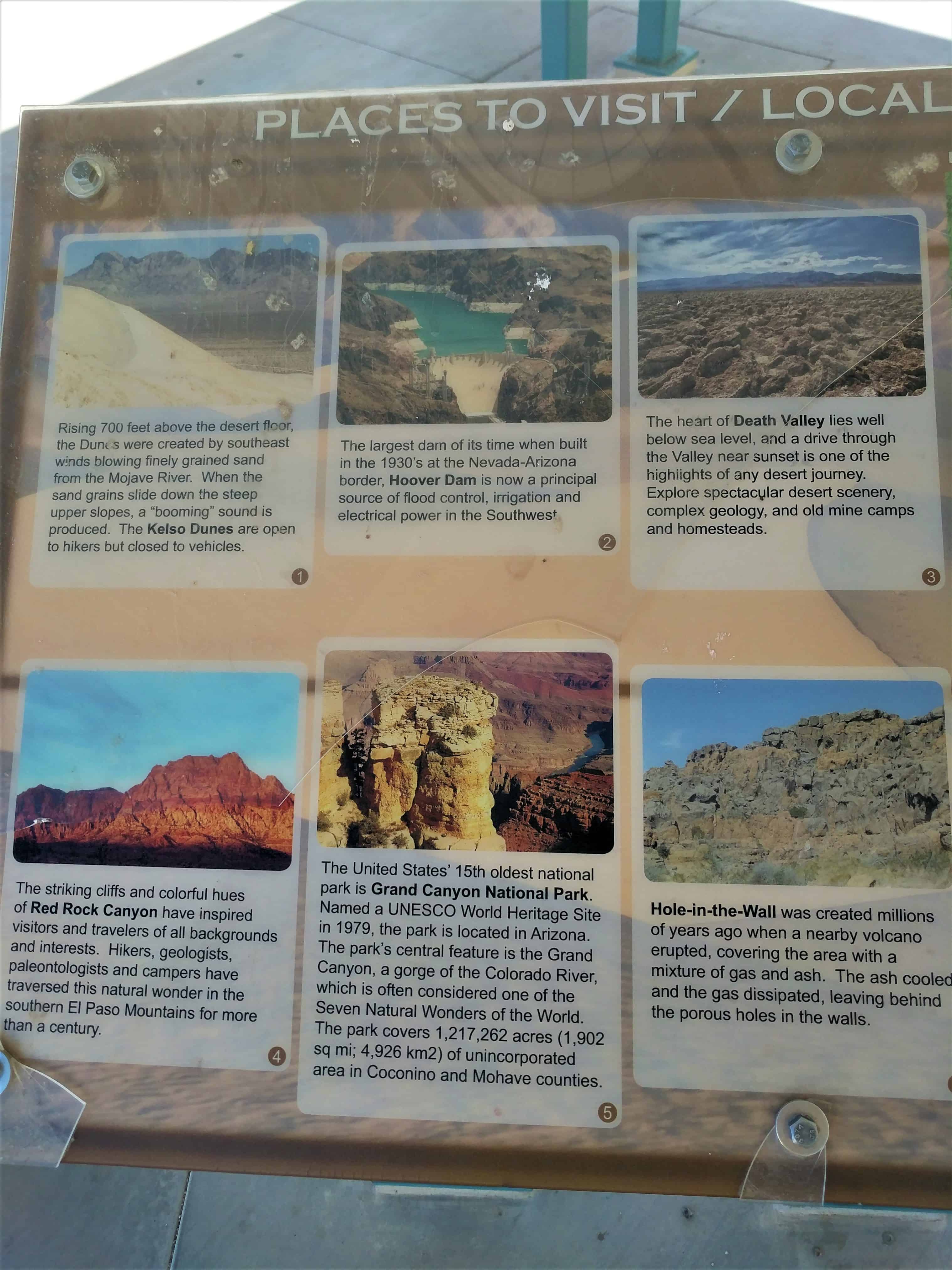
It takes rocks, water, and time to make a landscape like this. Around here, rocks and water make great state parks, too, and there are four of them in San Rafael County. With a little time, you can explore them all. Weird rock creatures seem to inhabit Goblin Valley State Park, 71 miles southeast of here (take the Hanksville Exit). The strange formations are great for kids to lcimb and hike around. Green River State Park and Golf Course, just 45 miles east, is the put-in point for river trips through Labyrinth and Stillwater Canyons and is a base for seeing San Rafael County. When traveling west through the Swell, you might detour to Millsite State Park and Golf Course for a round of gold or an afternoon of fishing. Father north you can enjoy a bit of beating, water skiing, and fun at beautiful Huntington State Park. Each park offers modern restrooms, shower facilities, and group use sites.
Home to Many
Humans have lived among these rocks and cliffs for longer than you can imagine. Archaeological investigations conducted as part of the interstate construction across the Swell during the 1970s and 1980s located over a hundred prehistoric sites. The sites show the hundreds of generations of Native American people inhabited this rugged land for thousands of years and in all seasons. Archaeologists explored sites from the early Archaic Period of hunting and gathering, about 9,500 years ago, up to historic ranching sites of the early 20th century. People survived by hunting and gathering until about the time of Christ, when small-scale agriculture, dependent on corn, beans, and squash, was adopted. Archaeological remains of these farmers, whom we call Fremonts, include small settlements of pit swellings, granaries, outdoor shaded work areas, hearths, storage pits, and trash mounds. The earliest evidence of farming on the Swell dates to about A.D. 500 at the Confluence Site. This site provided important insight into the transition from hunting and gathering to agriculture in the region, and predated previously known agriculture sites by 200 years, Bows and arrows and ceramics were the technological innovations of this time. Researchers found Fremont sites in the Ghost Rocks area, a few miles east of here, which is an upland environment and not well suited for growing corn. Study of the sites told archaeologists much about the Fremont way of life, which included hinting and gathering year-round and farming at lower elevations along riverbanks.
Ghost Rock
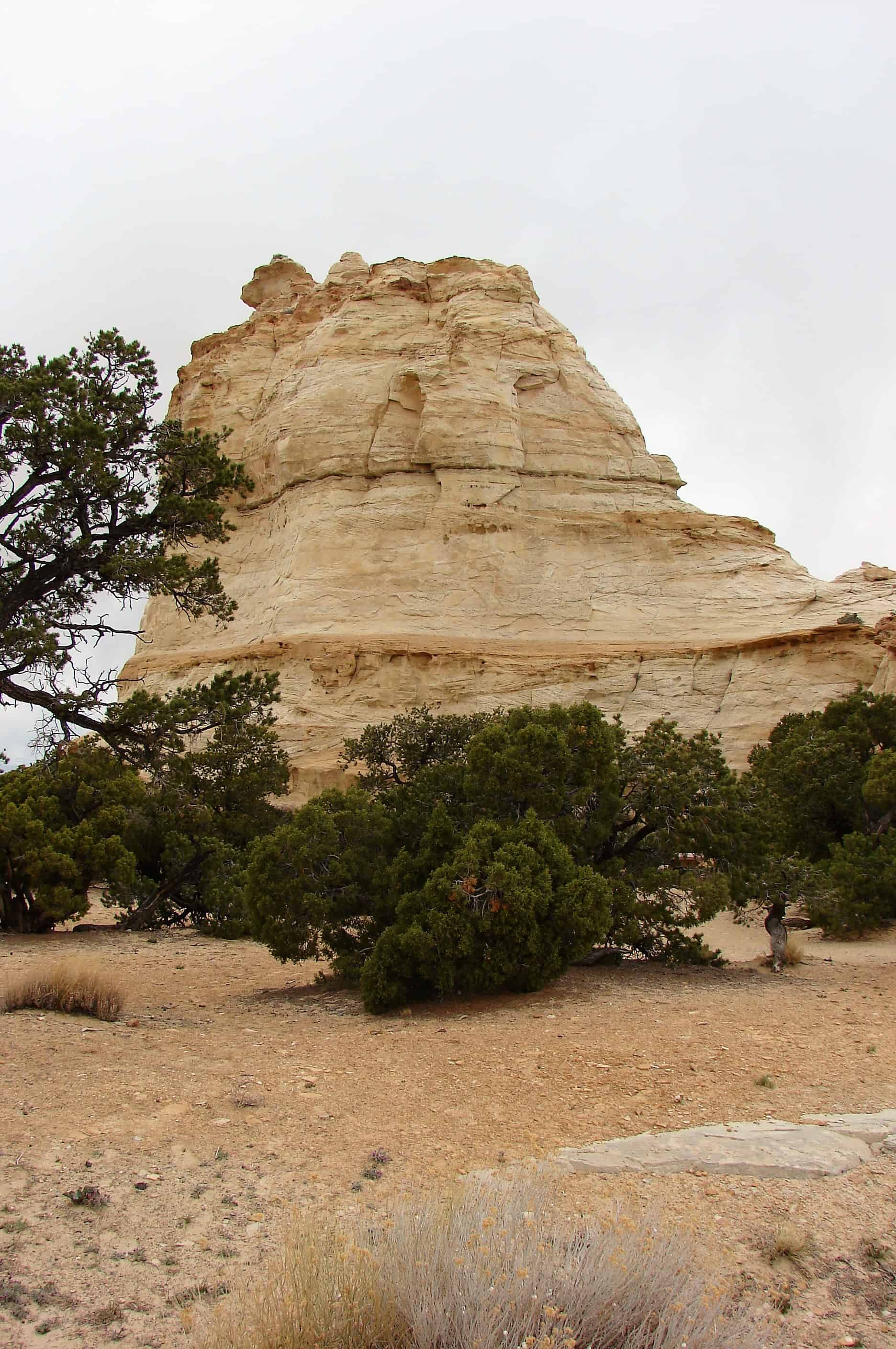
Imagine riding your horse through the San Rafael Swell in a heavy fog. Standing above the fog are two huge white rocks. Would you think you had seen a ghost? A cowboy thought so, hence its name – Ghost Rock. Cowboys in the Swell were a daring, tough lot, and the Swasey Brothers, (Charlie, Sid, Joe, and Rod) were tougher than most. They herded cows and rounded up wild horses here. Their cabin still stands, nestled in the white sandstone cliffs below, in an area called the Head of Sinbad. Here they built horse traps made from twisted juniper. It was here Joe had his “office” in an alcove in the white sandstone. Father east, Charlie bed Sid his herd of cattle that Sid couldn’t jump his horse across the deep San Rafael River gorge. It was about a 16-foot jump. He made the jump, won the cattle, and became a legend in San Rafael County.
Cowboys of the San Rafael
The Wild West is still wild in Castle Valley. Cowboys mounted on horseback still trail battle to high mountain pastures or to San Rafael Swell grazing allotments. During summer, rodeo cowboys take their chances on an eight-second ride at community-sponsored amateur rodeos such as the San Rafael Pro Rodeo, the Black Diamond Stampede, or sometimes just in the corral out back.
Almost anyone can enjoy a western adventure, brandin’, ropin’, and ridin’ with real cowboys of the San Rafael. Outfitters can guide you into the wilds of the San Rafael for the experience of a lifetime. You can reach the ranching communities of Castle Valley by taking the Moore Exit, following the Moore Road northwest to SR-10 and then north to Ferron. Turning south will take you to the town of Emery and on to the I-70 interchange at Fremont Junction.
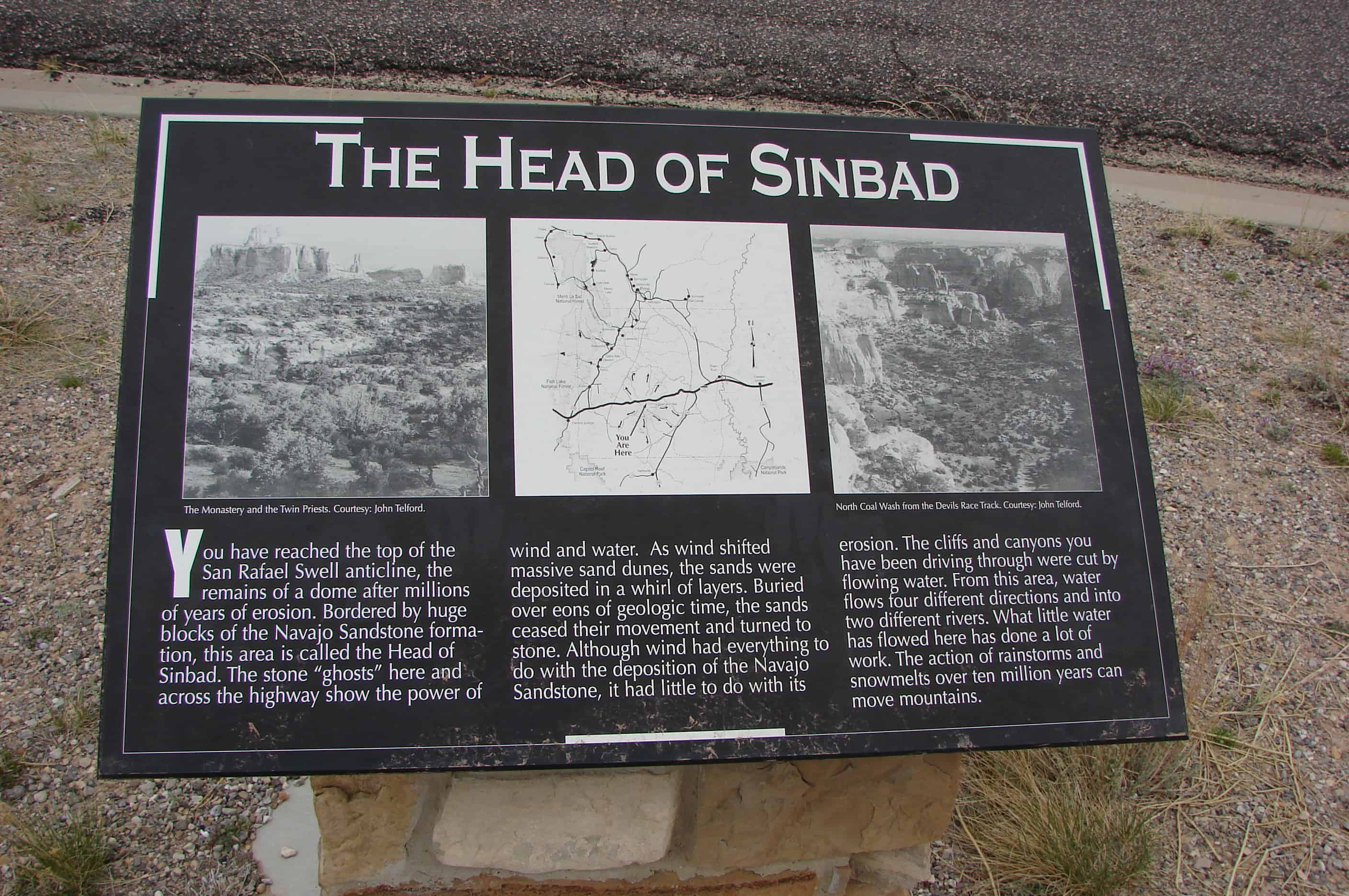
The Head of Sinbad
You have reached the top of the San Rafael Swell anticline, the remains of a done after millions of years of erosion. Bordered by huge blocks of the Navajo Sandstone formation, this area is called the Head of Sinbad. The stone “ghosts” here and across the highway show the power of wind and water. As wind shifted massive sand dunes, the sands were deposited in a whirl of laters. Buried over eons of geologic time, the sands ceased their movement and turned to stone. Although wind had everything to do with the deposition of the Navajo Sandstone, it had little to do with its erosion. The cliffs and canyons you have been driving through were cut by flowing water. From this area, water flows four different directions and into two different rivers. What little water has flowed here has done a lot of work. The action of rainstorms and snowmelts over ten million years can move mountains.
The San Rafael Reef
Suddenly the layers of the San Rafael Swell dip to the east. The descent is dizzying. The great cliff-capped hills in front of you are the inward side or underbelly of the huge rock flat irons that make up the jagged stone of the San Rafael Reef. The Reef forms the steep eastern edge of the Swell anticline. The solidly cemented, hard-to-erode Navajo Sandstone crowns the flat irons with cliffs over 200 feet high. The underlying Kayenta Formation, made of stream channel sandstones and less solidly cemented shales and siltstones, is much easier to erode, so it forms a slope rather than a cliff. The dark red cliffs below it mark the presence of the well-cemented Wingate Sandstone. These layers were deposited during the Triassic Period. This is the typical red rock of the Colorado Plateau. The red color is due to the presence of iron oxide. The depth of color depends on the amount of iron oxide in the sands and extent of oxidation. Here water has sliced and sculpted stunning narrow canyons and formations in the sandstone – a paradise for hikers and rock climbers.
Crossing the River
You’ll soon enter the city of Green River, a centuries-old river crossing, where early explorers, train passengers, and other travelers stopped for a meal and a night’s rest before moving on. In the past, there was J.T. Farrer’s Ferry and the railroad company’s Palmer House Hotel. Today, there are hundreds of modern motel rooms and excellent restaurants. The John Wesley Powell Museum tells the story of early river explorers who charted the way for thousands who now raft the river excitement and adventure. Pleasure boaters gather every May for the Green River Friendship Cruise, but Green River is probably best known for its sweet melons. Each September, travelers converge on the little city for Melon Days, getting their fill of cantaloupe, watermelon, and honeydews.
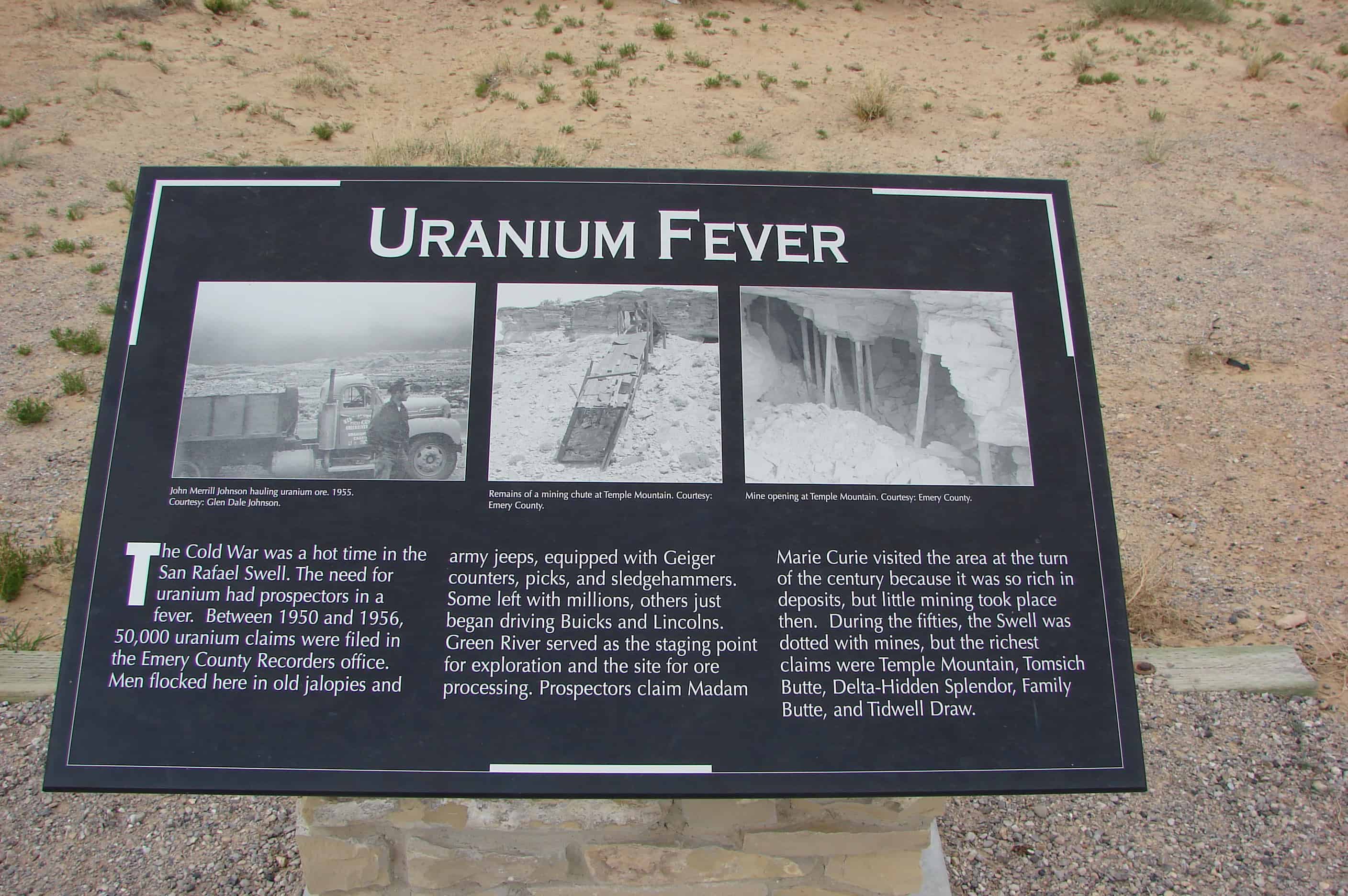
Uranium Fever
The Cold War was a hot time in the San Rafael Swell. The need for uranium had prospectors in a fever. Between 1950 and 1956, 50,000 uranium claims were filed in the Emery County Recorders office. Men flocked here in old jalopies and army jeeps, equipped with Geiger counters, picks, and sledgehammers. Some left with millions, others just began driving Buicks and Lincolns. Green River served as the staging point for exploration and the site for ore processing. Prospectors claim Madam Marie Curie visited the area at the turn of the century because it was so rich in deposits, but little mining took place then. During the fifties, the Swell was dotted with mines, but the richest claims were Temple Mountain, Tomsich Butte, Delta-Hidden Splendor, Family Butte, and Tidwell Draw.
The Silent City
The people of Green River call this the Silent City, a jagged cityscape formed by a great rock wall, the San Rafael Reef. You are about to enter and cross the San Rafael Swell, a large anticline where the earth’s crust has been heaved from below to form a great down of rock layers. Erosion, over millions of years, has erased the top of the dome. Imagine a rainbow with a rough and ragged flat top where every band of color is revealed. Here, at the eastern edge of the anticline, erosion has sliced and sculpted the steeply tiled layers of hard sandstone. Slot canyons, spectacular pour-offs, sheer cliffs, and miles of desert varnish remain. Exploring the San Rafael Swell off I-70 can be fascinating but dangerous to the novice. Be sure you have plenty of water, gasoline, good, and a reliable map.
San Rafael Reef / Spotted Wolf Canyon
They call it the San Rafael Reef, a 30-mile-long barrier, a sandstone wall at the eastern edge of nowhere. For centuries, only the most intrepid travelers found their way through its narrow slot canyons and into the forbidding landscape of the San Rafael Swell. The early Spanish Explorers detoured 20 miles north to avoid this wall. Then in 1957, Congress decided to increase the nation’s interstate highway system. Interstate-70 would be built through the San Rafael Swell, cutting through the Reef. Here at Spotted Wolf, workers could stand in the canyon and touch both wall. Engineers and surveyors used body harnesses and ropes to work as high as 400 feet above the canyon floor. Crews excavated 3.5 million cubic yards of rock from the area where eight miles of road cost $4.5 million. In November 1970, the way was opened for two lanes of traffic from Fremont Junction to the Colorado State Line. Two more lanes were finished in the mid-1980s. You will ride through the Reef in about give minutes, entering a wild and spectacular landscape.


