
The Ute Indians crossed this land since time immemorial. Chief Taby and Poteetneet crossing with their tribes each spring and fall.
Captain Fremont passed this way in 1843. John A Lawrence Pace and William Franklin Pace first looked down upon this land from the top of Billie’s Mountain (North) in 1852 while their father was at State Legislature from Spanish Fork. They called it Little Paradise Valley. The Grass grew 4 foot tall over all this land. A.C. Dean squatted on it in 1859 and irrigated and farmed 15 acres. William Franklin Pace bought him out in 1865 and increased it to 40 acres of irrigated land.
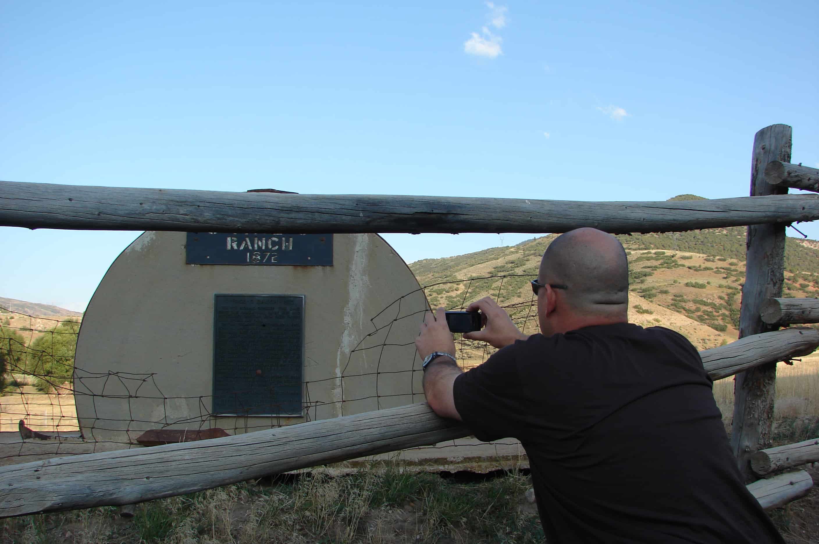
John Alma Lawrence Pace bought it from him for 150 head of cattle in 1872. He named it U-Pace-O Ranch. He increased irrigated land to 80 acres.
Alfred L Pace acquired part of farm in 1907 and all of it in 1926.
Robert C. Pace acquired part of it in 1944 and rest in 1960.


Pingback: Lake Fork | JacobBarlow.com
It’s my understanding that the Pace Ranch covered at least two separate plots. One of them was in Spanish Fork Canyon East of Thistle, below the Lake Fork District. Another was located in what is now known as “Covered Bridge Canyon.” The house shown above was located across the river at the mouth of that canyon–South of the parking lot West of “Castilla Springs” and some 7-10 miles west of the Lake District plot. We would pass this western piece regularly on our way to our family ranch in Wahrhodes Creek Basin, a tributary through Diamond Fork Creek to the Spanish Fork River.
It’s possible that the entire ranch was connected at one time, but if so, the acreage would probably have been much more than posted here. Covered Bridge Canyon itself is now a residential area covering numerous acres.
So they moved the house from the west plot to the east one? Interesting.
In looking closer at the photo, this house was actually located at Lake Fork. A twin, by appearance anyway, was located at Covered Bridge. Or it may have been moved down the canyon.
The one in my photo is still there at Thistle/Lake Fork. Still looking just like the photo, I go by it every day.
The last time I drove up Lake Fork was 20-30 years ago. At that time, I don’t believe there was a house there, but I may not have noticed. It’s possible that the family wanted to preserve the home and moved it when Covered Bridge Canyon was developed. That practice was fairly common in early days, even into the last half of the 20th Century.
A note from Emer Mayer Brimhall’s biography (available on his FamilySearch page) , who homesteaded property around Billie’s Mountain near Thistle, notes that “the [Brimhall] family went to church at the old Pace Ranch down the canyon.” That would indicate that in the late 1880’s, a house was on the property to the west.
“Brimhall Canyon” is located up Diamond Fork–to the North of Spanish Fork Canyon–and may be part of the huge acreage the Emer Brimhall family homesteaded (in excess if 1800 acres, according to the biography.)
Thank you for pursuing interest in the history of these areas. I’m fascinated myself with Wanrhodes Basin, which–as you may know–lies between Diamond Fork and Hobble Creek Canyon. That’s where several Springville families homesteaded ranches, including the Weight’s.
Do you know anything about what was on the monument/sign at Brimhall Canyon? (see here https://jacobbarlow.com/2020/05/07/brimhall-canyon/ )
Also, I love Wanrhodes. I think it’s one of the most beautiful canyons.
I’m not sure about the rock structure at Brimhall Canyon. It looks more like something the family could have constructed rather than a D.U.P. or S.U.P. monument. There was one of those near Palmyra/Diamond Campground commemorating a Black Hawk War battle, but the bronze plaque got removed several years ago.
Have you done anything on Wanrhodes? I have quite a bit of material on the Weight property, but would like to see what’s available on the history of other ranchers.
Pingback: John C. Fremont | JacobBarlow.com
Hello, I am the Niece of Robert G. (George) Pace, and the Grand Daughter of Alfred L. Pace. and just wanted to clarify a couple of things about the 2 ranches and the structure of the house on the U-Pace-O Ranch. The 2 ranches were separate ranches owned by Pace Brothers, the one at covered bridge was called the Pace Ranch and owned by William F Pace and his heirs, as you can follow the plaque on the U-Pace-O ranch sign you will see that is was also owned by William Pace and then later sold to John Alma Lawrence Pace (his brother), which was then owned by his heirs, the last Pace to own the property was Robert “David” Pace, son of Robert G. Pace.
I am the daughter of Wilson W. Pace brother of Robert G. Pace and was raised in Thistle and remember my Uncles place well. The house that you see on the property is part of the original house that was built on that land, it was until the late sixties or early seventies a one level house with a sod roof, during the time frame mentioned above Uncle Robert “Bob” remodeled the house and built on the upper story of the house which is what you still see standing today. If you have any other questions regarding this please let me know.
Carolyn, you’ve clarified for me the two different sections of the Pace property and who owned them. I’m still unsure about the houses. As I mentioned above, we used to pass the one located on the lower ranch when I was young–the 40’s through the ’60’s. It had much of the appearance of the one in the photos that’s apparently somewhere on the Lake Fork property.
Apparently there was a Branch of the LDS Church that met in the lower home, as referenced in the Emer Meyer Brimhall biography.
The lower “Pace Ranch” property was across the highway and river south of what was known as “Castilla”, a resort of late 19th-early 20th Century times. Warm mineral springs formed part of the attractiveness of the resort.
We had stories in our family of a David John, in the Presidency of the Utah Stake (of which Springville was a part in earlier days) complaining that the young men would skip Sunday School to go to Castilla on the Sabbath!
The area known as “Castilla” is still identified on a railroad signal device just as the tracks wend their way past Covered Bridge Canyon.
Yes they were 2 separate houses as I stated previously the one at Lake Fork that my Uncle Bob owned did not look like it does now it used to be a single story house with a sod roof, the upper floor of the house was added on later.
And yes Castilla was a health resort people would go there to soak in the hot springs water. I remember well the final bathing chamber that remained until the 1980’s, as kids living in Thistle we would go to Castilla and play in that room. My mother always told a story about my oldest brother being sprayed by a skunk and she had tried everything to get the smell off of him but nothing worked so she took him to Castilla to see if the spring water would help, she said that it didn’t but he did smell a little better.
I really enjoyed your blog about Castilla. Thank you for helping to keep the area remembered. I can still identify the location of the final bathing chamber when I drive through there. A really large boulder was placed on the site where the last chamber was.
I will look through my Mothers photo albums to see if I can find a picture showing the house in it’s original state at U-Pace-O Ranch.
For historical info on Castilla, here’s a link: https://historytogo.utah.gov/castilla-hot-springs/
Enjoy.