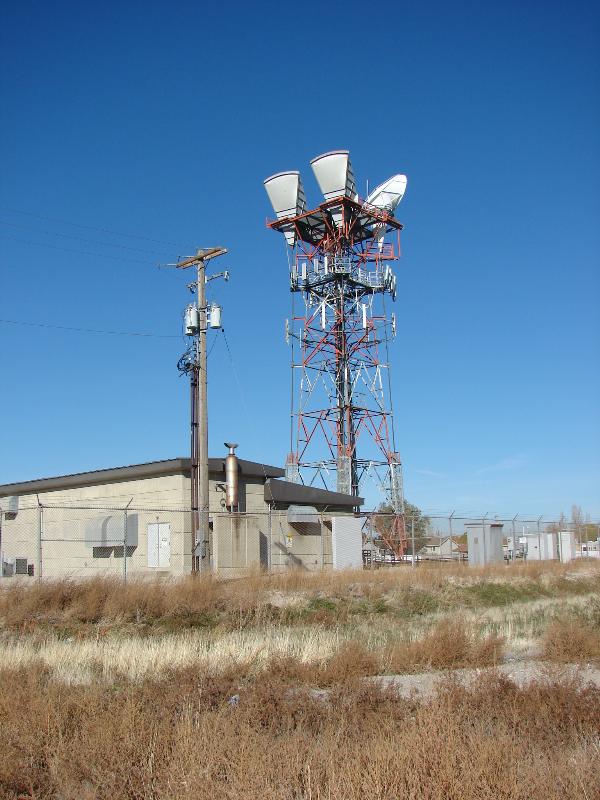
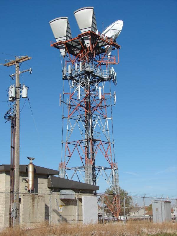
01/01/1973 by NGS (FIRST OBSERVED) DESCRIBED BY NATIONAL GEODETIC SURVEY 1973 (JRS) THE POINT INTERSECTED WAS THE RED LIGHT ATOP THE RIVERTON, AMERICAN TELEPHONE AND TELEGRAPH COMPANY, MICROWAVE TOWER, KPM 66 THAT IS LOCATED ABOUT 0.5 MILE WEST OF 1700 WEST IN RIVERTON AND JUST NORTH OF 12600 SOUTH. IT IS A FOUR LEGGED STRUCTURAL STEEL TOWER, PAINTED IN ALTERNATE BANDS OF RED AND WHITE WITH A FAN SHAPED ANTENNA LOCATED AT EACH OF THE FOUR CORNERS NEAR THE TOP. THE OVER ALL HEIGHT IS 105 FEET.
01/01/1963 by CGS (FIRST OBSERVED) DESCRIBED BY COAST AND GEODETIC SURVEY 1963 (JCC) THE STATION IS THE APEX OF THE BOX ELDER TABERNACLE SPIRE, LOCATED IN THE CENTRAL PART OF BRIGHAM CITY. THE STRUCTURE IS BUILT OF BRICK AND WOOD AND IS ABOUT 130 FEET HIGH.
See this link for other benchmarks I’ve documented.
Benckmark Disc set into the top of a metal pipe driven into the ground
01/01/1947 by USGS (MONUMENTED) DESCRIBED BY US GEOLOGICAL SURVEY 1947 (DHK) THE STATION, A U.S. GEOLOGICAL BENCH MARK, IS LOCATED ON THE HIGHEST POINT OF A PEAK LOCALLY KNOWN AS SPANISH FORK PEAK, IN THE UINTAH NATIONAL FOREST, BETWEEN HOBBLE CREEK (TRIBUTARY TO UTAH LAKE) AND NORTH CREEK (TRIBUTARY TO SOLDIER FORK CREEK). 6.3 MILES EAST-SOUTHEAST OF TOWN OF SPANISH FORK, 5.5 MILES SOUTHEAST OF SPRINGVILLE, 2.5 MILES NORTHEAST OF DENVER AND RIO GRANDE WESTERN RAILROAD, 12 FEET SOUTH OF THE NORTH BRIM, 9 FEET NORTH OF THE SOUTH BRIM, 8 FEET EAST OF A 6 FOOT ROCK CAIRN, SET IN TOP OF A 4 INCH PIPE, PROJECTS 2 FEET. IT HAS NO STAMPING ON MARK. REFERENCE MARK NO. 1 IS A U.S. GEOLOGICAL REFERENCE DISK APPROXIMATELY 5 FEET LOWER THAN THE STATION, SET ON THE SIDE HILL IN A OUTCROPPING BOULDER FLUSH WITH GROUND AND IS STAMPED NO 1. REFERENCE MARK NO. 2 IS A U.S. GEOLOGICAL REFERENCE DISK APPROXIMATELY 8 FEET LOWER THAN THE STATION, 18 FEET NORTH OF A 6 FOOT ROCK CAIRN, SET ON SIDE HILL IN AN OUTCROPPING BOULDER FLUSH WITH THE GROUND AND IS STAMPED NO 2. STATION HEAVEN 1947 WAS USED AS THE AZIMUTH. TO REACH FROM THE PUBLIC SCHOOL BUILDING IN MAPLETON. GO EAST FOR 0.85 MILE TO A T ROAD. TURN LEFT (N) AND GO 0.25 MILE TO A T ROAD. TURN RIGHT (E) AND GO 2.8 MILES UP CANYON TO A CATTLE GUARD. CROSS CATTLE GUARD AND GO 0.05 MILE TO A TRACK ROAD RIGHT. TURN RIGHT CROSSING A SMALL STREAM AND FOLLOW THIS ROAD FOR APPROXIMATELY 0.6 MILE TO A WIRE FENCE AT A SPRING AND WATERING TROUGH. (THIS POINT IS THE END OF TRUCK TRAVEL). FROM THIS POINT FOLLOW THE TRAIL SOUTHEAST UP CANYON FOR APPROXIMATELY 3.0 MILES TO A TRAIL LEADING RIGHT. TAKE THE LEFT FORK STRAIGHT AHEAD TO THE LAKE, THE STATION CAN BE SEEN FROM THE LAKE IN A NORTHWESTERLY DIRECTION. FOLLOW TRAIL NORTHERLY TO SADDLE THENCE LEFT AROUND THE NORTH SIDE OF MOUNTAIN TO THE HIGHEST POINT AND STATION SITE. HORSES CAN BE OBTAINED FROM MR. JAMES WISCOMB, LOCATED THE SECOND HOUSE WEST OF THE PUBLIC SCHOOL BUILDING IN MAPLETON. MR. WISCOMB IS THOROUGHLY ACQUAINTED WITH THE PEAK. A 2 HOUR AND 15 MINUTE HORSE PACK FROM THE END OF TRUCK TRAVEL.
DESCRIBED BY NATIONAL GEODETIC SURVEY 1954 6.0 MI W FROM THOMPSON. 6.0 MILES WEST ALONG THE DENVER AND RIO GRANDE WESTERN RAILROAD FROM THOMPSON, GRAND COUNTY, AT BRENDEL SIDING, ABOUT 1000 FEET WEST OF A WATER TANK, 60 FEET WEST OF MILEPOST 534, AND AT THE NORTH EDGE OF THE RIGHT-OF-WAY. A UNITED STATES GEOLOGICAL SURVEY STANDARD CAP, STAMPED 4898 1910 61 AND RIVETED ON THE TOP OF A 3-1/2-INCH IRON PIPE.
Benchmark: MS0710 “OGDEN DEL MONTE FOOD PROD TANK”
N 41.22196 W 112.00279
01/01/1963 by CGS (FIRST OBSERVED) DESCRIBED BY COAST AND GEODETIC SURVEY 1963 (JCC) THE STATION IS THE CENTER OF THE TOP OF A 174 FOOT HIGH WATER TANK. IT IS ABOUT 1 MILE EAST OF U.S. HIGHWAY 84 AND NEAR THE EAST END OF THE TOWN OF OGDEN. 01/01/1965 by CGS (GOOD) RECOVERY NOTE BY COAST AND GEODETIC SURVEY 1965 (JJC) THE INTERSECTION STATION WAS RECOVERED. THE TANK IS PAINTED GREEN ON ITS TOP AND BOTTOM WITH THE CENTER PORTION OF THE TANK PAINTED BLACK. 01/01/1973 by NGS (GOOD) RECOVERY NOTE BY NATIONAL GEODETIC SURVEY 1973 (DLS) STATION RECOVERED AS DESCRIBED IN GOOD CONDITION. AIRLINE DISTANCE AND DIRECTION FROM NEAREST TOWN IN TOWN.
In 1869 the United States Army sent First Lieutenant George M. Wheeler on a brief reconnaissance which later created the Country’s “Geographic Survey West of the One Hundredth Meridian”. This survey gave our leaders the first accurate mapping of the Western half of the Country, collecting data of the natural history, geology, geography, climate, weather and ethnology.