• About JacobBarlow.com
  • Cemeteries in Utah
  • D.U.P. Markers
  • Doors
  • Exploring Utah Email List
  • Geocaching
  • Historic Marker Map
  • Links
  • Movie/TV Show Filming Locations
  • Oldest in Utah
  • Other Travels
  • Photos Then and Now
  • S.U.P. Markers
  • U.P.T.L.A. Markers
  • Utah Cities and Places.
  • Utah Homes for Sale
  • Utah Treasure Hunt

JacobBarlow.com

~ Exploring with Jacob Barlow

JacobBarlow.com

Monthly Archives: October 2017

Russell Swenson Baseball Complex

30 Monday Oct 2017

Posted by Jacob Barlow in Uncategorized

≈ 1 Comment

Tags

Parks, spanish fork, utah, utah county

  • 2017-09-13 19.29.52

Russell Swenson Baseball Complex in Spanish Fork.

Russell M. Swenson Memorial Park

Dedicated to the memory of Russell M. Swenson, the number one booster for the Spanish Fork Dons, BYU Cougars, and the Little League Yankees.  He approached life and sports with great enthusiasm.  His voice could be heard all over the ballpark as he led team cheers between every inning and at the end of each game.  Russell found new adventure in each day and extended this excitement to everyone with whom he came in contact.  He worked at this ballpark for over twenty years, taking great pride in his work.   Spanish Fork City is a better place to live because of Russell.  He never missed a game while in this life and his influence will always be felt in this park.

See also:

  • Parks in Spanish Fork
2017-09-13 19.33.10
2017-09-13 19.33.18
2017-09-13 19.33.35
2017-09-13 19.34.11
2017-09-13 19.39.36
2017-09-13 19.31.43
2017-09-13 19.30.15
2017-09-13 19.30.03
2017-09-13 19.25.39
2017-09-13 19.23.22
2017-09-13 19.23.19

Andersen’s Tower

30 Monday Oct 2017

Posted by Jacob Barlow in Uncategorized

≈ 1 Comment

2017-09-13 19.09.32

I’ve been looking for some info or history on this place in Spanish Fork but here’s some pictures of it in the meantime.

2017-09-13 19.09.55

2017-09-13 19.09.25

2017-09-13 19.09.21

North Visitor Center

30 Monday Oct 2017

Posted by Jacob Barlow in Uncategorized

≈ 1 Comment

Tags

LDS Church, Salt Lake City, Salt Lake County, Temple Square, utah

2017-09-10 18.21.56

The North Visitor Center at Temple Square in Salt Lake City.

2017-09-10 19.17.32-1
2017-09-10 18.57.44
2017-09-10 18.28.14
2017-09-10 18.22.26

South Visitor Center

30 Monday Oct 2017

Posted by Jacob Barlow in Uncategorized

≈ 2 Comments

Tags

LDS Church, Salt Lake City, Salt Lake County, Temple Square, utah

2017-09-10 19.20.22

The South Visitor Center at Temple Square in Salt Lake City.

2017-09-10 19.22.40

Here are some more photos by Chris Sirrine on this page.

2017-09-10 19.23.10
2017-09-10 19.23.12
2017-09-10 19.23.16
2017-09-10 19.23.47
2017-09-10 19.24.06

Mormons in Star Valley

30 Monday Oct 2017

Posted by Jacob Barlow in Uncategorized

≈ 1 Comment

Tags

Afton, LDS Church, Lincoln County, Wyoming

c1b5bdbb-825a-4662-985a-c3ef663314d2

First Mormons of record in the valley were 40 emigrants, miners from England, employed in 1858 by F.W. Lander to work on the Lander Cut-Off of the Pacific Wagon Road. By 1870 Church cattle were summer pastured in the valley. In 1879 the Church directed the colonization of the valley. In August 1880 apostles Moses Thatcher and Charles C. Rich renamed Salt River Valley to Star Valley and dedicated it for settlement by organizing a branch of the Bear Lake Stake with Charles Drake Cazier as president with 21 members in 5 households in the valley. 1880 census shows 45 persons in the valley. 1900 census shows 2,219. In 1892 the Star Valley Stake was formed with 7 Wards. The rock meeting house in Auburn was built in the winter of 1889 and the tabernacle in Afton in 1905. In the Church of Jesus Christ of Latter Day Saints Sesquicentennial year 1997 there exists the Afton and Thayne Stakes. There are 15 wards including Smoot, Osmond, Fairview, Salt River, Afton 1st, 2nd, 3rd, and 4th, Grover, Auburn, Bedford, Thayne 1st and 2nd, Freedom and Etna/Alpine, with a combined membership of 6,214. Welcome to Star Valley.

bb4e5e4d-884c-41e1-b55b-f400dce86507

Lander Cut-Off of the Oregon Trail

29 Sunday Oct 2017

Posted by Jacob Barlow in Uncategorized

≈ 1 Comment

10a7795d-1ffc-4a59-8387-9df18199b030

Beginning in 1843, emigrants traveled across the continent along what became known as the Oregon Trail. Increased traffic during the 1850’s resulted in the first government road construction project in the west. The 345 mile Central Division of the Pacific Wagon Road went from South Pass, Wyoming, to City of Rocks, Idaho, a geologic formation, which marked the Division’s western boundary. Superintendent Frederick W. Lander of Salem, Massachussetts, supervised construction for the U. S. Department of the Interior. The 256 mile section of the road leading from South Pass to Fort Hall, Idaho, is known as the Lander Cut-off. The cut-off traversed this Salt River Valley for 21 miles and parallels Highway 89 through this area. The new route afforded water, wood, and forage for emigrants and their stock. Between 1858 and 1912, it provided travelers with a new, shorter route to Oregon and California, saving wagon trains seven days. Lander, with a crew of 15 engineers, surveyed the route in the summer of 1857. The following summer, 115 men, many recruited from Salt Lake City’s Mormon emigrants, constructed the road in less that 90 days at a cost of $67,873. The invention of the automobile led to its abandonment.

15427ce0-e214-44c8-82ef-d158c575a1b3

Lombard Ferry

29 Sunday Oct 2017

Posted by Jacob Barlow in Uncategorized

≈ 1 Comment

03fd1531-3f09-426c-847d-3d9ba5542e09

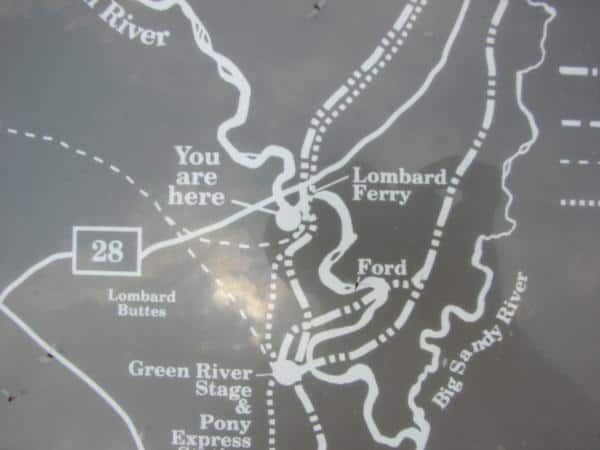
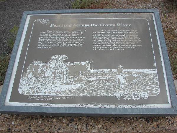
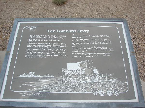
The Green River presented a major obstacle to the westward bound emigrants. Throughout Crossing the Green River the years of the emigration, a number of different locations were used to ford, float, or ferry over the rivers. The most popular means of crossing for those on the main branch of the westward emigrant trails was the “Lombard Ferry,” established by mountain men in 1843. In 1850, the mountain men sold out to the Mormons who ran the ferries for the next eight years. At that time, it was usually called the Green River Mormon Ferry. The name Lombard Ferry did not attach to the site until after the emigration, when William Lombard took over the operation in 1889.

During the peak emigration months of May, June, and July, emigrants sometimes had to wait You can still see evidence of campsites. Axe chopped trees, etc.several days to cross. Evidence of the vast camping area can still be found on the eastern shores of the river, along with ruts leading away from the site. Rates could go as high as $16 per wagon for the crossing. Those emigrants who could not afford the toll or were too impatient to wait their turn often lost everything when they misjudged the current or slipped off the narrow gravel bar that allowed safe passage.

Other crossings in this area include the Robinson Ferry, a few miles south of Lombard Ferry. The Robinson Ferry was built by the Mormons in 1847 and operated by them until 1856 when it became the operation of Isaac Bullock and Lewis Robinson. A few years later, Indians attacked the Robinson homestead, killing all but a young girl. The ferry was then abandoned. The Robinson Ferry site is also within the Seedskadee National Wildlife Refuge.

15fa44fa-08e0-4f59-9d4f-ae51862a7ba1

f3f9e241-802a-4df8-a612-7882820434d8

faa7d6cd-e16e-44c4-be33-1413838be8e7

Simpson’s Hollow

29 Sunday Oct 2017

Posted by Jacob Barlow in Uncategorized

≈ 2 Comments

Tags

Historic Markers, Sweetwater County, The Utah War, Wyoming, Wyoming Historic Markers

e1809295-ba01-43c8-80bb-d2036fc938c3

2018-01-05 15.03.43

Here on Oct. 6 1857 U.S. Army Supply wagons led by a capt. Simpson were burned by a Major Lot Smith and 43 Utah Militia Men.  They were under orders from Brigham Young, Utah Territorial Governor, to delay the army’s advance on Utah.  This delay of the army helped affect a peaceful settlement of difficulties.

The day earlier a similar burning of 52 army supply wagons took place near here at Smith’s Bluff.

There are four historic markers here:

  • Burning Wagons
  • Simpson’s Hollow
  • Simpson’s Hollow
  • The Utah War

2018-01-05 15.04.18

2018-01-05 15.05.05

2018-01-05 15.05.09

afc9bc1b-32af-42eb-a513-cabc58a2ee5a

2d8c1fdc-ab7f-4f89-a70a-4fd215917909

James Bridger – Trapper 1844

27 Friday Oct 2017

Posted by Jacob Barlow in Uncategorized

≈ 2 Comments

Tags

Historic Markers, Wyoming, Wyoming Historic Markers

  • f6756095-b239-4430-9557-9a24621f6815

Names Hill, located on the west side of Highway 189 about 5 miles south of LaBarge, is a very important location, being on the west side of the Green River where thousands of people made a crossing and camped before going on to Immigrant Springs and on down into Utah. Hundreds of names had been carved in the rocks: many of them now have crumbled away. The most famous is James Bridger. To protect it a fences has been placed around it and a marker placed next to it which reads:

“He little knew that when he cut his name, or had it cut, in this stone, that it would be engraved in the annals of the West deeper than that of any other man. As one of the world’s outstanding explorers he guided emigrants, railroads and army in the expansion of the nation”

43b81603-0c8a-4e26-8011-83ef19ae76ee
5400286a-c0ea-4680-8e21-ae3c5a2ed6d2
710f5541-6749-4c61-820d-50d4f94a3ca0

Almy

27 Friday Oct 2017

Posted by Jacob Barlow in Uncategorized

≈ 2 Comments

Tags

Historic Markers, Wyoming, Wyoming Historic Markers

a12fffac-0c8f-48b2-896b-c8d80ce07708

Nineteenth Century railroads were dependent upon coal for fuel. The vast coal reserves of southern Wyoming helped determine the route of the transcontinental Union Pacific Railroad and were the basis for Wyoming’s first energy boom. Communities sprang up along the line and several with coal deposits or rail facilities survived. Coal mines were opened in the surrounding Bear River Valley in 1868. Dreams of prosperity lured miners from England, Scandinavia, China, and from throughout the United States to settle in “Wyoming Camp”, which later became Almy. Named for James T. Almy, a clerk for the Rocky Mountain Coal Company and located three miles northwest of Evanston, Almy was strung out along the Bear River for 5 miles. This particular “string-town” owed its existence soley to coal mining. Her 4,000 residents suffered more than their share of mining tragedies. On March 4, 1881, the first mine explosion west of the Mississippi to claim lives, killed 38 men in just one of many serious disasters to strike Almy. In January of 1886, 13 more died and on March 20, 1895, the third worst mine explosion in Wyoming history, claimed the lives of 61 men. The state Coal Mine Inspector determined the Almy mines “among the most dangerous in the state”. Finally, in 1900 the mines were closed by the Union Pacific due to labor troubles and explosions. Almy lost its principal industry, the population dwindled and the town suffered the fate of many railroad coal towns throughout Wyoming.

ec531998-9ded-4724-b6ae-d619fe814633

← Older posts

Follow Jacob

Follow Jacob

Come wander with me on Youtube.

Blog Stats

  • 2,096,319 hits

Social and Other Links

BarlowLinks.com

Recent Posts

  • Scout Monument
  • Provo High School Seminary Building
  • 821 E 100 S
  • 820 E 100 S
  • 817-819 E 100 S

Archives

Loading Comments...