• About JacobBarlow.com
  • Cemeteries in Utah
  • D.U.P. Markers
  • Doors
  • Exploring Utah Email List
  • Geocaching
  • Historic Marker Map
  • Links
  • Movie/TV Show Filming Locations
  • Oldest in Utah
  • Other Travels
  • Photos Then and Now
  • S.U.P. Markers
  • U.P.T.L.A. Markers
  • Utah Cities and Places.
  • Utah Homes for Sale
  • Utah Treasure Hunt

JacobBarlow.com

~ Exploring with Jacob Barlow

JacobBarlow.com

Monthly Archives: October 2017

Seeds-Kee-Dee-Agie

27 Friday Oct 2017

Posted by Jacob Barlow in Uncategorized

≈ 2 Comments

Tags

Historic Markers, Wyoming, Wyoming Historic Markers

d8e9c1b6-b63f-48cb-9dac-bc8a0ba4bb4a

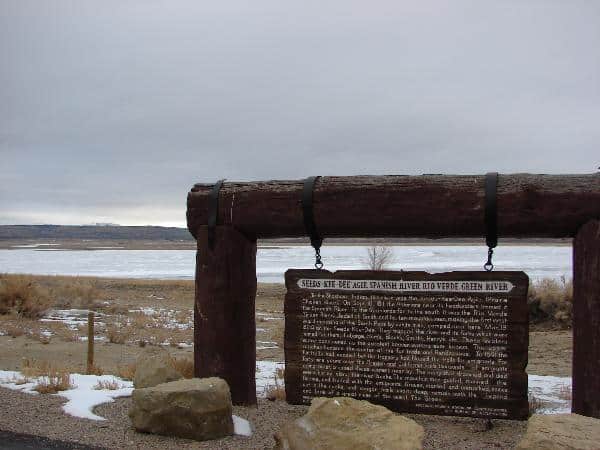
“To the Shoshone Indian, this river was the Seeds-Kee-Dee Agie (Prairie Chicken River). On Sept. 16 1811, the Astorians near it’s headwaters termed it the Spanish River. To the Spaniards, far to the south, it was the Rio Verde (Green River). Jedediah Smith and his Mountain Men, making the first westward crossing of the south Pass by white men, camped near here Mar 19, 1824 on the Seeds-Kee-Dee. They trapped the river and its forks which were named for them: LaBarge, Ham’s, Black’s, Smith’s, Henry’s, etc. These waters were considered as the greatest beaver waters ever known. The upper reaches became the center of the fur trade and the Rendezvous. In 1841 the fur trade ceased, but the trappers had blazed the trails for the emigrants. For forty-nine years over the Oregon and California trails, thousands of emigrants going west, crossed these waters nearby. The many that drowned and died were buried along the river banks. The Mountain Men guided, manned the ferries and traded with the emigrants. Graves, marked and unmarked, names cut in the rocks and wagon trails worn deep remain with the legend and lore of a great river of the West – The Green.”

327c23a5-9c55-4d35-b6f3-763dc6e2f1b2
645ed6a4-cd80-4a19-be61-55e79df39ac0

MGM Grand Las Vegas

27 Friday Oct 2017

Posted by Jacob Barlow in Uncategorized

≈ 1 Comment

Tags

Largest, Las Vegas, Las Vegas Strip

MGM Grand Las Vegas

The MGM Grand Las Vegas (formerly Marina and MGM-Marina) is a hotel and casino located on the Las Vegas Strip in Paradise, Nevada. The MGM Grand is the largest single hotel in the United States with 6,852 rooms. It is also the third-largest hotel complex in the world by number of rooms and second-largest hotel resort complex in the United States behind the combined The Venetian and The Palazzo. When it opened in 1993, the MGM Grand was the largest hotel complex in the world.

31ce949c-69b2-4311-a273-d715ec81524e

Famous for the huge lion outside (The Largest Bronze Sculpture in the western hemisphere) the MGM is one of the hotel/casinos on the Las Vegas Strip.

All Is Well Statue

27 Friday Oct 2017

Posted by Jacob Barlow in Uncategorized

≈ Leave a comment

2017-09-10 18.01.02

Abiding faith in God and the determination to protect their freedom to worship led the Mormon pioneers to seek refuge in an unsettled mountain region. This Monument is a tribute not only to those who gave their lives on the trail across the plains, but to those who endured countless trials and privations and loved to make their new desert home blossom as a rose.

The Mormon pioneers moved slowly across nearly 1,400 miles of wilderness. With sweat and faith and fortitude they built hundreds of communities in the mountain vastness. With patient care, they planted and nourished the soil. As the land responded, a new Christian way of life emerged in the wilderness. The faith they embraced lives on today. Encouraging and strengthening a growing number of loves in many lands.

Between 1856 and 1860 some 3,000 handcart pioneers walked from Iowa to the Salt Lake Valley, pushing and pulling two-wheeled carts loaded with their belongings. Some 250 lost their lives on the handcart trail when trapped by blizzards in high mountain passes. The survivors helped build thriving communities in the mountains with a way of life offering eternal hope to all mankind.

Located at the Park/Memorial Garden for Brigham Young’s grave.

Location: 1st Avenue between State & A Street
On June 1, 1974, an eight-foot bronze statue was unveiled at the small Brigham Young Cemetery on 1st Avenue. Sculpted by Edward J. Fraughton, the monument depicts a pioneer father, mother and daughter in an embrace. The plaque is entitled “All is Well”

See other historic markers in the series on this page for SUP Markers.

2017-09-10 18.01.29

2017-09-10 18.01.21

2017-09-10 18.00.56

Provoans Built First Railroad in 1873

27 Friday Oct 2017

Posted by Jacob Barlow in Uncategorized

≈ 2 Comments

Tags

Provo, Railroad, Railroad Depots, utah, utah county

2017-10-07 11.20.09

Local Citizens Financed and Built Provo’s First Railroad in 1873

The Union Pacific Railroad disappointed Brigham Young when it bypassed Salt Lake City and went through Ogden and around the north end of the Great Salt Lake.

Undaunted, Young supervised the organization of the Utah Central Railroad Company to span the 37 miles between Ogden and Salt Lake City.  The last spike on this railway was driven on January 10, 1870.

A year after the completion of the Utah Central Railroad, local investors incorporated the Utah Southern Railroad, which was initially to run the 65 miles from Salt Lake City to Payson.  Officials broke ground for the railroad on May 1, 1871, and Brigham Young drove the first spike a month later.  When construction reached Utah Valley in 1872, Young encouraged the people to provide cash, labor and ties in exchange for stock in the railroad.

Provo City gave the railroad a right of way along 600 South in 1872, and in 1873 City leaders selected a location for a depot where 600 South intersects what is now University Avenue.  On that site, the company erected a frame warehouse measuring 21 by 64 feet on the south side of the tracks and a ticket office on the north side.

Workmen completed the railroad to Provo late in November, 1873.  The first official trail from Salt Lake City arrived on November 24, the day of the opening celebration.  About 2,000 people gathered at the depot to hear music played by the Provo Brass Band and the speeches of church and civic leaders.

Today’s UTA FrontRunner station and transportation terminal is located near this same site.

This plaque is located in Ron Last Park in Provo and is part of this series of plaques.

2017-10-07 11.20.26

2014-03-07 15.50.27

Provo’s First Cooperative Opened in 1869

27 Friday Oct 2017

Posted by Jacob Barlow in Uncategorized

≈ 3 Comments

Tags

Co-op, Historic Buildings, Provo, utah, utah county, ZCMI

2017-10-07 11.16.55

Provo Citizens Opened One of Utah’s First Co-operative Retail Stores in 1869

As the transcontinental railroad neared completion late in 1868, leaders of The Church of Jesus Christ of Latter-day Saints worried that it might undermine self-sufficiency in Utah and increase the power of Gentile merchants.  Brigham Young proposed co-operative merchandising as an alternative to “trading with the enemy.”

He initiated the formation of a wholesale house, Zions Co-operative Mercantile Institution, in Salt Lake City.  Young hoped this wholesale outlet would provide inexpensive merchandise to co-operative stores owned by local stockholders in every Utah community.

The people of Provo established one of the first co-operative stores early in 1869.  Kimball & Lawrence, a Mormon firm located in Salt Lake City, had just built a two-story brick building where the Knight Block stands today on the northeast corner of University Avenue and Center Street.

The firm realized that they would lose most of their customers to the co-operative movement, so they sold the building and its stock at cost to the Provo Co-operative Mercantile Institution, called by locals the “East Co-op.”

The Co-op did well and doubled in size in 1880 by building an addition onto the east side of the store.  The firm continued to show a profit until 1887 when earnings began to fall.  By 1895, the co-operative store was bankrupt partly because of extending too much credit.

It successfully reopened two years later, and Jesse Knight bought the property from Z.C.M.I. in 1898.  His interests ran the store until 1900, when Knight closed out the stock, tore down the building, and built the present Knight Block, one of the most beloved buildings in the city.

See also:

  • Old Z.C.M.I Building
  • Provo West Co-op

This plaque is located in Ron Last Park in Provo and is part of this series of plaques.

2017-10-07 11.17.07
2014-03-07 15.48.37

Paul Ream Wilderness Park

26 Thursday Oct 2017

Posted by Jacob Barlow in Uncategorized

≈ 3 Comments

Tags

Parks, Provo, Provo River, Provo River Parkway Trail, utah, utah county

2017-08-26 18.30.44

Paul Ream Wilderness Park is an awesome park in Provo along the Provo River.   It feels like you’re up in the mountains in the middle of the city.

Related posts:

  • Parks in Provo
  • Provo
  • Provo Historic Series #16
  • Provo River Parkway Trail

2017-08-26 18.32.12

2017-08-26 18.33.01

2017-08-26 18.33.38

2017-08-26 18.33.46

2017-08-26 18.35.23

2017-08-26 18.35.27

2017-08-26 18.36.34

2017-08-26 18.36.45

2017-08-26 18.36.50

2017-08-26 18.37.27

2017-08-26 18.39.53

2017-08-26 18.39.56

2017-08-26 18.45.23

2017-08-26 18.45.29


Provo’s First Colonizers Soon Moved from a River Site to Higher Ground

26 Thursday Oct 2017

Posted by Jacob Barlow in Uncategorized

≈ 3 Comments

2017-08-26 18.26.43

Provo’s First Colonizers Soon Moved from a River Site to Higher Ground

In September, 1849, only six months after Provo’s original colonizers had build Fort Utah near where I-15 today crosses the Provo River, Brigham Young told the colonists to move onto the slightly elevated land to the east where there was not as much alkali in the soil and where they would be safer from floods.

By the next April, only a year after the colonists had established Fort Utah, they began their very gradual relocation to Fort Provo about a mile east of Fort Utah in what is now North Park at 500 West and 500 North. Colonists used logs salvaged from their old cabins and the palisade around Fort Utah, as well as newly cut logs, to build cabins around a 1,500-foot square at the new site.

The doors and windows of the cabins faced the inside of the square, exactly as they had been at Firt Utah. Some settlers made portholes in their cabins facing outside for defense against the Indians. Inside the square, workmen built a 50-foot-long log structure which they used as a school, church and civic building.

Surveyors began mapping a town play south of the fort in the summer of 1850. They started with the northwest quarter, with the road west of the fort (now 500 West) as Main Street.

Like at Fort Utah,the settlers did not inhabit Fort Provo very long. That fall, settlers began moving out of the fort and occupied lots along Main Street. By the spring of 1852, most of the colonists had moved to lots in town. Fort Provo stood almost deserted by that fall, but the land where it once stood has since been used for a variety of very important public uses, one being an ice skating rink.

This plaque is part of this series of historic plaques and is located in Riverside Park and along the Provo River Trail in Provo.


2017-08-26 18.26.52

Provo’s Early Colonists Were Caught Between Two Warring Indian Bands

26 Thursday Oct 2017

Posted by Jacob Barlow in Uncategorized

≈ 4 Comments

2017-08-26 18.29.29

Provo’s Early Colonists Were Caught Between Two Warring Indian Bands

Early on the morning of April 12, 1849, less than two weeks after Mormon colonists arrived in Utah Valley, a frenzied group of Shoshone warriors whipped their ponies down the west side of what is now Grandview Hill and raced toward the sleeping Ute camp a half mile west of Provo’s first fort, located where I-15 today crosses the Provo River.

Screaming shrill war whoops and shooting their guns in the air, Chief Wanship and his Shoshones ran off the Ute horse herd tethered just outside the village. Startled Ute men ran from their lodges with rifles or bows in hand and launched a hurried counterattack to drive off the plundering Shoshones.

Several Ute men, including Little Chief’s son, received wounds, but nobody on either side was killed. Reckless shooting, however killed two horses and wounded two others. In the end, the Shoshones rode off with about 28 Ute horses and a few animals belonging to the colonists.

This raid placed the settlers in a difficult situation. If they sided with one band, their actions would offend the other band. Mormon leaders did try, unsuccessfully to negotiate the return of the stolen horses.

Little Chief borrowed horses from another band of Utah Valley Utes and mounted an effort to recover the horses by force or guile. This attempt proved to be costly for the colonists and the Utes. Little Chief, who had been relatively peaceful and cooperative, and his son died on this expedition. Ope-Carry, who was more volatile and warlike, replaced the former chief. Partially as a result of this, war between the Utes and the settlers broke out the following February.

This plaque is part of this series of historic plaques and is located in Paul Ream Wilderness Park and along the Provo River Trail in Provo.

2017-08-26 18.29.34

Riverside Park

25 Wednesday Oct 2017

Posted by Jacob Barlow in Uncategorized

≈ 4 Comments

Tags

Parks, Provo, utah, utah county

2017-08-26 18.22.30

Riverside park in Provo and along the Provo River Parkway Trail.

See also:

  • Parks in Provo
  • Provo
  • Provo Historic Series #17
  • Provo River Parkway Trail

2017-08-26 18.18.13

2017-08-26 18.20.34

2017-08-26 18.20.39

2017-08-26 18.17.58
2017-08-26 18.22.21

2017-08-26 18.26.43
2017-08-26 18.26.52

2017-08-26 18.29.29
2017-08-26 18.29.34

Historic Homes in Lehi

25 Wednesday Oct 2017

Posted by Jacob Barlow in Uncategorized

≈ 2 Comments

Tags

Historic Homes, Lehi, utah, utah county

Historic homes located in Lehi, Utah.

  • Dr. Elmo and Rhea Eddington House
  • James Gardner House
  • John Austin Cabin
  • John Smith House
  • Samuel Goodwin House
  • Thomas Austin House
  • Thomas R. Cutler Mansion
  • Thomas Webb House
← Older posts
Newer posts →

Follow Jacob

Follow Jacob

Come wander with me on Youtube.

Blog Stats

  • 2,098,635 hits

Social and Other Links

BarlowLinks.com

Recent Posts

  • Scout Monument
  • Provo High School Seminary Building
  • 821 E 100 S
  • 820 E 100 S
  • 817-819 E 100 S

Archives

Loading Comments...