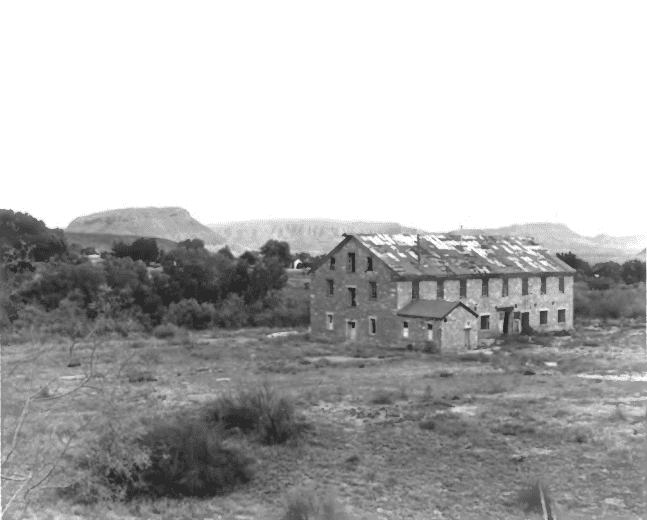
• About JacobBarlow.com
  • Best Mapping Site
  • D.U.P. Markers
  • Doors
  • External and Referral Links
  • Geocaching
  • Historic Marker Map
  • Movie/TV Show Filming Locations
  • Oldest in Utah
  • Other Travels
  • S.U.P. Markers
  • Utah Cities and Places.
  • Utah Treasure Hunt

JacobBarlow.com

~ Exploring with Jacob Barlow

JacobBarlow.com

Tag Archives: Washington

Nisson Park

07 Thursday Dec 2017

Posted by Jacob Barlow in Uncategorized

≈ 3 Comments

Tags

Historic Markers, Parks, utah, Washington, Washington County

picture01march08-010

Nisson Park in Washington, Utah.

Willard O. Nisson Park opened in May of 1999. Serving as a gateway to the city with the magnificent water wheel feature, Nisson Park also has a covered pavilion, a playground area, basketball hoops, a shaded walking path with picnic tables, restrooms and a large playing field.

There are some historic plaques on the main sign with the water wheel with the following information:

Washington City 1857

Washington City was founded by 38 southern families in the spring of 1857. Brigham Young called these families to serve on a mission to grow cotton in an area explored by John D. Lee in 1852. The mission was called the Cotton or Southern Mission. Brigham Young knew that southerners knew how to grow or at least had seen cotton grown. The city laid out on the 6 or 7 of May and the officials for the city’s operation were elected. Robert D. Covington was selected as the religious branch president, Harrison Pierce (Pearce) first counselor, and Jonathan R. Regeon (James B. Reagan) second counselor, Wm. R. Slade and James D. McCullough as Justices of the Peace, James Matthew and John Hawley as constables, Wm. Young and Joseph Adair as fence viewers, G.R.Coley was stray pound keeper, and Wm. R. Slade, Geo. Hawley and G.W. Spencer as school trustees. They immediately started to dig ditches, clear land and build a dam on the Rio Virgin so that they could plat crops. Cotton and corn were the main crops planted that first summer. Since they were Southerners they started to call thei new home “Dixie.” This name soon spread to the rest of the area so Washington City is Utah’s Dixie birthplace.

The area where the Willard O. Nisson park now stands was used as a campground in the latter part of the 1800’s. It was known as camp Washington and as Hall’s campground or pasture. Calvin Hall was the owner and operator of the campground. This provided for a place where visitors could come and stay in the small wooden cabins that were located on the property He also had a store located on the southeast corner of 200 W. and Telegraph St. This campground was the first place on Washington that had drinking water delivered in a pipe. A pipe was run from the northeast corner of 200 N. and 200 E. known as Hal’s Head House. This provided clean water to the campground. The water system to provide water to the homes in Washington was built in 1931.

The Antone and Leroy Nisson Families wanted to honor their father, Willard O. Nisson so they arranged for the building of this park. Through an exchange of properties, this property became available to that Washington City could construct this facility. Willard was known as a great schoolteacher, school principal, city mayor, and a talented musician. Willard’s sister Annie, the wife of Hans Peter Iverson, also came to Washington at this time. The Willard Nisson family home was located on the northwest corner of Main St. and Telegraph St.

2014-03-01 10.27.59

2014-03-01 10.28.03

2014-03-01 10.28.09
2014-03-01 10.28.15
2014-03-01 10.30.48

Telegraph Street

When Washington was laid out in May, 1857, there was not a street named or located where Telegraph Street is today. It was not until the resurvey of January, 1873, ordered by Wm. Snow, Judge of the Probate Court dated December, 1872, that Telegraph Street was shown on a city map. The Telegraph was completed between St. George and Logan, Utah on January 10, 1867, and the wire for the telegraph was located about where Telegraph Street is today; therefore the name Telegraph Street.

2014-03-01 10.27.49

Millcreek Mills

Machine Creek was the original name of Millcreek. John M. Chidester sold the water rights from Machine Creek to Brigham Young in 1864 so that the cotton factory could be built. It must have been after all of the mills were built along the creek that the name Millcreek came into existence. There were at least 8 mills built along the creek: #1 James Richey’s cotton gin was built in May, 1858. The first cotton gin built in the area. #2 Thomas W. Smith’s corn cracker mill was built in 1857 about halfway between Telegraph Street and the mouth of Millcreek where it enters the Rio Virgin. #3 Theodore Turley had a gristmill a few hundred yards below where the cotton factory is. John D. Lee purchased this mill and later sold it to Henry Barney of Grafton before 1860. #4 John D. Lee’s grist and lumber mill was finished Telegraph Street / Millcreek Mills Markers image. Click for full size. By Bill Kirchner, August 30, 2012 2. Telegraph Street / Millcreek Mills Markers in the fall of 1861 on the east side of the reek near the Turley’s mill site. #5 Snow’s gristmill on the west side of the creek opposite Jon D. Lee’s mill was built in 1866. #6 Hawley’s cane mill near the mouth of Millcreek was built before 1859. This mill was obtained by John D. Lee and his new replacement mill #7 was finished in September 1859. #8 The Cotton Factory was started to be built in 1865 and completely finished in 1870.

2014-03-01 10.30.46

There is also a “Pioneer Cotton Mills” historic marker with the following text:

As early as 1851 cotton was raised in northern Utah. In 1855 it was cultivated on a small scale at Santa Clara, nine miles west of here. In 1864 the nearby communities had 140 acres under cultivation, and the product was said “to be equal in every way to that grown in Tennessee.” The first extensive manufacture of cotton cloth was begun in 1865 when a cooperative cotton factory, organized by Brigham Young, was established immediately south of this marker. Machinery was freighted from the Missouri River, more than 1300 miles away. Shortly after the opening of the factory, equipment to manufacture woolen cloth was also installed, the wool being provided from large flocks of sheep, also operated on a church cooperative basis. The cotton industry flourished surprisingly for a time, partly due to Civil War interference with planters in the south. Part of the raw product went to California and some was freighted to New York where it sold as high as $1.90 a pound. After the cotton industry revived in the south, following the close of the war, the industry in Utah was abandoned.

2014-03-01 10.28.21

Harrisburg Residents

26 Wednesday Apr 2017

Posted by Jacob Barlow in Uncategorized

≈ 1 Comment

Tags

Harrisburg, historic, Historic Buildings, Historic Homes, Historic Markers, Leeds, Silver Reef, SUP, utah, Washington, Washington County

2017-03-19 16.02.02

HARRISBURG RESIDENTS
Named here are the Heads of the Families who settled in Harrisburg between 1859 and 1928:
1859
Moses Harris
1860
James Lewis Hosea Stout
1862
William Leany Dr. Priddy Meeks John Brimhall
Orson Adams Elijah K. Fuller Samuel Hamilton
William Robb Rufus Allen Allen J. Stout
Mosiah L. Hancock Alfred J. Randall
1863
Willard G. McMullen Samuel Gould John Newton
David Ellsworth John McCleve Allen Taylor
William Taylor

1865
Henry E. Harrington Milton Daily Wilson Daily
Thomas Adair Willbur Earl William Stirling
AL Carpenter Jerome Asa
Robert Richardson Frank Owens

See other historic markers in the series on this page for SUP Markers.

A Tale of Three Towns

26 Wednesday Apr 2017

Posted by Jacob Barlow in Uncategorized

≈ 3 Comments

Tags

Harrisburg, Historic Markers, Leeds, Silver Reef, utah, Washington, Washington County

2017-03-19 15.47.44

A Tale of Three Towns

The history of three towns—Harrisburg, Silver Reef, and Leeds—is
intricately connected. Harrisburg and Silver Reef are ghost towns today, while Leeds persists. Like many locations in the arid west, water and its availability and accessibility was the determining factor in whether a town lived or withered away.

Harrisburg

The first settlement in the area was Harrisburg, founded in 1861 by Moses Harris and a few Mormon families who settled along Quail Creek. Despite their efforts in digging a 5-mile-long irrigation canal along what is now known as Leeds Creek, growth was hampered by rocky soil and limited land available for farming. By 1876 Harrisburg was losing population and essentially failing. Today, remnants of a few pioneer homes and the restored Adams House are all that remain of Historic Harrisburg.

Silver Reef

About the same time Leeds was settled, silver was discovered on the White Reef. This reef, an upturned sandstone ledge, parallels I-15 from Harrisburg to a point north of Leeds. Miners and immigrants, including many of Irish, Cornish, and Chinese origin, rushed to the area with the hope of making their fortunes. The boomtown of Silver Reef sprang up about a mile north of Leeds, and by 1878 was a considerably larger community than either diminishing Harrisburg or the growing farming community of Leeds. At its height, Silver Reef boasted nearly a dozen mines and six ore processing mills, plus retail stores, saloons, hotels, banks, a school, Wells Fargo express office, theater company, and other urban amenities. Leeds and Silver Reef were a study in contrasts. Despite great differences in ethnicity, religion, and culture, the mining boomtown and its agricultural neighbor formed a mutually dependent relationship. The miners at Silver Reef were sustained by produce from Leeds, and Leeds farmers flourished with cash from the miners for their crops. By 1900 Silver Reef had died as the most easily accessible silver ore had been mined and the price of silver plummeted; however, the farming community of Leeds survived.

Leeds

By 1867 the Harrisburg pioneers realized that a place called “Road Valley,” just to the north, was more suitable for diverting water and cultivating farmland. Amidst controversy, but with direction from Mormon leader Erastus Snow, many families moved from Harrisburg to Road Valley. An irrigation ditch was dug and water was brought to the site. The town was organized on December 1, 1867, and named Bennington, in honor of the town’s bishop, Benjamin Stringham. Bishop Stringham later requested that the town be named after Leeds, England, where he had served as a Mormon missionary. In May of 1869, Bennington became Leeds.(*)

2017-03-19 15.49.27

Gardeners Club

07 Monday Nov 2016

Posted by Jacob Barlow in Uncategorized

≈ 1 Comment

Tags

historic, Historic Buildings, St. George, utah, Washington

2013-04-06-19-22-45

(*)This building was built in 1863 by J. E. Johnson, St. George’s first horticulturist, and members of the Gardeners’ Club. It served as a meeting place for the club and was never used as a home. It is one of the oldest public buildings still in use in St. George.

Around 1869, advanced or special courses were given by Richard Horton in the Gardener’s Club Hall.

The Gardeners’ Club is said to be the oldest pioneer building still standing in St. George. It was built in 1867 on land reported to have been donated by Joseph E. Johnson, whose property it adjoined. Members of the club made their own adobes and took their own teams and wagons to the Pine Valley sawmill to secure the lumber for building the small structure for their meeting place.

When the first settlers came to St. George in 1861, they were instructed by Brigham Young to explore the region’s agricultural possibilities so that the colony might become self-sufficient. Noted horticulturist Walter E. Dodge of Santa Clara was joined by Luther Hemenway, J. E. Johnson and others in cooperative efforts to establish and improve Dixie’s crops. Johnson published a newspaper, The Pomologist, to encourage horticulture, and the club staged displays of agricultural products, giving ribbons to the winners, in what must have been the forerunner of the county fair.

It is difficult for us to visualize this small building as the center of the village’s social and civic life until the completion of the Social Hall across the street. However, plays were held here, as were receptions, meetings and fairs. It even welcomed dances, but since space was so limited, a young man purchasing a ticket received a number and was only allowed to take his partner onto the floor when his number was called.

Eventually the building was deeded to James Pace and then to Sheriff Hardy, in whose family it remained until the Pace family secured it again and began the restoration of the corner.

The Gardeners’ Club stands today in the complex known as Ancestor Square and is used for a boutiqe shop. It remains much as it was at the time of its construction. It is a lasting memorial to the workmanship our ancestors believed in doing.

2013-04-06-19-23-10
2013-04-06-19-41-20-copy

Gates – McQuarrie House

12 Wednesday Oct 2016

Posted by Jacob Barlow in Uncategorized

≈ 1 Comment

Tags

historic, Historic Homes, St. George, utah, Washington, Washington County

2013-04-06-19-06-11

Gates – McQuarrie House

This property was one owned by Jacob Gates, the 2nd mayor if St. George.  Whether he constructed the Victorian house during his ownership (1876-1890) or it was built a little later, about 1893, by Hector & Ella McQuarrie is not certain.

What is known is that Ella rented some of the rooms to “drummers” (salesmen) travelling to St. George on business. Four of her six children were born here.

2013-04-06-19-06-15
2013-04-06-19-07-12

Courthouse and McQuarrie Memorial Museum

10 Monday Oct 2016

Posted by Jacob Barlow in Uncategorized

≈ 2 Comments

Tags

Courthouses, DUP, historic, History, museums, Pioneers, St. George, utah, Washington, Washington County

2013-04-06-18-36-28

Pioneer – Washington County – Courthouse

St. George was designated as the County Seat on January 14, 1883.   This building was begun in 1866 and completed in 1876.  It served the County government as offices, the 18-inch thick  walls housed the jail in the basement and school was held upstairs during the day and served as a courtroom by night.  Still reflecting days old are the original panes of glass alongside the entrance doors, the chandeliers, security vault, exterior cornice work, roof cupola dome and original murals of Zion and Grand Canyons in upstairs assembly room.

2013-04-06-18-37-01
2013-04-06-18-37-55

DUP Markers #14 and #298 are here.

2013-04-06-18-41-38
2013-04-06-18-41-46

The McQuarrie Memorial Museum (DUP Museum) is also here.

2013-04-06-18-43-31

Pioneer Museum –

This red brick building completed in 1938 was financed by Mrs. Horttense McQuarrie Odlum to house pioneer relics.  The addition was financed by Ferol McQuarrie Kincade in 1985.  Daughters of Utah pioneers volunteer their serves as decents for the museum.

2013-04-06-18-43-19
2013-04-06-18-43-37

Dino Cliffs Ruins

08 Saturday Oct 2016

Posted by Jacob Barlow in Uncategorized

≈ Leave a comment

Tags

Hiking, Ruins, St. George, utah, Washington, Washington County

2013-04-06-12-15-53

Out geocaching near the Dino Cliffs Trailhead just outside St George and found these cool ruins of round structures.

2013-04-06-12-18-59

2013-04-06-11-53-53

Pioneer Park

03 Monday Oct 2016

Posted by Jacob Barlow in Uncategorized

≈ 1 Comment

Tags

Parks, St. George, utah, Washington, Washington County

2013-04-06-18-46-21

Pioneer Park in St George is an amazing place to play on the red rocks and explore, there’s a tiny slot canyon to climb through and large white letters on the cliff saying “DIXIE.”

2013-04-05-16-27-54

2013-04-05-16-28-23

2013-04-05-16-28-43
2013-04-05-16-29-03
2013-04-05-16-32-06
2013-04-05-18-16-12

2017-05-13 15.12.24

2017-05-13 15.15.25

2017-05-13 15.32.40

2017-05-13 15.36.04
2017-05-13 15.33.42

Rockville, Utah

25 Thursday Aug 2016

Posted by Jacob Barlow in Uncategorized

≈ 3 Comments

Tags

Rockville, Springdale, utah, Washington, Washington County, Zion National Park

ROCKVILLE

Rockville Posts:

  • Rockville Bridge

Rockville lies just outside the park boundary for Zion National Park; the park entrance is located approximately 5 miles  northeast of the town.

Four miles southwest of Springdale. It was originally settled in late 1860 and early 1861 under the direction of Mormon Apostle Orson Pratt. The original name was Adventure but it was subsequently changed to Rockville because of the rocky soil and surroundings along the Virgin River.

Washington, Utah

02 Saturday Apr 2016

Posted by Jacob Barlow in Uncategorized

≈ 3 Comments

Tags

Hurricane, La Verkin, St. George, utah, Washington, Washington County

picture01march08-010

Washington is part of the St. George Metropolitan Area, also known as Utah’s Dixie because the Mormon pioneers that settled the St. George area came to the area to raise cotton, which was milled at the cotton mill in Washington. The population was 8,186 at the 2000 census, and 18,761 as of the 2010 Census. The city administration has tried to encourage the use of the name “Washington City” in recent years , relying on old pioneer documents from the 19th Century that use that term, but many cities haphazardly added “City” to early documents when it was never intended that the cities involved use “City” as part of their names. The U.S. Post Office lists “Washington, UT 84780.”

Washington Posts:

  • Covington Mansion
  • Nisson Park
  • Washington Cotton Factory


c79a0e44-ee31-4b1c-bb2c-b3e8b6cb06ee

← Older posts

Follow Jacob

Follow Jacob

Social and Other Links

BarlowLinks.com

Blog Stats

  • 269,979 hits

Recent Posts

  • Canyon Driving – Troll 2 Filming Location
  • Tule Springs
  • Jackson Square
  • 210 S State St
  • Historic Wheeler Survey Marker

Archives