Tags
Payson, Salem, spanish fork, utah, utah county, Woodland Hills
Woodland Hills is a city in Utah County, The population was 1,344 at the 2010 census.
As of the 2000 census, Woodland Hills had the highest median income in the state of Utah.


01 Tuesday Jul 2014
Posted in Uncategorized
Tags
Payson, Salem, spanish fork, utah, utah county, Woodland Hills
Woodland Hills is a city in Utah County, The population was 1,344 at the 2010 census.
As of the 2000 census, Woodland Hills had the highest median income in the state of Utah.
30 Monday Jun 2014
Posted in Uncategorized
Tags
historic, Mines, Payson, Salem, utah, utah county, Woodland Hills


Jay M. Haymond
Utah History Encyclopedia
The so-called Dream Mine is located east of Salem in Utah County. The mine founder, John H. Koyle, was born August 14, 1864 at Spanish Fork, Utah County. He married Emily Arvilla Holt 9 December 1884. They had four son and three daughters. At about age twenty-two, Koyle experienced a dream about lost livestock and other domestic matters. Gradually he became known as a visionary man. He grew to dream about a wide variety of subjects, including world affairs. Many of his predictions came true and earned him a following of faithful admirers.
His membership in the Mormon Church led him to serve a mission in 1888 to 1891 in the Southern States Mission. His dreams continued and he was known as a missionary with prophetic abilities. Following his missionary service, Koyle returned home to his wife and family to resume farming.
In August 1894 he experienced a dream in which he was visited by a figure from another world. The visitor carried him to a high mountain east of Koyle’s house and into the mountain, showing him the various strata and explaining the meaning of the minerals. The visitor showed Koyle an ancient “Nephite” mine with large rooms of mined-out ore bodies. The rooms contained treasure and artifacts of an extinct civilization. Koyle was instructed that he was to open a mine and extract gold for the welfare of “his” people. Specific instructions were given for the mine development leading to rich ore bodies. The riches would be found and released to him and his followers during a time of world crisis. The wealth would be spread to others through Koyle and the people organized around the mine. In this way the name “Relief Mine” was attached to the project. The heavenly messenger made it known that the wealth would not be available for “self gratification.” The dream was repeated for a total of three times. Koyle talked of his dream to friends and others for support. In 1909 the Koyle Mining Company was formed with 114,000 shares of stock issued at $1.00 per share.
Koyle’s dreams continued. He predicted the First World War and the economic crash of October, 1929. He foresaw “horseless carriages” bigger than railroad cars going down the road at great speeds. He especially received instruction on how to develop the mine. Plans included air shafts, escape ways and drainage tunnels. Instructions came to build a processing mill and storage bins for grain. By 1910, Koyle was appointed bishop of the Leland Ward in Spanish fork. The mining activities closely coupled with his church work attracted attention from the Mormon Church leaders. Apostle James E. Talmage, a geologist by training, came to look at the Dream Mine claims and could find no evidence that precious metals would ever be found in the strata being explored. The Mormon Church spoke out against the Koyle mine and associated activities and released John H. Koyle from the bishopric. However, Koyle’s ongoing success as a seer and visionary continued to attract supporters and money, including some members of the Mormon Church leadership. Koyle was getting a mixed message from the Church. For a time, Koyle moved some members of his family to Idaho to pursue farming and while there Koyle was appointed to another bishopric as a councilor, but released when the Mormon leadership learned of the appointment. He continued to attract opposition from the Church for the rest of his life. He negotiated a repudiation of his claims, in 1947 and then reversed himself almost immediately and was excommunicated from the Church 18 April 1948. John H. Koyle died 17 May 1949 in Payson.
The mine continued in fits and starts under the leadership of Quayle Dixon for another twenty-three years. In 1961, a new company, The Relief Mine Company, succeeded the Koyle Mining Company and continued to do the minimum $100 per claim annual assessment work. Little more can be said about the often promised Koyle Dream Mine.
See: Norman C. Pierce, The Dream Mine Story, Salt Lake City, 1972.
01 Friday Nov 2013
Posted in Uncategorized
Tags
Elk Ridge, Payson, Pond Town, Salem, spanish fork, utah, utah county, Woodland Hills


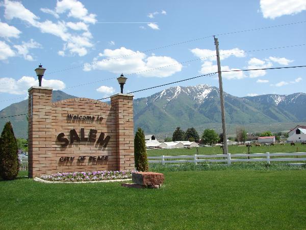
Salem, Utah is in Utah County between Payson and Spanish Fork, also near Elk Ridge and Woodland Hills.
The following is from pondtown.org:
Known as “Summer Spring” by the Indians, and “Pond Town” by early settlers, Salem, in Utah County, was finally named after the birthplace of Lyman Curtis to honor his contributions to the community.
The Indians appreciated the fact that the local springs bubbled up through sandy soil in a tree-shaded hollow, even in summer. In the spring of 1851 David Fairbanks and David Crockett discovered this same precious asset. Fairbanks had been assigned to Peteetneet Creek (Payson), where he was to become LDS bishop of the town. The two men continued to explore the area and found a large, clear stream flowing through a hollow. They realized that by damning the stream they could conserve the water that flowed out into swamplands. They soon moved their families and built the first dam, assisted by others from Payson who needed additional farmland. Some crops were harvested that year.
Winter and the threat of hostile Indians caused the families to return to Peteetneet, but “Pond Town” had a beginning with the dammed springs. In 1852 the two founders built a second and more secure dam, but by the next year the families had moved to Peteetneet and the new settlement was abandoned.
Settlers from nearby Palmyra, fighting drought and alkali salts in the soil, decided to start over at the abandoned Pond Town. George Wilson and his brothers purchased the Fairbanks-Crockett interest and they, along with eight other families, moved to the area in 1856. During that same year, Lyman Curtis, one of the original company of pioneers to enter Salt Lake Valley, joined in the new development with four of his sons.
In the next few years two more dams and an irrigation system were developed. Homes were built adjoining one another for protection against Indian attacks. The homes were constructed of adobe brick and lumber from nearby canyons. The fort homes were used until 1870 when the Indian danger had been reduced. Settlers began moving into the town, which was laid out in five-acre blocks. As was common throughout Utah, homes and barns were built inside the town, with fields and grazing area outside. Boys herded cattle on “common grounds.”
The completion of the Salem Canal in 1869 brought irrigation water from the Spanish Fork River to Salem. Lyman Curtis, who had experience with irrigation in Santa Clara, directed the project to completion. The canal was eight miles long and took two and one-half years to build. Additional water was brought to the area by the Strawberry Valley Irrigation Project, completed in 1916.
Popular crops were wheat and other grains, as well as tomatoes and peas for the Del Monte food-processing plant, located between Salem and Spanish Fork. Beginning in 1891, sugar beets were grown extensively for the factories throughout Utah Valley. A “beet vacation” allowed boys out of school to assist in harvesting. Many farmers specialized in growing garden produce or in raising poultry. Local ranchers had grazing rights and permits in the nearby national forests, in Strawberry Valley, and in privately owned property in Loafer Canyon.
In the nineteenth century blacksmithing was a much needed service, and there also were immigrants skilled in masonry, milling, and cobblery. Sawmills and shingle mills, molasses producing factories, creameries, and confectioneries have supported families and provided for community needs.
The LDS Church started a co-op in Salem in the late 1860s; it operated largely on the barter system until it was discontinued in 1897. Several small stores were operated for short periods of time. In 1908 the Salem Mercantile Company was started by the James Peter Christensen family, which operated it until 1969. For many years the “Merc” used the barter system and issued scrip. In 1946 Melvin R. Hanks started another grocery business on Main Street. Later continued by two sons, this family business also thrived. There were a number of service stations along U.S. Highway 91, and a motel. Through the years the town also had a drugstore, barber shop, and a saloon. A few businesses are still clustered along the highway.
The LDS Provo Stake served Pond Town’s religious needs until Salem Ward was created in 1877. A red brick church was completed in 1898, remodeled in 1938, and replaced in 1972. The one ward was divided in 1956, and currently there are two local LDS stakes.
Education was always important to the settlers, and parents made arrangements for their children to be taught, first in homes and then in a log schoolroom. Several small buildings were used for school, church, and public meetings until the church meetinghouse was built in 1898; it was followed by a new brick school built in 1907.
The “Dream Mine” of John Hyrum Koyle, as well as the pond, became synonymous with Salem. Koyle dreamed of a rich ore mine on the hillside and set out to bring his dream to fruition. Selling shares in the venture, Koyle was able to have a deep shaft dug, but ore was never found.
Salem was incorporated as a town in 1886, and fourteen presidents and boards of trustees served until 1920, at which time the first mayor began his term in office.
Throughout its history, the citizens of Salem have been hardworking, neighborly, and flexible, adapting to the changes time has required of them.
Related Posts:


Serendipity the Dragon
01 Friday Nov 2013
Posted in Uncategorized
Tags

Elk Ridge is with Woodland Hills up in the hills south of Salem and Payson.
A History of Elk Ridge*:
Elk Ridge was built on the 1800 acre Goosenest Ranch nestled against Mount Loafer in the south end of Utah County. The ranch got its name from an area of land in the west end of Elk Ridge known as „The Goosenest”. The geese came to nest in this area for many years. It is a natural basin that had been improved upon to hold water that flowed down from Payson Canyon. However, after strengthening the dam and building a canal that ran from the reservoir to Payson, those early builders were most disappointed because the reservoir would not hold water. The water entered the basin and within a few days would disappear; travel underground and show up in the fields two or three miles to the north. Their beautiful project was a failure. Until recently, Payson still would send the high water down to the Goosenest and it would still disappear. The course it would take has cut a very deep wash through the Goosenest area. It is interesting that the first road to access Payson Canyon was up through this Goosenest area.


The original ranch was a 160 acre parcel homesteaded by James Fayette Shuler. James married Mary Ann Olive Warthen of Council Bluffs, Iowa. After James died in 1923, the land went to Mary Ann. She died in 1936 leaving the ranch to her five children. Dave, the youngest of the children bought out the interests of the other heirs. He later bought other ranches that surrounded his and increased his ranch to a total of 1800 acres. Some of the other ranches purchased were: the Huber Ranch, the Herman Tagge Ranch, the Dave Curtis Ranch, the John Dixon Ranch, the PerryJackman Ranch, and the Joe Barrett Ranch. Dave and Erma Shuler lived in Payson until 1947. They traveled back and forth to take care of the many duties of farming this large dry-land ranch. In 1947 they sold their home in Payson and moved to the ranch so that Dave could be closer to his work. In 1948 Dave‟s son Hal married Carolyn Davis of Salem and built a small two-room house behind the old ranch house in order to help his father with the huge task of putting up acres and acres of dry-land hay and wheat. Hal graduated from BYU in agronomy and soon became the manager of the ranch. The ranch had miles of fences to build and keep in repair. The amount of damage done to them by the deer and elk during the winter was amazing. There was a large herd of cattle to be fed during the winter and looked after during the summer. Some years the ranch had large herds of pigs, over 100, that would wander the foothills eating last year‟s acorns and eating from the many pig feeders that were stationed at the springs located about three miles from the ranch house. The ranch house itself has an interesting history. The Shuler‟s were kept busy remodeling and repairing the frame house that was once built and owned by Jesse Knight, a famous man in the early days of Utah County. It had been on Mr. Knight‟s farm in West Mountain (west of Payson). It was moved to the ranch by Herman Tagge and at that time was the only home at the south end of Utah Valley. Dave and Erma Shuler remodeled the home and added the rock work. It now sits on the west boundary of Elk Ridge and is owned by Hal Shuler.

Dave Shuler died in 1965 and his once famous Goosenest Ranch was divided among his five children and his wife, Erma. His son, Hal, bought a few hundred acres from his father and after the death of his father bought some of the land that was owned by his two sisters. The land owned by his brother Howard was sold to Mr. Jim Winterton of Provo. Mr. Winterton and Dave‟s son, Keith “Bish”, started the county subdivision of Salem Hills. Roy Broadbent, manager of the First Security bank in Payson, shared the ideas and aspirations of the developers and made it possible for them to proceed with the development of Salem Hills. The original water rights were agricultural farm water rights and in 1970 were transferred into culinary rights to be taken from the underground source of a well. Keith Shuler drilled three wells that provided enough water for the initial development and the county neighborhood of Salem Hills was started. In 1970 a dirt road wound its way up the hillside and the very first homes built were condominiums. The idea and plan was to rent out the condos while homes were being built. Sewer lines were installed, with open ponds located at the area of the present roads of Star LN and Olympic LN, the utilities were buried and parcels of land were sold. The Goosenest Ranch where the deer and the elk had roamed undisturbed and where acres of alfalfa and wheat made a patchwork pattern of this end of the valley was now given way to homes and people. The first home completed in Salem Hills was the Gary and Rhonda Proctor home located at 62 South Clark Lane. They moved here from Aurora, Colorado, into one of the condominiums in 1972. Their home on Clark Lane was finished in June of 1973 and they moved in at that time. The Proctors still live here but over the years have moved to a home located on Highland Circle. In September, 1973, the dirt roads were improved to oil, sprinkled with gravel. Most of the roads were built on existing grades with no road base. Today, we face the problem associated with that method of road construction as we see heavy loads cause failures in certain areas. The first time the snow plow came through, the gravel and oil ended up by the side of the road with the snow. The winter of 1975-76 will be remembered by the twenty families living here as a very severe winter with a great deal of snow. The roads were torn up again and the families were snowed in several times. During the summer of 1976 the main road was asphalted and it was not until 1978 when most of the streets received their asphalt surface. On May 31, 1973, a home owners association was formed to help govern the improvements and growth in the subdivision. When a lot was sold the buyer was assessed $2,000.00 for the water and sewer. Providing water for the residents was a problem from the very beginning. The original pumps did not have an automatic shut off and any time the electrical power went off, someone had to turn the pumps back on manually. During the winter months, residents had to put on snow shoes and hike to the pumps to turn them back on.
The original water tank was installed in 1972 and held 33,000 gallons of water. In 1977, two additional 40,000 gallon tanks were installed in the upper area of Salem Hills. These tanks had been owned by the Fisher Brewery in Salt Lake City and were used to age beer – many jokes were made about the great water the residents now had. In 1982 a 500,000 gallon water tank was built and buried in the south hillside and in 1992 another 500,000 gallon tank was built and buried up on the mountain. All three of the small tanks have been moved and given to other people that have had need for them. The development soon approached the time when it had 100 residents living within its boundaries and according to Utah County rules the development had to incorporate into a city. On December 22, 1976, the Salem Hills development was incorporated into the town of Salem Hills. The first Council members of the newly formed town were: Kenneth Harris, Gary Proctor, Glen Royle, Dale Bigler, and John Peterson. Ken Harris was appointed the Mayor and Zola Hales was appointed the City Recorder. These citizens were appointed for a one-year term by the County Commission. The first regular election was held in 1978. There was much work ahead and many challenges to be addressed. The Council members and other residents spent many hours working on the numerous charters and plans needed for incorporation. A Planning Commission and a Board of Adjustment were organized and members appointed to fill those positions. Ed Knolton was the first Building Inspector and he still lives here in the home he built in the 70‟s. Contracts were entered into with Utah County for police protection and with Salem and Payson for fire and ambulance service. Because of the confusion with the town of Salem, Salem Hills was changed to Elk Ridge at a special meeting of the town by a vote of the people on June 15, 1978. This name was very appropriate because the elk could still be seen nearly every winter morning and evening as they journeyed from their mountain home wandering through the town to graze in the fields and orchards at the north area of the community. The children attended school in Payson and the bus, in the early days would pick them up at the spot called the “Gravel Pit”, near the three-way stop on Goosenest and Elk Ridge DR. By September 1974, there were 14 children attending school so the bus came up the hill. In 1979 a well was drilled at the north end of Elk Ridge. The well could pump 350 gallons of water per minute and was 950 feet deep. The cost to pump the water to the upper tanks was very expensive so at that time was rarely used. Two other small wells were drilled in Loafer Canyon in 1978 and 1979. In 1993, a new well was drilled in the canyon at the extreme south end of Elk Ridge within the private gated area. It supplies the community with an exceptional amount of water that once brought to the surface has gravity flow to the storage tanks. By the summer of 1980, the population was 381 and there were 99 homes in Elk Ridge. The first youth baseball league was organized that summer. During the summer of 1981, work was started on the seven acre site that was set aside for the city park. This park site was donated by the developers Hal Shuler, Keith Shuler, and Jim Winterton. The baseball diamond was graded by the Utah National Guard Engineering Unit based in Springville. The labor and equipment was donated as a work project and the town paid for the lunch and fuel. Council meetings were held in the homes of the Council members until a city building was completed in 1984. We received a grant from the government to help with the new city building, however; many, many more hours were donated by volunteers to complete the building. Between1976 and 1981 several changes were made to the City Council. In the November 1981 election, a new slate of officers was elected. The mayor was John Peterson and the Council consisted of Cregg Ingram, Hal Shuler, Wayne Shute, and John Thomas. The new council faced many problems common to a growing city. The most critical problem was sufficient water storage. During the heat of the summer, residents experienced a shortage of water on many occasions. During the peak hourly flow, without the wells pumping, water storage was depleted in one hour. In March 1982, the city applied to the Utah Board of Drinking water and Water Resources for financial assistance in increasing the water storage capacity. The summer of 1987 saw the completion of the pavilion, which was almost, completely, done by the residents of Elk Ridge. We did receive a matching grant from the government to help build the pavilion. In September 1984, the first LDS chapel was completed. On May 28, 1988, the Gladstan Golf Course was opened. Elk Ridge donated land to Payson to help build the golf course. In the fall of 1985, Cable TV was introduced to part of the city. In June of 1988, Elk Ridge and Salem completed their combined new sewer plant. Building of homes was slow, after seventeen years of growth, only 157 had been built by 1989. Between 1984 and 1990 the Fire Department became well organized. Regular training sessions were held and equipment and tools were purchased. Elk Ridge was tied into the emergency “911” phone system. The City Council and Fire Department sponsored a Fourth of July celebration each year. In the beginning, the Scouts would help organize a program and the Saturday morning breakfast was prepared and served by the Fire Department and EMS group. Races, a parade and various sporting activities, as well as, a carnival are a part of the celebration.
In 1990 the Census recorded a population in Elk Ridge of 771 people. By January, 1994 the town had grown to 230 homes. Presently in 2008, we have approximately 550 homes and an estimated population of 2,500 people.


Visit my list of places in Utah.