Tags
Eureka, Juab County, Mines, NRHP, utah

30 Thursday Apr 2026
Posted in Uncategorized
30 Tuesday Sep 2025
Posted in Uncategorized
Tags
Homestake Mine
The Homestake Mine is located in Clark County, Nevada and was added to the National Register of Historic Places (#85001601) on July 17, 1985.
30 Wednesday Nov 2022
Posted in Uncategorized
15 Saturday May 2021
Posted in Uncategorized
Tags

In the foothills above Springville, Utah near Little Rock Canyon is this little mine I came across. It doesn’t go too far but it’s still pretty cool.
N 40.18158 W 111.59434


Jerry Sermersheim added a plaque to the mine saying:
My name is Jerry Sermersheim, the true origin of the cave is not known at this time. My boyhood friend, Larry Rowland, and I first discovered it for ourselves as young children in 1950. We were neighbors living north east Springville at that time and often had fun hiking together in the mountains to the east of us. At that time we dubbed it to be known as “Golden Gate Cave” since some of the stones had a yellow/gold tint to them. Our young imaginations led us to believe there was gold to be had if we just had the means of getting to it.
Our local historian, Lee Taylor, has information that there are many similar excavations in the mountains along the Wasatch Front. It would be interesting to know more about these caves and the people who created them.
If you have information regarding such things I would be interested in meeting with you some time. My contact is: 801-367-3925. Jerry Sermersheim
PS:
short time ago I revisited the cave with one of my sons and his two daughters. To our dismay the cave had been inhabited by some person(s) that had no respect for nature and the beauties around us. They left the cave in a shambles of garbage and trash. We planned a rescue trip to clean up what these thoughtless people had left behind.
We ask you, as visitors, to follow the outdoor code: “Take only Pictures and Leave only Footprints.”
23 Wednesday Dec 2020
Posted in Uncategorized
Tags
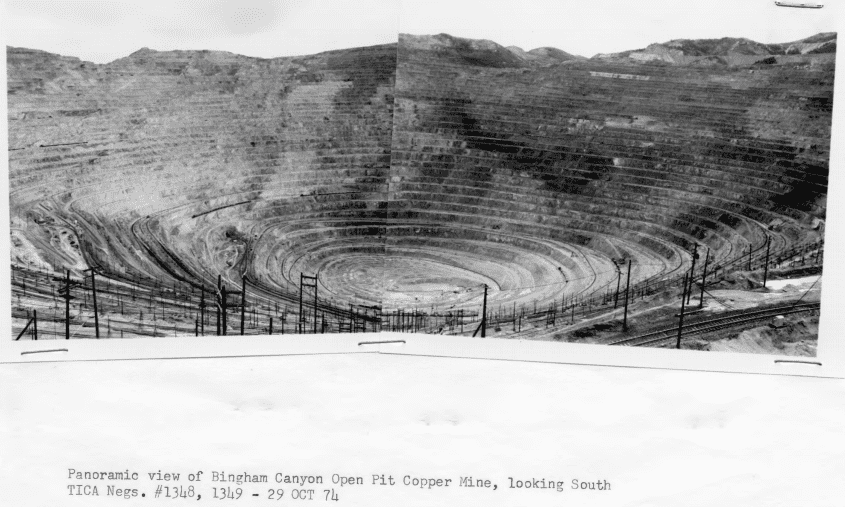
The Bingham Canyon Mine was the first open-pit copper mine in the world. Initiated in 1904, it remained the most productive of all the low-grade copper mines which soon appeared. Today it still yields about 14 percent of all U.S. copper production.
Bingham Canyon flourished as a scene of gold and silver mining from 1863 to 1893, In 1887 Colonel Enos A. Wall discovered and filed claim to the vast deposit of low-grade copper ore that was later to become the open pit mine. With the gold and silver mining still highly profitable, Wall’s efforts to finance a copper mining operation were unsuccessful, and in 1903 he sold the property on option to a group of investors who had become interested in the prospect through the efforts of Daniel C. Jackling, Jackling had previously investigated the property and has generally been credited with initiating and promoting the concepts for mining and processing the relatively “low grade” copper ore deposits that has since resulted in open pit copper mines being developed throughout the world. In 1903 the Utah Copper Company was organized and in 1904 completed the Copperton Mill.
From 1904 through 1982 the mine has yielded 1,585,936,689 tons of ore, from which 24,696,043,506 pounds of copper were, extracted. The immense output of this mine lifted Utah from the ranks of the minor copper-producing states in 1902 to fourth place in the nation by 1919.
Related:
The Bingham Canyon Mine (open pit copper) is terraced into approximate 50′ levels with ramp access between levels. More terraces are added as the mine deepens. In 1983, the mine was more than 2.3 miles wide and a half mile deep, Waste dumps formed from the removal of over burden can be seen from Salt Lake City. Ore is removed from the mine by railroad cars whi.ch exit through one of three tunnels or from the edge of the pit. A visitor observation point provides a comprehensive view of the pit.
The boundary line is a rectangle that encompasses the mine pit and it’s interior. The perimeter of the mine pit is relatively fixed for the next 10 years.
23 Sunday Aug 2020
Posted in Uncategorized
Tags
Baker Mine in Box Elder County, Utah.
Not much is left of the old ghost town built around the iron mine, the remains of the smelter can be seen lower in the canyon.
02 Thursday Nov 2017
Posted in Uncategorized

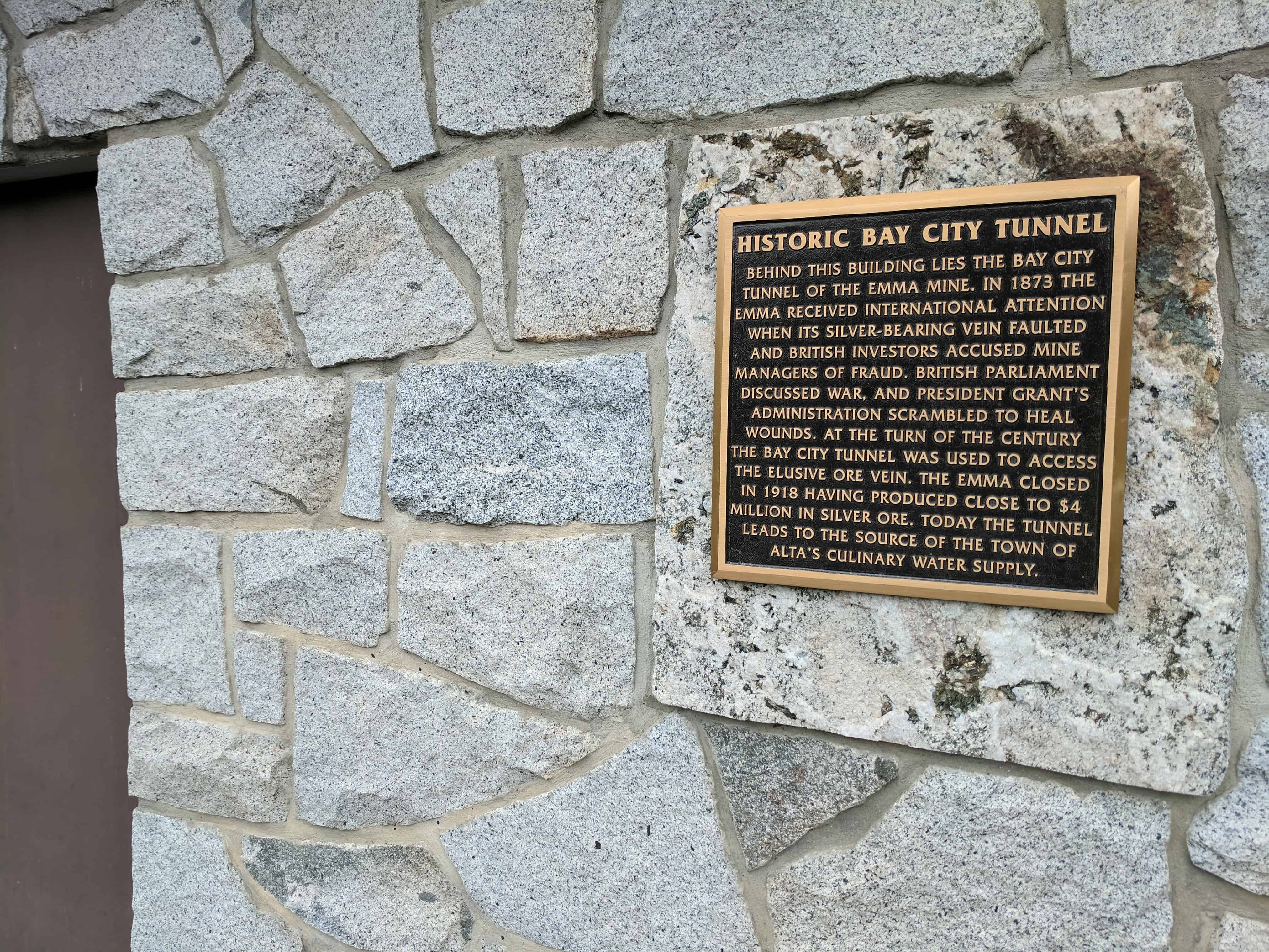
Historic Bay City Tunnel
Behind this building lies the Bay City Tunnel of the Emma Mine. In 1873 the Emma received international attention when its silver-bearing vein faulted and British investors accused mine managers of fraud. British parliament discussed war, and President Grant’s administration scrambled to heal wounds. At the turn of the century the Bay City Tunnel was used to access the elusive ore vein. The Emma closed in 1918 having produced close to $4 million in silver ore. Today the tunnel leads to the source of the town of Alta’s culinary water supply.
Related posts:

25 Thursday Aug 2016
Posted in Uncategorized
Tags
Diamond Fork, Diamond Fork Canyon, Mines, Mining, spanish fork, spanish fork canyon, utah, utah county

A couple cool mines I was checking out in Diamond Fork Canyon, they are across the canyon from each other, the one on the south side of the canyon is across the river from the road and the other is above the road – both are easy to miss if you aren’t watching.


30 Monday Jun 2014
Posted in Uncategorized
Tags
historic, Mines, Payson, Salem, utah, utah county, Woodland Hills


Jay M. Haymond
Utah History Encyclopedia
The so-called Dream Mine is located east of Salem in Utah County. The mine founder, John H. Koyle, was born August 14, 1864 at Spanish Fork, Utah County. He married Emily Arvilla Holt 9 December 1884. They had four son and three daughters. At about age twenty-two, Koyle experienced a dream about lost livestock and other domestic matters. Gradually he became known as a visionary man. He grew to dream about a wide variety of subjects, including world affairs. Many of his predictions came true and earned him a following of faithful admirers.
His membership in the Mormon Church led him to serve a mission in 1888 to 1891 in the Southern States Mission. His dreams continued and he was known as a missionary with prophetic abilities. Following his missionary service, Koyle returned home to his wife and family to resume farming.
In August 1894 he experienced a dream in which he was visited by a figure from another world. The visitor carried him to a high mountain east of Koyle’s house and into the mountain, showing him the various strata and explaining the meaning of the minerals. The visitor showed Koyle an ancient “Nephite” mine with large rooms of mined-out ore bodies. The rooms contained treasure and artifacts of an extinct civilization. Koyle was instructed that he was to open a mine and extract gold for the welfare of “his” people. Specific instructions were given for the mine development leading to rich ore bodies. The riches would be found and released to him and his followers during a time of world crisis. The wealth would be spread to others through Koyle and the people organized around the mine. In this way the name “Relief Mine” was attached to the project. The heavenly messenger made it known that the wealth would not be available for “self gratification.” The dream was repeated for a total of three times. Koyle talked of his dream to friends and others for support. In 1909 the Koyle Mining Company was formed with 114,000 shares of stock issued at $1.00 per share.
Koyle’s dreams continued. He predicted the First World War and the economic crash of October, 1929. He foresaw “horseless carriages” bigger than railroad cars going down the road at great speeds. He especially received instruction on how to develop the mine. Plans included air shafts, escape ways and drainage tunnels. Instructions came to build a processing mill and storage bins for grain. By 1910, Koyle was appointed bishop of the Leland Ward in Spanish fork. The mining activities closely coupled with his church work attracted attention from the Mormon Church leaders. Apostle James E. Talmage, a geologist by training, came to look at the Dream Mine claims and could find no evidence that precious metals would ever be found in the strata being explored. The Mormon Church spoke out against the Koyle mine and associated activities and released John H. Koyle from the bishopric. However, Koyle’s ongoing success as a seer and visionary continued to attract supporters and money, including some members of the Mormon Church leadership. Koyle was getting a mixed message from the Church. For a time, Koyle moved some members of his family to Idaho to pursue farming and while there Koyle was appointed to another bishopric as a councilor, but released when the Mormon leadership learned of the appointment. He continued to attract opposition from the Church for the rest of his life. He negotiated a repudiation of his claims, in 1947 and then reversed himself almost immediately and was excommunicated from the Church 18 April 1948. John H. Koyle died 17 May 1949 in Payson.
The mine continued in fits and starts under the leadership of Quayle Dixon for another twenty-three years. In 1961, a new company, The Relief Mine Company, succeeded the Koyle Mining Company and continued to do the minimum $100 per claim annual assessment work. Little more can be said about the often promised Koyle Dream Mine.
See: Norman C. Pierce, The Dream Mine Story, Salt Lake City, 1972.
12 Tuesday Nov 2013
Posted in Uncategorized
Tags

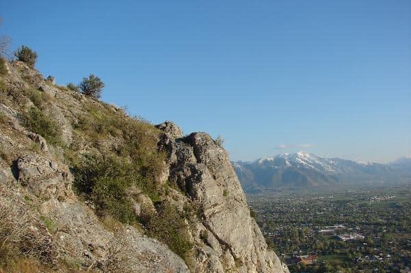
I love Little Rock Canyon, it is located at the north end of Springville, Utah. The canyon is covered with slick rockslides and gorgeous cliffs, there are a few caves and mines as well.
One cave, far up on the North side has many names, Springville Cave, Another Springville Cave Link, C Cave, Rock Cave, Gold Bar Cave, and is the place where in the 1980′s two boys found a gold bar.
If you want to hike up the canyon there is a trail that goes up the South side, if you’re looking for the caves/mines go up the bottom of the canyon and towards the North side.


On May 5th, 2013 we hiked up to “Rabbit Ears” to celebrate my birthday, I hadn’t been there in a long time.
Here’s a picture of Brady entering, and another of the “ears.”


Visit my list of places in Utah.
EDIT:
Here are pictures I took in 2007 I just dug up, the canyon, the cache I hid there and the “rabbit ears.”


Here’s a few other pictures I took farther up the canyon, a large rockslide I climbed up and explored.


