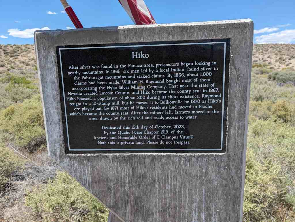
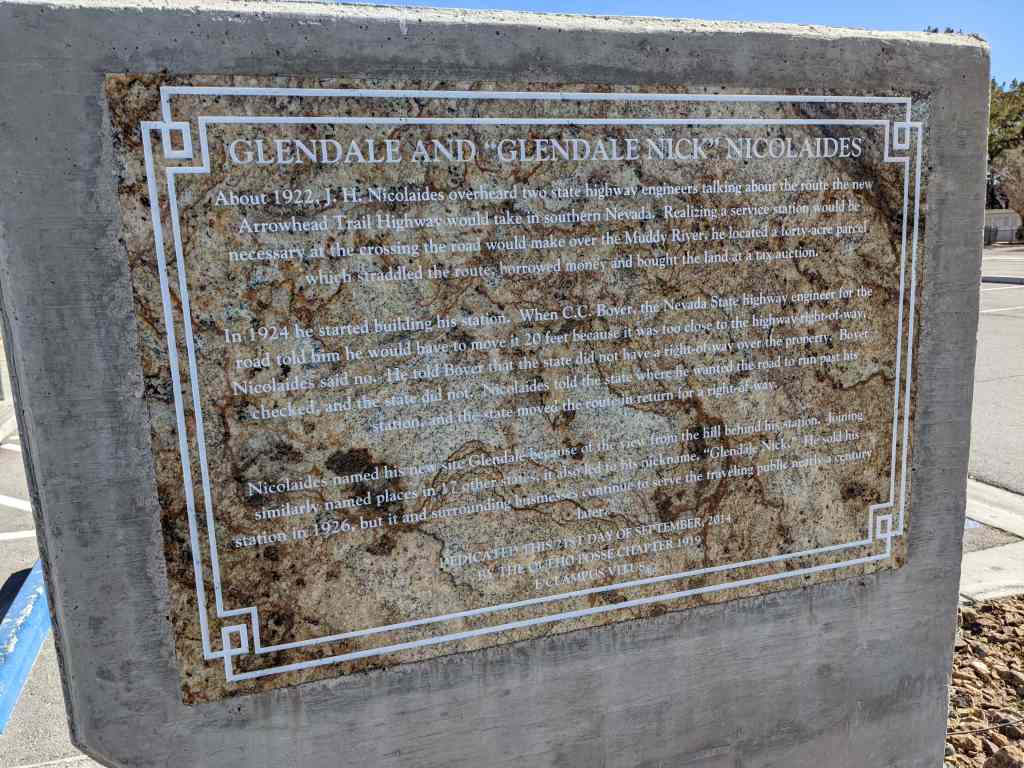
• About JacobBarlow.com
  • Cemeteries in Utah
  • D.U.P. Markers
  • Doors
  • Exploring Utah Email List
  • Geocaching
  • Historic Marker Map
  • Links
  • Movie/TV Show Filming Locations
  • Oldest in Utah
  • Other Travels
  • Photos Then and Now
  • S.U.P. Markers
  • U.P.T.L.A. Markers
  • Utah Cities and Places.
  • Utah Homes for Sale
  • Utah Treasure Hunt

JacobBarlow.com

~ Exploring with Jacob Barlow

JacobBarlow.com

Tag Archives: E Clampus Vitus

Hiko

26 Monday Aug 2024

Posted by Jacob Barlow in Uncategorized

≈ Leave a comment

Tags

E Clampus Vitus, Historic Markers, Nevada

Hiko

After silver was found in the Panaca area, prospectors began looking in nearby mountains. In 1865, six men led by a local Indian, found silver in the Pahranagat mountains and staked claims. By 1866, about 1,000 claims had been made. William H. Raymond bought most of them, incorporating the Hyko Silver Mining Company. That year the state of Nevada created Lincoln County, and Hiko became the county seat in 1867. Hiko boasted a population of about 300 during its short existence. Raymond rought in a 10-stamp mill, but he moved it to Bullionville by 1870 as Hiko’s ore played out. By 1871 most of Hiko’s residents had moved to Pioche, which became the county seat. After the miners left, farmers moved to the area, drawn by the rich soil and ready access to water.

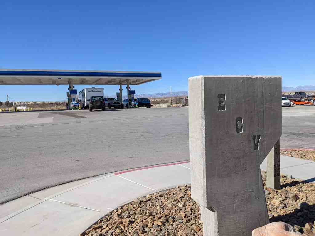
Dedicated this 15th day of October, 2023, by the Queho Posse Chapter 1919, of the Ancient and Honorable Order of E Clampus Vitus®. Note this is private land. Please do not trespass.

Related:

  • Other E Clampus Vitus Markers
  • State Historic Marker also located here.

Glendale and “Glendale Nick” Nicolaides

27 Monday Nov 2023

Posted by Jacob Barlow in Uncategorized

≈ Leave a comment

Tags

E Clampus Vitus, Glendale, Historic Markers, Nevada

Glendale and “Glendale Nick” Nicolaides

About 1922, J. H. Nicolaides overheard two state highway engineers talking about the new route Arrowhead Trail Highway would take in southern Nevada. Realizing a service station would be necessary at the crossing the road would make over the Muddy River, he located a forty-acre parcel which straddled the route, borrowed money and bought the land at a tax auction.

In 1924 he started building his station. When C. C. Boyer, the Nevada State highway engineer for the road told him he would have to move it 20 feet because it was too close to the highway right-of-way, Nicolaides said no. He told Boyer that the state did not have a right-of-way over the property. Boyer checked, and the state did not. Nicolaides told the state where he wanted the road to run past his station, and the state moved the route in return for a right-of-way.

Nicolaides named his new site Glendale because of the view from the hill behind his station. Joining similarly named places in 17 other states, it also led to his nickname, “Glendale Nick.” He sold his station in 1926, but it and the surrounding business continue to serve the traveling public nearly a century later.

Dedicated this 21st Day of September, 2014 by the Queho Posse Chapter 1919 E Clampus Vitus

Located at 2300 Glendale Boulevard in Glendale, Nevada

  • E Clampus Vitus Historic Markers

Carbon Fuel Company #2 Mine

15 Friday Sep 2023

Posted by Jacob Barlow in Uncategorized

≈ 3 Comments

Tags

E Clampus Vitus

Carbon Fuel Company #2 Mine

The mine was opened in 1916 by George Diamanti as Hardscrabble Coal Company which was operated by Utah Fuel. By 1963 after numerous name and ownership changes, the mine was owned and operated as Carbon Fuel Company.

On December 16, 1963 at 11:50 am a violent explosion occurred which took the lives of 9 miners. One miner Jesus Nunez Price, who was 2400 feet from the explosion was thrown 200 feet, but walked to the mine entrance and was taken to Carbon Hospital in Price. He survived but 9 other miners died.

The Miners that died in the explosion were:

  • Mike Ardohain
  • Victor Fossat
  • Andy Juvan
  • Archie Larsen
  • Heino Linn aka Henio Liin
  • Benino Montoya
  • Gerald Nielsen
  • John Senechal Jr.
  • Benjamin Valdez

This historic marker is located on the Price Riverwalk trail in Helper, Utah and was dedicated by the Matt Warner Chapter 1900 of E Clampus Vitus on July 14, 2012 (6017)

N 39.69380 W 110.86191

  • E Clampus Vitus Markers

Rolapp / Royal

14 Thursday Sep 2023

Posted by Jacob Barlow in Uncategorized

≈ Leave a comment

Tags

E Clampus Vitus

Rolapp / Royal

The area around the rock formation known as Castle Gate was originally settled as Bear Canyon.

In 1913 Frank Cameron opened a small mine operation and the town was renamed Cameron.

In 1917 Cameron sold the mine to Henery Rolapp and the town was renamed Rolapp. As the town grew it spread across the canyon floor and up Price Canyon.

In the 1920’s the mine was purchased by the Royal Coal Company and the name changed for the final time to Royal.

In 1930 the mine was sold to the Spring Canyon Coal Company, but the town remained known as Royal. At this time Royal had a school, hospital, general store, post office, and a small service station. The highway through Price Canyon was new in 1930 and it became the towns main street.

Four miners died between 1914 and 1916 when the town was known as Cameron. Between 1923 and 1957 while the town was called Rolapp / Royal the mine took the lives of 33 miners.

As happened with other coal camps in Carbon County, by the late 1950’s Royal was just another ghost town.

This historic marker is located on the Price Riverwalk trail in Helper, Utah and was dedicated by the Matt Warner Chapter 1900 of E Clampus Vitus on September 7, 2013 (6018)

N 39.69380 W 110.86191

  • E Clampus Vitus Markers

Pioche’s Boot Hill

24 Monday Apr 2023

Posted by Jacob Barlow in Uncategorized

≈ Leave a comment

Tags

E Clampus Vitus, Historic Markers, Nevada, Pioche

Pioche’s Boot Hill

A mining town from the late 1860s, Pioche is one of the most intact historic communities in Southern Nevada. Named for Francois L.A. Pioche, a San Francisco financier who, with partners, acquired some of the earliest claims in the area, the town grew quickly. Its isolation led to a lawlessness which was as famous as its mines.

The many murders in the area led to the creation of Boot Hill, the earliest cemetery in Pioche. There were six deaths from lead poisoning in the town before the first person died of natural causes, and this cemetery was in active use during the boom years. Though religious and fraternal cemeteries were later created, Boot Hill continued to be used for many years. Though in use today, Boot Hill remains a part of the history of Pioche. Let us not forget those who are buried here, for they too are a part of our heritage.

Dedicated this 9th day of May, 2009
by the Queho Posse Chapter 1919
E Clampus Vitus
in cooperation with the Pioche Chamber of Commerce

  • E Clampus Vitus Historic Markers
  • Boot Hill Cemetery

The Railroads of Pioche

28 Tuesday Feb 2023

Posted by Jacob Barlow in Uncategorized

≈ Leave a comment

Tags

E Clampus Vitus, Historic Markers, Nevada, Pioche

The Railroads of Pioche

Railroads were the best option for moving ore in the nineteenth and twentieth centuries. For the mines of Pioche, four railroads eventually served the area.

The first was started in 1872. Originally called the Pioche and Bullionville, it was reincorporated as the Central Nevada Railroad in 1873, and renamed the Nevada Central, though not related to the railroad near Ely. It went out of business in 1880.

In 1889, the Pioche Pacific Transportation Company, known as the Jackrabbit Line, built a new narrow-gauge line. The Pioche Pacific connected with the Jackrabbit Mine to the east. It did not finally close until 1948.

Next was the Caliente & Pioche Railroad. It was built by San Pedro, Los Angeles, and Salt Lake Railroad starting in 1907, and connected Pioche to the outside world. It became part of the Union Pacific.

The final Pioche railroad was the Price Consolidated Railroad which began constructed in 1912. It too became part of the Union Pacific in 1940.

This plaque (located at Pioche Town Park at 186 4th Street in Pioche, Nevada) was placed by the Queho Posse, #1919 of the ancient and honorable order of E Clampus Vitus, with the Town of Pioche and the Pioche Chamber of Commerce.

Harrisburg

02 Thursday Feb 2023

Posted by Jacob Barlow in Uncategorized

≈ Leave a comment

Tags

E Clampus Vitus, Harrisburg, Historic Markers, Washington County

Harrisburg

In 1859, after helping settle San Bernardino California, Moses Harris moved his family to Utah and settled on the Virgin River near Quail Creek. In 1862 a flood forced the settlers further up Quail Creek to the Cottonwood Creek fork. Due to the many large rocks in the area the settlers built their homes and barns of stone. Rocks gathered while clearing their land for planting were used to establish property lines, leaving several miles of stone fences. By 1864 there were sixteen families totaling 128 people living here. In 1868 the population was about 200 people. Many worked at the Silver Reef mines and mills. By 1892 repeated flooding had driven away all but six families.

This historic marker is located in Harrisburg, Utah and was dedicated by the Matt Warner Chapter 1900 of E Clampus Vitus on March 21, 1999 (6004)

Curved Trestle Bridge

26 Monday Dec 2022

Posted by Jacob Barlow in Uncategorized

≈ Leave a comment

Tags

Carbon County, E Clampus Vitus, Helper, Historic Markers, utah

Curved Trestle Bridge

Utah Railway was created in 1912 to provide improved service to the coal mines of western Carbon and Emery counties. Tracks from Hiawatha to the Utah Railway junction near Martin were completed in Oct. 1914. A steel girder bridge 135 ft. high, 634 ft. long and on a 60 percent curve was constructed in order to span Gordon Creek. This remains the longest steel girder bridge of its height in the state of Utah. Original trains were 50 ton capacity cars pulled by steam locomotives. But this same bridge supports todays 100 ton capacity steel cars and 105 ton capacity aluminum cars pulled by modern diesel locomotives. Utah Railway began as a single commodity railroad and remains so today.

This historic marker is located at the Helper Museum at 294 South Main Street in Helper, Utah and was dedicated by the Matt Warner Chapter 1900 of E Clampus Vitus on July 11, 1998.

  • E Clampus Vitus Markers

Matt Warner

26 Monday Dec 2022

Posted by Jacob Barlow in Uncategorized

≈ 1 Comment

Tags

Carbon County, E Clampus Vitus, Helper, Historic Markers, utah

Matt Warner
April 12, 1864-December 21, 1935

The Bandit Who Became Judge

Matt Warner was born Willard E. Christiansen in Ephraim, Utah. He left home at the age of 14 after a fight in which he thought he killed the town bully. He took the name Matt Warner, became a cattle rustler, bank robber and rode with Butch Cassidy until going to prison on trumped up charges in 1897. He was released in 1900, with a full pardon from Governor Wells. In the following years, he became one of the best deputy sheriffs, city police officers, and justices of the peace Carbon County has ever known. As a man of the law, Warner won the love of all Carbon County, except the lawyers, and stuffed shirts. He was strictly a man of the people.

This historic marker is located on the Carbon Hotel at 262 South Main Street in Helper, Utah and was dedicated by the Utah Outpost Mountain Charlie Chapter 1850 of E Clampus Vitus on July 25, 1981.

  • E Clampus Vitus Markers

The Nine Mile Road

30 Wednesday Nov 2022

Posted by Jacob Barlow in Uncategorized

≈ 1 Comment

Tags

Carbon County, E Clampus Vitus, Historic Markers, Price, utah

The Nine Mile Road

The road through Nine Mile Canyon was constructed in 1886 by the Buffalo Soldiers of the U.S. 9th Cavalry to connect Fort Duchesne to the railroad in Carbon County. Most of the stagecoaches, mail and freight passed through Nine Mile into the Uintah Basin, which lead to the development of the canyon and the small town of Harper, presently known as Preston Nutter Ranch. Harper’s population peaked by 1910. The arrival of the Uinta railroad rerouted traffic away from the canyon and Harper became a ghost town by the early 1920’s.

This historic marker is located at the 600 South Trailhead of the Price River Trail, approximately 600 South Carbon Avenue in Price, Utah and was dedicated by the Matt Warner Chapter 1900 of E Clampus Vitus on July 9th, 2011 (6016)

  • E Clampus Vitus Markers
← Older posts

Follow Jacob

Follow Jacob

Blog Stats

  • 2,030,859 hits

Social and Other Links

BarlowLinks.com

Recent Posts

  • Eyes Westward
  • Wellsville Relief Society Meetinghouse
  • Angels Are Near Us
  • Hiram Clawson Silver
  • Bingham Fort

Archives


Loading Comments...