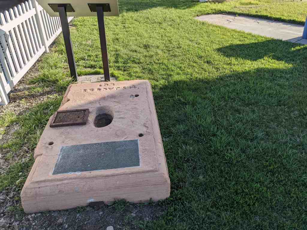
This stone was base for the first generation at the Great Basin Smelting and Concentrating Works.
Managed by General P. E. Connor at Stockton, Utah Territory
Presented by Rush Valley Camp, DUP, Oct. 1983 Courtesy, Elva B Russell and son Kevin Russell.
This is located in a little roadside park at the corner of Connor Avenue and Silver Avenue in Stockton, Utah along with other historic markers. Those located here are:
The Black Rock Site includes some of the ruins of the Black Rock Resort and it was added to the National Historic Register (#100006332) on March 24, 2021.
1910s view of Black Rock surrounded by the waters of Great Salt Lake. (Utah State Historical Society)
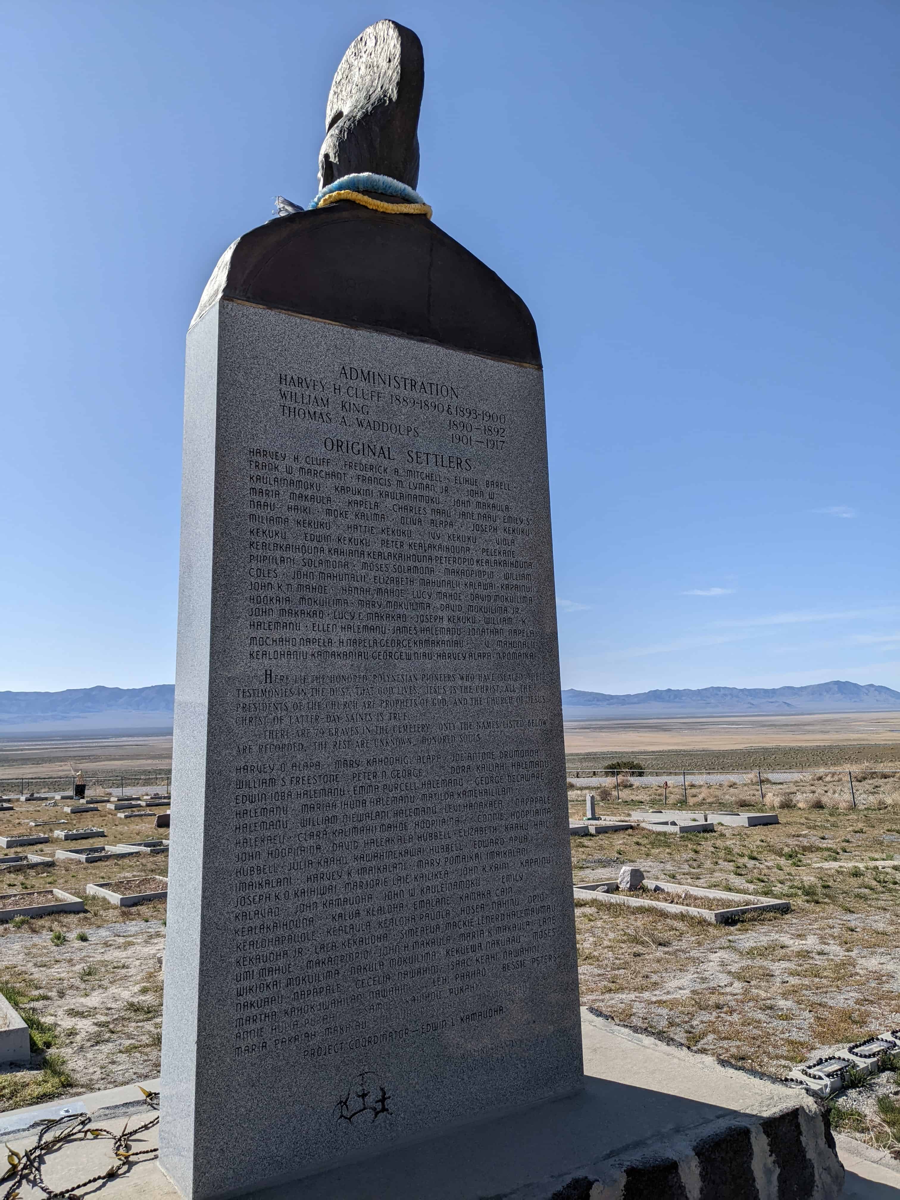
This hallowed place was dedicated on August 28, 1890 by President Wilford Woodruff for all the nations in the isles of the seas, the Polynesian pioneers, their descendants and the faithful Church leaders who left their home in the mid 1800’s and migrated to this gathering place in Zion to be married in the holy Temple for time and eternity.
For 28 years (1889–1917) Iosepa was their home. In spite of the climate, isolation, loneliness, sickness, hardship and death, their faith and courage never faltered. They overcame the cold winter, the summer heat, enjoyed the new life of spring and the bounteous harvest of the fall.
Their native songs and dances filled this beautiful valley, which they made “bloom as a rose,” with love and aloha. A few remained in Utah, some on this consecrated spot, while the rest returned home to their beloved isles of the sea.
The seeds of our Polynesian pioneers bore fruit in Hawaii—the Laie Temple, Brigham Young University – Hawaii, and the Polynesian Cultural Center. Holy Temples stand firm in New Zealand, Western Samoa, Tonga, and Tahiti as monuments to the testimonies of the faithful Polynesian pioneers. We close this memory with their song of love: Iosepa Kuu Home Aloha Iosepa My Home of Love / Iosepa Kuahiwi Ika Nani Iosepa With its Beautiful Mountains / Iosepa Ka Home No Ka’oi Iosepa My Best Home.
This lonely fire hydrant serves as a land marker for the town site of Iosepa, Utah, located on the desert floor between Cedar Mountain and the Stansbury Range in Skull Valley. Iosepa was named after Joseph F. Smith, 6th president of the L.D.S. Church. About 50 Hawaiians left Salt Lake City via Garfield by train, then by 20 wagons to Grantsville, spent the night arriving in Iosepa August 28, 1889.
The public square consisted of 169 acres, with four center streets 132 ft. wide. On four sides of the town park a row of trees were planted in the center of each street. All the other streets were 66 ft. wide and the blocks were divided into 4 lots each containing ¾ acres. All the streets had Hawaiian names. The original purchase consisted of 1,920 acres, of which 200 were under cultivation, the next two years accumulated to 5,273 acres. The water came from five streams, collected in an open ditch, put into a concrete conduit that furnished culinary water to each home. A fire hydrant and irrigation ditch went with each lot. The cemetery, about ½ acre is located a mile northeast of the settlement. Iosepa won the State prize in 1911 for the best kept town and the most progressive city in the State of Utah. Only the Hoopiiana family and J. Palikapeg Nawahine remained in Utah, the rest returned home to Hawaii to settle and help built the Laie Temple (1917–1919). Iosepa returned to dust, leaving a heritage of the faithful Polynesian Pioneers and closed the chapter in the great western American History.
The Iosepa Community developed after Polynesian converts to the Mormon faith were employed as laborers by the Iosepa Agriculture and Stock Company in 1889. After numerous hardships, including bouts with leprosy, the colony attained a degree of financial independence and its population reached 228. In 1915 when the L.D.S. Church began to build the Hawaiian Temple, the need for “gathering” subsided. The Iosepa project was allowed to end and most of the settlers and their children returned to the Islands by 1917.
Mormon Church Converts from Polynesia settled in Skull Valley in 1889-1917. Working for the Church-owned Iosepa Agriculture and Stock Company.
Their settlement located 1/2 mile to the southwest and named Iosepa (Joseph) after Joseph F. Smith, then President of the church flourished until 1917 when a Hawaiian Temple was constructed. Most of the Islanders returned to their homeland, many who succumbed to the hardships of the land are buried in this cemetery.
The Iosepa settlement in Skull Valley, Utah, represents both a unique colonization effort by the Mormon Church and in the West itself. Very early in the 1850’s the Mormon Church had sent missionaries to the Polynesian people. Joseph F. Smith served his first mission at the age of fifteen and became especially beloved to them. Later many answered the “call to gather to Zion,” and settled near Wasatch Springs in North Salt Lake City However, as they did not Integrate into the society very well, and rumors of leprosy were reported, the Mormon Church undertook to settle them as a group in Skull Valley. Under a paternalistic arrangement with the Iosepa Agriculture and Stock Company (incorporated August 7, 1889), these people were employed as laborers to do farm and ranch work. In time a community of 228 souls was developed in which the Polynesian culture flourished. Fish were raised in the springs and marshes nearby. The luau was preserved as were many of their dances and customs. The Polynesians were popular performers throughout the area.
After numerous hardships, including bouts with leprosy, the colony obtained a degree of financial independence by 1910. Their standard of living was commensurate with others living in that area. When in 1915, the L.D.S. Church began to build a temple in Hawaii, the need for “gathering” subsided. The Iosepa project was allowed to end. Most of the settlers and their children returned to the Islands by 1917. However, a few remained in the area of Iosepa and Utah. Today descendants visit the region to view “the land of their inheritance.”
The first funeral was held September 15, 1889 and the cemetery established. Many others have been buried there. Finally, in 1968 Tony Hoopiana, who had been born at Iosepa and lived nearby all his life, was buried in a northeast corner plot. This Hawaiian is home, forever.
The Iosepa Settlement Cemetery in Iosepa, Utah was added to the National Historic Register (#71000856) on August 12, 1971.
The area of Iosepa, in Skull Valley, Utah, was a large 1,920 acre ranch originally. With the settlement of the Hawaiians, a small community was established, following the “block grid” common to Mormon villages. A center block was reserved for the church, a schoolhouse and other public buildings, which were built in time. At first the water supply came from a stream and ran down the edges of the streets in ditches. Later a water system was piped through the town. One fire hydrant still remains. Most of the buildings have been removed or destroyed.
However, north of the town site sets the “Iosepa Cemetery,” a small plot enclosed with a black barbed wire fence, where several score of the colonists have been buried. Many of the graves are unmarked, others have only wooden markers, some carved, and a few stone markers reflecting their artistic qualities.
Although poorly cared for today, there is genuine interest in proper fencing and upkeep of the site from both the Bureau of Land Management personnel and the Deseret Livestock Company whose property line crosses the cemetery. Its location will permit the public to visit it, where an interpretive display can be developed.
The cemetery best preserves the story of this distinctive settlement experience by a Polynesian minority.
Captain J. H. Simpson was a U. S. Military officer sent by the government to explore a western railroad route. Simpson’s route was later used for the Pony Express and Overland Stage. He camped at the springs October 23, 1853, and first named them Pleasant Springs because the water was excellent. The springs were later named to honor Captain J. H. Simpson, similar to the nearby Simpson Mountains which Simpson originally named after Captain Stephen Champlin.*
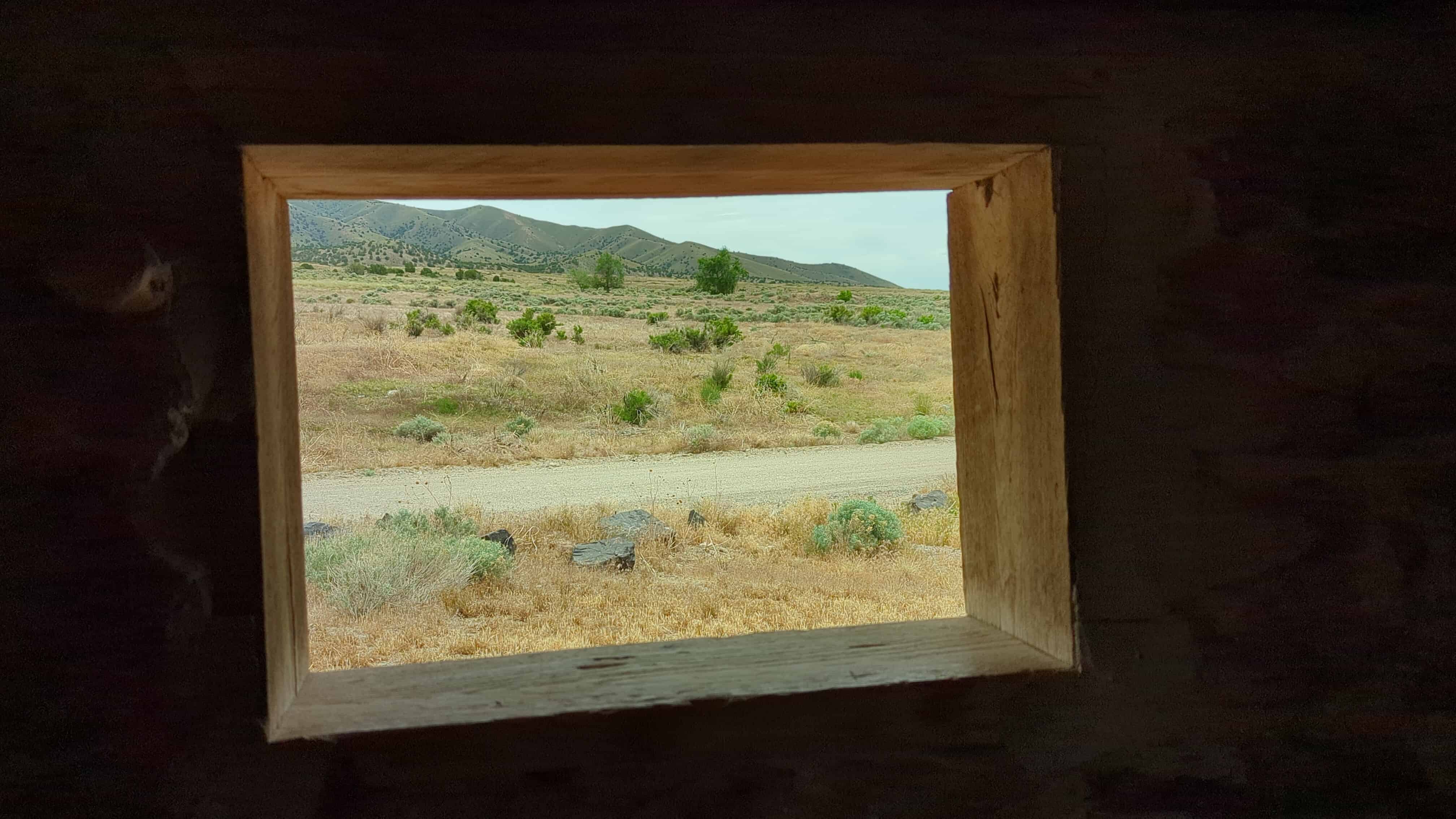
Alvin Anderson used stone from the abandoned Pony Express station when he built this cabin in 1893. It was intended for his wife, who died in childbirth before she could live in it.
Risky Business
In 1855, U.S. Senator William Gwin of California urged Congress to fund a faster, overland express mail system. Gwin had envisioned a system of horses and riders which, supported by periodic livery and supply stations, could bridge the gap between California and Missouri. Congress turned Gwin down.
The dream of a 10-day express relay system from Missouri to California was ultimately established by a private enterprise – the dominant military freight contractor of the American West – the partnership known as Russell, Majors & Waddell.
In hopes of winning a new government mail contract, RM&W quickly organized the Central Overland California & Pikes Peak Express Company – the Pony Express. Organizing the company and setting it in motion necessitated the hiring of about 80 riders and 200 station keepers, contracting for the use of existing stage and mail relay stations, building new relay stations where needed, and purchasing supplies, equipment, and 500 fast running horses.
Meanwhile, technology was outpacing the ponies as other private companies were hastily building a telegraph line between Omaha and Sacramento. With the connection of the transcontinental telegraph wires in Salt Lake City on October 24, 1861, a new, less expensive, and faster communication system ended the need for the Pony Express – nearly 19 months after the first rider’s departure from St. Joseph, Missouri, on April 3, 1860.
Today, even the telegraph wires have been largely forgotten. However, the memory of solitary Pony Express riders – valiantly galloping across the prairie, through the sagebrush and mountain passes of these wild and open lands – still inspires people around the world.
Why Take the Risk
Following the end of Mexican Government control in 1848, California was admitted to the United States in September of 1850. A few months before the cessation, gold was discovered at Sutter’s Mill.
As the gold fever spread, in addition to pioneers seeking opportunities to begin a new life, tens of thousands of gold seekers, miners, and entrepreneurs began pouring into the new state.
The rapidly increasing population demanded swifter communication with the east, which prompted the United States Government to keep the new state aware of its political activities and updates about the Civil War before the news became stale.
Winning a government contract for shipping mail to and from California could potentially be very profitable, especially if it could be done more efficiently and competently than anybody else could.
The Crowds Cheered On…
In 1845, it took six months to get a message from the east coast of the United States to California. By the time it arrived, the news was old. In the late 1850s, a half million people had migrated west, and they wanted up-to-date news from home. Something had to be done to deliver mail faster and to improve communication in the expanding nation.
“The Central Overland California and Pikes Peak Express Company,” a subsidiary of Russell, Majors, and Waddell, announced the formation of the Pony Express on January 27, 1860. They planned to carry letter mail between St. Joseph, Missouri and Sacramento, California in only ten days. Although the Pony Express was a financially risky enterprise, the company hoped to attract a lucrative contract with the U.S. Postal Service.
Knowing that a healthy horse could run at a full gallop for only 10 to 12 miles, the Pony Express needed stations for its riders to change mounts. They utilized existing stage stations on the eastern end of the route, but needed to build many new station in remote areas across the Great Basin. Alexander Majors said that 400 to 500 mustang horses were purchased, 200 men were hired to manage the station, and 80 riders signed on to begin the run of the Pony Express.
Although the Pony Express captured the admiration, imagination, and hearts of people, it was a financial disaster for its founders. The Pony era, however, was not brought to an end by its financial failure, weather, or even problems with Indians – but by the completion of the Transcontinental Telegraph on October 26, 1861.
“Every neck is stretched, and every eye stained… Across the endless prairie a black spec appears… In a second or two it becomes a horse and rider, rising and falling, rising and falling – sweeping toward us – growing more and more distinct, and the flutter of hoofs comes faintly to the ear – another instant a whoop and a hurrah from our upper deck, a wave of the rider’s hand, but no reply, and man and horse burst past our excited faces, and go winging away like belated fragment of a storm.” – Mark Twain – Roughing It, 1872.
Strength and Endurance
Descriptions of the variety and number of horses used by the Pony Express became distorted during the course of its history since November 1861. In general, the type of horse used for carrying the rider and mail depended greatly on the region. The more fleet-footed thoroughbred horses worked fine on the central prairies, but the strength and endurance of half-broken mustangs were needed to cross the arid deserts and rugged mountain ranges of the West. Alexander Majors, one of the three founders of the Central Overland California and Pike’s Peak Express Company’s Pony Express, chose the California mustang for its strength and endurance, describing it “as alert and energetic as their riders.”
As each of the more than 100 stations spread along the route, relays of horses needed to be kept in sufficient numbers to meet the demands of the relay system. As the C.O.C.&P.P.E.C prepared for the “start-up” of the Pony Express, the company estimated that it would take approximately 75 horses to make the nearly 2,000 mile trip from Missouri to California.
A little more than two months before the first riders left from St. Joseph and Sacramento, the firm of Russell, Majors, and Waddell began purchasing 500 of the best horses available, paying as much as $200 a head for some stock. One ad, posted in the Kansas Leavenworth Daily Times, asked for “200 grey mares, from four to seven years old, not to exceed fifteen hands high, well broke to the saddle and warranted sound …”
So, just how far and how long can a horse run? A modern-day horse in good shape can travel at a full gallop on flat terrain for maybe five to eight miles. Over the mountainous terrain in the Sierra Nevada, a horse and rider may be able to cover five miles. Pony Express mustangs could travel at speeds of about 10 miles an hour, but at times could gallop at speeds up to 25 miles per hour. At a full gallop, the distance that the horse could travel before becoming exhausted depended on several variables—if it was a hot or cool day, state of health, and when the horse last had a drink of water.
A good Pony Express rider rode his horse at a steady spring and generally galloped the horse only to get out of harm’s way. None were easy to ride, but all agreed that in a race for life and mounted on a half-broken mustang, the express rider could leave danger far behind.
There were about eighty pony riders in the saddle all the time, night and day, stretching in a long, scattering procession from Missouri to California, forty flying eastward, and forty toward the west, and among them making four hundred gallant horses earn a stirring livelihood and see a deal of scenery every single day of the year.”—Mark Twin, Roughing It, 1872
“The worst imps of Satan in the business. The only way I could master them was to throw them and get a rope around each foot and stake them out, and have a man on the head and another on the body while I trimmed the feet and nailed the shoes on … It generally took half a day to shoe one of them.” —Pony Express Farrier and Station Keeper, Levi Hansel, in 1901 describing his experience shoeing half-wild California mustangs at Seneca, Kansas. Photograph—D.B. Young, wild mustangs near Simpson Springs Pony Express Station, January 2010.
Patsy Vario Jr. June 25, 1924 – Dec. 19, 1944 Died in Milne Bay, New Guinea Served in the South-East Asian Theatre WW II U. S. ARMY Pat Vario & Don Haslem were high school buddies when war broke out. Both joined the U.S. Army to serve their nation on the “Buddy Team Enlistment Program” Both enjoyed life giving the ultimate sacrifice and died side by side together. Our thanks to Bob Walraven who also served with Pat and Don. Patsy had three brothers who served in WW II Anthony, Frank & Ernest