• About JacobBarlow.com
  • Cemeteries in Utah
  • D.U.P. Markers
  • Doors
  • Exploring Utah Email List
  • Geocaching
  • Historic Marker Map
  • Links
  • Movie/TV Show Filming Locations
  • Oldest in Utah
  • Other Travels
  • Photos Then and Now
  • S.U.P. Markers
  • U.P.T.L.A. Markers
  • Utah Cities and Places.
  • Utah Homes for Sale
  • Utah Treasure Hunt

JacobBarlow.com

~ Exploring with Jacob Barlow

JacobBarlow.com

Tag Archives: Union Fort

Union Fort

10 Tuesday Mar 2020

Posted by Jacob Barlow in Uncategorized

≈ Leave a comment

Tags

DUP, Forts, Historic Markers, Union Fort

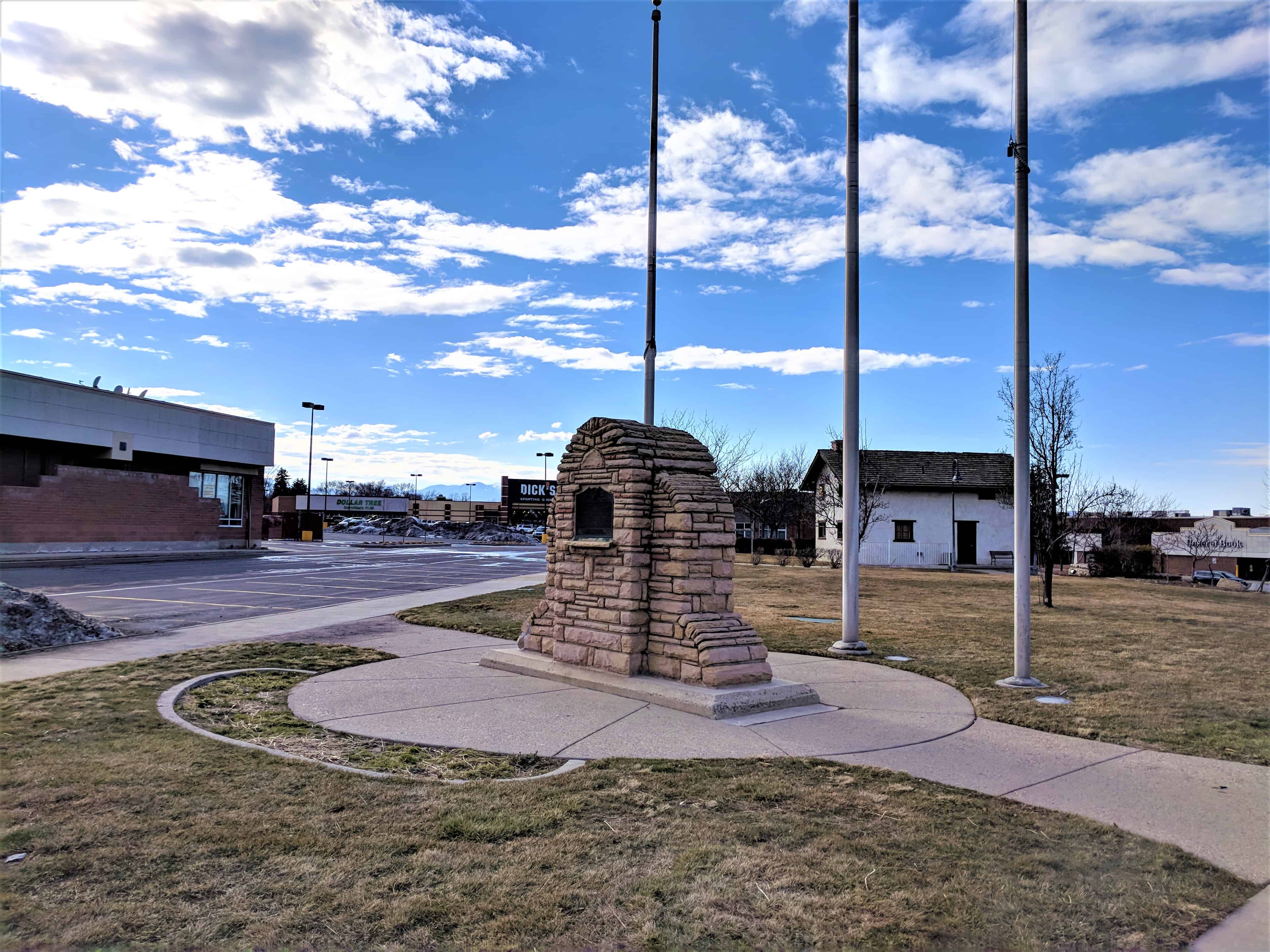
Beginning in late 1853, Union Fort was erected as protection for pioneers who had been homesteading along Little Cottonwood Creek since April 1849. Skirmishes erupted from Sanpete to Salt Lake Counties between warriors of Timpanogos Ute Chief Walkara and settlers. Walkara had become upset by Mormon efforts to stifle Indian slave trading and the increased intrusion of settlers into traditional Indian hunting grounds.

Brigham Young, president of The Church of Jesus Christ of Latter-day Saints and Utah territorial governor, ordered every community to “fort up” and the people to move into the enclosures as quickly as possible for protection.

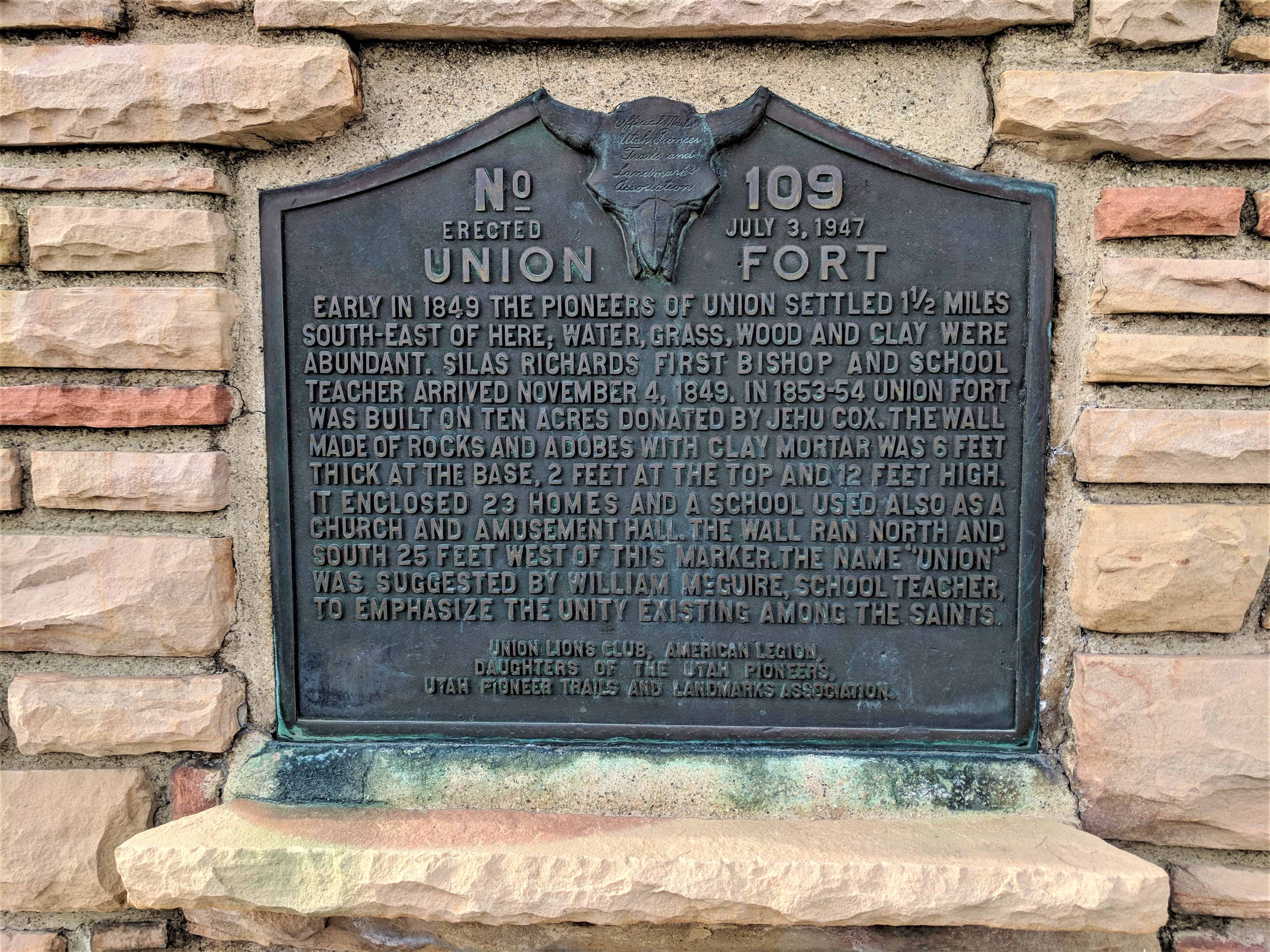
Jehu Cox, one of the first settlers, was appointed to a committee to select the fort site. Cox offered to donate ten acres of land surrounding his 1849 two-story adobe home. His offer was accepted and construction began immediately.

Each family was assigned a section of the wall to build. Foundations were dug 4 feet deep and filled with rock and clay. The 12-foot-high walls were constructed of rock and adobe and were 6 feet thick at the bottom, tapering on the inside to 2 feet thick at the top. The outside walls were vertical. Gun portholes were placed in the walls every few yards, and bastions were built on the northwest and southwest corners. Only three walls were completed by late 1854 because the north side of the fort was protected by a large irrigation canal and steep embankment that provided adequate protection.

The fort had two, 33-foot-wide roads dividing the interior into three east-west rectangular blocks which were further subdivided into 24 building lots each. The roads ended at huge gates that were kept locked at night. Another 15-foot-wide road was laid out along the inside of the fort walls for movement of military supplies and men. A gravel path, running north and south, gave the citizens a walkway through the middle of the fort.

Twenty-three log and adobe homes were finished by 1854. Some built new two-story adobe dwellings while others living along the creek tore down their log cabins or small adobe brick houses and reassembled them inside the fort. Each family was also allocated a lot outside the fort to corral their livestock. Armed men stood guard as the farming continued in nearby fields.

Other structures were built within the fort. A two-story schoolhouse, 20 feet by 36 feet, was constructed in the middle section and also served as a church and community center. Wooden pegs were used instead of expensive nails. James McMinds was the first teacher.

A community granary was built southwest of the school and was never locked. It was constructed so a team and wagon could be driven through, and it allowed each family access to their ground-floor grain storage and produce stored in the loft. A boarding house was provided for teamsters who hauled daily loads of ore and granite out of Little Cottonwood Canyon for the Salt Lake Temple.

Military-trained citizens provided defense for Union Fort. Every male between the ages of 18 and 45 belonged to the territorial militia. They drilled and practiced often and rotated standing guard.

The Union Fort settlers had immigrated from different countries, spoke many languages, and followed their traditional customs. Often they could not understand each other, but they all labored together in united effort for their common good. As a result, the name of the settlement was changed from Little Cottonwood to Union.

Union Fort was never attacked. Brigham Young signed a peace treaty with Chief Walkara in 1854, and Indian difficulties ceased late in the 1850s. The settlers began moving back into their homesteads. The fort walls were gradually dismantled and the land used for farms and gardens. The fort served the pioneer settlers well and provided sanctuary and security, uniting them during insecure times.

Related Posts:

  • U.P.T.L.A. Historic Marker “Union Fort“

Union, Utah

02 Friday Dec 2016

Posted by Jacob Barlow in Uncategorized

≈ 2 Comments

Tags

Cottonwood Heights, Fort Union, Midvale, Salt Lake County, Sandy, Union, Union Fort, utah

2016-11-10-17-10-20

In 1849, eight families were sent to settle what would become Union. According to A Union, Utah, History by Steven K. Madsen, “Jehu Cox, the first settler of Union, donated ten acres of his farming land for the establishment of [a] fort.” “By 1854, a total of 23 homes had been built inside the fort – the population stood at 273,” Madsen continued. The population according to the U.S. Census Bureau was 484 in 1880, 602 in 1890, and 757 in 1900. Between 1848 and 1872, other settlements included Butler Bench, Poverty Flats, and Danish Town.

What was once Union is now parts of Cottonwood Heights, Midvale, and Sandy. Within the Cottonwood Heights area, Butler and Union Precincts (a basic form of county government) were established in 1877, as were Butler School District 57 and Union School District 23. The Unified Jordan School District would not be created until 1905.

Union Fort

23 Tuesday Dec 2014

Posted by Jacob Barlow in Uncategorized

≈ Leave a comment

Tags

Fort Union, Forts, historic, Salt Lake City, Salt Lake County, SUP, Union Fort, utah

  • 2018-03-11 16.58.17

Union Fort
Early in 1849, the pioneers of Union settled 1 1/2 miles south-east of here; water, grass, wood and clay were abundant. Silas Richards first Bishop and school teacher arrived November 4, 1849. In 1853-54 Union Fort was built on ten acres donated by Jehu Cox. The wall made of rocks and adobes with clay mortar was 6 feet thick at the base, 2 feet at the top and 12 feet high. It enclosed 23 homes and a school used also as a church and amusement hall. The wall ran north and south 25 feet west of this marker. The name “Union” was suggested by William McGuire, school teacher to emphasize the unity existing among the Saints.

Located in Midvale, Utah.

See other historic markers in the series on this page for UPTLA/SUP Markers.

  • 2018-03-11 16.58.30
  • 2018-03-11 17.00.07
  • 2018-03-11 16.58.36
  • picture31march08-019
  • picture31march08-018
  • https://newspapers.lib.utah.edu/ark:/87278/s6d51wc1/17334448

Midvale, Utah

15 Wednesday Jan 2014

Posted by Jacob Barlow in Uncategorized

≈ 8 Comments

Tags

Bingham Junction, Midvale, Salt Lake County, Union Fort, utah

Image

The eastern part of the city started as agricultural neighborhoods, and the western areas formed a mining and milling settlement, each relying on the other for sustenance, protection, social interaction and commerce. The Union Fort area of Midvale City began as a center of agriculture.

Related posts:

  • Drown Log Cabin
  • Midvale City Hall
  • Midvale History Museum
  • Midvale Main Street
  • New Jerusalem Church
  • Parks in Midvale
  • Midvale posts sorted by address

The Old Town area of Midvale City began as a center of mining and industry. Pioneer families began arriving in 1851 to start the settlement, which blossomed in the 1870s as a result of mining in Bingham Canyon and the coming of the railroad. The area was then known as Bingham Junction, and was an important midpoint along the rail between mining in Little Cottonwood Canyon to the east and Bingham Canyon to the west. With the discovery of silver in Little Cottonwood Canyon and in Bingham Canyon, new people rushed to be a part of the growing business and industry located in the middle valley in Midvale City. Along with industry came the hotels, boarding houses, saloons, schools, and the people who made Midvale City’s Old Town a center of the community.

midvale

Follow Jacob

Follow Jacob

Blog Stats

  • 2,027,804 hits

Social and Other Links

BarlowLinks.com

Recent Posts

  • Angels Are Near Us
  • Hiram Clawson Silver
  • Bingham Fort
  • Goulding’s Trading Post
  • Kyle’s Apartment – American Murderer Filming Location

Archives


Loading Comments...