Tags
Ammon, Idaho
16 Monday Dec 2024
Posted in Uncategorized

16 Monday Dec 2024
Posted in Uncategorized
Tags
18 Sunday Jun 2023
Posted in Uncategorized
Tags
Iona which means “the beautiful” was named by Apostle John W. Taylor in honor of a town in Palestine. It was originally known as Sand Creek and Embraces a tract of country lying east of Eagle Rock (now Idaho Falls).
The first settlement was made in 1883 by the following pioneers from Utah:
This is Daughters of Utah Pioneers historic marker #85, erected in 1944 at 3670 North Main Street in Iona, Idaho.
These photos were provided by Marshall Hurst:


18 Sunday Jun 2023
Posted in Uncategorized
Tags
Iona, Idaho
21 Sunday May 2023
Posted in Uncategorized
Tags
Coltman Ward
In 1888 the first settlers of the Coltman Ward cleared the sage brush, dug canals and ditches, and built humble homes. At first it was a part of what was called Poverty Flat, later named Grant Ward. In 1896 Grant was divided and this, the south part, was named Coltman. Their one room building was used for church, school, recreation and community business meetings. Ebenhardt Bauer was the first Latter-day Saint presiding elder and also the first bishop.
Daughters of Utah Pioneers historic marker #182, erected in 1953 and located at 12448 N 5th E in Ucon, Idaho.
These photos provided by Marshall Hurst:


20 Saturday May 2023
Posted in Uncategorized
Highland Park
Under the Homestead Act of 1880, John Lingren acquired this land, cleared the sagebrush, raised vegetables and dairy products, started a nursery, planted hundred of fruit, evergreen, shade and ornamental trees. It became Idaho Falls’ first amusement park when in 1904-5 a picnic area, baseball diamond, dance pavilion, boating pond and swimming pool were added. In 1920 Idaho Falls purchased the park and later the old buildings were demolished, leaving only a log structure which had been used for school, church and tourist accommodations.
Daughters of Utah Pioneers historic marker #286, erected in 1963 and located at 530 West Elva Street in Idaho Falls, Idaho.
These photos provided by Marshall Hurst:


19 Friday May 2023
Posted in Uncategorized
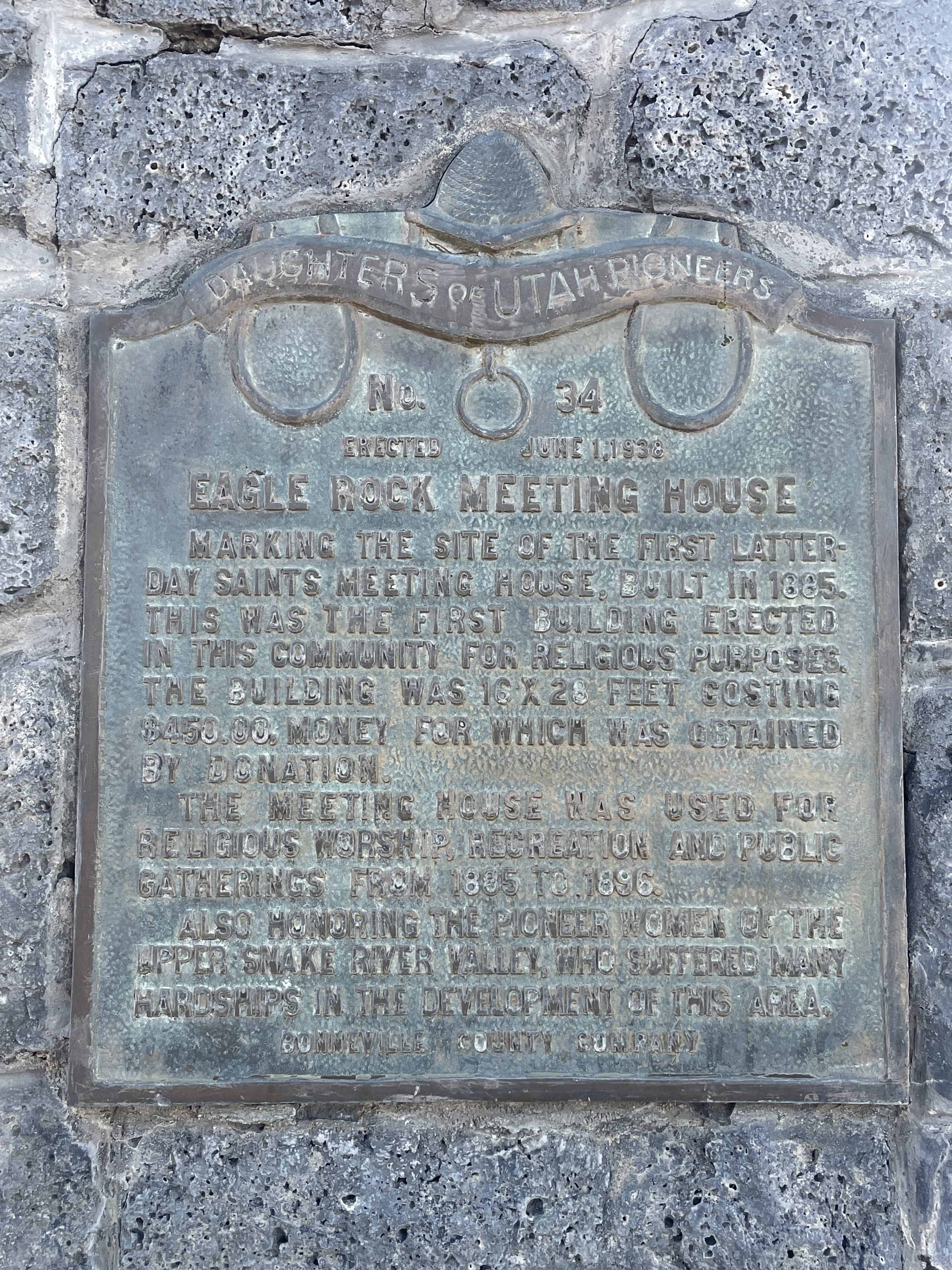
Eagle Rock Meeting House
Marking the site of the first Latter-Day Saints meeting house, built in 1885. This was the first building erected in this community for religious purposes. The building was 16 X 28 feet costing $450.00, money for which was obtained by donation.
The meeting house was used for religious worship, recreation and public gatherings from 1885 to 1896.
Also honoring the pioneer women of the Upper Snake River Valley, who suffered many hardships in the development of this area.
Daughters of Utah Pioneers historic marker #39, erected June 1, 1938 and located along the Idaho Falls Greenbelt Trail near the intersection of Riverside Drive, Memorial Drive and E Street in Idaho Falls, Idaho.
(The Drown Log Cabin marker also has #34 on it, but it is #39 on the DUP’s list.)
These photos provided by Marshall Hurst:

19 Friday May 2023
Posted in Uncategorized
Upper Snake River Valley Irrigation
The fertile soil and abundance of water in this valley lured pioneer settlers. With small slip scrapers, hand plows, picks and shovels, they cleared sagebrush, built log homes, made canals, ditches and dams to put water on the land. One of the first canals was built in 1879-1880. Rock and brush dams were built to divert water into headgates. Men lost their lives in this work. Later canals were enlarged and better dams built. The largest dam, known as the “Great Feeder”, completed June 22, 1895, diverts water from South Fork into a network of canals. Through consolidation of canal systems, 700,000 acres of irrigated land with 100 canals, known as the Upper Portion of District No.36, are using 4,150,000 acre feet of water from the river and its tributaries each irrigation season. Here the dream of reclaimed desert has been brought to full fruition. This is the legacy left by those pioneers to present and future generations.
Daughters of Utah Pioneers historic marker #228, erected in 1956 and located along the Idaho Falls Greenbelt Trail near the intersection of Riverside Drive, Memorial Drive and E Street in Idaho Falls, Idaho.
These photos provided by Marshall Hurst:


06 Friday Jan 2017
Posted in Uncategorized

Idaho Falls Posts:
What became Idaho Falls was the site of Taylor’s Crossing on the Montana Trail which was a timber frame bridge built across the Snake River. The 1865 bridge was built by Matt Taylor who was a Montana Trail freighter who built a toll bridge across a narrow black basaltic gorge of the river that succeeded a ferry seven miles upstream by several years. Taylor’s bridge served the new tide of westward migration and travel in the region that followed the military suppression of Shoshone resistance at the Bear River Massacre near Preston, Idaho in 1863. The bridge improved travel for settlers moving north and west and also for miners, freighters, and others seeking riches in the gold fields of Idaho and Montana and especially the boom towns of Bannack and Virginia City in western Montana.
29 Thursday May 2014
Posted in Uncategorized
Tags
Snake River Bridge
Erected May, 1953
On December 10, 1864 a franchise was granted to Edward M. Morgan, James M. ( Matt ) Taylor, and William F. Bartlett to operate a ferry one and one-half miles below Cedar Island and build a bridge over Snake River at Black Canyon. Mr. Taylor selected the bridge and in 1864-65 erected an 83 foot wooden span with solid rock anchorage on both sides. It was a modified Queens Truss type. This first bridge to cross Snake River was located 1320 feet south of this spot. A replica of the bridge tops this monument.
Bonneville County, Idaho

Check out all of the historic markers placed by the Daughters of Utah Pioneers at JacobBarlow. com/dup
29 Thursday May 2014
Posted in Uncategorized
Tags

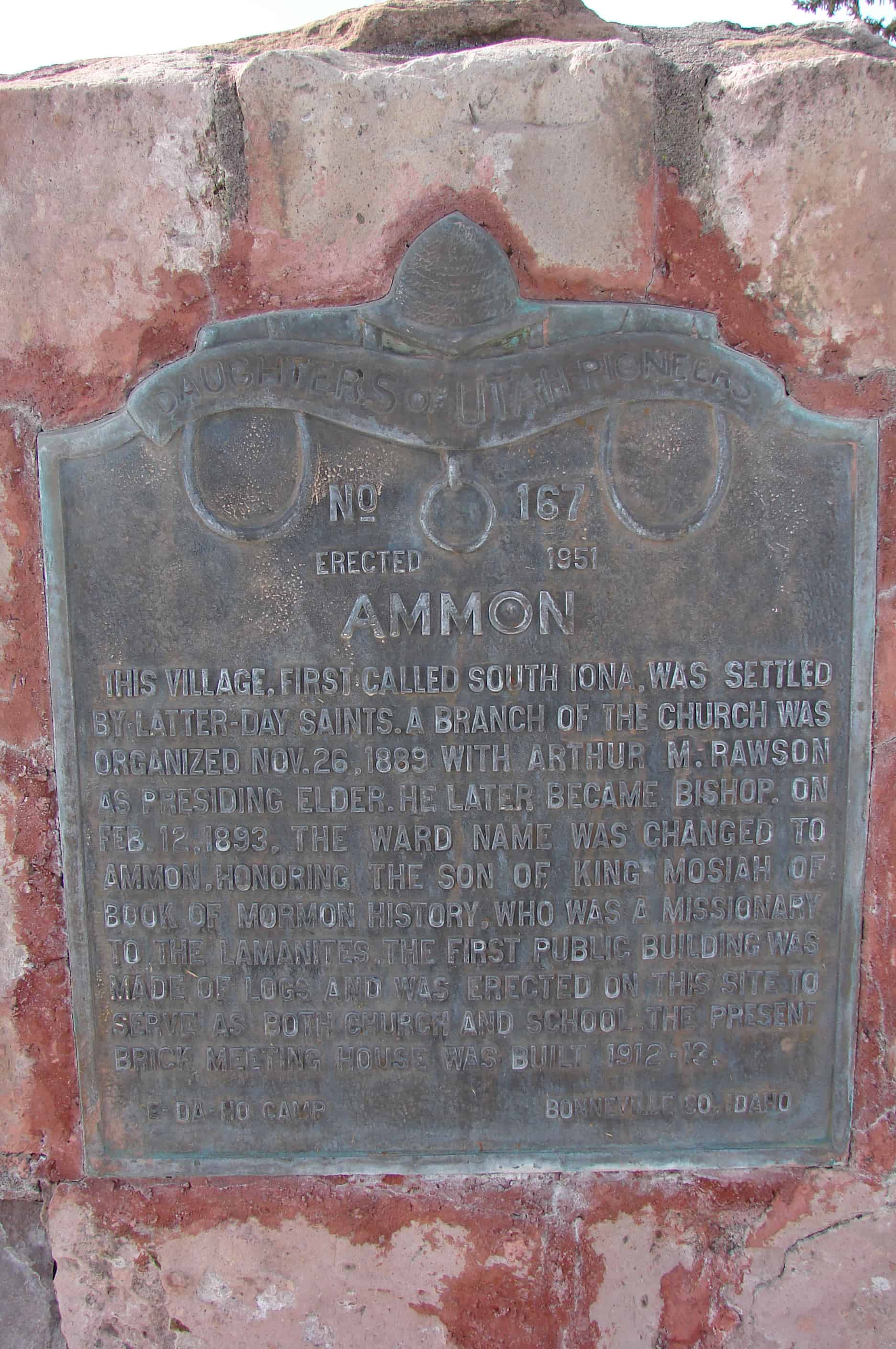
This village, first called South Iona, was settled by Latter-Day Saints. A Branch of the Church was organized Nov. 26, 1889 wit Arthur M. Rawson as presiding Elder. He later became Bishop. On Feb. 12, 1893, the Ward name was changed to Ammon, honoring the son of King Mosiah of Book of Mormon history who was a missionary to the Lamanites. The first public building was made of logs and was erected on this site to serve as both church and school the present brick meeting house was built 1912-13.
Located in Ammon, Idaho.
Check out all of the historic markers placed by the Daughters of Utah Pioneers at JacobBarlow. com/dup