The town of Spring Canyon, or Storrs as it was originally called, was the site of the first coal mine in Spring Canyon. A small mine was worked in Sowbelly Gulch by Teancum Pratt beginning in about 1895, then in 1912 “Uncle” Jesse Knight purchased the mine and hired George Storrs to develop the operation. By 1913 a railroad was completed from Helper, 60 stone houses, a store, hotel and hospital had been built for the miners and the mine was extracting coal. By 1914 the mine was producing about 1,000 tons per day. In 1924 the town was renamed Spring Canyon and sported a modern water and sewer system, heated swimming pool and tennis courts. By 1940 the Spring Canyon Mine was ranked as the fourth largest coal producer in the state. In 1947 the town reached its height when a population of over 1,000. In early 1970 the mine was completely closed, the last 37 miners were unemployed and the town was abandoned.*
Peerless, just 3 miles west of Helper, was the first mine developed in the Spring Canyon District. The property was purchased in 1916 by brothers William and Charles Sweet. They developed the coal operation including a gravity tramway and a tipple on the canyon floor.
In 1917 the Sweet brothers sold the property to the Peerless Coal Company organized by James Murdoch and Ezra Thompson. Robert Howard, a former mine inspector was the first superintendent. Coal production peaked during World War I at 2000 tons per day. At the end of the war, they had contracts to ship coal to Idaho, Washington, Oregon, the Hawaiian Islands and were producing 500 tons of coal per day. During the boom the coal produced paid for the project and cleared a bonded indebtedness of $400,000. By 1920 the mine was free from outstanding obligations.
At its peak the town of Peerless was home to around 300 people of which 150 were miners. It consisted of about 30 houses, a store, a school, the company mine office, a post office, a pool hall, and a clubhouse for company officials.
In July 1930 the Peerless Coal Company discontinued operations due to low production and high production costs. Peerless Coal Company declared bankruptcy the following year.
In August 1931, the mine was leased to former superintendent Robert Howard and Robert Turner. Utilizing new mining technology that reduced costs they began shipping coal in September of 1931. Less than a year later, in May of 1932, the mine was taken over by the Peerless Sales Company. Around 1938 coal mining activity began to decline and people began to move away. After World War II the mine operated sporadically, and few residents remained.
The mine closed in 1953, its assets were sold, and the last residents left.*
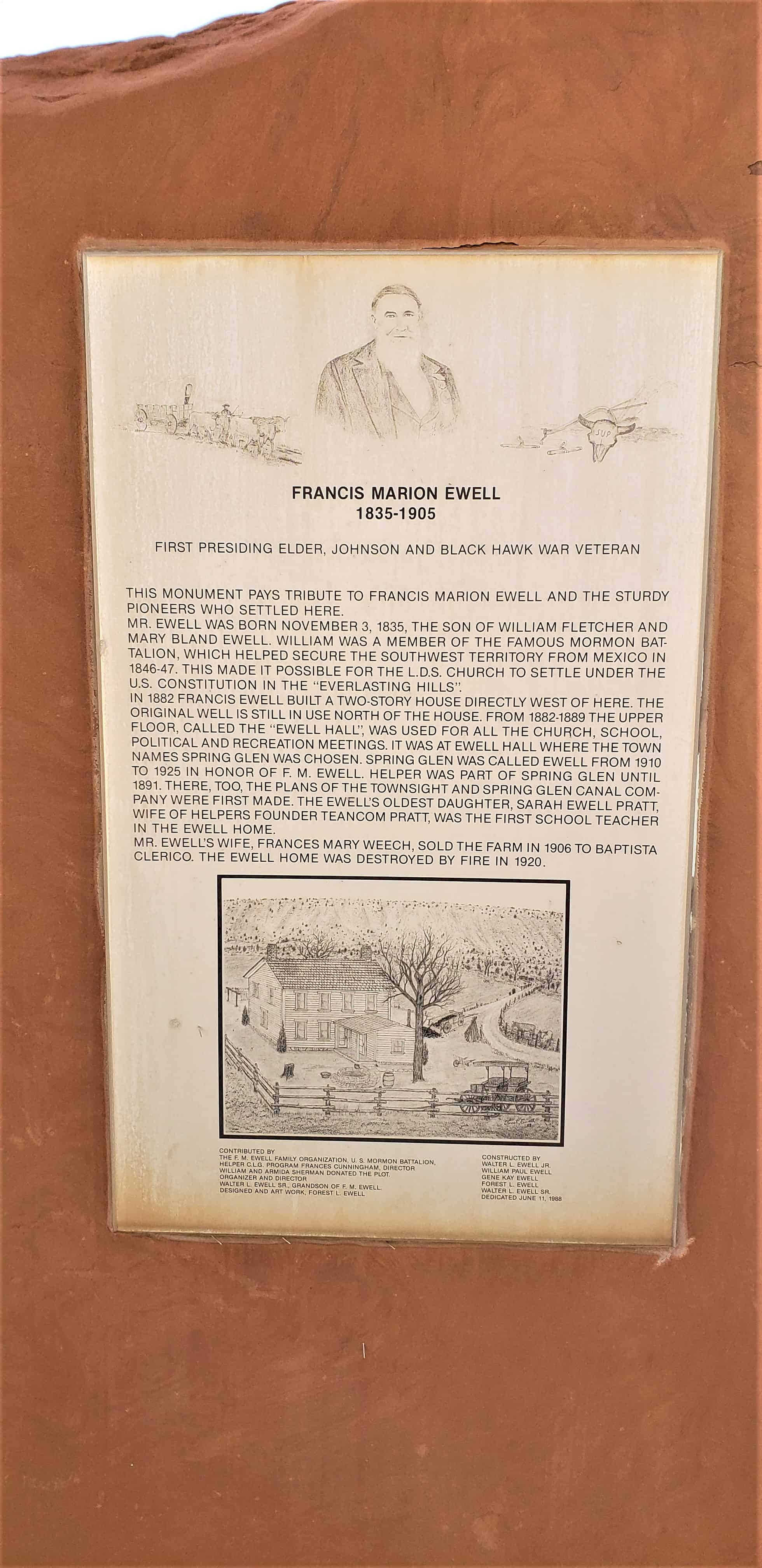
First Presiding Elder, Johnson and Black Hawk War Veteran
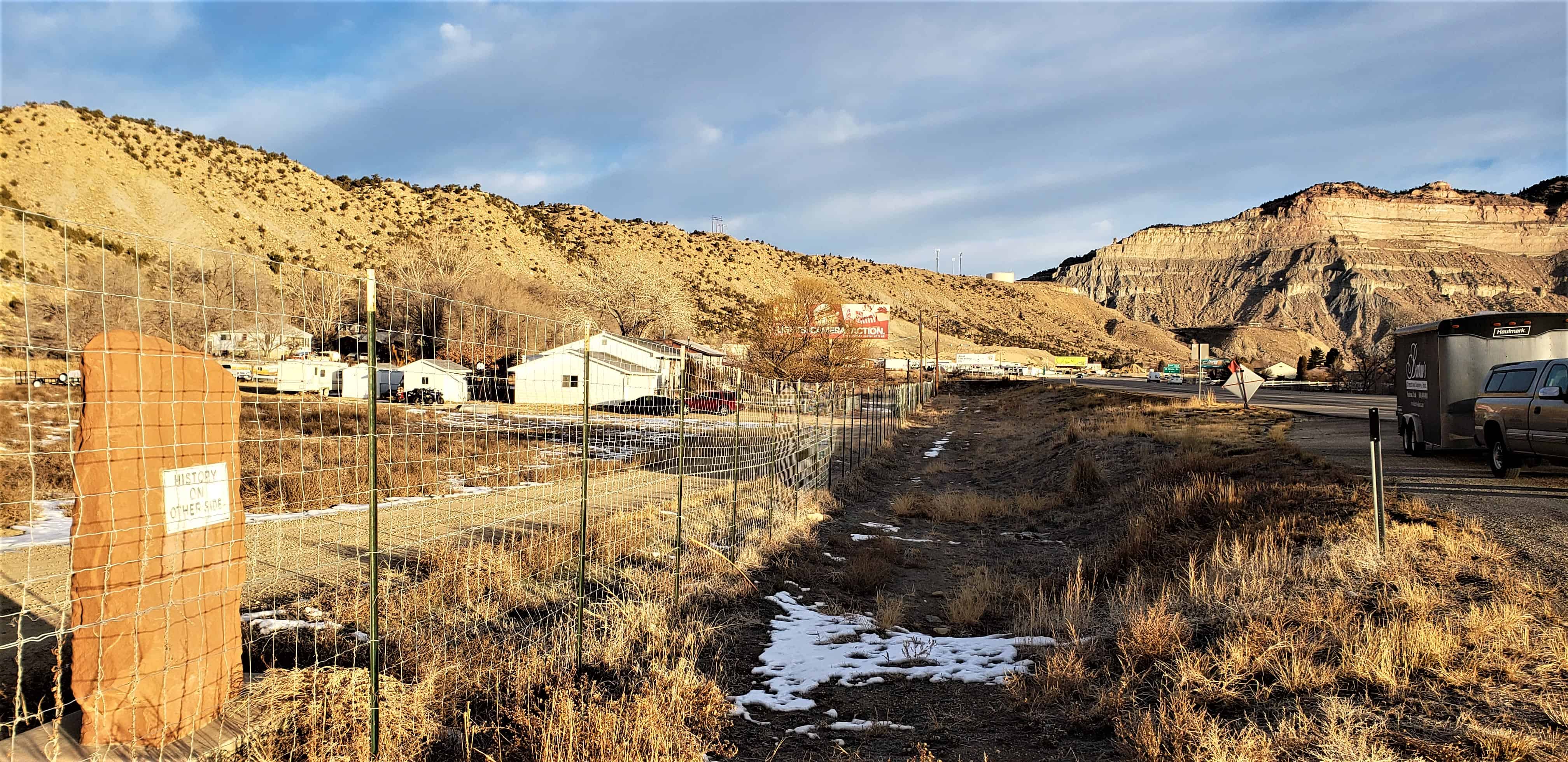
This monument pays tribute to Francis Marion Ewell and the sturdy pioneers who settled here.
Mr. Ewell was born November 3, 1835, the son of William Fletcher and Mary Bland Ewell. William was a member of the famous Mormon Battalion, which helped secure the southwest territory from Mexico in 1846-47. This made it possible for the L.D.S. Church to settle under the U.S. Constitution in the “everlasting hills”.
In 1882 Francis Ewell built a two-story house directly west of here. The original well is still in use north of the house. From 1882-1889 the upper floor, called the “Ewell Hall”, was used for all the church, school, political and recreation meetings. It was at Ewell Hall where the town name Spring Glen was chosen. Spring Glen was called Ewell from 1910 to 1925 in honor of F.M. Ewell. Helper was part of Spring Glen until 1891. There, too, the plans of the townsite and Spring Glen Canal Company were first made. The Ewell’s oldest daughter, Sarah Ewell Pratt, wife of Helper’s Founder Teancom Pratt, was the first school teacher in the Ewell home.
Mr. Ewell’s wife, Frances Mary Weech, sold the farm in 1906 to Baptista Clerico. The Ewell home was destroyed by fire in 1920.
We hold in sacred memory those sturdy and brave pioneer women, who left their homes in the Eastern United States or sailed from the foreign lands; that trekked across hills, plains, and mountains, forded streams and rivers, birthed and buried loved ones along the trail. Others followed, with faith in every footstep, arriving in Price River Valley. Contributing their ethnic traditions and religious beliefs; each endured hardship to conquer this desert, make a home, provide for their posterity and contribute to the settlement.
The women hoed and helped husbands, fathers, sons and daughters to prepare the soil and plant. They prayed for sun and rain, in turn; fought off crickets, grasshoppers or prairie fires in order to save their crops. They harvested, gleaned, and ground wheat on gristmill stones, lovingly shaped loaves of bread and baked in earthen ovens. They blessed and broke bread, together, as families and friends.
In honor of these pioneer women’s contributions, in June of 1928, Price’s Mayor, W. F. Olson, deeded DUP land for the Pioneer Evergreen Park. Price Company Daughters of Utah Pioneers, their families, and Boy Scouts of America cleared the area and prepared for the monument and statue to be erected. Local artist, Dean Fausett, created an original statue of a pioneer woman in a walking position, dressed in a long dress with a bonnet hanging down her back, and a sack of grain over her left arm, to adorn the top of a rock cairn built by Dan Morley. The dedicatory prayer for the original monument was offered by Bishop George Jorgensen, September 7, 1931. Years later, the cement statue and bronze markers disappeared.
In 2009, a search began to locate the monument’s history. DUP minutes revealed that the original statue was modeled after Florence Virginia Horsley Jorgensen. News articles and photographs were provided to Gary Prazen, a local sculptor, to recreate the replica in enduring bronze. Richard Morley, repaired the original rock monument.
Price City Centennial Year Celebration of 2011 marks the rededication of Price Company Daughters of Utah Pioneer’s efforts to restore “Pioneer Women” to honor all women residing in this multinational community, united in their preservation of the past and dedicated to prepare for Price’s future.
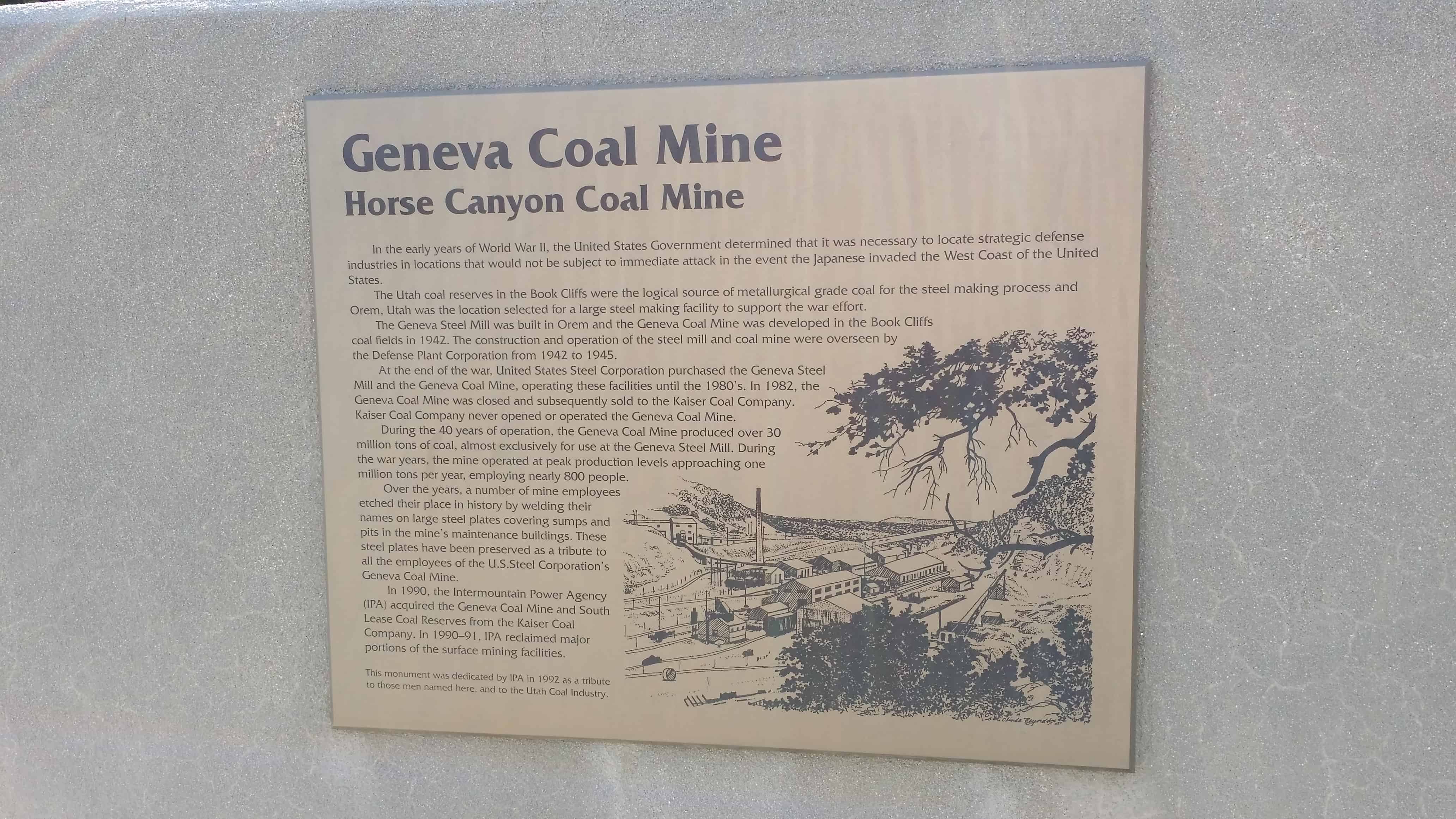
In the early years of World War II, the United States Government determined that it was necessary to locate strategic defense industries in locations that would not be subject to immediate attack in the event the Japanese invaded the West Coast of the United States.
The Utah coal reserves in the Book Cliffs were the logical source of metallurgical grade coal for the steel making process and Orem, Utah, was the location selected for a large steel making facility to support the war effort.
The Geneva Steel Mill was built in Orem and the Geneva Coal Mine was developed in the Book Cliffs coal fields in 1942. The construction and operation of the steel mill and coal mine were overseen by the Defense Plant Corporation from 1942 to 1945.
At the end of the war United States Steel Corporation purchased the Geneva Steel Mill and the Geneva Coal Mine, operating these facilities until the 1980’s. In 1982, the Geneva Coal Mine was closed and subsequently sold to the Kaiser Coal Company. Kaiser Coal Company never opened or operated the Geneva Coal Mine.
During the 40 years of operation the Geneva Coal Mine produced over 30 million tons of coal, almost exclusively for use at the Geneva Steel Mill. During the war years the mine operated at peak production levels approaching one million tons per year, employing nearly 800 people.
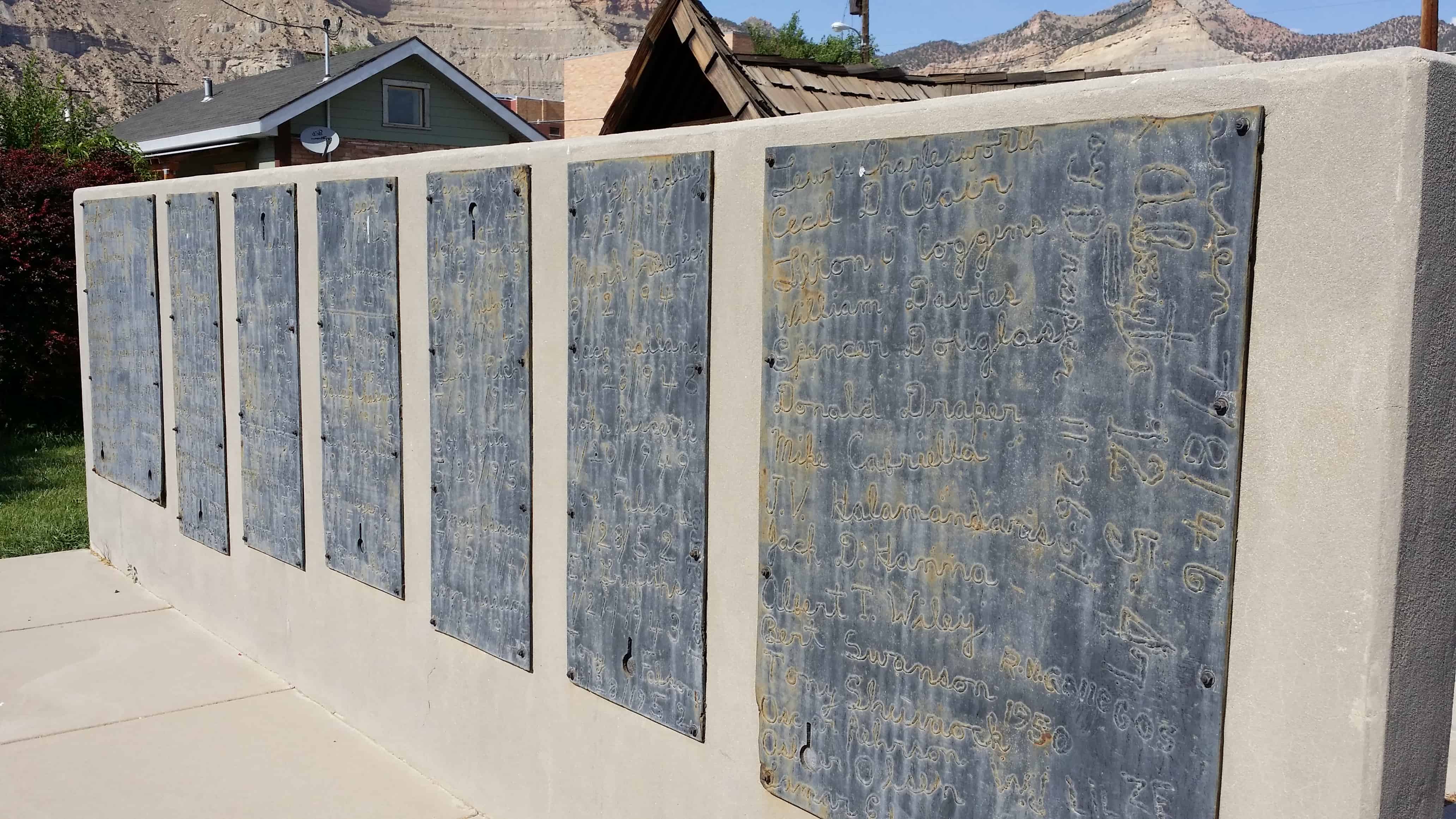
Over the years, a number of mine employees etched their place in history by welding their names on large steel plates covering sumps and pits in the mines maintenance buildings. These steel plates have been preserved as a tribute to all employees of the U.S. Steel Corporation’s Geneva Coal Mine
In 1990 the Intermountain Power Agency (IPA) acquired the Geneva Coal Mine and South Lease coal Reserves from the Kaiser Coal Company. In 1990-91 IPA reclaimed major portions of the surface mining facilities.
This monument dedicated by IPA in 1991 as a tribute to those men named here and to the Utah Coal Industry.
12 STEEL PLAQUES CONTAIN WELDED NAMES OF MINE EMPLOYEES
Carbonville was one of the very first settlement sites in what became Carbon County. Caleb Rhoades built a dugout here in 1877, before moving on to found Price in 1879. Later called “Rhoades Meadow”, the place had plenty of water, but of poor quality.
The village grew slowly, with most immigrants preferring the more developed areas of Price and Spring Glen. Carbonville did experience rapid growth in the industrial and housing boom years after World War II. The Church of Jesus Christ of Latter-day Saints organized the first ward here in the late 1940s, and a second one in the 1950s.
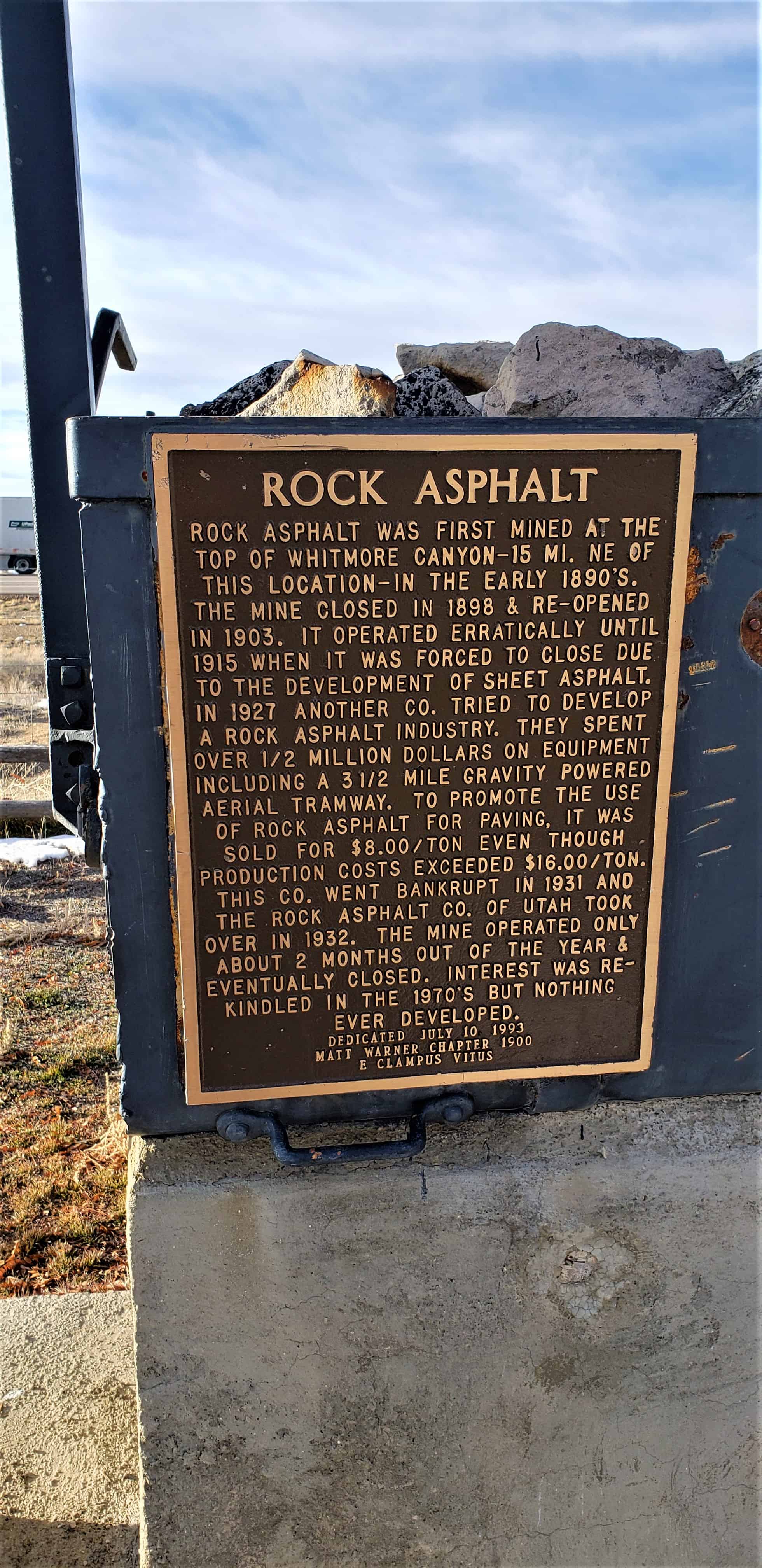
Rock asphalt was first mined at the top of Whitmore Canyon – 15 mi. NE of this location – in the early 1890’s. The mine closed in 1898 & re-opened in 1903. It operated erratically until 1915 when it was forced to close due to the development of sheet asphalt. In 1927 another Co. tried to develop a rock asphalt industry. They spent over 1/2 million dollars on equipment including a 3 1/2 mile gravity powered aerial tramway. To promote the use of rock asphalt for paving, it was sold for $8.00/ton even though production costs exceeded $16.00/ton. The Rock Asphalt Co. of Utah took over in 1932. The mine operated only about 2 months out of the year & eventually closed. Interest was rekindled in the 1970’s but nothing ever developed.
Utah’s Asphalt Production Process Is One of Country’s Most Interesting
Sun Advocate – October 9, 1947
Every story of western mining carries with it a hint of romanticism and the spirit of adventure that cannot be found in any other industry in the world. The history of brave men with visions of the good that can be derived from the hidden treasures of nature has always been and probably will continue to be a source of inspiration to those whose walks of life have carried them into the other fields of endeavor. There is something of a mystery about mining, whether underground or above, and one can’t help but wonder at the strength of those who planned the industry into what it is today. Utah’s position as one of the leading states in the production of minerals is well know. Within its borders are found nearly every mineral of commercial importance. They hydrocarbon deposits of eastern Utah are enormous. Gilsonite and elaterite mines have been developed to a large extent and the products have been shipped to many parts of the world. Some of these hydrocarbons are perculiar, in that Utah is the only place in the world known where they are found. Among the many natural resources Utah has within its borders is the deposit of rock asphalt found east of Sunnyside. This deposit is the largest and richest of natural rock asphalt in the United States and, perhaps, in the world. There are many deposits of rock asphalt within the United States and several plants are now processing large tonnage from those deposits for use in street and road constuction.
The Utah deposit which is owned by the Rock Asphalt company of Utah is estimated to contain some 800 million tons. It is estimated that the deposit contains enough rock asphalt to build three 64 foot roads completely encircling the globe. The Sunnyside quarry is probably one of the most interesting in the country. Located 9,040 feet above sea level, the mineral is scooped out of the side of the mountain by huge shovels and is transported to the crushers in the valley eight miles away by means of huge buckets suspended on cables. The mountain in which the deposit is located is 10,000 feet high thus placing the diggings almost to the top. A private road leads to the mine winding up the mountain side and from there continues to top where, incidentally, is a deer hunter’s paradise. To have transported all of the heavy machinery to the quarry on the narrow road is an engineering fete within itself and is a source of wonder to the visitor.
Approximately 200 tons of rock asphalt are produced each nine hour working day from the present opening which ranges in thickness from 40 to 70 feet. Work is now going on to open a new face which is located several feet higher than the present working and which will open a vein ranging in thickness for 70 to 200 feet. The new section will also provide a much richer product. Initial tests have shown it to run at a minimum of 13 per cent bitumen. State specifications call for from 10 to 13 per cent bitumen with less than five per cent moisture content. To obtain the asphalt, holes are drilled in the face and powder is used to blast the mineral loose. It is then loaded into trucks for transportation to the dump where it is picked up by the buckets which carry it down the canyon. The cable carrying the buckets is approximately 14 miles in length, seven miles of carrying cable and seven miles of track cable. Sixty three buckets are in use with the loaded buckets pulling the empties back to the mine. Each bucket carries 1200 pounds of asphalt and the round trip for each bucket takes 1 1/2 hours. The mineral goes through a primary crusher before entering the buckets and is dumped into a storage bin at the bottom of the canyon. From here it is transported by trucks to the crusher at Sunnyside there it goes through two different sets of rolling mills before going through the final crushing process in a hammer mill. When the process has been completed the asphalt comes out of the mill in the form of powder as fine as flour. At this point it is loaded into railroad cars and trucks for distribution throughout the country. Each shipment is tested prior to distribution.
According to Eugene Pressett, superintendent of the Sunnyside operations, experiments are now being carried on by adding an oil emulsion to the crushed asphalt to develop a product that will withstand the lowest temperatures. Rock asphalt, or bituminous sandstone as it is commercially known, is a mixture of asphalt and sand compressed by nature into hard rock which was formed by liquid oil, with an asphalt base, accumulating underground in some kind of geological trap. The sand which was originally laid down as a marine sand of fine and uniform texture was then covered in this manner by a pool of asphaltic base oil, which, due to extreme underground heat and pressure, allowed the bolatile matter to escape leaving a residue of pure asphaltum permeating this stratum of marine sand. This was followed by additional natural formative pressure which caused the sand to be completely permeated by and coated with asphalt to an average of about 10 per cent asphaltum and 90 percent pure silics sand. These sand particles are not merely suspended in the asphalt but every void and pore of the sand is permeated with asphaltum so that a complete breakdown of one grain of sand would give an assay comparable to a larger or average piece of rock asphalt. Rock asphalt roads have been in use for many years. In fact, the first paved roads built in the world were of rock asphalt. History reports Paris built its first paved road of this material in 1854. The first paved street in the United States was built in 1872 in Union Square, New York City, of rock asphalt brought from Switzerland. The first street paved in Utah was old Commercial street in Salt Lake City and this was built in 1891 with rock asphalt brought from Santa Cruz, California. This started the development of the Utah deposits and in 1892 Richard street in Salt Lake City was paved with Utah rock asphalt and has been in continuous use for 17 years. The history of rock asphalt shows that it is the oldest known paving material and has been in continuous use since 1854. At the present time, work is being completed on the laying of asphalt on every street in Dragerton including the driveways into every yard. Approximately 8000 tons of the material has been used on this project.
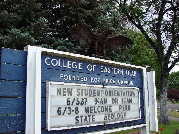
Carbon College was formed on February 20, 1937 by the State of Utah and classes began in October 1938 with approximately 100 students. The newly formed college faced financial difficulties in 1953 when a budget-cutting measure was proposed to dismantle the college and sell the property. The issue went to the ballot during the election of 1954 with 56,000 petition signatures and a subsequent 78% of the vote to reject such a measure.
In 1959, the college was joined with the University of Utah and acted as a branch of the University for 10 years. During the partnership, the campus grew significantly and the college became known as College of Eastern Utah (CEU). During the 1960s, CEU added several new buildings including the Geary Theater, Music Building, Science Center, and Library. In 1969, the Utah System of Higher Education was created ending the relationship between the University of Utah and CEU.
During the 1970s, CEU began to focus on the mission of being a vocational-technical school for the community. Degrees were expanded to include welding, automotive mechanics, machine shop, cosmetology, diesel mechanics, and a registered nursing program. CEU expanded courses to be taught at the San Juan Center. After the start of the 21st century, courses and enrollment began to climb to more than 2,000 students enrolled in more than 400 courses.
In 2010, the College of Eastern Utah merged with Utah State University creating Utah State University Eastern (USU Eastern). Shortly after the merger, Dr. Joe Peterson, a former vice president of instruction at Salt Lake Community College, became the school’s first chancellor, reporting directly to USU president Stan L. Albrecht.