• About JacobBarlow.com
  • Cemeteries in Utah
  • D.U.P. Markers
  • Doors
  • Exploring Utah Email List
  • External and Referral Links
  • Geocaching
  • Historic Marker Map
  • Movie/TV Show Filming Locations
  • Oldest in Utah
  • Other Travels
  • S.U.P. Markers
  • U.P.T.L.A. Markers
  • Utah Cities and Places.
  • Utah Homes for Sale
  • Utah Treasure Hunt

JacobBarlow.com

~ Exploring with Jacob Barlow

JacobBarlow.com

Tag Archives: Spanish Explorers

Homeward Bound

13 Friday Mar 2020

Posted by Jacob Barlow in Uncategorized

≈ Leave a comment

Tags

Escalante y Dominguez, Historic Markers, Hurricane, Spanish Explorers, utah, Washington County

Homeward Bound

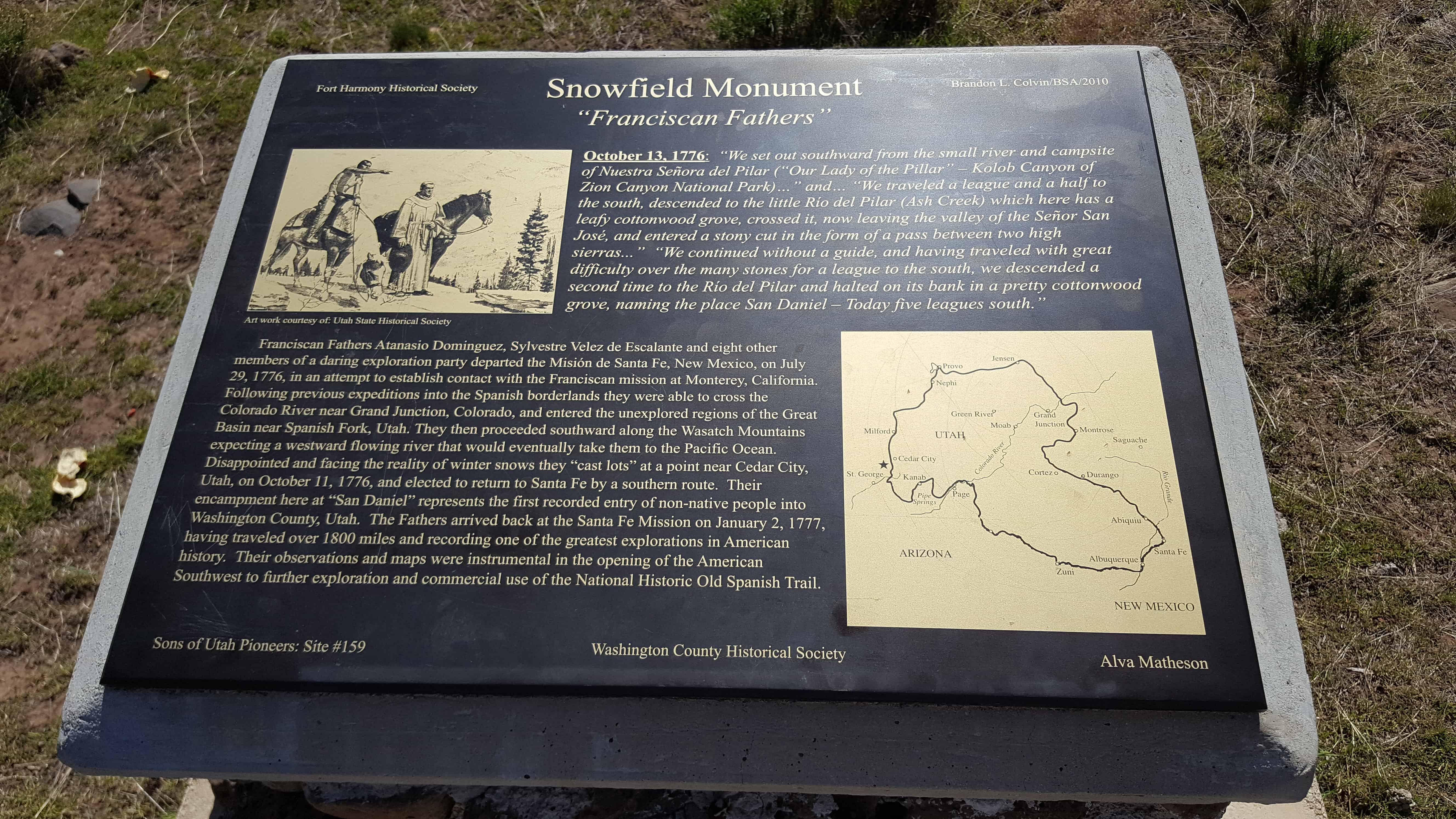
On July 29, 1776, Fathers Francisco Atansio Dominguez and Silvestre Velez de Escalante led an exploration party of ten horsemen from Santa Fe, New Mexico to establish an overland route to Monterey, California while spreading the Catholic faith to the native peoples they hoped to meet along the way.

On October 14, the expedition camped at San Hugelino in present day Toquerville. The previous day, the two Indian guides, suspicious and afraid of the Spaniards, led them into the hills west of Ash Creek Canyon and disappeared, leaving the padres to find their way out the best they could. The Spaniards found their way back to Rio del Pilar 9Kanarra Creek) with great difficulty and camped there at San Daniel.

Two days later, as the party traveled south near present day Hurricane they came upon three small corn fields, watered by irrigation ditches Since they had nothing left but two slabs of chocolate, this meant provision could be secured on the return trip to Santa Fe. The community orientation of these Indians also meant that the chances for success in teaching Christianity to them were good.

Although the expedition never reached California, they covered some 2,000 miles of challenging terrain, adding greatly to the knowledge of the geography and the native inhabitants of the Spanish domain now called the American Southwest.

This marker is located just outside the Hurricane Pioneer Museum in Hurricane, Utah

Domínguez and Escalante

19 Thursday Dec 2019

Posted by Jacob Barlow in Uncategorized

≈ Leave a comment

Tags

Escalante y Dominguez, Spanish Explorers

Spanish explorers Silvestre Vélez de Escalante and Atanasio Domínguez were looking for a good ruote from Santa Fe, New Mexico to Monterey, California and I often come across historic markers and sites related to their travel.

I created this page so I can continually add links to the sites I find related to Escalante y Domínguez.

  • Burraston Ponds (camped here Sep 27, 1776)
  • Castilla Hot Springs (they discovered the springs in 1776)
  • Dominguez Hill Cross (above Spanish Fork)
  • Dominguez y Escalante Expedition (Spanish Fork)
  • Escalante (city named for Father Escalante)
  • Escalante Cross above Spanish Fork
  • Escalante Trail (Delta)
  • Escalante Trail (Provo)
  • Father Escalante (Duchesne)
  • Homeward Bound (Hurricane)
  • The Lush Valley of the Timpanogotzis (Spanish Fork)
  • Paragonah Town Square (the expedition passed this area)
  • Provo’s Name Has an Interesting History (named the lake and river)
  • Silvestre Vélez de Escalante
  • Snowfield Monument “Franciscan Fathers”
  • Soldier Summit Historic Marker
  • Southern Utah Valley
  • Spanish Fathers Visit Utah Valley in 1776 (Provo)
  • Spanish Fork City Park and Library (camped near here, Sep 23, 1776)

Snowfield Monument “Franciscan Fathers”

25 Tuesday Apr 2017

Posted by Jacob Barlow in Uncategorized

≈ 1 Comment

Tags

historic, Historic Markers, Snowfield, Spanish Explorers, Spanish Trail, SUP, utah, Washington County

2017-03-19 15.34.56

October 13, 1776: “we set out southward from the small river and campsite of Nuestra Señora del Pilar (“Our Lady of the Pillar” – Kolob Canyon of Zion Canyon National Park)…” and “We traveled a league and a half to the south, descended to the little Río del Pilar (Ash Creek) which here has a leafy cottonwood grove, crossed it, now leaving the valley of the Señor San José and entered a stony cut in form of a pass between two high sierra…” “We continued without a guide, and having traveled with great difficulty over the many stones for a league to the south, we descended a second time to the Río del Pilar and halted on its bank in a pretty cottonwood grove, naming the place San Daniel – Today five leagues south.”
Franciscan Fathers Atanasio Dominguez, Sylvestre Velez de Escalante and eight other members of a daring exploration party departed the Misión de Santa Fe, New Mexico on July 29, 1776, in an attempt to establish contact with the Franciscan mission at Monterey, California. Following previous expeditions into the Spanish borderlands they were able to cross the Colorado River near Grand Junction, Colorado, and entered the unexplored regions of the Great Basin near Spanish Fork, Utah. They then proceeded southward along the Wasatch Mountains expecting a westward flowing river that would eventually take them to the Pacific Ocean. Disappointed and facing the reality of winter snows they “cast lots” at a point near Cedar City, Utah, on October 11, 1776, and elected to return to Santa Fe by a southern route. Their encampment here at “San Daniel” represents the first recorded entry of non-native people into Washington County, Utah. The Fathers arrived back at the Santa Fe Mission on January 2, 1777, having traveled over 1800 miles and recording one of the greatest explorations in American history. Their observations and maps were instrumental in the opening of the American Southwest to further exploration and commercial use of the National Historic Old Spanish Trail.

See other historic markers in the series on this page for SUP Markers.

2017-03-19 15.35.04

2017-03-19 15.35.10


2017-03-19 15.35.20
2017-03-19 15.35.25
2017-03-19 15.35.53

2017-03-19 15.35.44

2017-03-19 15.36.07

The Spanish Trail

09 Sunday Oct 2016

Posted by Jacob Barlow in Uncategorized

≈ Leave a comment

Tags

Carbon County, History, San Rafael Swell, Spanish Explorers, utah

  • picture18apr08-004

The Spanish Trail – 1800-1850

From this point the trail ran westward through the Black Hills to a grove of trees on Huntington Creek.

  • 34decb15-a20c-4441-a69a-c87cbb77ed3b

Dominguez y Escalante Expedition

11 Monday Aug 2014

Posted by Jacob Barlow in Uncategorized

≈ 4 Comments

Tags

historic, Spanish Explorers, spanish fork, utah, utah county

On July 29, 1776, Fathers Dominguez and Escalante with their party of 10
left Santa Fe, New Mexico, to find a new route to Monterey, California. After nearly 1000 miles they and their two native guides reached the mouth of Spanish Fork Canyon on Sept. 23, 1776. They climbed a hill and caught sight of the lake and spreading valley rimmed by Yuta Timpanogotzis Indian villages. They named it the Valley And Lake Of Our Lady Of Mercy Of The Timpanogotzis. They stayed in the valley four days meeting with the Indians and teaching them about Christianity and their salvation.

The hill the Padres climbed to see the valley was dedicated as Dominguez
Hill 200 years later in 1976. A 37 Ft. high cross was erected on that hill and dedicated In 1981. The hill and cross can be seen by looking in a S-SW direction or by using the viewer. The cross is on private property and is not accessible.

There is a historic Marker and some pipes set to look through and see the cross set up in 1981.
2cf9f2cd-179d-4ef5-b280-e6d44f60067d

  • 9092a761-def1-4a2b-a690-2605e4668162
  • 3242222d-e93b-4ce9-b4e1-c44f74e84fab
  • d2ea9b3e-54dc-454a-8867-1900c73f48af
  • ead8d22a-281f-4641-8ed1-eba7770a6047

Escalante Trail

18 Wednesday Jun 2014

Posted by Jacob Barlow in Uncategorized

≈ 1 Comment

Tags

historic, Provo, Spanish Explorers, SUP, utah, utah county

2018-10-27 17.15.02

(Just outside the Historic Utah County Courthouse)

There are two plaques on this monument:

ESCALANTE TRAIL
Fray Francisco Silvestre Velez De Escalante and Fray Francisco Atanasio Dominguez, two Catholic Priests of the Franciscan Order accompanied by their attendants
Don Juan Pedro Cisneros                                   Lucrecio Muniz
Don Dernardo Miera Y Pacheco                       Andres Muniz
Don Joaquin Lain                                                  Juan De Agulia
Lorenzo Olivares                                                  Simon Lucero

Encamped near here September 24, and 25, 1776, to open a wider field for mission work among the Indians. They were seeking an overland route from Santa Fe New Mexico to Monterey California.

These Priests were the first white men to enter what is now the State of Utah and the first to give us a written record of the geography of the country and the character of its people.

THIS STONE
Contributed to Provo City by the children of the Provo City Schools September 25, 1931

See other historic markers in the series on this page for UPTLA/SUP Markers.

2018-10-27 17.15.14

2018-10-27 17.15.25

Image

Image

Image

2013-06-02 17.12.04

2013-06-02 17.12.11

2013-06-02 17.13.30

2013-06-02 17.13.36

40.232622-111.657931

Follow Jacob

Follow Jacob

Social and Other Links

BarlowLinks.com

Blog Stats

  • 803,020 hits

Recent Posts

  • 356 W 100 N
  • A Firebug Bit Provo in 1878
  • Pony Express Division Headquarters
  • 100th Anniversary – Salt Lake Tribune
  • Site of a Pony Express Station

Archives


Loading Comments...