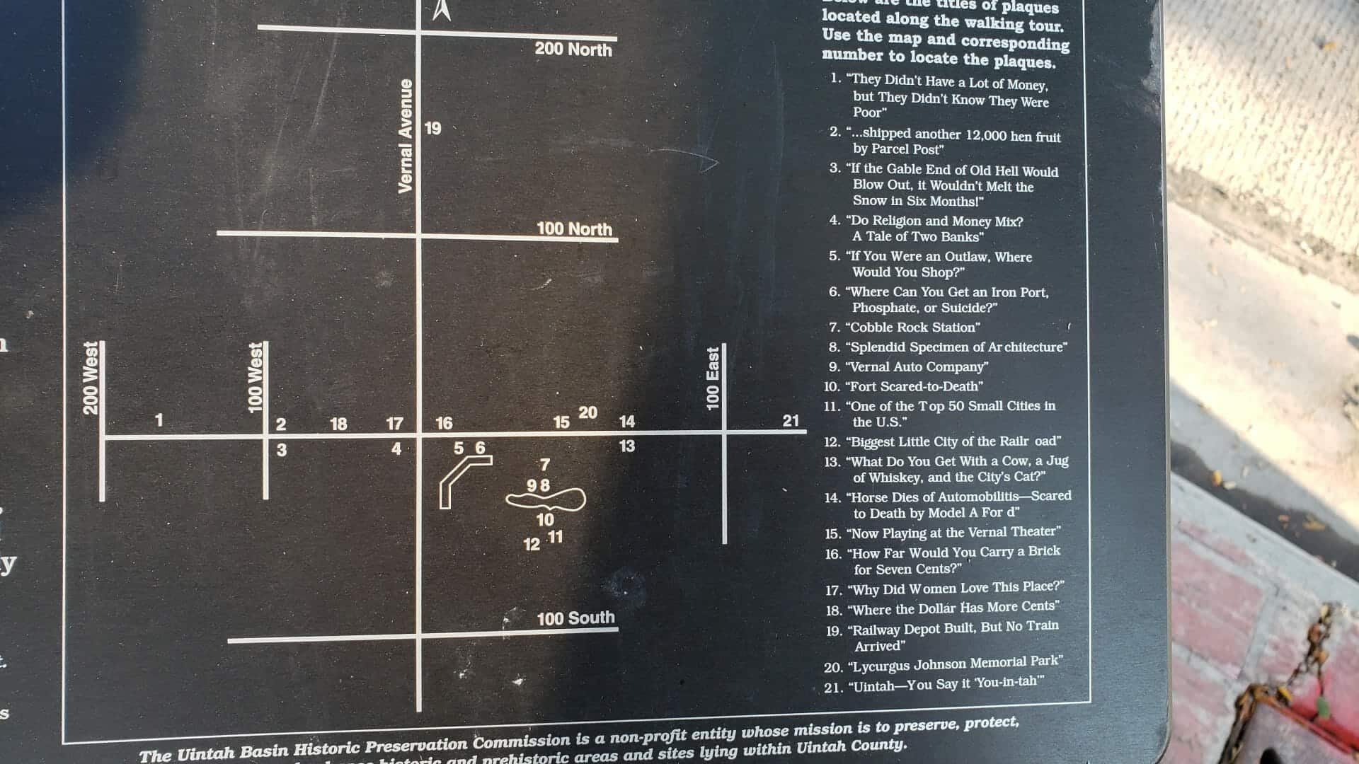
• A Million Meals
  • About JacobBarlow.com
  • Cemeteries in Utah
  • D.U.P. Markers
  • Doors
  • Exploring Utah Email List
  • External and Referral Links
  • Geocaching
  • Historic Marker Map
  • Movie/TV Show Filming Locations
  • Oldest in Utah
  • Other Travels
  • Photos Then and Now
  • S.U.P. Markers
  • U.P.T.L.A. Markers
  • Utah Cities and Places.
  • Utah Homes for Sale
  • Utah Treasure Hunt

JacobBarlow.com

~ Exploring with Jacob Barlow

JacobBarlow.com

Tag Archives: History

The Last Hurdle

19 Monday Dec 2022

Posted by Jacob Barlow in Uncategorized

≈ Leave a comment

Tags

History, Railroad

The Last Hurdle

On the weathered hillside above you are the footprints of fierce rivals, straining for the finish line in the greatest race of the 19th century.

The stakes were high. Each mile of track laid down meant enormous land grants and hefty federal subsidies. Blasting up from California came the Central Pacific Railroad, led by four eminent Sacramento businessmen with 10,000 Chinese laborers.

Eastern money and rough immigrant track gangs pushed the Union Pacific Railroad out from Omaha, barreling across the Plains and through the Rockies.

Both competitors had one last obstacle – the ascent of the Promontory Mountains – the steepest grade east of the Sierra Nevada. In the middle of this tough grade, was the unavoidable 500-foot-wide Spring Creek ravine.

By the spring of 1869, both railroads hurtled over this ravine, each making the leap in its own way.

The Track that United the States

A sharp eye can still pick out the marks of early railroad building along this rugged escarpment, even if the original iron rails and timber ties themselves are gone.

These fading remnants tell the story of a daunting engineering challenge – linking the Western states to the rest of the nation. Inscribed here, amid the sagebrush and bedrock of northern Utah is a tale of grand dreams and brute work, greed and glory.

Strong’s Drugstore

14 Thursday Jul 2022

Posted by Jacob Barlow in Uncategorized

≈ Leave a comment

Tags

California, Central Pacific Railroad Company, Dutch Flat, History, Placer County, Railroad, Transcontinental Railroad

The Central Pacific Railroad Company was founded here in 1860 enabling the completion of the transcontinental railroad.

Strong discovered, and Judah mapped, the once elusive Pacific Route over Donner Summit.

This plaque is located on Main Street in Dutch Flat, California.

Vernal’s Walking History Tour

20 Monday Jun 2022

Posted by Jacob Barlow in Uncategorized

≈ Leave a comment

Tags

History, Tours, Uintah County, utah, Vernal, Walking Tours

Welcome to Vernal’s Walking History Tour

Adjacent to you, as well as within ten minutes walking time from here, are located a total of 21 plaques looking similar to this one in color, size and shape. Mounted on three-foot-tall metal posts and typically located along the street-side of the sidewalk, these plaques illustrate historical events as they occurred over 100 years ago. These plaques reference locations on the opposite side of the street so you can see what the old establishments looked like in their day.

In addition to the six displayed within this, Cobble Rock Park, you can find the remaining plaques by following the map shown here.

What the plaques describe are sometimes the colorful, tragic, humorous, and anecdotal short stories of how Vernal settlers endured, preserved, and creatively entrepreneured to make Ashley Valley their home.

It is by history that we understand the challenges of the past. By our present that we protect it, and by our future that we learn from it. – Anonymous

There is properly no history; only biography. – Ralph Waldo Emmerson

Below are the titles of the plaques located along the walking tour. Click on the title to go to a page about that location/plaque and see photos and descriptions.

  1. “They Didn’t Have a Lot of Money, but They Didn’t Know They Were Poor“
  2. “…shipped another 12,000 hen fruit by Parcel Post“
  3. “If the Gable End of Old Hell Would Blow Out, it Wouldn’t Melt the Snow in Six Months!“
  4. “Do Religion and Money Mix? A Tale of Two Banks“
  5. “If You Were an Outlaw, Where Would You Shop?“
  6. “Where Can You Get an Iron Port, Phosphate, or Suicide?“
  7. “Cobble Rock Station“
  8. “Splendid Specimen of Architecture“
  9. “Vernal Auto Company“
  10. “Fort Scared-to-Death“
  11. “One of the Top 50 Small Cities in the U.S.“
  12. “Biggest Little City off the Railroad“
  13. “What Do You Get With a Cow, a Jug of Whiskey, and the City’s Cat?“
  14. “Horse Dies of Automobilitis – Scared to Death by Model A Ford”
  15. “Now Playing at the Vernal Theater“
  16. “How Far Would You Carry a Brick for Seven Cents“
  17. “Why Did Women Love This Place?“
  18. “Where the Dollar Has More Cents“
  19. “Railway Depot Built, But No Train Arrived!“
  20. “Lycurgus Johnson Memorial Park“
  21. “Uintah – You Say it ‘You-in-tah’ “

This walking tour is located in downtown Vernal, Utah

History of Provo and Brigham Young University

13 Monday Apr 2020

Posted by Jacob Barlow in Uncategorized

≈ 1 Comment

Tags

Art, History, Murals, Provo, utah, utah county

This large mural created by Everett Clark Thorpe in 1941 is located in the Federal Building at 88 W 100 N in Provo, Utah and is titled “History of Provo and Brigham Young University.”

This mural depicts important events in the history of Provo, Utah. The historical development of Brigham Young University is the focus of the upper-left side of the mural which includes images of Old Lewis Hall, the university’s first building; the church school’s cooperative mercantile store room; and a contemporary parade.

Focusing on early Provo history, the lower-left section depicts early settlers gathering honey dew from leaves along the river and promising Native Americans not to drive them from their traditional hunting grounds. The center of the mural features the migration of early settlers from Salt Lake City to Provo with the approach of Johnston’s army, and hikers pausing by an Aspen Grove on Mt. Timpanogas. Economic development is the focus of the right side with images of the wool, iron, fishing, and mining industries juxtaposed with images of Mt Timpanogas and the Provo River.

Born in 1907 in Providence, Cache County, Utah, the artist later lived in Logan. He died in 1976. His work has been exhibited in numerous galleries and museums including the Utah State Institute of Fine Arts, the Corcoran Gallery of Art, the Denver Art Museum and the Utah Art Center.

Related:

  • Post Office Murals in Utah
  • New Deal Projects in Utah

The Promise of Peoa

30 Thursday Jan 2020

Posted by Jacob Barlow in Uncategorized

≈ Leave a comment

Tags

History, Peoa, summit county, utah

The Promise of Peoa

In May of 1857, an exploring party, under the direction of W.W. Phelps, visited this area seeking locations for future settlements. After selecting this as a place appropriate for such a settlement, he said a prayer of dedication over the area.

Phelps reported in the Deseret News: The place was dedicated, as all the earth will eventually be, for the benefit of Israel, and whoever loves there must love by faith and works in spirit and in truth, for no one else can hope to live there on any other principle.

When settlers arrived three years later in 1860, living close together was necessary for their mutual protection. initially, they built their log homes next to each other, forming a rectangular fort.

This fort was built straddling the creek, thereby providing the occupants with a fresh source of water within the confines of the fort. The creek was thereafter called Fort Creek. The location of this fort is at the present junction of Woodenshoe Lane and State Road 32.

The area to become Peoa was laid out as a town site with each settler taking a strip of land some 12 rods wide, making about 12 acres, running approximately east and west from the road toward the West Hills. (A rod is a unit of measurement 16 1/2 feet.)

On the top of each farm were two buildings lots right next to the road. As the entire town site was not used up, there was a strip on the south end that was divided into what was called “meadow claims” of about 6 acres each. These claims ran perpendicular to the original claims south from what is now Marchant Lane. After these claims were taken (one claim for each family), the portion to the west and south was called “The Undivided” and used in common by the entire community for grazing.

Related Posts:

  • Fort Sage Bottom
  • Peoa, Utah

Shem, Shivwits Indian Chieftain

04 Wednesday Jul 2018

Posted by Jacob Barlow in Uncategorized

≈ Leave a comment

Tags

Cemeteries, History, St. George, SUP, Washington County

2018-02-19 17.27.06

Grave of Shem, Shivwits Indian Chieftain

Located in the St. George City Cemetery.

1840, Feb. 24, 1930 Friend of the pioneers and faithful member of the LDS Church

Shem was a well-known chieftain of the Shivwits Band. Highly respected by the new settlers and his own people, Shem served as a peacemaker for the two cultures. He converted to the LDS Church and was a faithful member. He died in 1930 at the age of ninety years. His grave had gone unmarked for many years.

Shem, Shivwits Band Chieftain is SUP Marker # 112, see others here.

2018-02-19 17.26.59

Army Troops Caused the “Provo Riot” in 1870

05 Thursday Oct 2017

Posted by Jacob Barlow in Uncategorized

≈ 3 Comments

Tags

Historic Markers, History, Military, Provo, Riots, utah, utah county

2017-09-12 19.22.13

Army Troops Caused the “Provo Riot” in 1870.

Late in July, 1870, two companies of the U.S. Army’s 13th Infantry stationed at Camp Douglas in Salt Lake City arrived in Provo and established Camp Rawlins, a tent encampment on the southern edge of Grandview Hill near where 900 North and 1550 West now intersect.

Provo officials responded by increasing the city’s police force to 62 men, many times the useful number.

Local leaders and many residents treated the soldiers poorly and avoided them whenever possible. Townspeople did not invite the newcomers to any of their parties and dance, although the soldiers tried to be sociable. The troopers resented this treatment.

Just after payday in September, 1870, the soldiers decided to have a party of their own. They found it difficult to secure a hall, but John M. Cunningham finally consented to rent them the large octagonal house he occupied on the southwest corner of 500 West 100 North.

Soldiers gathered at Cunningham’s house for dinner, drink, and dance on the night of September 22, 1870. The more these partygoers drank, the more resentful they became of the local leaders.

Around midnight, some of the revelers burst outdoors and went on a rampage through town. They fired random shots, smashed windows, broke doors, and sacked three houses belonging to local authorities. The rioters even made a half-hearted attempt to burn down the town’s meetinghouse.

After meeting token resistance, the soldiers returned to Cunningham’s home. They eventually dragged themselves back into camp in time for reveille.

The soldiers then received a surprise: residents insisted that they be arrested and made to pay for the damages. The War Department deducted reparations from their next paychecks, and many of the rioters were sentenced to military confinement.

Those involved in what became known as the “Provo Riot” soon received transfers. Then soldiers and Provo citizens peacefully coexisted until the troops returned to Salt Lake City in June, 1871.

This marker is located in Rock Canyon Park in Provo, for other markers in this series click here.

2017-09-12 19.22.21


Several Brick Manufacturing Companies Once Operated in Provo

04 Wednesday Oct 2017

Posted by Jacob Barlow in Uncategorized

≈ 2 Comments

Tags

brick manufacturing, Brick yards, historic, Historic Markers, History, Parks, Provo, utah, utah county

2017-09-12 19.11.52

Several Brick Manufacturing Companies Once Operated in Provo

Colonists erected the first adobe homes in Provo in 1851. As time passed, builders yearned for a more durable brick. In 1864, Philander Colton manufactured the first kiln of fired brick, and brick gradually replaced adobe as the building material of choice.

Ten years later, in 1874, William Allen purchased an acre of land, erected two mills to grind and mix materials, hired ten men, and went into the brick manufacturing business on a large scale. Others, including John Beesley, Nels Tiffany, Halma Smith, George Jacques, and William D. Roberts, soon followed his example.

Thomas Cook was one of Provo’s most important brick manufacturers of the 1880s. Cook moved his brick works as he used up the clay. All three of his brick plants lay along the road between Provo and Springville. Cook and his various partners furnished bricks for the main building at the Utah State Hospital, the Provo Tabernacle, the Old Utah County Courthouse, the smokestack of the Provo Woolen Mills, and many of the city’s older brick homes.

Cook, Liddiard & Company made travel on the Springville road dangerous in 1889 when it set up a steam powered engine for mechanically pressing brick right next to the much-traveled thoroughfare. The machine spooked most of the horses that went past it.

After a runaway in which an elderly woman and her son were thrown from their carriage when the machine caused the horse to stampede, the public lodged a growing number of complaints. Cook & Liddiard built a tall board fence around the brick press. This screened the machine from the view of the horses. Safe travel resumed.

In 1903, six Provo men incorporated the Provo Pressed Brick Company which leased land north of Provo and built a modern, water powered plant near the railroad tracks that once ran up 200 West. This company operated well into the 20th century.

This marker is located in Rock Canyon Park in Provo, for other markers in this series click here.

2017-09-12 19.03.48

Utah Territory’s Deseret Telegraph Line Connected Provo to the Rest of Utah.

04 Wednesday Oct 2017

Posted by Jacob Barlow in Uncategorized

≈ 2 Comments

Tags

historic, Historic Markers, History, Parks, Provo, Telegraph, utah, utah county

2017-09-12 19.03.21

Utah Territory’s Deseret Telegraph Line Connected Provo to the Rest of Utah.

In October 1861, two companies–one working from the east and one working from the west– met in Salt Lake City and completed the transcontinental telegraph line. This line brought national news to Salt Lake City, but since the wires ran basically east and west and almost all of Utah’s settlements ran north and south, the telegraph did little to spread news throughout Utah Territory.

The very day telegraphers sent the first official message over the transcontinental line, Brigham Young called advisors into his office and began planning a telegraph line that would run north and south and connect Mormon settlements with Salt Lake City. The line would make it faster and easier to conduct church, government, and business activities in the territory.

Unfortunately, the Civil War delayed construction of the line until 1867 when Mormon leaders, including Provo’s William Miller, organized the Deseret Telegraph Company. Mormon men, who had gained experience providing poles for the transcontinental telegraph and helping erect them, now went to work building their own line.

Local communities like Provo were responsible for financing the lines running through their town and halfway to the next community. Provo was also responsible for financing a portion of the line running from Santaquin to Scipio. Church leaders asked for contributions and Provo’s city council used the heavy license fees that it charged liquor merchants to help pay for the line.

Provo’s telegraph office was located in a barn behind William Miller’s house which once stood just across the street south of the Provo City Center Temple. Brigham Young later bought the property and one of Young’s wives lived in the house. Provo’s wards had to pay the telegraphers, many of whom were women. The Deseret Telegraph Company continued to operate in Provo until the Western Union Company purchased the line in 1900.

This marker is located in Rock Canyon Park in Provo, for other markers in this series click here.

2017-09-12 19.03.34

Provo’s First Tithing Office was South of Provo’s Town Square, Now Pioneer Park.

03 Tuesday Oct 2017

Posted by Jacob Barlow in Uncategorized

≈ 2 Comments

Tags

historic, Historic Buildings, History, Provo, utah, utah county

2017-09-12 18.49.36

Provo’s First Tithing Office was South of Provo’s Town Square, Now Pioneer Park.

Because of the scarcity of money in Utah Territory, Provo’s early settlers paid their tithing in kind, donating ten percent of what they produced to the LDS Church. It became necessary for each community to build a tithing office and yard where a clerk recorded everything people brought in and safely stored a variety of donations that included butter, eggs, livestock, hay, potatoes, brooms and even salted fish in barrels.

The community’s Presiding Bishop supervised the collection and storage of the tithing. He also distributed goods to public workmen and the needy. Freighters transported the surplus tithing to the General Tithing Office in Salt Lake City.

On February 12, 1852, Brigham Young directed Provo’s Presiding Bishop, Elias H. Blackburn, to build a tithing office, corral and other needed storage facilities. Men donating labor tithing soon began construction of Provo’s first tithing yard and office located on the northeast quarter of the block directly south of Pioneer Park, Provo’s first town square.

The adobe, two-story office was built on a good, rock basement level, and measured 36 feet long and 24 feet wide. Workmen finished the sturdy storehouse that fall. In April, 1854, an earthquake visibly rocked the tithing office for two or three seconds but the tremor did not damage the building.

In 1858, after only six years of use, Brigham Young wanted the tithing office and yard moved to another location on the east side of town. The church then rented out the old property. The exact date of the building’s eventual demolition is unknown.

This marker is located in Rock Canyon Park in Provo, for other markers in this series click here.

2017-09-12 18.49.47

← Older posts

Follow Jacob

Follow Jacob

While you're here, take a look at my project to feed hungry children with Nourish the Children. I'd love the help! JacobBarlow.com/meals

Blog Stats

  • 1,095,058 hits

Social and Other Links

BarlowLinks.com

Recent Posts

  • 95 S 100 E
  • 88 E 100 S
  • Cemetery Map: Historic Springville City Cemetery
  • 3265 S 300 W
  • 4537 W Mandy Lee Cove

Archives


Loading Comments...