In 1867 Joseph Chadwick and family settled on Five Mile Creek and built a log cabin. In one room he had a supply store to accommodate the few settlers and freighters. He was followed by Peter Poole, Robert Taylor, Stephen Callan, George Mendenhall, Richard Wickham and their families. The locality was originally known as Five Mile, later Chadville, and in 1890 Card. In 1906 Wm.B. Preston gave it the name of Dayton. Fred Jensen was the first L.D.S. presiding Elder.
The text above is from the Daughters of Utah Pioneers historic marker #171, erected in December of 1951 and located in Dayton, Idaho.
Settlement named in honor of Robert T. Burton, who laid out the townsite in 1882. Early settlers cleared the sagebrush, dug canals, ditches, planted crops, and built modest homes. A branch of the Church of Jesus Christ of Latter-Day Saints was organized in 1884 with George Foss, Presiding Elder.
Church services and school were were held in homes until a 20x30x12 ft. log meetinghouse was erected in 1886-87. It had a dirt roof, red pine floor, four windows, and a door. First school teacher was Jennie Smith; postmaster, H.S. Dudley; first white child born was Annie Thornton.
This is Daughters of Utah Pioneers historic marker #425 located at 3958 West 2000 South in Rexburg, Idaho. The marker was dedicated in 1983.
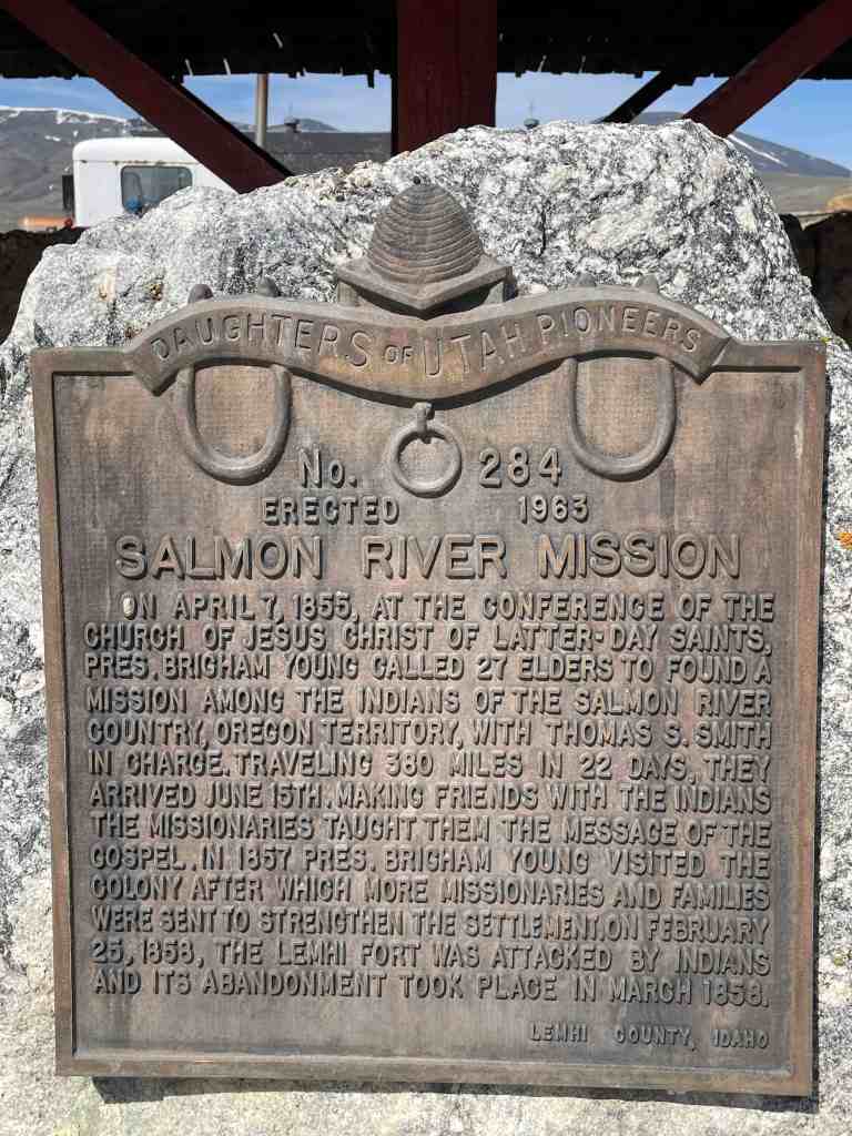
On April 7, 1855, at the conference of the Church of Jesus Christ of Latter-Day Saints, Pres. Brigham Young called 27 elders to found a mission among the Indians of the Salmon River Country, Oregon Territory, with Thomas S. Smith in charge. Traveling 380 miles in 22 days, they arrived June 15th. Making friends with the Indians the missionaries taught them the message of the gospel. In 1857, Pres. Brigham Young visited the colony after which more missionaries and families were sent to strengthen the settlement. On February 25, 1858, the Lemhi Fort was attacked by Indians and its abandonment took place in March 1858.
Daughters of Utah Pioneers historic marker #284, erected in 1963 and located on Lemhi Road north of Lemhi, Idaho.
Arriving at the headwaters of Lemhi River, a company of Latter-Day Saint men who had been called to establish a mission among the Indians proceeded approximately 30 miles downstream, selected a site for a fort and a tract of farming land, On June 18, 1855, they dug a ditch, turned the water over the land, and after ploughing about 8 acres, planted corn, turnips, peas, beams and potatoes. This was the first irrigation project in the Great Northwest.
Daughters of Utah Pioneers historic marker #285, erected in 1963 and located on Lemhi Road north of Lemhi, Idaho. Marker #284 is also located here.
The first house of worship erected in the Upper Snake River Valley, was located approximately five and three-fourths miles west, and one and three-fourths miles south of this marker. It was completed by members of the Egin Branch of the Cache Stake of the Church of Jesus Christ of Latter-day Saints, December 6, 1882, and destroyed by fire in February, 1886.
Also honoring the pioneers who came into this valley between 1879-1890.
This monument, formerly two blocks south, was moved here when the Tabernacle, built in 1916 by the Church of Jesus Christ of Latter-day Saints, was razed.
Daughters of Utah Pioneers historic marker #70, erected May 23, 1941 and located at 220 South Bridge Street in St Anthony, Idaho.
In 1888 the first settlers of the Coltman Ward cleared the sage brush, dug canals and ditches, and built humble homes. At first it was a part of what was called Poverty Flat, later named Grant Ward. In 1896 Grant was divided and this, the south part, was named Coltman. Their one room building was used for church, school, recreation and community business meetings. Ebenhardt Bauer was the first Latter-day Saint presiding elder and also the first bishop.
Daughters of Utah Pioneers historic marker #182, erected in 1953 and located at 12448 N 5th E in Ucon, Idaho.
Under the Homestead Act of 1880, John Lingren acquired this land, cleared the sagebrush, raised vegetables and dairy products, started a nursery, planted hundred of fruit, evergreen, shade and ornamental trees. It became Idaho Falls’ first amusement park when in 1904-5 a picnic area, baseball diamond, dance pavilion, boating pond and swimming pool were added. In 1920 Idaho Falls purchased the park and later the old buildings were demolished, leaving only a log structure which had been used for school, church and tourist accommodations.
Daughters of Utah Pioneers historic marker #286, erected in 1963 and located at 530 West Elva Street in Idaho Falls, Idaho.
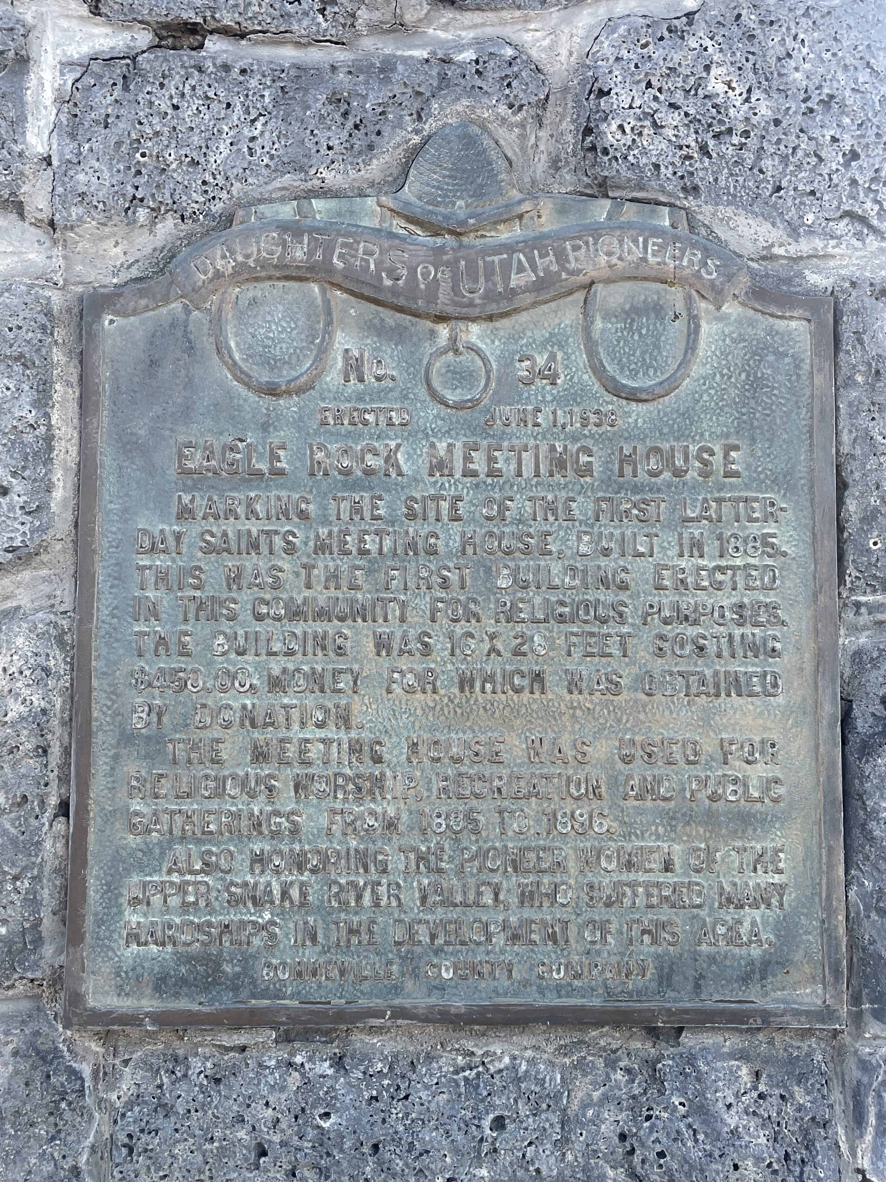
Marking the site of the first Latter-Day Saints meeting house, built in 1885. This was the first building erected in this community for religious purposes. The building was 16 X 28 feet costing $450.00, money for which was obtained by donation.
The meeting house was used for religious worship, recreation and public gatherings from 1885 to 1896.
Also honoring the pioneer women of the Upper Snake River Valley, who suffered many hardships in the development of this area.
Daughters of Utah Pioneers historic marker #39, erected June 1, 1938 and located along the Idaho Falls Greenbelt Trail near the intersection of Riverside Drive, Memorial Drive and E Street in Idaho Falls, Idaho.
The fertile soil and abundance of water in this valley lured pioneer settlers. With small slip scrapers, hand plows, picks and shovels, they cleared sagebrush, built log homes, made canals, ditches and dams to put water on the land. One of the first canals was built in 1879-1880. Rock and brush dams were built to divert water into headgates. Men lost their lives in this work. Later canals were enlarged and better dams built. The largest dam, known as the “Great Feeder”, completed June 22, 1895, diverts water from South Fork into a network of canals. Through consolidation of canal systems, 700,000 acres of irrigated land with 100 canals, known as the Upper Portion of District No.36, are using 4,150,000 acre feet of water from the river and its tributaries each irrigation season. Here the dream of reclaimed desert has been brought to full fruition. This is the legacy left by those pioneers to present and future generations.
Daughters of Utah Pioneers historic marker #228, erected in 1956 and located along the Idaho Falls Greenbelt Trail near the intersection of Riverside Drive, Memorial Drive and E Street in Idaho Falls, Idaho.
The Pass of the Standing Rock was held sacred by the ancient ones of the Shoshone and other Native American Tribes long before John C. Fremont’s exploratory party came to Weston Canyon on August 29, 1843. Fremont’s surveyors spent the entire day exploring, measuring, and illustrating this location that Fremont later named, The Pass of the Standing Rock. Illustrations of Standing Rock were published in Fremont’s The Exploring Expedition to the Rocky Mountains, depicting the Great Basin of the West.
The giant sentinel rock fell from the cliffs above, landing perpendicular near the middle of the valley. The elevation at the base of Standing Rock is 5,381 feet. The rock stands nearly 100 feet tall, is 75 feet wide, and weights several thousand tons. Nearby, naked blue limestone crags spire skyward into pinnacles that dominate ridges the entire length of Weston County.
Weston pioneer settlers arrived from Richmond, Utah, on April 15, 186?, temporarily housing their families in wagon boxes, tents and dugouts. Others dwelt in two large canyon caves. They cut logs for cabins and cedar posts for fencing. Settlers harnessed the canyon steams and springs to construct the original Pioneer Dam, located just below Castle Rock. The buffalo, elk, deer and antelope were almost extinct because of trappers who had exploited the furs of the valley. Fish and small game provided sustenance until crops could be raised. The pioneers delighted in naming the rock formations throughout the pass: Castle Rock, Vision Rock, Johnny Jump Off, Peek a Boo, Three Bars of Soap, Balancing Rock, Spirit Rock, Eagle Rock, East Gate and West Gate.
Weston is the second oldest permanent white settlement in Idaho. Bishop Peter Maughan directed construction of the first meetinghouse in 1869. Brigham Young, church president, traveled from Malad, Idaho, to Weston by coach on June 8 and 9; he delighted in the archeology of the canyon. Young’s church sermon encouraged the agricultural efforts of Weston, especially the farming of wheat.
The harsh winter snows and spring runoff often closed the pass. In 1960, the road was paved, allowing year-round access to one of the archaeological jewels of Idaho. This pass has been a place of rest, reflection, reverence, and renewal. It represents outstanding rock, flora, and forest. It is a treasured landmark in the history of the early pioneers.
The above text is from the historic marker placed by the Daughters of Utah Pioneers, see others on this page. The marker number listed on the plaque is #553 but this marker in Deseret, Utah also had that number and the DUP has called this “Pass of the Standing Rock” marker #552 in their published book.
The photos below were submitted by Marshall Hurst: