
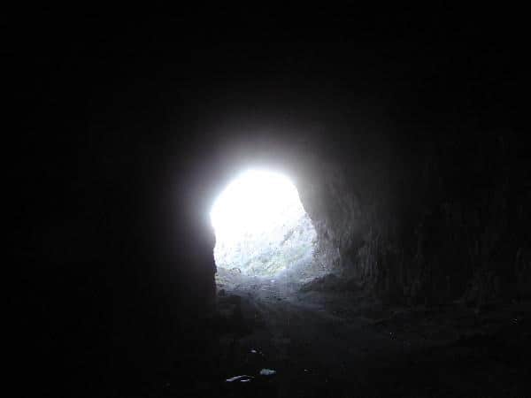
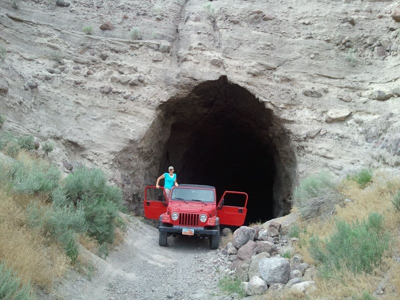
There’s an abandoned train tunnel off the Elberta Slant Road where the old railroad grade to Eureka was, it’s a fun place to go drive a Jeep through, I’ve taken many people there just for the fun of driving through a train tunnel.


24 Wednesday Aug 2016
Posted in Uncategorized
There’s an abandoned train tunnel off the Elberta Slant Road where the old railroad grade to Eureka was, it’s a fun place to go drive a Jeep through, I’ve taken many people there just for the fun of driving through a train tunnel.
27 Wednesday Jul 2016
Posted in Uncategorized
Tags
Twelve Mile Pass is a fun area to explore West of Utah Lake. There are a lot of mines, caves, snakes, lizards and dirt roads.
25 Monday Jan 2016
Posted in Uncategorized
Tags
Elberta, Mosida, Saratoga Springs, utah, utah county, Utah Lake


Another “map dot” and “used-to-be-town” in Utah. This is whree Soldiers Pass meets Redwood Road (Highway 68) near Mosida on the West side of Utah Lake.
19 Saturday Dec 2015
Posted in Uncategorized
Tags
Out benchmark hunting, Benchmark: LO0794 ” 5 12 A ” was a fun one. It’s cool to see these last over 100 years, even if this one wasn’t in great shape. This was placed June 4th, 1912.
| 01/01/1948 by USGS (GOOD) |
| DESCRIBED BY US GEOLOGICAL SURVEY 1948 LOCATED ON LOW GREASEWOOD-COVERED RIDGE. TO REACH FROM ELBERTA, DRIVE N. ON RD. FOR ABOUT 9.0 MI. TO RD. FORKS, TURN RIGHT E. AND DRIVE TO ABANDONED HOUSE AND CORRAL TURN N. AND FOLLOW 1.0 MI. TO GATE IN FENCE CORNER, CONTINUE ABOUT 0.4 MI. TO DIM RD. BEARING NE. FOLLOW ABOUT 1000 FT. STATION IS ABOUT 600 FT. S. ON SAGE BRUSH RAISED GROUND. STATION MARK – USBR TRIANGULATION CONCRETE POST INSCRIBED —USRS NO JUNE 4 1912— REFERENCE MARKS – NONE. |
Photos I took on 11/11/2007


Photos I took 10/11/2015


19 Saturday Dec 2015
Posted in Uncategorized
Soldiers Pass goes over the South end of Lake Mountain from Highway 68 (Redwood Road, Mosida) to the Eagle Mountain area.


26 Monday Oct 2015
Posted in Uncategorized
Tags
Chimney Rock, Elberta, Little Moab, Mosida, utah, utah county, West Desert
Chimney Rock was one of my favorite areas to go explore as a kid, it is very close to Little Moab and Nutty Putty Cave (which is closed now.)

10 Monday Aug 2015
Posted in Uncategorized
Tags


Coyote Pass, just west of Mosida, Utah
19 Tuesday Nov 2013
Posted in Uncategorized
The Goshen Valley is a 17-milelong valley located in southern Utah County.
A southern arm (Goshen Bay), of Utah Lake bisects the valley, with western shore valley areas extending north to Mosida, at the south end of Lake Mountain.
Adjacent just south of West Mountain is another mountain, Warm Springs Mountain, its western flank is the site of the abandoned mining operation, the Tintic Standard Reduction Mill, (Known as Harold, Utah) and adjacent west is Warm Springs.
18 Monday Nov 2013
Posted in Uncategorized
Tags
Gorder, Knolls, Mosida, Pelican Point, utah, utah county, Utah Lake

A topographic feature used by fishermen and sportsmen on Utah Lake, “The Knolls” were used a navigational beacon.


12 Tuesday Nov 2013
Posted in Uncategorized
Tags

Mosida Utah

Bateman’s Mosida Farms
Mosida is near the south-west shore of Utah Lake, eleven miles north of Elberta. on December 5th, 1908, R.F. Morrison, Joseph A Simpson, and J.E. Davis purchased 6,880 acres of land to establish a new community. Within four to five years a hotel, schoolhouse, post office, and general store were operating. In 1915 the town was hopelessly in debt and by 1924 it was a ghost town. The community name was coined from the first two letters of the three promoters, Morrison, Simpson, and Davis.
In 1911 a telephone line from Lehi was completed and 20 new homes were built. The following year, a 25-room hotel was constructed, as well as a schoolhouse, a post office, and a general store. Mosida boasted a population of almost 600. Mosida was growing, but in 1914 something unexpected happened — the water level in Utah Lake was going down, and by the summer of 1915 the lake had receded a record setting three-eighths of a mile, leaving the pump house useless. The crops soon died. Debts went unpaid and people started leaving.(*)

Mosida Lodge and Wildlife Refuge

Mosida Hotel

Remains of the hotel
Mosida has a church replica handcart trek (my parents are in the stake that runs it), they allow people to reenact the pioneers coming across Wyoming trying to get to Utah. (visit link)
Here’s a cool website talking about Mosida.
Another good one, http://www.waterhistory.org/histories/mosida/mosida.pdf
On 3/19/16 I stopped by with my family and the property owner and took some pictures that can be seen here: