• About JacobBarlow.com
  • Cemeteries in Utah
  • D.U.P. Markers
  • Doors
  • Exploring Utah Email List
  • External and Referral Links
  • Geocaching
  • Historic Marker Map
  • Movie/TV Show Filming Locations
  • Oldest in Utah
  • Other Travels
  • Photos Then and Now
  • S.U.P. Markers
  • U.P.T.L.A. Markers
  • Utah Cities and Places.
  • Utah Homes for Sale
  • Utah Treasure Hunt

JacobBarlow.com

~ Exploring with Jacob Barlow

JacobBarlow.com

Tag Archives: San Mateo County

Town of Searsville

25 Friday Dec 2020

Posted by Jacob Barlow in Uncategorized

≈ Leave a comment

Tags

Benchmarks, California, California Historical Landmarks, Historic Markers, San Mateo County, Woodside

Town of Searsville

Here stood the lumbermen’s village of Searsville whose first settler, John Sears, came in 1854. Across the road westerly from this monument stood a hotel. The school, store, blacksmith shop, and dwellings were to the southeast, some on the site of the present lake and others overlooking it. Buildings were removed in 1891, as water rose behind the new dam.

State Registered Landmark No. 474 (see others on this page)

Plaque placed by the Board of Supervisors of San Mateo County in cooperation with the San Mateo County Historical Association.
Dedicated June 8, 1952

Location: N 37.40264 W 122.24520
(Portola Rd and Sand Hill Rd in Woodside, CA)

Beginning of the Internet Age

18 Monday May 2020

Posted by Jacob Barlow in Uncategorized

≈ Leave a comment

Tags

California, Historic Markers, Internet, Portola Valley, San Mateo County

On August 27, 1976, scientists from SRI International celebrated the successful completion of tests by sending an electronic message from a computer set up at a picnic table behind the Alpine Inn. The message was sent via a radio network to SRI and on through a second network, the ARPANET, to Boston. This event marked the beginning of the Internet Age.

Related Posts:

  • Casa De Tableta (history of this location)

Casa De Tableta

15 Wednesday Apr 2020

Posted by Jacob Barlow in Uncategorized

≈ Leave a comment

Tags

California, California Historical Landmarks, Historic Markers, Portola Valley, San Mateo County

Casa De Tableta

California Registered Historical Landmark # 825

This structure, built by Felix Buelna in the 1850’s, served as a gambling retreat and meeting place for Mexican-Californios. It was strategically located on the earliest trail used both by Rancheros and American settlers crossing the peninsula to the coast and served this remote area. Acquired by an American in 1868, it has continued to serve under various names as a roadhouse and saloon.

Plaque placed by the State Department of Parks and Recreation in cooperation with the town of Portola Valley, May 24, 1969.

Related Posts:

  • Beginning of the Internet Age
  • California Historical Landmarks

Portolá Journey’s End

12 Friday Oct 2018

Posted by Jacob Barlow in Uncategorized

≈ Leave a comment

Tags

California, California Historical Landmarks, Historic Markers, Menlo Park, San Mateo County

2018-09-28 12.31.23

Portolá Journey’s End

November 6-10, 1769
Near “El Palo Alto”, the tall tree, the Portolá expedition of 63 men and 200 horses and mules camped. They had traveled from San Diego in search of Monterey but discovered instead the Bay of San Francisco. Finding the bay too large to go around, and deciding that Monterey had been by-passed, they ended the search and returned to San Diego.

California Registered Historical Landmark No. 2
Plaque placed by State Department of Parks and Recreation in cooperation with the Portolá Expedition Bicentennial Foundation, November 8, 1968.

This is California Historical Landmarks #2

2018-09-28 12.31.29

2018-09-28 12.31.34

First Camp After Discovery of San Francisco Bay

14 Tuesday Aug 2018

Posted by Jacob Barlow in Uncategorized

≈ 1 Comment

Tags

California, Historic Markers, San Mateo County

1408-2018-115549564466127637

First Camp After Discovery of San Francisco Bay

On November 4, 1769, the expedition of Captain Gaspar de Portola, after crossing Sweeny Ridge, beheld the Bay of San Francisco for the first time. That night they camped at a small lagoon, now covered by San Andreas Lake. Finding the bay too large to go around and thinking they had by-passed Monterey Bay, the expedition camped here again on November 12, 1769 on their return to San Diego.

First made a State Registered Historical Landmark No.27, June 15, 1932, this site was rededicated as a U.S.A. Bicentennial Project of San Andreas Lake Chapter, Daughters of the American Revolution and the City of Millbrae, California on November 6, 1976

Location granted by the State of California

Monument Base of Serpentine Rock, Official State Rock of California, Furnished by the San Francisco Water Department.

Mrs. Alfred P. Hall (Ethel Leota Bernritter) Organizing member of San Andreas Lake Chapter NSDAR, of Millbrae, California, after nearly 10 years of research, was successful in restoring and rededicating California Registered Historic Landmark No.27 N. Vannucci, W. Monlux, N. Campagna, O. Baswell, P. Perry

1408-2018-111649585623660631

Union Cemetery

18 Wednesday Oct 2017

Posted by Jacob Barlow in Uncategorized

≈ 4 Comments

Tags

California, Cemeteries, historic, Historic Markers, NRHP, Redwood City, San Mateo County, Union, Union Cemeteries

2017-10-02 13.09.14

Union Cemetery’s name reflects the controversy that erupted in the Civil War, three years after the cemetery’s beginnings in 1859. Pro- and anti- slavery feelings ran high in California, and the founders of the cemetery strongly opposed the secessionist sentiment that threatened the nation’s unity. Because of a controversy over the cemetery’s ownership, the state enacted its first cemetery legislation, although its provisions did not affect Union Cemetery. The law of 1859 allowed for the incorporation of rural burial grounds. The state of California owned Union Cemetery from 1859 until 1962 when it was deeded to Redwood City.

See also:

  • California Historical Landmark #816.
  • Solari Windmill

2017-10-02 13.09.19

2017-10-02 13.09.28
2017-10-02 13.09.34
2017-10-02 13.09.41
2017-10-02 13.09.44
2017-10-02 13.09.58

2017-10-02 13.10.38

2017-10-02 13.10.07
2017-10-02 13.10.51
2017-10-02 13.11.45
2017-10-02 13.11.53
2017-10-02 13.14.43

2017-10-02 13.15.01

2017-10-02 13.16.09
2017-10-02 13.16.44
2017-10-02 13.17.18
2017-10-02 13.17.23
2017-10-02 13.17.50

2017-10-02 13.15.49

2017-10-02 13.18.16
2017-10-02 13.19.00
2017-10-02 13.19.28
2017-10-02 13.20.30
2017-10-02 13.20.35

2017-10-02 13.20.47

2017-10-02 13.21.02


Solari Windmill

18 Wednesday Oct 2017

Posted by Jacob Barlow in Uncategorized

≈ 3 Comments

Tags

California, historic, Historic Buildings, Redwood City, San Mateo County, Windmills

2017-10-02 13.13.42

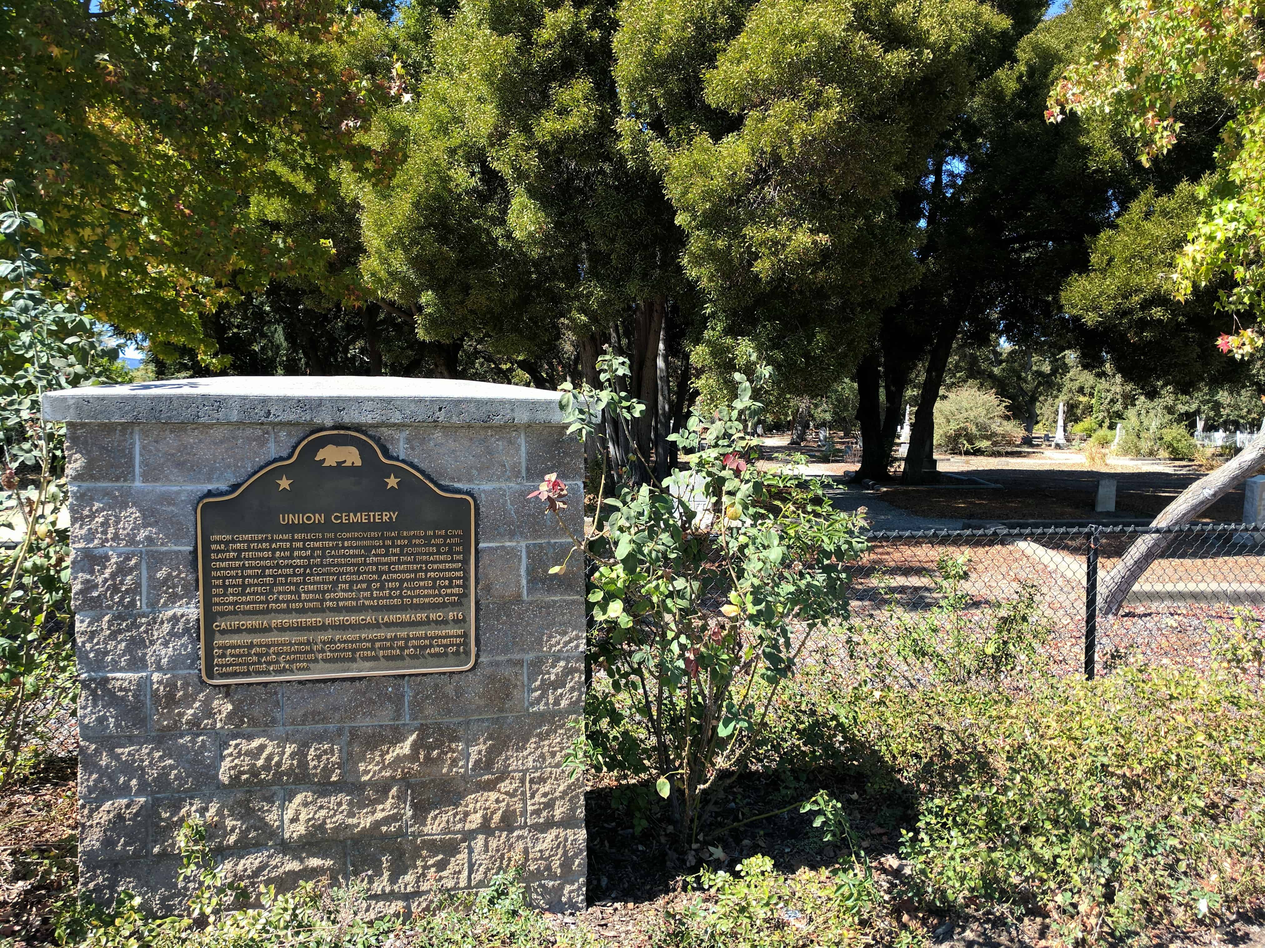
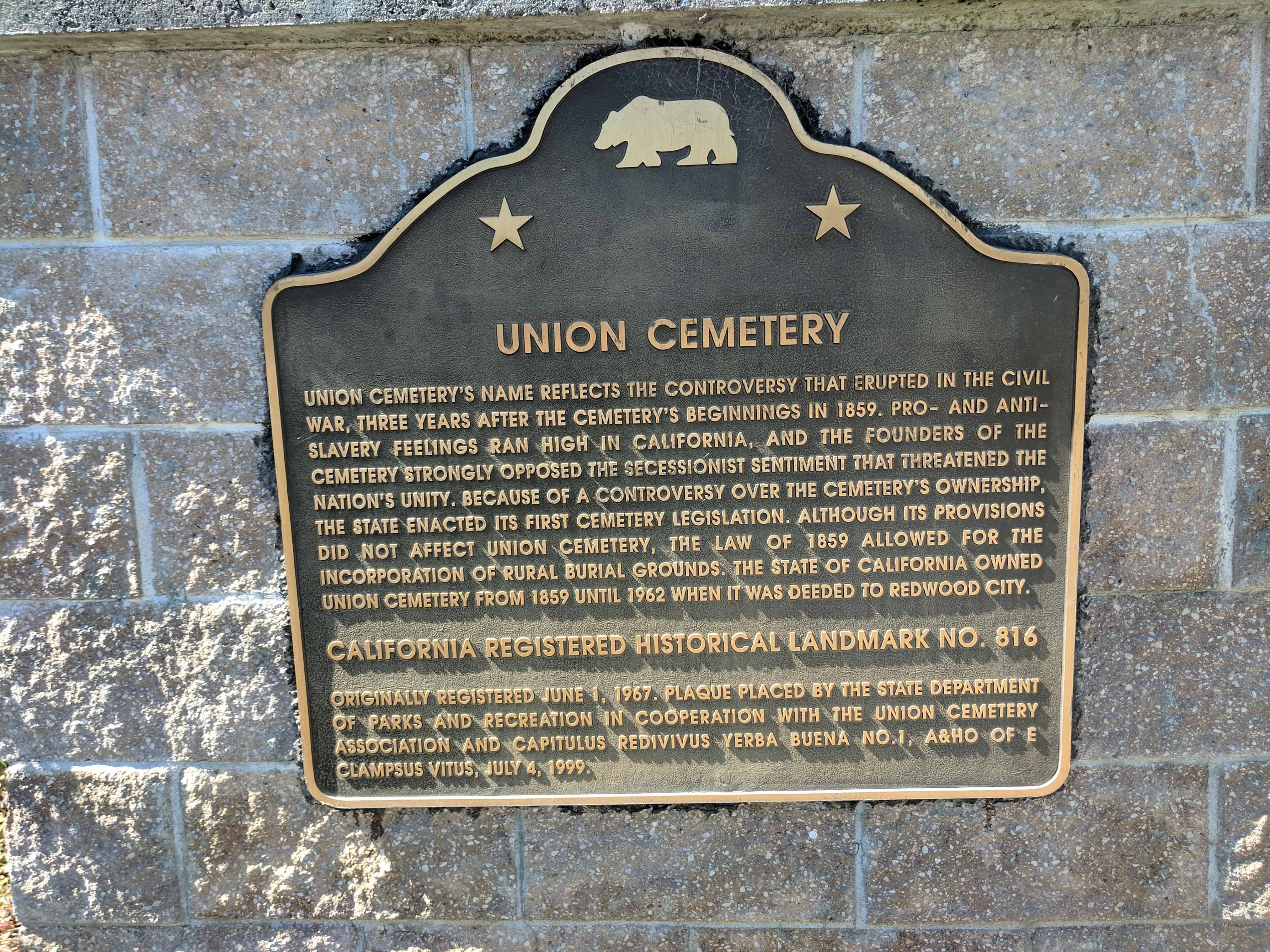
Located at the Historic Union Cemetery.  The Solari Family Windmill was built in the 1880’s on the Solari farm, located at Whipple Avenue and Old County Road in Redwood City.

It was move in the 1930’s to the new family farm located on Manzanita Street near Middlefield Road and the railroad tracks, two blocks east of its present day location. It was again moved in 1990 as the property had been sold. To save the windmill from being demolished, it was disassembled and reconstructed on the grounds of the Garfield School and later disassembled again and stored at a Redwood City maintenance yard.

In May 2007, through the efforts of the City of Redwood City, Redwood City Parks and Recreation Department, and Redwood Parlor No. 66 Native Sons of the Golden West, the windmill was reassembled and refurbished at its present location in Union Cemetery, Redwood City.

The Solari Family Windmill is the last known functional windmill of its kind on the Peninsula.

George Solari, the last owner of the windmill was born in Redwood City on January 14, 1904 and lived on the family farms his entire life. He was a member of the Native Sons of the Golden West, Redwood Parlor No. 66, being initiated on July 17, 1924. He as an active member for 65 years, serving as Parlor President in 1945. George Solari passed on the Grand Parlor on High on March 29, 1998.

2017-10-02 13.14.04

2017-10-02 13.14.24

This reconstructed windmill was originally built in the 1890’s on the George Solari family farm which was located near Whipple Avenue and Old County Road in Redwood City. When the area was subdivided in the 1930’s, the windmill was moved to the new family farm located near Woodside Road and Middlefield Road.

In 1990, the windmill was relocated to Garfield School as part of a new agricultural program. In order to save the windmill from demolition, Jean Cloud and Jeri Joseph-Hover encouraged the city of Redwood City to relocate the windmill to the city’s maintenance yard in June 2000. In 2006, the Union Cemetery site was approved as the new home of the Solari Windmill. The final phase of reconstruction was started in early 2007. Redwood Parlor #66 of the Native Sons of the Golden West refurbished the water tank house which was moved to the Union Cemetery site on May 18, 2007. This project was completed with the support of a number of local volunteers and community donations.

2017-10-02 13.14.17

2017-10-02 13.14.13

Palm Park

18 Wednesday Oct 2017

Posted by Jacob Barlow in Uncategorized

≈ 1 Comment

Tags

California, Parks, Redwood City, San Mateo County

2017-10-02 13.04.38

Palm Park in Redwood City, CA.

2017-10-02 13.04.50

2017-10-02 13.05.05

2017-10-02 13.04.55

Redwood City, California

18 Wednesday Oct 2017

Posted by Jacob Barlow in Uncategorized

≈ 4 Comments

Tags

California, Redwood City, San Mateo County

  • 2017-10-02 13.04.55

Redwood City incorporated in 1867, the first city to do so in San Mateo, and it has been the county seat since the county was formed in 1856. The land had been part of the Rancho de las Pulgas granted to the Arguello family in 1835 by the Mexican government. Their control was challenged after the Mexican-American War when California became part of the United States. The family lawyer, Simon M. Mezes, in 1854 defended the claim somewhat successfully and was allowed to buy the part of the estate that is now Redwood City. Mezes sold some of the land to people already squatting on it along the banks of Redwood Creek and named the settlement, Mezesville. Though the city did not keep that name, Mezes Park still exists on land Mezes had given for open space.

Some Redwood City Related Posts:

  • Palm Park
  • Solari Windmill
  • Union Cemetery
  •  
  •  Redwood City posts sorted by address

Follow Jacob

Follow Jacob

Social and Other Links

BarlowLinks.com

Blog Stats

  • 880,334 hits

Recent Posts

  • 47 N Main St
  • Duet
  • Water Play
  • Victory Memorial
  • 3435 S West Temple

Archives


Loading Comments...