This ranch on the west side of Highway 89 in Birdseye, Utah is talked about a lot for formerly being owned by country music star Willie Nelson.
Randal B. Thatcher has a cool article in the Sanpete Messenger: I happened to ask my cowboy neighbor, recently, what he knew about the history of that fabled “WN” ranch, and he promptly introduced me to his longtime friend, Kal, a resident of Mt. Pleasant, who proceeded to give me the following firsthand account, which I paraphrase:
Kal had once been a horse trainer and occasional stunt double for the actor Robert Redford, who introduced him to a friend who was looking to buy some horses. Kal said this would-be buyer did not have the look of a traditional horseman, with his scruffy, white beard, and his dingy, red bandanna tied around a head of long, strawberry-blonde hair.
The buyer turned out to be none other than the famous singer, Willie Nelson.
They instantly hit it off, and before he knew it, Kal was looking for property for the famous singer somewhere in the Central Utah area, where Willie could keep his newly acquired horses and bring friends to visit.
Kal crisscrossed the state from St. George to Spanish Fork looking at over a dozen available properties before finally settling on the 95-acre ranch in Birdseye.
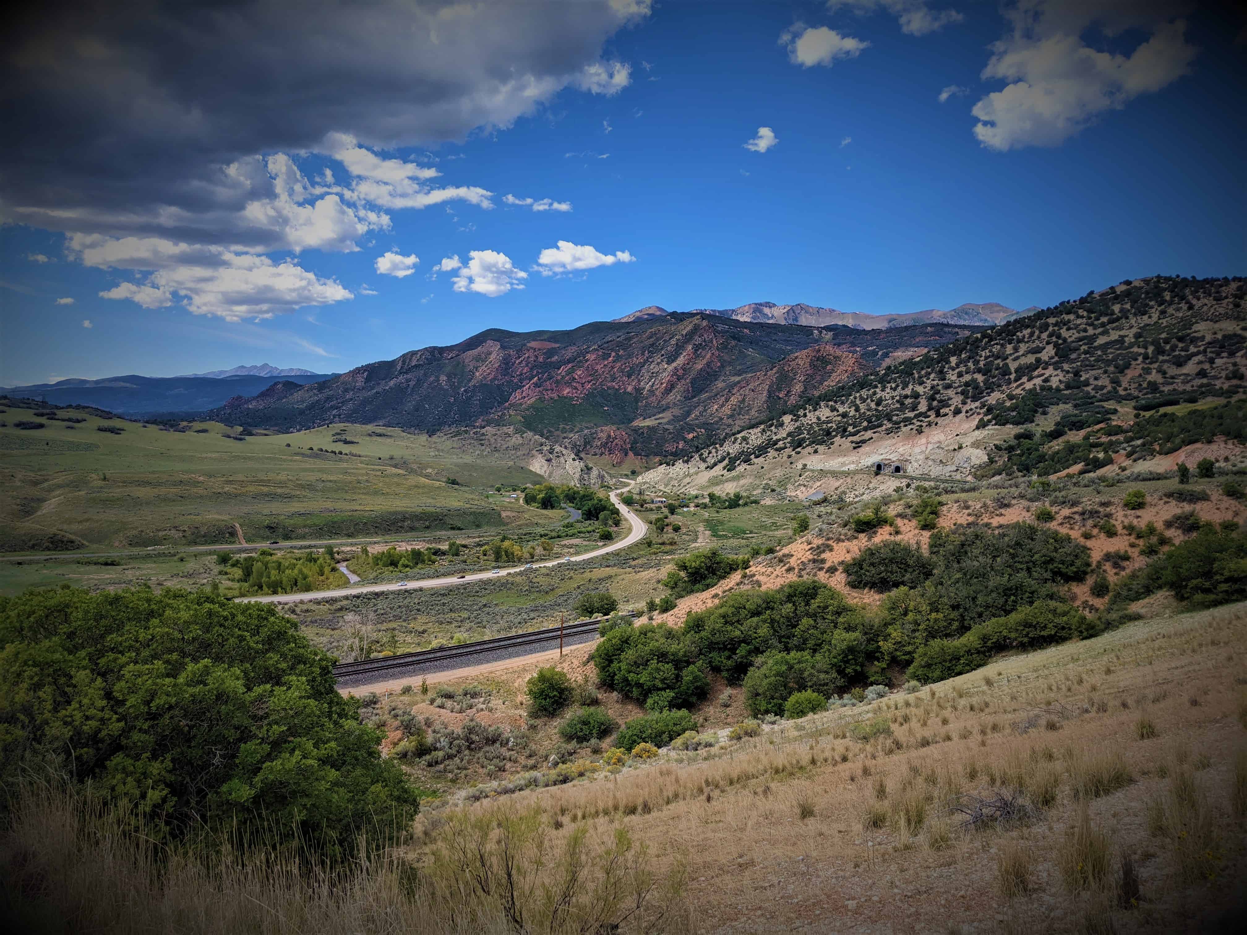
Looking east to the red ledges you can see the quarry, originally operated by the Mormon Church and others from the 1880’s to the 1940’s as the Nebo Rock Works, Thistle Rock Works and Birdseye Marble quarry.
The stone polishes to a high degree and is prized by jewelers and builders. Stone from the quarry is in the Utah State Capitol, the Mormon Chapel in Washington, D.C., and the Lincoln Memorial, and other state and federal buildings.
Thanks to The Road Commission The Manti-La Sal National Forest The people of Birdseye Erected by the sons of the Utah Pioneers Palmyra Chapter 1990
See other historic markers in the series on this page for SUP Markers.
Indianola is in Sanpete County, Utah. It is located just off Highway 89 between Birdseye and Fairview, near Hideaway Valley. It is the former site of an Indian village.
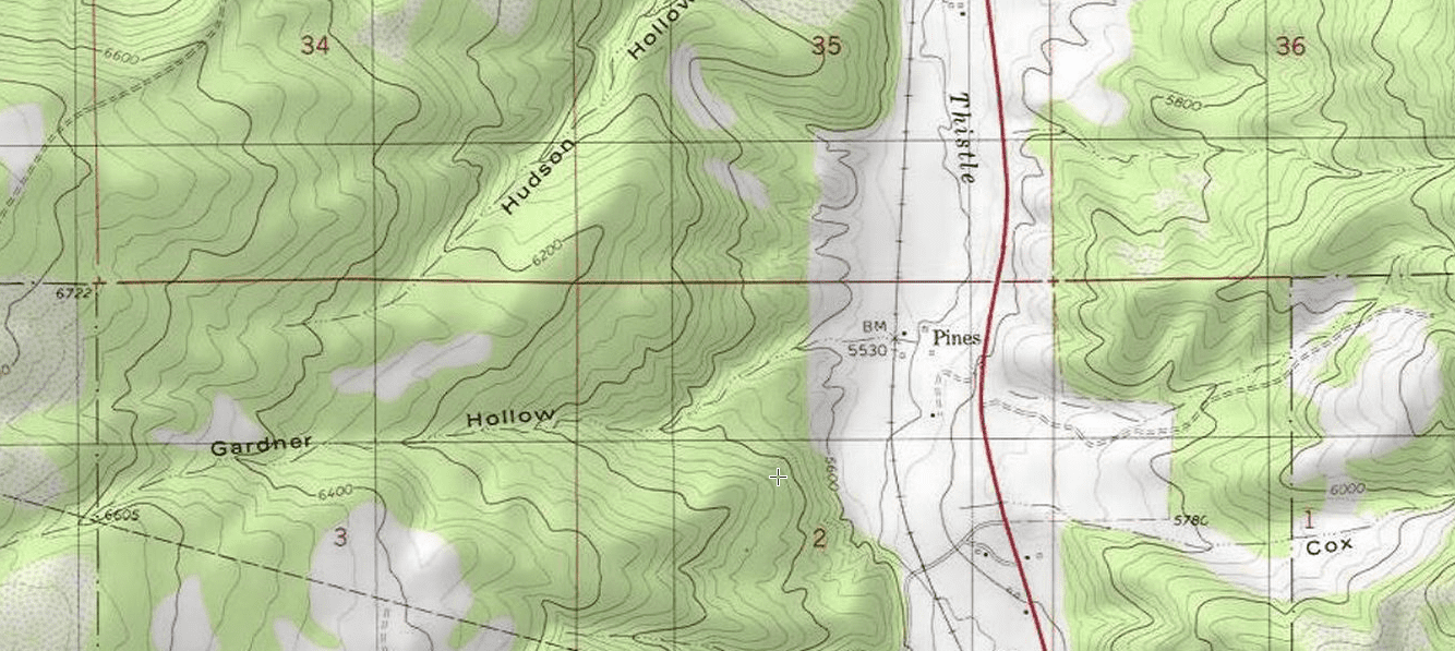
Pines shows up on my maps as a small placename, I haven’t been in to the ranch but I drive by it often and would love to check it out and learn some history of the area.
In the spring of 1865 John Given with his wife Eliza and their four children, John Jr., Mary, Anna, and Martha settled in the meadow land about 110 feet west of here. They built a cabin and willow shanty. Charles Brown and Charles W. Leah were helping them plow and plant crops. Early in the morning of May 26th they were attacked by a band of Indians. Brown and Leah escaped and ran six miles for help, which came too late. The entire Given family was massacred and their cattle and household furnishings taken. The murdered people were buried in Fairview.
Birdseye is at the junction of Thistle Creek and Bennie Creek, seven miles south southwest of Thistle Junction. It was settled in 1885 and named Summit Basin, then in 1897 the name was changed to Clinton. Later, the town was named Birdseye for the nearby birdseye marble quarries in the Indianola area to the southeast.(*)
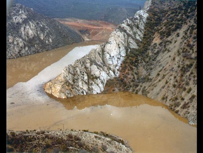
In April, 1983 a massive landslide dammed the Spanish Fork River. Residents evacuated as the valley filled with water backed up, flooding the town and destroying the town. It was the first presidentially declared disaster area in Utah.
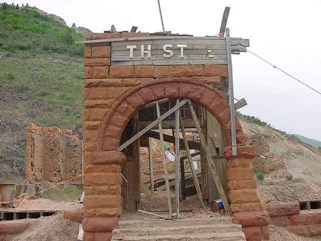
There are a few structures remaining, you can see a few in this video.
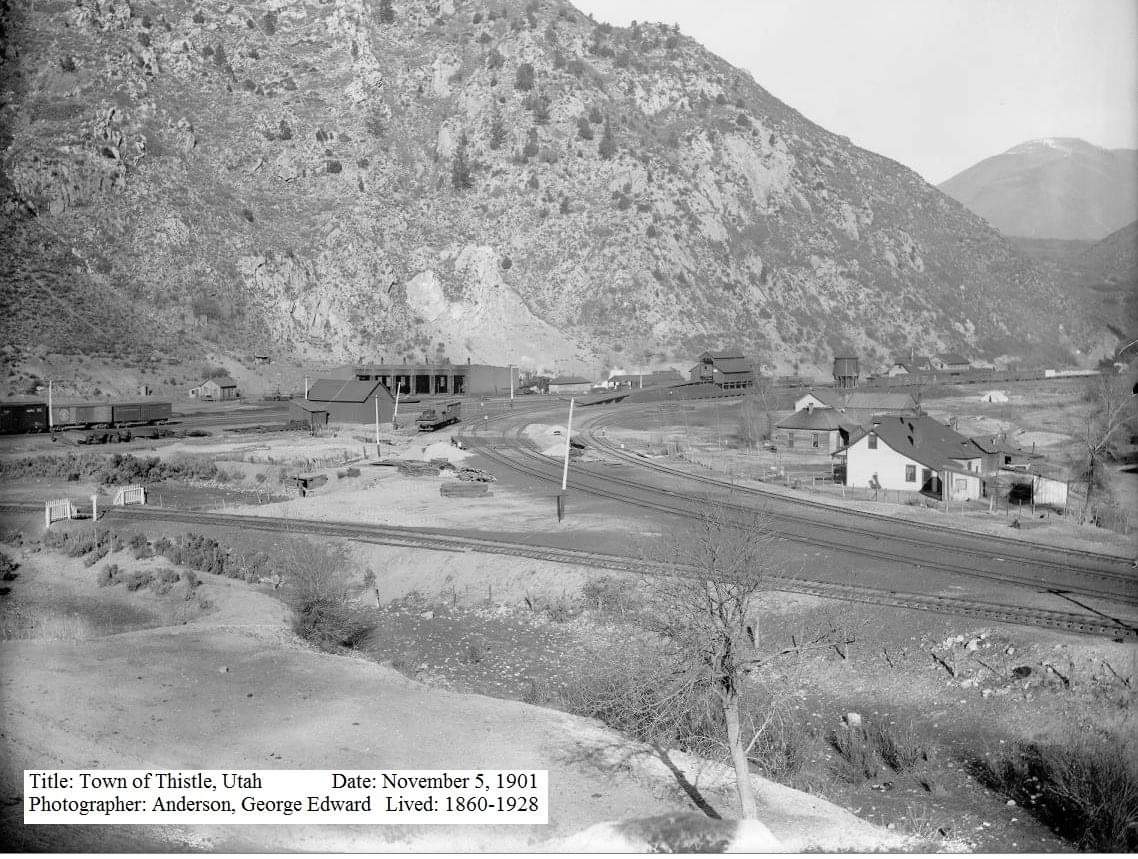
In 1983 the town of Thistle, Utah, known to many highway travelers as the small community where both the Spanish Fork River and nearby U.S. highways branch, was eliminated by the most costly landslide on record in the United States.
Thistle was located at the triple junction of transportation systems leading south to Sanpete County, east to the coal counties of Carbon and Emery and points beyond, and northwest to the Wasatch Front and Salt Lake City. Two major highways converged at Thistle (U.S. Highways 89 and 6). Until the landslide, two rail lines also converged at Thistle–the main line of the Denver and Rio Grande Western Railroad (D&RGW) joining Denver and Salt Lake City, and a branch line to Marysvale.
Ironically, the main line of the D&RGW railway from Denver to Salt Lake City follows the Soldier Creek and Spanish Fork drainages because of, rather than in spite of, landslides. Few corridors through the Rocky Mountains accommodate the gentle gradients required by railroads. Less stable landforms susceptible to landslides have eroded and formed the gentler terrain that allows modern rail passage. The advantages of this route had long been known. Undoubtedly the local Native Americans who guided the Spanish explorers traveled this route. Later trappers and pioneers used this natural corridor for their trade and transportation needs. The name “Spanish Fork” refers to the early exploration of the area by the Spanish, specifically Dominguez and Escalante in 1776 as they sought a trading route from Mexico to California. Soldier Creek is named for the route taken by federal troops as they moved through the area in the mid-1800s.
Thistle became an important junction on the railroad with the 1890 completion of a branch line south through Sanpete Valley. When the Utah Railway Company began to construct its own line in 1912, a second set of tracks up Spanish Fork Canyon to Helper, the D&RGW contracted to maintain the tracks for joint use and to maintain the Marysvale line. Ninety years later, because the Thistle landslide buried the exact junction and joint tracks, the two companies fought out legal responsibilities and insurance claims in the courts.
The town of Thistle expanded and contracted with the fortunes of the railroad. The town saw its heyday in the early 1900s. Six hundred residents lived in Thistle in 1917. Changing economics and technologies reduced the need for an active rail town with its large depot, water and coal supplies, roundhouse, and supporting stores, post office, schoolhouses, and saloon. The depot was torn down in 1972. Shops closed, and even the post office closed in 1974. A few families stayed; others moved in. In March 1983, fifty residents in a dozen houses claimed the town of Thistle as their home.
For a century, the D&RGW competed with the Union Pacific for traffic from Denver to Salt Lake City. Mineral, energy fuels, and manufacturing products dominated the railroad’s freight and revenues. Eastern Utah mines generated almost half of the freight tonnages. During the 1950s the railroad branch from the Sanpete-Sevier region carried manufactured wallboard, as well as mine and agricultural products. However, by 1983 trains to Marysvale were infrequent and the Thistle landslide provided the coup de grace for the D&RGW to obtain permission to close the unprofitable line. The landslide prematurely shut down the D&RGW Zephyr passenger service and delayed the start of Amtrack’s “California Zephyr” service on the D&RGW main line.
Storms heralding the 1982 to 1986 wet cycle kicked off the wettest month ever recorded at the Salt Lake City International Airport in September 1982, and saturated the ground before the winter snows. The winter was neither exceptionally wet nor cold. However, snows and cold nights continued late into April and May 1983, and resulted in an unusually late and sudden snowmelt when temperatures did warm up. May snowpacks of northern Utah averaged two to three times their normal. Utah’s landslide problems correlate with precipitation and snowmelt. Two large landslides in the early spring alerted geologic experts to the situation. The National Weather Service briefed local and national officials about the unusual conditions. Yet even with the geologic and climatic indicators, the events of April, May, and June caught the state by surprise.
Starting in January, the D&RGW watched the Thistle area as well as several other landslide-prone areas near Soldier Summit. Their geotechnical experts visited the area on April 12. Days later, when the Thistle landslide began to move visibly, no one recognized it as a major hazard. The railroad tracks went out of alignment on Wednesday, 13 April. The highway became bumpy, fractured, and became impassible on Friday, 15 April. The streambed and deposits on the canyon floor rose approximately one foot an hour as a huge tongue of earth piled up against the bedrock buttress of Billies Mountain, filled the canyon, and dammed the river. The waters of the Spanish Fork River rapidly created Thistle Lake upstream of the landslide dam.
The railroad company and the Utah Department of Transportation (UDOT) initially tried to keep the railroad tracks, highway, and river open. Sunday, 17 April the landslide defeated efforts to cut down through the rising toe of the landslide and allow passage of the river water. Efforts to siphon waters rising behind the landslide dam also failed. Rising lake waters drowned the community of Thistle. That very day, the president of the D&RGW announced at Thistle that the railroad would tunnel a new railroad course through Billies Mountain. To be successful, the tunnel had to be above Thistle Lake’s eventual highest water line. Railroad experts in consultation with the state decided to form the landslide into a dam and to construct an overflow spillway tunnel to control the uppermost rise of the lake. Having calculated how fast an overflow tunnel could be constructed, and how fast the lake would rise, they began drilling. The state took charge of public safety priorities. Armies of workers and heavy equipment shaped the landslide dam while it moved by transferring 500,000 cubic yards of earth from the middle area of the landslide onto its toe. This also provided a platform from which to construct the tunnels. The state constructed a third tunnel to drain the impounded water. UDOT decided to relocate the highway over Billies Mountain. The Army Corps of Engineers constructed a pumping system to keep Thistle Lake from rising to dangerously high levels.
The impounded water rose at approximately the rate predicted and the D&RGW contractors completed the overflow tunnel system with two days to spare. Trains passed through the new tunnel on 4 July, eighty-one days after the initiation of the project and eleven days before the contracted completion date. The new tunnel provided a permanent bypass for the Spanish Fork River around the landslide. The relocated highway encountered difficult geotechnical problems. The highway opened at the end of the year but was often closed due to major rockfalls and slope stability problems.
The town of Thistle was destroyed. The Marysvale branch line of the railroad was never reopened, leaving a large area of central Utah without rail service. Thistle resulted in Utah’s first presidential disaster declaration and became the most costly landslide the United States had experienced. The Utah Business and Economic and Research Bureau reported the following dramatic impacts of the landslide. The D&RGW and Utah Railway embargoed all shipment that normally went through Thistle. The rerouting surcharge of $10 per ton virtually stopped coal shipments. Two trucking companies laid off workers, cancelled contracts, and even suspended operations. Most of the area’s coal mines laid off miners, cancelled contracts, and experienced shut downs. Some miners’ commutes suddenly exceeded 100 miles. Some coal haulage commutes trebled. Due to market conditions and the Thistle landslide, coal production dropped nearly 30 percent in 1983. Uranium producers paid substantially more for supplies in an already soft market. At least one oil company became non-competitive due to increased travel costs. Tourism in the area, particularly in-state tourism, sagged in response to negative publicity and difficult access. To the south, the blockage of route 89 and the Marysvale line hurt coal companies, turkey and feed operations, and gypsum, cement, and clay shipments.
The Thistle landslide caused total estimated capital losses of $48 million and revenue losses of $87 million, plus associated losses in tax revenues. Direct costs of Thistle tally over $200 million, including relocating the railroad at a cost of $45 million, relocating the highway at a cost of $75 million, and lost revenue to the railroad of $1 million per day (which totaled $80 million, including $19 million in charges that the D&RGW paid the Union Pacific to use their rail lines).
This is what it looked like in 2001 when I first explored it: