Tags

Bryce Canyon Airport
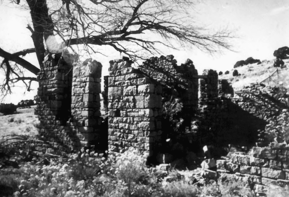
In the realm of airplane hangar construction and design, the Garfield County Airport Hangar is truly an oddity. The barn-like construction of native materials is a testimony to the ranching/agricultural background of the men who built it. Having no previous experience in designing or building an airplane hangar, they built in the style they knew with what they had. The soundness of this building bears witness to the excellence of craftsmanship and ingenuity of design.
The hangar is a tribute to the early days of air travel in the United States. In the mid-1930’s remote places such as Garfield County began to realize the benefits that could be derived from air services. Simultaneously, the U.S. Government realized that a network of airport facilities was a necessity. Thus, the W.P.A. and Garfield County worked together to further both local and national concerns.
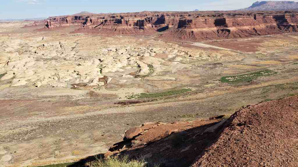
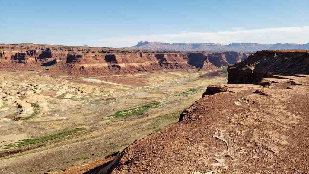
The airport reflects an attempt to encourage tourism by local officials and private individuals to Bryce Canyon which was declared a National Park in 1928. Xt also reflects the hope that air mail service could reach one of the most remote parts of the country. Finally the airport has served as a recreational, center for residents of Garfield County. Located roughly midway between Panguitch and Escalante, the airport hangar has been used for dances, ‘celebrations and other county activities since 1938. Although the structure is only 40 years old, it is recognized as an important local historical resource. .The hangar is undoubtedly one of only a few surviving hangars constructed of log.
Related:
- Bryce Airport: Lifeline in the Wilds (nearby historic markers)
- New Deal Funded Projects in Utah
Bryce Canyon Airport is located at 450 Airport Road in Bryce Canyon City, Utah and added to the National Register of Historic Places (#78002660) on October 19, 1978.

The Garfield County Airport began as a County W.P.A. project in 1936. Since the W.P.A. only provided partial funding, the county called for local men to donate their labor towards completion of the structure. Land for the airport was acquired from Ruby Syrett, J. Austin Cope, and others. Design of the structure and construction supervision was handled by the three county commissioners, Sam Pollock, Jennings Alien, and Walter Daly.
The logs used in construction of the hangar were cut as part of the C.C.C. project to eradicate the black beetle in Southern Utah. Infested trees were cut and sawed at the East Fork Sevier River sawmill by Garfield County men. They hauled the logs by teams of horses to the construction site.
A Garfield County News article of September 25, 1936 reported: “The project is being sponsored by Garfield County as a W.P.A. project and will cost about $38,669.00. About 320 acres of land has been set aside for the airport, which will consist of an 80-foot by 80-foot hangar of log construction with metal roof and concrete floor and warming-up apron.
Two runways, 5,000 feet long and 500 feet wide will be built. There will also be a waiting room with all the modern conveniences.”
The project was enthusiastically pursued especially after reports that Western Air Express would make the airport a regular stop between Los Angeles and Salt Lake City. The importance of the airport to tourism was recognized by Mormon church leader, George Albert Smith in a letter to County Commissioner, Walter B. Daley:
“I notice an article in one of the daily papers referring to your attitude toward the establishment of an airport in your section of the country.
Being airminded and believing that an airport near Bryce Canyon would be of great advantage to your people in that it would advertise the scenery of your section of the world and induce many people, sane of whom are welcome to investigate down there. I feel that it would be an excellent investment if it doesn’t cost too much.” (Garfield County News, February 28, 1936, p.1)
Despite some delays because of a lack of workers and administrative technicalities, the project progressed and by the spring of 1938, was sufficiently complete to schedule the first landing during Air Mail Week. On May 12, 1938 the Garfield County News announced that the following Thursday, May 19th, T. E. Garn, Director of Aeronautics for the State of Utah would make a 15 minute stop at the airport to pick up all the air mail sent that day. The flight was to be a part of the Air Mail Week observance and as an experiment to determine the need for an air mail route through the section. Local residents were encouraged to “…send at least one letter to some friend or relative., .as the amount of mail sent may have a great amount of effect on the determining of whether a regular route will be established through this section…” (Ibid, May 12, 1938, p.1)
An elaborate reception was planned for the arrival of the plane piloted by T.E. Garn. The Garfield County News for May 19th reported:
“It is expected that more than three hundred letters will be carried from Panguitch post office by the pick up airplane that will stop at Bryce Canyon Airport today, Thursday. A special program has been arranged and the fifteen minutes that the plane will rest on the new filed will be taken up” in musical numbers and talks. Residents from every part of the county are expected to be in attendance.
Two o’clock has been set as the time for the plane to land and it will rest on the field for a quarter of an hour. As soon as the plane comes in sight, the band will begin playing and will furnish at least one selection as the plane lands. L.C. Sargent will call the group to order and Postmaster Rudolph Church and Civic Clubs.
President James M. Sargent, will give short talks and a quartette from Tropic will furnish a number. When the plane is ready to take off, the band will again play a selection.
County High School Day has been arranged so that the students from the three high schools in the county will be at the airport for the landing and take-off of the plane and it has been reported that throngs of delegates from every town in the county will be on hand. A great amount of interest is being taken in the event and those not at the airport on that day will miss a chance to mingle in one of the largest gatherings ever held in the county.”
Despite the elaborate plans, the arrival was postponed for two days because of bad weather.
The reception, welcoming pilot T.E. Gam was insignificant compared with the three day celebration staged to dedicate the airport.
“Plans have been completed for one of the biggest celebrations ever to be held in this section, when the Bryce Canyon airport and hangar will be officially dedicated, Tuesday, Wednesday and Thursday of next week, July 5,6, and 7. The celebration will be in connection with the big wild west show and rodeo to be held at the “Y” service station and will be sponsored by the Gar field County Commission.
Official dedication will take place Wednesday, July 6, when county commissioners, civic leaders and others will take part on the dedicatory program. It is the plan to have every town in the county represented and short speeches, a dedicatory prayer and musical numbers will be presented.
Arrangements are being made to have at least three airplanes on the grounds and performing over the field. Passengers will be taken for rides over the beautiful Bryce Canyon and stunt flyers will “cut didos”, take dives and exhibit other stunts in the clear, mountain sky. Some of the best pilots in the state are expected to be on hand and take part in each day’s program.
Dode Burch and Sons will present a wild west show each day and promise something real in their line. It is reported that they will have a contingent of Navajo Indians directly from the reservation to take part in the chicken pull, squaw races and other Indian contests. Fancy roping, bronco riding and horse races will be staged by some of the best performers to be found in the southwest and each day’s events will be a variation from the preceding day.
Each evening a dance will be given in the spacious hangar, where revelers will have a choice of dancing either indoors on the spacious hangar floor, or in the open air on the huge apron that extends in front. Special music is being obtained for the dancers which will be under the management of the Panguitch Lions Club and will be on the largest floor in all of southern Utah. A special sound system will be installed for the occasion so dancers will have no trouble in hearing the music and thousands are expected to gather each evening for the fun.” (Ibid, June 30,1938,p.1)
Since 1938, the airport has served for other celebrations and exemplifies the ability of a people to use a resource of widely divergent purposes.
The airport has been in continuous operation since it was built as an emergency landing facility and for the promotion of tourism. On January 2, 1946, the airport was commissioned by the P.A.A. A series of fixed base operators have leased the facility from the county. Paul and Donna Cox became the most recent operators in August 1977. Their “Aero-Copters Scenic Flights” provides plane and helicopter tours in the Bryce Canyon vicinity.