• About JacobBarlow.com
  • Cemeteries in Utah
  • D.U.P. Markers
  • Doors
  • Exploring Utah Email List
  • External and Referral Links
  • Geocaching
  • Historic Marker Map
  • Movie/TV Show Filming Locations
  • Oldest in Utah
  • Other Travels
  • S.U.P. Markers
  • U.P.T.L.A. Markers
  • Utah Cities and Places.
  • Utah Homes for Sale
  • Utah Treasure Hunt

JacobBarlow.com

~ Exploring with Jacob Barlow

JacobBarlow.com

Tag Archives: Bridges

Fred G. Redmon Memorial Bridge

28 Wednesday Sep 2022

Posted by Jacob Barlow in Uncategorized

≈ Leave a comment

Tags

Bridges, Memorials

Fred G. Redmon Memorial Bridge

By Senate Resolution 1969-Ex.40. The Washington State Legislature dedicated these imposing structures crossing Selah Creek Canyon in honor of Fred G. Redmon, resident of Yakima, first chairman of the Washington State Highway Commission and distinguished member of the Washington State Senate from 1964 through 1968.

With a height of 325 feet from top of arch to canyon floor, supporting bridge lanes 1336 feet long, and reaching 549 feet across the canyon, these are the two longest concrete arch spans in the United States to date – a fitting memorial to one of Washington State’s most prominent citizens.

Washington State Highway Commission, November 12, 1971 (plaque at the Selah Creek Safety Rest Area)

Arroyo Grande Bridge

17 Friday Aug 2018

Posted by Jacob Barlow in Uncategorized

≈ Leave a comment

Tags

Arroyo Grande, Bridges, California, historic, San Luis Obispo County

2018-07-22 09.00.33

Arroyo Grande Bridge in Arroyo Grande, California.

Built in 1908 this classic historic bridge is a gorgeous addition to the village.

2018-07-22 09.00.54

2018-07-22 09.00.25

2018-07-22 09.00.13

2018-07-22 08.59.57

2018-07-22 08.59.39

Broken Bridge near Cameron, Arizona

18 Tuesday Apr 2017

Posted by Jacob Barlow in Uncategorized

≈ Leave a comment

Tags

Arizona, Bridges, Cameron, Coconino County, Highway 89

2017-03-12 11.28.57

I thought this old bridge for the old highway next to the current highway 89 was pretty cool.  It is just north of Cameron.

2017-03-12 11.28.20

2017-03-12 11.36.24
2017-03-12 11.36.21
2017-03-12 11.29.57
2017-03-12 11.29.52
2017-03-12 11.29.01
2017-03-12 11.28.57
2017-03-12 11.28.40

Rockville Bridge

16 Thursday Mar 2017

Posted by Jacob Barlow in Uncategorized

≈ 1 Comment

Tags

Bridges, historic, NRHP, Rockville, utah, Washington County


2017-03-04 14.53.54
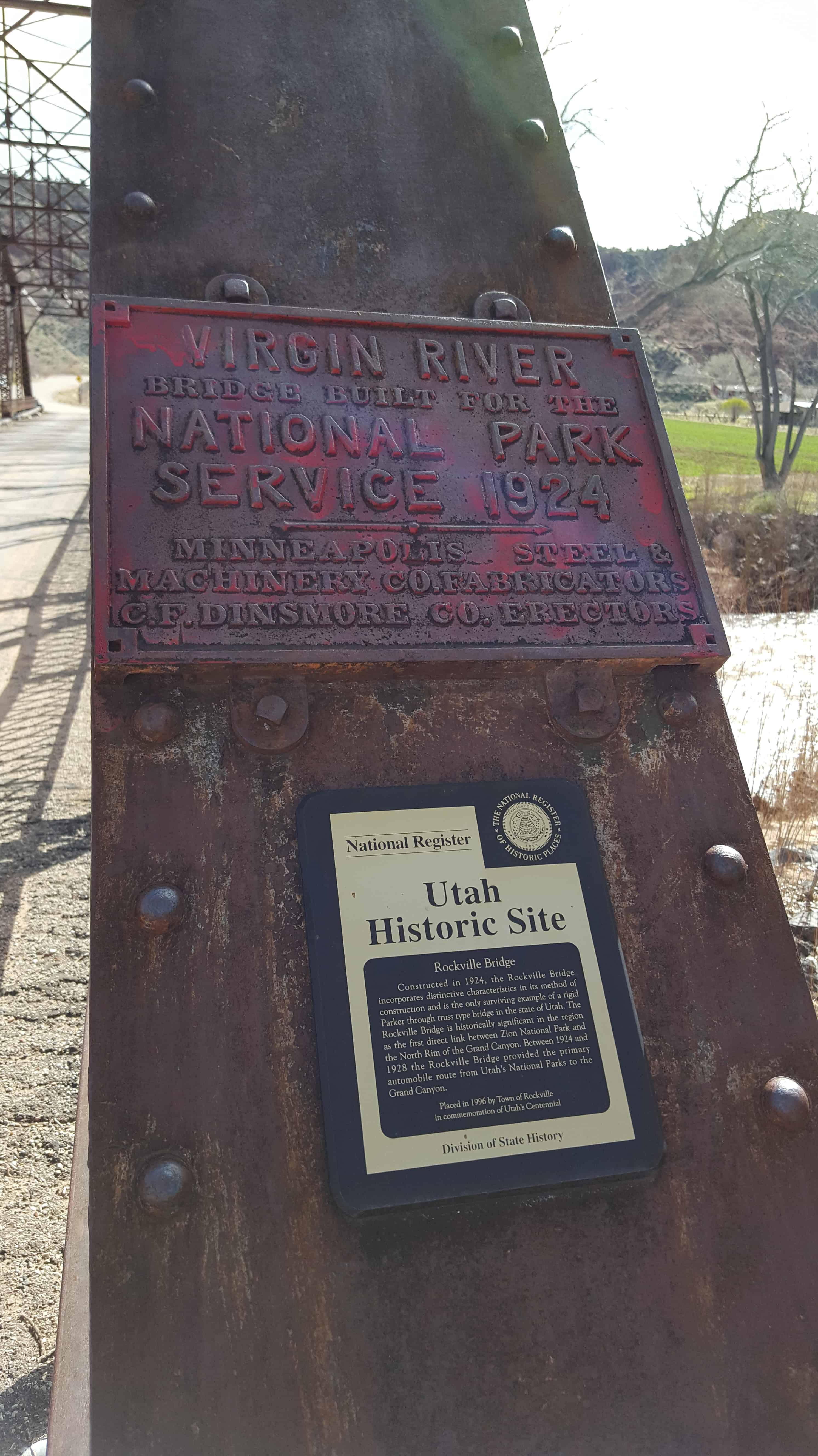
The Rockville Bridge spans the east fork of the Virgin River in Rockville. The bridge was built for the National Park Service in 1924 to provide a link between Zion National Park and the North Rim area of Grand Canyon National Park. The new bridge allowed motorists to take a circular tour of the national parks in southern Utah and northern Arizona. The Rockville route was superseded in 1928 by the construction of the Zion-Mount Carmel Highway.

The bridge was designed by the U.S. Bureau of Public Roads for the Park Service, fabricated by the Minneapolis Steel and Machinery Company, and erected by Ogden contractor C.F. Dinsmore. The bridge spans 217 feet in a single span, using a steel twelve-panel Parker through-truss.

The Rockville Bridge was placed on the National Register of Historic Places on August 4, 1995.

2017-03-04 14.54.11

2017-03-04 15.02.44
2017-03-04 14.57.28
2017-03-04 14.56.28
2017-03-04 14.56.23
2017-03-04 14.54.56
2017-03-04 14.54.49
2017-03-04 14.54.16
2017-03-04 14.54.11
2017-03-04 14.53.54
2017-03-04 14.53.47

Navajo Bridge

08 Sunday Jan 2017

Posted by Jacob Barlow in Uncategorized

≈ 1 Comment

Tags

Arizona, Bridges, Coconino County, historic

picture20sep08-042

NAVAJO BRIDGE, sometimes called Marble Canyon or Grand Canyon Bridge, is the only highway bridge crossing the turbulent Colorado for approximately a thousand miles–from Boulder Dam to Moab, Utah. An engineering accomplishment and an object of great beauty, it is 834 feet long, has a single arch with a span of 616 feet, and measures 467 feet between its floor and the surface of the river–about the height of a forty-story building. Since its completion in 1929 the bridge as superseded the old Lee’s Ferry nearby.
The Colorado River is the western boundary of the Navajo Reservation, largest in the United States.

Since the American Guide was published, a second bridge was built to withstand today’s traffic, the original bridge is now only open to pedestrians, and a visitor’s center replaced the rest area.

“After completion of the new bridge, the old rest area on the west side of the bridge was remodeled and expanded to include an interpretive center. On the Navajo Nation (east) side of the bridge, there is an area for Native American craft vendors. The Navajo Bridge Interpretive Center opened for business in April of 1997 and was dedicated on June 17, 1997.” Source: NPS Navajo Bridge Interpretive Center (visit link)

picture20sep08-033

picture20sep08-034
picture20sep08-035
picture20sep08-038
picture20sep08-039
picture20sep08-040
picture20sep08-041
picture20sep08-043

Cameron, Arizona

08 Sunday Jan 2017

Posted by Jacob Barlow in Uncategorized

≈ 2 Comments

Tags

Arizona, Bridges, Cameron, Coconino County, Historic Markers

IMG_20170312_112150_990

picture20sep08-046

Cameron (Orinally Tanner’s Crossing)

Named for one of Arizona’s first U.S. Senators. A pioneer in development of trails and copper mines in Grand Canyon. Near here was the site of Tanner’s Crossing of the Little Colorado River on The Mormon Trail from Utah via Lee Ferry to settlements in Arizona and Mexico.

n 1911, a sway-back, one-track suspension bridge was erected over a gorge of the Little Colorado on the edge of Navajo and Hopi country. Hubert and C.D. Richardson built a small trading post there in 1916.
Designer – Midland Steel Co.
Location – Cameron, Arizona, USA
Date – 1911
Building Type – Transportation
Construction System – Concrete, Steel, Aluminum
Architectural Style – Suspension-truss hybrid
Street Address – Carries US 89 over the Little Colorado River
Notes – also known as Cameron Bridge;Little Colorado River Bridge

picture20sep08-044
picture20sep08-045
picture20sep08-047


2017-03-12 11.08.03
2017-03-12 11.08.05
2017-03-12 11.08.10
2017-03-12 11.10.58
2017-03-12 11.11.01
2017-03-12 11.12.01
2017-03-12 11.12.18
2017-03-12 11.12.21
2017-03-12 11.12.28
2017-03-12 11.12.37
2017-03-12 11.12.42
2017-03-12 11.12.45
2017-03-12 11.28.20
2017-03-12 11.28.40
2017-03-12 11.28.57
2017-03-12 11.29.01
2017-03-12 11.29.52
2017-03-12 11.29.57
2017-03-12 11.36.21
2017-03-12 11.36.24

Dewey Bridge

03 Saturday Dec 2016

Posted by Jacob Barlow in Uncategorized

≈ 1 Comment

Tags

Bridges, Dewey, Grand County, historic, NRHP, utah

  • picture24jul07-030

The Longest Wooden Suspension Bridge in Utah, in Dewey.  The classic, historic bridge was burned in 2008 and replaced.

  • picture24jul07-031

Built in 1916 – Restored in 2000

The Dewey Bridge, constructed in 1916, is on the National Register of Historic Places. In its prime it was designed to support the weight of 6 horses, 3 wagons and 9000 pounds of freight. It is significant for its outstanding Engineering Accomplishment and for its Historic role as a vital transportation and commercial link connecting Southeastern Utah with Colorado and other points east. In the early decades of the twentieth century, Moab and other Southeastern Utah towns were dependent on communities in Western Colorado for everyday supplies, and markets for their agricultural products. This Bridge, which spans the formidable natural barrier of the Colorado River, was the first to provide a direct connection. Dewey Bridge is Utah’s longest suspension bridge, and at the time of its construction, was the second longest suspension bridge west of the Mississippi. It is also the State’s longest clear span bridge.

Ocean-to-Ocean Highway Bridge

19 Wednesday Oct 2016

Posted by Jacob Barlow in Uncategorized

≈ 1 Comment

Tags

Arizona, Bridges, historic, Yuma, Yuma County

picture27nov08-104

Ocean-to-Ocean Highway Bridge

Constructed – 1915 & Rededicated – 2002

The bridge was constructed in 1915 through a joint effort between the Office of Indian Affairs and the states of California, Arizona and New Mexico to promote traffic along the Ocean-to-Ocean Highway. The bridge was the only one over the Colorado for 1,200 miles. The bridge has no center pillar because of the Colorado River potential roughness.

During the 1930s, California California erected a checkpoint on their side to prevent jobless Oakies and Arkies from entering.

The bridge stopped operations in 1988. In 2002 it reopened to one way traffic only. The Ocean-to-Ocean Highway Yuma” sign was restored and is illuminated at night.

picture27nov08-103

Dewey, Utah (Originally Kingsferry)

03 Tuesday May 2016

Posted by Jacob Barlow in Uncategorized

≈ 1 Comment

Tags

Bridges, Grand County, historic, Moab, utah

picture24jul07-032

Dewey is a ghost town. Originally named Kingsferry, it began in the 1880s when Samuel King built and operated a ferry across the Grand River (now considered part of the Colorado River). A small community soon developed around the ferry. The town served as a ferry crossing until the Dewey Bridge was constructed in 1916.


Follow Jacob

Follow Jacob

Social and Other Links

BarlowLinks.com

Blog Stats

  • 742,525 hits

Recent Posts

  • 233 N 300 W
  • Patsy Vario Jr. Memorial
  • 95 E Center St
  • 40 N 100 E
  • Miles Goodyear Cabin

Archives


Loading Comments...