Tags
Cabins, Centerville, Davis County, DUP, Historic cabins, utah
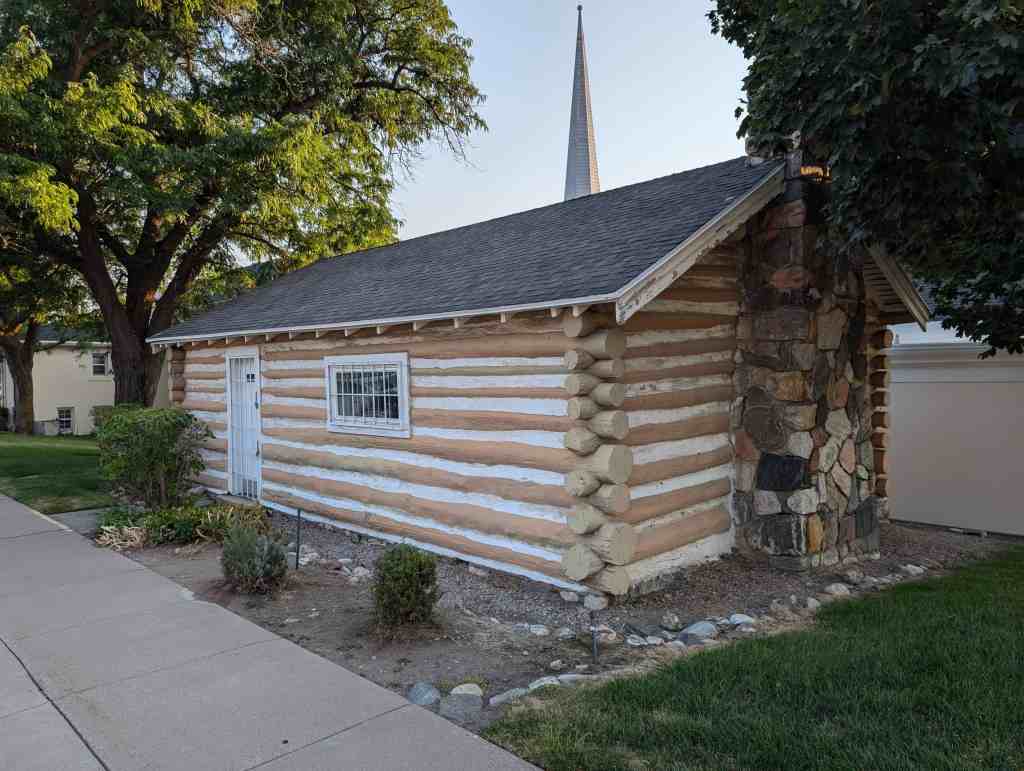
Centerville Pioneer Memorial Cabin on the site of the Centerville 1879 Church.
110 South 300 East in Centerville, Utah


17 Wednesday Dec 2025
Posted in Uncategorized
Tags
Cabins, Centerville, Davis County, DUP, Historic cabins, utah
Centerville Pioneer Memorial Cabin on the site of the Centerville 1879 Church.
110 South 300 East in Centerville, Utah
20 Wednesday Dec 2023
Posted in Uncategorized
Tags
Dr. John Parsons Cabin Complex
Brown’s Park, situated in the western foothills of the Uintah Mountains, has been of historic importance since its first use by Indians and trappers as a winter retreat. In later years Brown’s Park became famous as a hideout for cattle rustlers and outlaws.
Dr. John D. Parsons was a pioneer in the truest sense. Born in Quincy, Illinois, on February 26, 1818, he came west in 1858. It was John Parsons who built the Dr. Parson’s Cabin in Brown’s Park sometime between 1874 and 1876. Before his arrival in Brown’s Park, Parsons owned a valuable ranch in what is now the central part of Denver. A man of progressive views Parsons lost a large fortune in an attempted construction of a huge irrigation project. About 1862 he settled on a ranch on the Green River below Green River City, Wyoming. Here he became a successful cattleman. He also established and operated a ferry across the river which was used by many travelers on the Oregon Trail. Sometime in 1865 or 1866 Parsons returned to Denver. In 1866 he aided in the organization of the Colorado Stock Growers Association and helped to compile the bylaws of that organization. In 1863 he served as president of the association. John Parsons was also a miner and smelter by profession. He brought dies to Denver which established the Denver Mint and aided in the minting of $2.50 and $5.00 gold coins. He also had a dairy farm in the vicinity of the present Denver Stock yards. In the 1872 directory of Denver, Dr. John D. Parsons is listed as a practicing physician at the Springbank House.
Sometime between 1874 and 1876, John Parsons moved from Denver to Brown’s Park and built what has become known as the Dr. Parson’s Cabin. Written accounts establish the fact that the cabin had been built before the fall of 1876. The maps of the A. D. Perron survey of August 15, 1878 show the location of the “Dr. Parsons” cabin in Section 36 Township 2 North, Range 24 East, Salt Lake Meridian. Dr. Parsons lived at the cabin until his death in 1881. He is buried approximately a quarter mile north of the cabin. The Parson’s family left Brown’s Park in 1884.
The cabin is significant for several reasons. It served as the home for Dr. John D. Parsons from the mid 1870’s until his death. John Parsons is representative of the “jack-of-all-trades” who, because of their many and diversified skills and talents, were of great importance in the development of the West. John Parsons was a cattle rancher, President of the Colorado Stock Growers Association, dairy farmer, irrigation promoter, ferry operator, smelter, and practicing physician.
Until the cabin was abandoned in 1884, it served as a popular stopping place for travelers on the Fort Bridger–Green River City–Rock Springs Road to Vernal, via Brown’s Park.
Following its abandonment the cabin was used from time to time as a temporary residence for outlaws who inhabited the area. The most famous of these outlaws who used the cabin were Butch Cassidy and Matt Warner. It was in the nearby spring house where according to local accounts Matt Warner’s wife broke her leg, eventually resulting in an amputation and later, her death.
Recognized locally as an important historic site, the Daggett County Historical Society has been active in restoring the old structure.
The text on this page is from the nomination form from when this site was added to the National Historic Register (#76001812) on November 21, 1976.
Coordinates: N 40.86449 W 109.14625
The Dr. Parson’s Cabin Complex is located in the Brown’s Park area in the extreme northeastern corner of the state near the Utah-Colorado border. The site is near the mouth of Sears Creek as it flows into the Green River from the south. The complex consists of the following structures:
The original two room Dr. Parson’s Cabin constructed between 1874 and 1876. The cabin measures approximately 15 feet by 33 feet. The walls are constructed of logs to the square while the gable is of frame construction and covered with sawed boards. A wooden floor has been installed since the original construction. The roof has been covered with wooden shingles.
Forty-five feet east of the cabin is the springhouse. Constructed over a natural spring, the 7 foot by 10 foot building has been reconstructed within the last several years. The building was built of logs with a dirt roof.
Approximately 65 yards west of the Dr. Parson’s cabin is a 15 foot by 18 foot log structure which served as a blacksmith shop. The logs are joined with saddle notching while the roof consists of cedar and cottonwood poles covered with dirt.
A third cabin is separated by the Dr. Parson’s Cabin and blacksmith shop by a small grove of fruit trees surrounded by a fence. It lies approximately eighty-five yards south/southwest of the Dr. Parson’s cabin. The cabin is 15 by 18 feet with a 4% foot front porch on the east end. This cabin was constructed c. 1920 by subsequent owners of the property. It apparently served as a bunkhouse or guest house. It is chinked with cement and gravel. The cabin lies at the base of a hill which forms the back of a protective cove in which the complex is located.
Approximately 15 yards east of this cabin is a rock faced dugout which was used for storage. The entire complex is located on a site of approximately 2.5 acres.
During the last few years, two houses constructed on the site in c. 1930 were torn down as was a wind mill used to generate power for the ranch.
08 Friday Dec 2023
Posted in Uncategorized
Tags
John R. Nielson Cabin
The John R. Nielson Cabin, built in 1949-1950, in Manti Canyon, Utah, is significant under Criteria A and C as one of only a few remaining historic log cabins in the Manti-La Sal National Forest. It is the only surviving example of an “isolated” cabin, as described by the United States Forest Service (USFS), in Manti Canyon. The history of the cabin represents changes in USFS policies concerning the private use of public lands, particularly concerning summer homes and cabins. In the first quarter of the twentieth century, the USFS encouraged recreational and commercial use of public lands through a system of special use permits. The ongoing dialogue on the status of the cabin documents both the controversy and cooperation that characterizes the relationship between government officials and private local interests regarding public lands in Utah and the western Untied States. The Nielson Cabin represents a mid-twentieth-century example of this relationship. The cabin is also significant for its importance to the surrounding community. The Nielson Cabin was originally built as a hunting-recreational cabin by the extended family of John R. and Alice J. Nielson, and members of the Nielson family have maintained and used the cabin for over fifty years, but it has also been a resource to the neighboring communities. Scouts, church and 4-H groups, hunters, skiers, honeymooners, and many others have used the cabin through the years. The USFS supervised the construction of private cabins and the Nielson cabin is architecturally significant under Criterion C as a surviving example of the influence of the USFS design guidelines on rustic style cabin construction. The Nielson Cabin has excellent historic integrity and is a
contributing historic resource in the Manti-La Sal National Forest of Utah.
Located in the canyon east of Manti, Utah and added to the National Historic Register (#03000772) on June 8, 2004.
The Manti-La Sal National Forest is located in the mountains of central Utah. The forest is largely pine and
aspen, and located along the eastern one-third of Sanpete County. The area was originally home to the local Sanpitch Indians and also used by Ute Indians as a winter base. The first non-native settlers were members of the Church of Jesus Christ of Latter-day Saints (LDS or Mormon Church) who arrived in 1849, two years after the settlement of Salt Lake City. The settlers chose the Manti area because of the nearby warm springs, abundant limestone, and land for farming and grazing. After a decade-long period of confrontation with the native tribes, a dozen communities were founded by the 1860s. Sanpete County was established in 1850 with Manti as the county seat. The population of the county grew from 365 in 1850 to 11,557 in 1880, primarily due to a large influx of Scandinavian converts to the LDS Church.
The rapid growth of the Utah’s population had a deleterious impact of the nearby forests. Because years of
unregulated logging and overgrazing had denuded the mountain slopes by 1890, forest and rangeland
deterioration had become critical. The Forest Reserve Act of 1891 authorized the federal government to set aside forest reserves for the protection of timber and watersheds. In 1905 Congress transferred responsibility for these national forests to the newly created Forest Service. The Manti National Forest (later called the Manti-La Sal National Forest) was one of six national forests established in Utah. During the first quarter of the twentieth century, the USFS developed a system of special use permits for private use of the forestlands. The first permits were issued for the development of waterpower. An early power plant was built just east of Manti at the mouth of Manti Canyon. Other permits were issued for lumber operations, and livestock grazing and related facilities. The residents of Manti and other communities in Sanpete County had a long history of using the water, timber, and other resources of the canyon. By the early twentieth century there were a number of mills, quarries, logging camps, and livestock facilities in the canyon. Because agriculture was difficult due to the lack of water, livestock was the most important economy of the area. A number of early ranchers had permits for ranges in the canyon. In an ongoing effort to preserve the canyon, the Forest Service began reducing the number of grazing permits over the years.
In the period following World War I, there was rapid growth in the number of people wishing to use the
national forests for recreation, particularly with the increase in mobility that accompanied automobile usage. By the mid-1920s, there were large increases in private motoring, group tours, picnicking, and hotel and resort guests. The Forest Service (and the National Park Service) began a program of recreational land management that included road building and other facilities, especially in the scenic venues such as Zion and Bryce Canyon National Parks. Because the Manti National Forest and Manti Canyon were somewhat isolated and boasted no scenic wonders comparable to Zion or Bryce Canyon, the recreational use of the canyon was mostly limited to local hikers, campers, hunters, and skiers. In an effort to increase the number of recreational uses of the area, the Forest Service issued special use permits for small private vacation cabins or summer homes. An advertisement dated June 1931 proclaimed “vacation home” sites on national forest land could be obtained from the government for a $5 a year perpetual lease, and for another $7.50 the government would supply the lumber.
In the summer of 1932, John R. Nielson, a resident of Manti, applied for a special use permit to build a log
cabin approximately nine miles up Manti Canyon. John Rudolph Nielson, Jr., was born in Manti on January 21, 1888, the son of Norwegian immigrants. He married Alice Johnson on June 25, 1913. Alice Johnson was born in Manti on May 7. 1889. The couple had seven children: Errol, Eve, R. Lynn, Martha Alice, Margaret, John Henrie, and VeLois. John R. Nielson was a schoolteacher in Manti. He also worked at a variety of jobs, including chicken ranching, to supplement his teaching salary. During the summers, he would take his three sons up Manti Canyon to cut firewood for the winter. The group usually camped in the canyon for two weeks at a time. After two or three years of camping, John R. Nielson decided to apply for a permit to build a cabin. The Forest Service reviewed the permit in August 1933 and the cabin was completed the following year. The official permit was issued in April 1935. The cabin was located on a hill above the North Fork Road within sight of Swen’s Spring. The cabin was small, constructed of pine logs with a dirt roof and a sod floor. The cabin had only three small windows. A lean-to, called the “Kickin’ Coop,” was added to the west side for an additional bedroom. The cabin was used as a home base for wood chopping and deer hunting, but also for family camping and ski trips. The cabin was authorized as a free-use permit, which required the cabin to be open and stocked with supplies for anyone in the area who might require shelter.
On March 7, 1947, the Forest Service informed the Nielson family that the cabin no longer met the
requirements for a free-use permit. Three days later Ranger Merrill Anderson amended the permit stating “Old Cabin to be removed and new one constructed in its place on a new location near by.”6 According to the Nielson family, the Forest Service was concerned the cabin was too close to the road and Swen’s Spring, which was attracting more traffic each year. The cabin also did not meet current guidelines for cabin construction. The old Neilson cabin was demolished in 1948. Both the new site (hidden from view on a ridge approximately 200 feet north of the road) and the construction blueprints were provided for the Forest Service’s approval. A Timber Sale Permit for the new cabin was obtained, and logs were cut in 1948. Construction on the second Nielson cabin began in the summer of 1949. John R. and Alice Nielson, their seven children with spouses and friends helped to build the new cabin, which was completed in 1950.
Assignments were given to each family member to be responsible for a part of the cabin. Those who did not live close by sent money. John R. and John Henrie Nielson selected the secluded location and built a road to the site. Martha Alice, Margaret and Eve hauled the rocks for the foundation. Errol built the chimney, fireplace and stove. Lynn mixed the cement. John R. and Alice J. Nielson were responsible for building most of the walls. Alice Nielson did most of the chinking .herself. The roof was installed and the concrete floor poured at about the same time.
The construction of the cabin followed guidelines for summer homes developed by the USFS in the late 1940s. The foundation was low to the ground with the exterior chimney constructed of stone. The logs were peeled and roughhewn. The tin roof was painted green to comply with Forest Service stipulations that the exterior colors blend with the surrounding landscape. In the spirit of their pioneer ancestors, the Neilson family used only hand tools to build the cabin. The only tools used were the bare minimum: ax, adz, hammer, shovel, pick, handsaw and pole peeler. Photographs were taken of the cabin throughout the construction process.
The construction of the second Nielson Cabin was one of the few examples regulated by the Forest Service. In addition to the first Nielson cabin (1932-1948), there were about a dozen historic isolated cabins in the canyon potentially under the Forest Service’s jurisdiction. Most of the cabin sites were cleared by the Forest Service after the owners failed to maintain them. The oldest may have been the cabin near Al Johnson Hill (built by loggers possibly as early as the 1890s and demolished by the 1920s). Further up the canyon from the site of the old Nielson is the site of a cabin built by Alex Nielson, a brother of John R. Nielson, built around 1937. This cabin was demolished by the 1950s. Near Logger’s Fork is the site of a cabin reportedly built by cattlemen in the 1940s, and used as a camp and for equipment storage. This cabin was demolished after a few years of use. The Wallace Tatton cabin, near Lowry Fork, was built about 1936 as a logging camp. The cabin eventually rotted away and little remains of the structure.
At the upper end of Lowry Fork is Clark Kellars campground, a hunting camp from the 1930s. There is no
structure, but the campground is still in use today, although not an official Forest Service campground. Alt
Stringham’s camp was a tent on a wood frame over a wood floor. Stringham never had a permit to use the site, and the semi-permanent camp was eventually demolished after a couple years of non-use (date unknown). The City Cabin on the Bench Road was built to house equipment for the water pipeline (built around 1937 and demolished circa 1970s?). The Scout’s cabin was built around 1930 in an area between the North and South Fork Creeks. The log cabin in the pines was demolished at an unknown date, probably in the 1970s. In the Burnt Hill area was the Homer Jay (Jr.) Cox and Carl Peterson cabin, built in the late 1930s, by Cox and Peterson as a hunting cabin. The two men were reportedly discouraged by Forest Service restrictions in the canyon and lost their “zeal to own and use” the cabin. The cabin changed hands several times until the 1980s, when it fell into disrepair and was demolished. The Nielson Cabin is the only extant example of an isolated cabin in the canyon.
By 1950, the Forest Service had instituted an “Approved Summer Home” program that encouraged summer homes to be grouped together in one location. In Manti Canyon, this site was located near the South Fork Creek crossing. The Summer Home Area includes three historic cabins, the Morris Pack, Leland Anderson, and Edward Sorensen cabins. They were built between the late 1930s and early 1950s, and at least two of these cabins have been remodeled. Ranger Anderson’s approval of the new Neilson cabin as an isolated cabin in 1947, even after the establishment of the summer home tract, was likely an acknowledgement of the family’s careful stewardship of the original cabin and the surrounding land.
Because the 1947 letter from the Forest Service changed the usage from “free use” to a pay permit, the Nielson family was required to keep the new cabin locked. There was also an increase in the number of non-family members who used the cabin, therefore the Nielson family drew up a set of rules for the new cabin:
1) leave the wood box full,
2) leave the cabin clean,
3) respect the mountain environment,
4) record your visit,
5) lock the door.
The family also began keeping a log of all overnight trips to the cabin by family members and visitors. Though the log begins in the summer of 1954 with a few family-friends outings and the honeymoon of
VeLois Nielson and Dennis Carbine, the comments in the log represent the types of uses for the cabin during the historic period between 1950 and 1953.
The cabin logs indicate a large number of both family and non-Nielson family members used the cabin. Boy Scouts have made semi-annual trips (summer and winter) to the cabin nearly every year since its construction. Deer hunting trips were also annual events. Stanly W. Duncan, the oldest son of Billy and Martha Alice Duncan, suggests that the construction and use (especially the deer hunts) of the cabin was a catharsis and a therapeutic refuge for his father and uncles (most of whom ere World War II Veterans) in the years between the WWII and the Korean War. On August 18, 1956 “nine crazy people” stayed at the cabin for a “Bow & Arrow” deer hunt. A few weeks later on September 22nd, Forest Ranger LeGrand Olson signed the log with these encouraging words, “This is a beautiful spot, and ingenious cabin. Keep it attractive, in repair, and enjoy the canyon.” On October 19th , a group of tourists wrote these words: “Americans sure show lots of hospitality.” In July of 1957 a large group of nine and ten-year-old girls stayed at the cabin as part of a 4-H Club outing. At the end of that month, Margaret Nielson Peterson brought her family and a friend’s family to the cabin. Her friend, Jackie Bryant, wrote: “Didn’t ever think I’d see any place big enough to sleep both the Peterson & Bryant broods. Couldn’t sleep in the night I figured there are 22 beds. We can both expand our families – If we have the courage. Don’t blame Margaret a bit for bragging about ‘the cabin’.”
Though beloved by the Nielson family and the community, the new Nielson cabin was embroiled in controversy from the beginning. In July 1950, before the cabin was finished, Forest Ranger Howard Folger sent a letter to the family indicating the service had no record of a permit for the new cabin. The Forest Service was working toward the goal of authorizing cabin construction only in the Summer Home area. It was also beginning to enforce a policy that required the removal of isolated (and unauthorized) cabins from public lands. Alice J. Nielson spoke to the rangers by phone and received permission to continue the construction work, After the death of John R. Nielson on April 6, 1951, Alice J. Nielson was again required to negotiate with the Forest Service to adjust the ownership of the cabin. In 1954, the permit was authorized for Alice J, Nielson and John H. Nielson. The Forest Service continued to accept the annual permit fee after the death of Alice J. Nielson on November 20, 1979, and John Henrie Nielson in October 18, 1999.
In January 2001, the status of the cabin became the subject of intense discussions between the Forest Service and the Nielson family. The Forest Service initially wished to demolish the cabin in order to comply with its “removal of isolated cabin policy.” Besides the Nielson Cabin, there is currently one other historic example in the Manti-La Sal National Forest, the Whitlock cabin in Mayfield. This cabin, in cooperation with the Forest Service, is being preserved by its local community. The controversy surrounding the Nielsen Cabin highlights the decades-old relationship (marked by both cooperation and tension) between federal oversight of public lands and the local citizens. The Nielson family (with the support of numerous city, county and state leaders) hopes to preserve the cabin as an important historical resource in Manti Canyon. A proposal in which the Nielson family establishes a not-for-profit entity to relieve the Forest Service of maintenance and liability requirements is currently being considered. The compromise has prompted one of the most complete compilations of construction documents, correspondence, anecdotal remembrances and historic photographs of a private cabin
on public land. The John R. Nielson Cabin is probably the best-documented historic recreational cabin in Utah, and is a contributing historic resource in the Manti-La Sal National Forest.
07 Thursday Sep 2023
Posted in Uncategorized
Swasey Cabin was built in 1921 in the heart of Sinbad Country, by Joseph Swasey. The Cabin was built from Douglas Dir from Eagle Canyon near by. Remnants of the Swasey family farm depict the western heritage. The Swasey family grazed livestock in the area for the later part of the nineteenth century. The cabin served as shelter for members of the Swasey family and other cowboys. There is also what is known as “Joe’s Office” and “The Ice Box” near by.
02 Thursday Mar 2023
Posted in Uncategorized
Tags

Moab Cabin
The Moab Cabin is important to the city of Moab because it is a tangible link with the community’s earlier days, and because the history of the cabin in many ways perfectly reflects the progress of history in many of the major economic and social events that have been important to Southeastern Utah and the American West in the last 100 years. Built by Mormon pioneers, used by cowboys who served the area’s cattle boom, owned by the first clerk of the La Sal Forest which had been created to provide sensible management of the region’s fragile ecology, and home to a succession of humble prospectors who brought about Moab’s Uranium boom, the Moab cabin is an important focus for regional history.
Located outside the Moab L.D.S. Church/D.U.P. Museum at 45 North 200 East in Moab, Utah, it was added to the National Historic Register (#80003906) on February 14, 1980.

The original owner was Marietta Pierce Stewart, the third plural wife of Randolph Hockaday Stewart, the first bishop of Moab. In 1879 R. H. Stewart and his three families started south from Rich County, Utah in response to a call of the Mormon Church to settle Emery County (which then included the present Grand County, where Moab is located). They were stopped by the fierce winter of 1879-80 in Huntington, Emery County, where Bishop Stewart built three log houses for his families. They stayed there for one year and in
the spring of 1881 arrived in Moab, Presumably he once again built three log cabins, although that supposition cannot be verified. At any rate, he acquired all of Block 14, the site of this cabin, from Leonidas L. Crapo, the original homesteader. He and his first counselor in the LDS Church, Orlando W. Warner, deeded this block to Marietta, Bishop Stewart’s third wife.
Marietta’s children inherited the cabin, and in 1910 deeded it to John Jackson, a Wild West, yarn-spinning, old-time cowboy. Local tradition claims that John Jackson (ne Hinton) actually built this cabin in the 1890s of cottonwood logs hauled from the creek that ran through Moab. He was rough and tough and enjoyed a good tale, regardless of its veracity. He was raised in Texas and orphaned at eleven, lived with an uncle for a time and got in several scrapes with other cowboys, Indians, and horse thieves. He claimed that when he left Texas the sheriff and his possee wanted him to stay so bad they chased him all the way to the border, trying to get him to come back. After his hasty exit from Texas, he was forced to change his .name. He then became known as John “Jackson,” although he stayed in Arizona with his brother, Bill Hinton, and the two came to Utah together in 1890. In 1891 Jackson drifted up to Moab, spent a night or two, and did not return until 1893, when he settled there. Locally, he got his start as a cattleman as he “roped wild mavericks in the canyons surrounding the Blue Mountains and sold them for $5 a head. John did a lot of trading and finally had a herd of cattle, which he ran down the river.” Local residents insist that he was more of a rustler in the beginning, a common start for cattlemen in the Old West. He worked for a local cattle company and was allowed to rope mavericks for himself, but at the end of the season he had more cattle than the company did! Jackson himself never discouraged tales about his escapades, although he wound up a wealthy man with money to lend to several of the leading families of Moab. During his days on the range he usually kept his wife and family out with him. On their trips to town they stayed in this cabin and eventually lived there. His first wife, Lillian Webb, bore at least one of her children in this cabin and the family was settled there by 1900.
In April 1910, John Jackson officially acquired title to the property from the children of Marietta Stewart for twenty-five dollars. He didn’t keep the cabin long, selling that part of the lot to John E. Dubois in July for four hundred dollars. Dubois in turn sold it to Henry A. Bergh and Howard W. Balsley in November for
four hundred and fifty dollars. Balsley got sole title to the property eleven months later in October, 1911 for six hundred and fifty dollars and has owned it ever since.
Howard W. Balsley, now 92 and the second oldest person in Moab, still owns the cabin and his own experiences give a fascinating glimpse of the process of change in the American West since the early 20th century. By 1908 when Balsley came to Moab, the West had been officially “closed” for almost twenty years. Traditionally, the American West had been a land of wide open spaces, with room for all. The Old Spanish Trail ran through Moab, one of the few points that allowed a relatively easy crossing of the Colorado River. Indian families, Spanish padres, explorers, traders and trappers of various nationalities had passed through the area for centuries. In 1877, the last call of Brigham Young for the settlement of Emery County (which then included Grand County, and Moab) encouraged Mormons to settle there although other residents, mostly bachelor cowboys and traders, were already in residence. The Mormon pioneers initiated a settled order of life which the community had previously lacked and started farming and agriculture on a wide scale (including the cultivation of the famous Stewart peach, bred by the first Mormon Bishop and possible builder of this cabin, Randolph Hockaday Stewart). The main concern any farmer in the desert has always been water. In addition to private effort, irrigation companies organized to raise money back East for the schemes of opening desert land to cultivation. One of these companies originally drew Howard Balsley to Moab.

A native of Pennsylvania, Balsley was living in Indianapolis when he and his sister invested heavily in the stock of a western water company, known variously as the Grand Valley Land and Mineral Company or the Valley City Reservoir Company. This irrigation project was designed to impound water from the washes between the towns of Green River and Moab, opening large tracts of land to homesteaders. Several people settled the land while an Indianapolis bank partially financed the project, selling stock to eastern
investors such as Howard Balsley. After his first job campaigning for the Republicans in 1908, Balsley decided to go West and see what happened to his investment. “I got out here and found that the secretary-treasurer of the company had been spending the money on horse races instead of putting in a concrete dam as he was supposed to have done. They just had an earthen dam. The first big flood that came along, why, away it went. Anyhow, that’s one investment made and lost I never regretted, otherwise I’d have never been out. It was a means to an end.”
“What made you decide to stay?” “Oh, I just liked the country. These red rocks had quite an attraction for me. It was quite romantic in the old stage days, you know.” The Old West wasn’t quite dead in Moab.
After working hard on a farm and saving his money, Howard Balsley accrued the thirty dollars necessary to take the U.S. Civil Service examination, qualifying him to join the U.S. Forest Service. He became the first permanent clerk of the LaSal National Forest, now part of the Manti-LaSal. He started as a clerk and
later served as clerk-ranger from 1909 to 1918, during the tenures of four of the first five supervisors: John Riis, Henry A. Bergh, J.W. Humphrey and Samuel B. Locke.
The creation of the National Forest Service resounds to the credit of President Theodore Roosevelt. The American Forestry Association was founded in 1875 at the urging of Gifford Pinchot, an early conservationist. The government reacted unenthusiastically, but by 1891 Congress authorized the President to create forest reserves; which he did immediately. These reserves underwent several changes of title and control, but by 1905 the Forest Service was in operation under the Department Agriculture, where it remains today. “The LaSal Forest Reserve was established by proclamation on January 25, 1906. The Monticello Forest was established by proclamation on February 6, 1907; and the LaSal and Monticello were consolidated on July 1, 1908. By the time Howard Balsley became forest clerk in 1909, the previous temporary clerk had quit and he was left to do the clerical work of the entire forest, stretching over a wide area in Grand and San Juan Counties in Utah and Mesa and Montrose in Colorado.
Balsley lived in Moab , boarding for a while with the Forest Supervisor, Henry Bergh, and his wife Zena in the house where Balsley now lives. He and Bergh together bought the log cabin, situated on the same block as the present Balsley residence.
After purchasing the cabin, Balsley moved in there for a short while with his friend, Loren L. “Bish” Taylor, who became the second owner and editor of the Moab newspaper, The Times Independent. The two men lived in the cabin only a short time while they built a frame structure directly to the south; it had room for some cupboards and was generally more spacious. (This frame dwelling is now part of the main structure of the “Atomic Motel,” a name undoubtedly coined during the uranium boom of the 1950s.) Balsley’s parents came out for a visit in 1910 and stayed almost a year in the log cabin. His father put a glass window in the front door, apparently the only alteration in the building since its construction.
In 1912 Howard Balsley married Jessie Trout, a local girl whose father, Tom Trout, was one of the wild Texas cowboys to settle in the Moab area. Tom Trout lived in this cabin, too, for three or four years before his death on July 15, 1939. Trout had run cattle in Texas and participated in the big cattle drives to Dodge City, Kansas. He was on the first grand jury in Texas and perhaps thought that made some enemies, for local tradition claims that he was dumped over the Texas state line wrapped in a cowhide. True or not, by 1885 he was in Monticello, Utah, punching cattle. At Christmas 1886, he came to Moab to celebrate (in the hard-drinking, gun-shooting manner of the wild west cowboy) and won ten dollars on the horse race held on Moab’s main street. A local citizen asked if he’d like to buy a town lot. “I just as well invest my money in town lots as anything I know of,” Tom replied. Then he left town, returning in 1888 when the local citizens offered to buy the lot for $1,000 to build a schoolhouse. Impressed by the worthiness of the cause, Trout freely gave them his lot, now the site of the junior high school. He later married Elizabeth Standifird of Moab, became a cattle rancher, county road commissioner, deputy sheriff and miner.

A single-story rectangular log structure. The walls are of rough-hewn logs with mud chinking, unevenly notched at the corners The flat roof is made of parallel logs covered with branches and mud, sporting a final layer of growing plants.
Finally, the cabin is significant because of its ties to Howard Balsley and his career in uranium. Commencing in 1913 while he was still in the employ of the Forest Service, Howard Balsley helped pioneer the development of the Uranium industry in the west. Later, during the uranium boom of the fifties, the cabin was again home to a succession of hopeful prospectors.

20 Monday Feb 2023
Posted in Uncategorized
Tags

The Miles Goodyear Cabin is located outside the Weber County Daughters of Utah Pioneers Museum at 2104 Lincoln Avenue in Ogden, Utah. There are several historic markers that talk about it:
U.P.T.L.A. Marker #41 says:
This cabin, built about 1841 by Miles Goodyear, as far as known the first permanent house built in Utah, stood near the junction of the Ogden and Weber Rivers. In 1848 it was sold to Captain James Brown of the Mormon Battalion with a Spanish land grant covering all of Weber County. It was preserved by Minerva Stone Shaw and by her presented to the Daughters of the Utah Pioneers, Weber County Chapter, who placed it on its present site.
D.U.P. Marker #484 says:
Miles Morris Goodyear built this cabin on the lower Weber River as a way station and trading post. The cabin, along with other buildings became Fort Buenaventura meaning good venture. It was the first permanent settlement in the Utah Territory. Miles Goodyear (1817-1849) had traveled as far as Fort Hall in 1836 with Dr. Marcus Whitman’s party of Methodist Missionaries. Goodyear was a trapper, prospector and trader. His Indian wife Pomona was the daughter of Ute chief Peet-teet-neet. The couple had two children, William Miles and Mary Eliza.
Mormon Battalion Captain James Brown and Mary Black Brown bought Fort Buenaventura and all of Weber County for $1,950 in gold. Mary Brown made the cabin home for her family and made 1,000 pounds of cheese during the first year.
The Browns sold the cabin to Amos P. and Minerva Leontine Jones Stone. The Stone family lived in the cabin for a time, eventually using it as a blacksmith shop. A daughter, Minerva Pease Stone Shaw, in 1926 presented the cabin to Weber County Daughters of Utah Pioneers for preservation. It has been moved seven times, ultimately being placed at this site. In 1994 it was disassembled for preservation of the logs and reassembled in 1995 at this location to benefit posterity.
The Ogden City Landmarks Commission plaque says:
Miles Goodyear came west as a venturesome young man with the Whitman- Spaulding Expedition of 1836. He married a daughter of the Ute Chief, Pe-teet-neet, and located his stockade and cabin on the Weber River. This post became a stop-over and replenishment station for California-bound emigrants. Goodyear called his place Fort Buenaventura.
The cabin was built of sawed cottonwood logs in 1845 by Goodyear. Its dimensions are 14’4″x17’9″. The original floors were dirt. As the foundation logs sat on the ground, they rotted away and have been replaced. In addition, some of the lumber in the door and the windows was sawed after 1847.
Originally located on the Weber River two miles above the Ogden River confluence, the cabin has been moved several times. In 1928 it was donated to the Daughters of the Utah Pioneers.


The cabin was added to the National Historic Register (#71000866) on February 24, 1971.
The earliest permanent white settlers in Utah were trappers and traders. In the Miles Goodyear cabin the story is told of the transition from trap- per and trader to settler. Goodyear came west as a venturesome young man with the Whitman-Spaulding Expedition of 1836. At Fort Hall on the Snake River in present-day Idaho, he left the party to become a mountain man.” In time he married a daughter of the Ute Chief, Pe-teet-neet, and located his stockade and cabin on the Weber River. This post became a stop-over and replenishment station for California-bound emigrants. Goodyear called his place Fort Buenaventura.
Goodyear combined his trapping ventures with trading as far afield as California. On July 10, 1847, he met the advance party of the first Mormon emigrants at Bear Lake bottoms, where he talked with O. P. Rockwell, George A. Smith, Erastus Snow, and Norton Jacobs.
The new emigrants soon became interested in Goodyear’s holdings. James Brown saw them in August, 1847. After returning from California with Mormon Battalion payrolls, Brown pursued this interest and was per- mitted to negotiate with Goodyear who sold his properties for $1,950.00. The original claim included about 225 square miles, nearby all of present Weber County.
Brown moved in by March, 1848. The site became known as Brown’s Fort, Brown’s Settlement and, subsequently, Brownsville. The name Ogden was be- stowed officially in 1851.
Only the cabin remains of Goodyear’s Fort Buenaventura. But through it, this important transitional part of American and Utah history can be told.
30 Wednesday Nov 2022
Posted in Uncategorized

About 1000 ft. west of this spot is the site of the first cabin built in this valley in the summer of 1877 by Abraham Powell.
This marker erected by Explorer Troop #284
Nov. 1936 – Wm Campbell, SM.

Vincent Paul Anella Troop 296
Eagle Scout Project
Reestablished marker recognizing the first cabin built in Price by Abraham Powell in 1877. Original marker was at 600 South Carbon Avenue.
December 22, 2011
Price Centennial 1911 – 2011
Chase Greenhalgh, Scoutmaster

This historic marker is located at the 600 South Trailhead of the Price River Trail, approximately 600 South Carbon Avenue in Price, Utah.


30 Wednesday Nov 2022
Posted in Uncategorized

First Cabin on Price Town-Site
This cabin, believed to be the oldest on Price Townsite, was built by Leander Clifford in 1884. The Daughters of the Utah Pioneers purchased the home in 1928 and moved it to the Price Tabernacle site where it was used as an historical relics hall. It was moved to this site approximately 1936.

This historic marker is located in Pioneer Park in Price, Utah and was dedicated by the Utah Outpost Mountain Charlie Chapter No. 1850 of E Clampus Vitus on July 26, 1980.


29 Tuesday Nov 2022
Posted in Uncategorized

Grames Cabin
This cabin, believed to be one of the oldest in Castle Valley, was built on Gordon Creek by Albert Grames in the early 1880’s. It was moved to Price in the year 1900 and used as a Grames family residence until 1964. Albert Grames, in addition to being one of the first settlers in Castle Valley, was also the first mail carrier and worked in many public service capacities including sexton. The cabin was restored on this site by Utah Outpost in 1985.
This historic marker is located in Pioneer Park in Price, Utah and was dedicated by the Utah Outpost Mountain Charlie Chapter No. 1850 of E Clampus Vitus on August 3, 1985.
This historic marker by the D.U.P. is also on the same cabin:


02 Wednesday Nov 2022
Posted in Uncategorized
Tags

Joseph “Cap” Hill Cabin
After sitting 161 years on its original building site, the Joseph “Cap” Hill cabin was moved to Layton Commons Park in 2017. This cabin is one of the oldest pioneer buildings in Davis County. It was built by Joseph Hill Sr. and his family between 1851 and 1854 and has been in the possession of the Hill family for over five generations.
Joseph “Cap” and Edith Ann Hill
Born in Gloucestershire, England, Joseph and his wife Edith Ann Marsden Hill, joined The Church of Jesus Christ of Latter-day Saints and immigrated to America in the 1840s with their three children – John C., Joseph Jr. and Alice Ann. They lived in Nauvoo, Illinois for a time and then moved to Utah Territory in September 1850. After arriving in Salt Lake City, the Hill’s move to the Kay’s Ward (later Kaysville) settlement to establish a permanent home. During this exodus across the plains, Joseph served as a captain of 10 wagons, under the direction of Mathew Caldwell, a captain of 50. For the rest of his life, Joseph would be remembered as “Cap” or “Captain” by his many friends and neighbors.
Joseph Sr. and his family worked hard to build a new homestead in what is now West Layton, on the west side of Angel Street. Once the cabin was built, the family established a farm where they raised hay, grain crops and cattle. In the late 1850s, Joseph Sr., hoping to seek his fortune in the gold fields, moved his family briefly to Sacramento, California; however, they returned to Utah in 1862. While passing through Carson City, Nevada, Edith Ann was critically injured in a wagon accident and died on July 4, 1862. After burying his wife, Joseph Sr. returned to Kay’s Ward and took up residence once again in the cabin he had built. He lived there until his death on august 21, 1889; and he was buried in the Kaysville City Cemetery. Following his death, the cabin was used for a variety of purposes until it fell into disrepair.
Eventually, the cabin passed into the possession of Joseph Sr.’s 2nd great-granddaughter, Odessa Webster Hill Harris and her husband Robert Jay Harris. The couple restored the cabin to its current condition in 1990. In 2000, the Harris’ built a beautiful home on the Hill property next to the cabin and cared and looked after the property until their passing in 2017. After their deaths, the cabin was moved to its current location where it serves as a reminder to Layton citizens as well as to all visitors who see it of those who came before us.
Related:


Located at Layton Commons Park at 437 N Wasatch Drive in Layton, Utah
The Joseph Hill Family Cabin, built sometime between 1851 and 1858, is a one-story single-pen log cabin, located at 2133 W. 1000 South in Layton, Davis County, Utah. After a period of vacancy and deterioration, the cabin was rehabilitated around 1990 when it was raised and placed on a concrete pad. The rehabilitation included replacement logs from a derelict barn on site, re-chinking, replacement windows and interior casings, gable trim, an interior brick chimney, drop ceiling, and a new roof with wood shingles. Despite these modifications in some materials and workmanship, the Hill Family Cabin retains its historic integrity in terms of location, design, feeling and association of a pioneer-era log cabin. Although the immediate setting of the cabin has been compromised by the landscaped yard, the wider setting is still rural as much of the original farmstead remains agricultural. A new home built on the 1.53-acre property in 2000 is non-contributing. There is also an associated historic outhouse near the log cabin, but the outhouse has been modified and moved, and is therefore considered non-contributing. The Joseph Hill Family Cabin is one of four extant log cabins in the Layton area and the only example that still retains its domestic appearance. The cabin is a contributing resource in its Layton neighborhood.
The Joseph Hill Family Cabin sits on roughly rectangular property of 1.53-acres, a combination of two descriptions into one legal parcel. The cabin is located at the southeast corner of the property in the backyard of the non-contributing house, built in 2000, facing north to 1000 South. The new house was built where a one-story red brick Victorian-era cottage was located before it was destroyed by fire in the 1970s. The property is mostly lawn with pasture on the three adjoining sides. There is one mature elm tree located north of the cabin. This tree is the only remnant of the copse that surrounded the cabin prior to the rehabilitation. There are newer trees with decorative boulder plantings scattered in the backyard. A non-contributing gazebo structure is in one of the plantings. Just south of the cabin in one of the plantings is a wood outhouse. Although historic and associated with the cabin, the outhouse was recently moved and does not retain sufficient integrity to be contributing. There is also new gazebo west of the cabin.
The West Layton neighborhood at the intersection of 2200 West and 1000 South retains a rural feeling despite recent construction activity in the area. There are newer homes on either side of the cabin property, but there is pasture between. A new barn sits southwest of the log cabin on a separate legal parcel. There are onion fields to the north of 1000 South. To the south is undeveloped open pasture, further south and west are marshes at the edge of the Great Salt Lake. The path of the abandoned Bluff Road is visible in aerial photographs in the vicinity of the Joseph Hill Family Cabin.
The Joseph Hill Family Cabin in Layton, Utah, is locally significant under Criterion A, in three distinct areas:
Exploration/Settlement, Commerce, Transportation, and Ethnic Heritage. The log cabin built by the Hill family is a rare extant example from the early settlement of the area formerly known as West Layton. The exact date of construction is unknown. In local histories, the construction of the cabin has been attributed to either Joseph Hill Sr. upon his arrival in 1851 or his son, Joseph Hill Jr., prior to his marriage in 1858. Both families are considered important early settlers of the Big Field area of West Layton. The Hill cabin was never moved from the family farmstead along the Bluff Road contributing to the cabin’s significance in the areas of Commerce and Transportation. Bluff Road was the preferred route for California-bound gold seekers leaving Salt Lake City to travel around the north end of the Great Salt Lake. The Hill family raised cattle on the flats below the bluff and sold beef and other commodities to the travelers. The family also represents the small minority of Mormon settlers who were lured to California by the promise of gold and silver. Joseph Hill Sr.’s extended family left Layton in 1860 and returned in 1862 after an unsuccessful and tragic journey, which resulted in the death of his wife, Ann Edith Marston Hill. After their return, Joseph Hill Jr. built a red brick house for his wife, Ellen Sheen Hill, and family. During that time Joseph Sr. may have lived in the cabin behind the brick house. The Hill Cabin is the only extant log cabin in Utah that is linked to the Bluff Road and it is the only known cabin in Layton to have continued a residential use into the twentieth century.
The Hill Cabin is also the only documented building in Davis County to be associated with the Japanese soaking tub practice (known as ofuro), which gives the building significance in the area of Ethnic Heritage. The continued maintenance of the log cabin as a residence likely contributed to its easy conversion to a bathhouse/dressing room in the 1940s and 1950s for one of the many Japanese families that rented farms in West Layton. Beginning in the 1920s and continuing into the 1950s, several Japanese families moved to Davis County to become farmers. Because the immigrants were discouraged from owning land, the immigrants share-cropped or rented the farms of older residents. Despite modifications that occurred during a circa 1990 rehabilitation, the building retains many of the characteristics that it had during an exceptional long period of significance that represents a century of productive use. The Joseph Hill Family Cabin is a contributing resource in its West Layton neighborhood.
The history of Layton begins with the history of Kaysville, Utah. In the winter of 1847-1848, just a few months after the arrival of members of the Church of Jesus Christ of Latter-day Saints (LDS or Mormon Church) to the Salt Lake Valley, Hector C. Haight kept a herd of cattle in the area, and in April 1850, William Kay and Edward Phillips raised wheat near what became known as Kay’s Creek. They were later joined by several families. By 1853, the population of Kaysville, which included present-day Layton, was 417. Among the settlers who came in 1850 was the family of Joseph and Ann Hill. Joseph Hill Sr. was born in 1806 in Sandhurst, Gloucester, England. His wife, Ann Edith Marston, was born in 1808 in Norton, Gloucester, England.34 They were married in 1828 and had three children, John Calvert (born 1835), Joseph Jr. (1837) and Alice Ann Marston (1839). The family immigrated to the United States before 1850. Joseph Hill Sr. was designated a captain over a team of immigrants while crossing the plains and was known as Captain or “Cap” Hill for the rest of his life. The family was living in a log cabin on “the salt flats near or on the dividing line between Kaysville and Layton” by time of the 1850 census enumeration. This area was known as the “Big Field.” A hand-drawn map of the early settlement places the Joseph Hill Sr. home north of Kay’s Creek in the northwest quarter of Section 31, Township 4 North, Range 1 West.
Unlike many of his contemporaries, Joseph Hill Sr. did not file for a homestead patent for his land. The first recorded claim to the land was when his son, Joseph Hill Jr., obtained a deed for 159 acres in the west half of Section 31 from the Union Pacific Railroad Company in July 1880. While the exact location of the first home of Joseph Sr. and Ann Hill is unknown, historic records agree that by the time of his marriage, Joseph Hill Jr. lived in a log cabin at the present-day intersection of 1000 South and 2200 West, although neither street existed prior to the 1880s. Joseph Hill Jr. married Ellen Sheen on December 28, 1858. Ellen Sheen Hill was born in 1837 in Berrow, England. She came to Utah in a handcart company in 1856 and settled in west Kaysville with her family. Joseph Jr. and Ellen Hill had two sons and five daughters. They lived in the log cabin until they were able to build a red brick house that faced north to a lane along the north line of Section 31 (today’s 1000 South). The 1870 and 1880 census enumerations show that after Ann Hill’s death in 1862, Joseph Sr. lived next to Joseph Jr. and Ellen. The juxtaposition combined with the Victorian-style windows added to the cabin suggest that Joseph Sr. may have lived in the log cabin on the property until his death in 1889.
By the 1880s, residents of the Layton area wanted to separate from Kaysville, which had been in incorporated in 1868. They questioned Kaysville’s authority to tax their property without providing municipal services. The Layton Ward of the LDS Church, named for early settler Christopher Layton, was established in 1889. The West Layton Ward of the LDS Church was organized in 1895, one year after a court case was decided in favor of the residents. Layton became an independent unincorporated area in 1902 and an incorporated town in 1920. By the time of incorporation, roads along the section lines (e.g. 2200 West) were created to connect to Gentile Street, the main east-west road to the Layton’s growing commercial district and the railroads.
Only a tiny fraction of the thousands of log cabins built by Mormon pioneers exist today. Of the twenty-seven log cabins built before the coming of the railroad that appear in the Utah SHPO’s database of historic resources, seventeen have been moved to museums or city parks for display. For example, the circa 1865 Levi Roberts cabin originally built on Kay’s Creek was moved to This is the Place State Park on the east bench of Salt Lake City in 1977. The Layton area is current represented by only four extant log cabins: the Hill cabin, the Higgs cabin on Fort Lane in East Layton, the Webster cabin on Angel Street (moved 500 feet), and the Kay cabin (moved to Syracuse). More importantly the Hill Cabin is the only surviving cabin that sits on its original farmstead and was associated with the emigrant trail along Bluff Road.