The mobile trader often was the first contact the Indians had with the white man. His products strongly influenced their material culture and economic society. As the middle man, he played a part in their adjustment to the ways of the whites. When the trader later became a resident on a reservation, he provided needed food, as well as materials for Indian crafts, and helped the Indians to adapt to the new environment and culture by advice and encouragement, contributing to the eventual control and adjustment of the Indians. His welfare depended on the Indian and the Indian’s on him.
The Hubbell Trading Post, established in 1878 on the Navajo Reservation, is a unique example of the work of these men. It was the most important trading post on the reservation, has been operated for more than 80 years by the same family, and was the first of a chain of Hubbell posts on the reservation.
Navajo trade was considerably influenced by John Lorenzo Hubbell. He is probably more responsible than any one individual for the development of Navajo crafts as a native industry. He took part in helping them to develop their native economy and to adjust to new conditions. His reputation for fairness and good counsel permeated new trading enterprises from which the Navajos also benefited.
Few changes have been made in the present well-preserved post and house, which replaced a smaller structure about 1900, and barn and utility building. The appearance of these structures, built mainly of native stone, differs little from other trading posts on the reservation. However, the house interior, with furnishings from the late iSOd’s, collections of old Indian crafts, old firearms, paintings, photographs, books, and large numbers of Navajo rugs, reflects the personality and interests of the man and his time.
The Hubbell Trading Post is located in Ganado, Arizona and was added as a National Historic Landmark (#66000167) on December 12, 1960
During the heyday of the Indian trader the Hubbell Trading Post was perhaps the most important trading post in the Southwest. From 1876 through the first two decades of the 20th century the post was the center of commercial, cultural, and social life on the vast Navajo Reservation, and Don Lorenzo Hubbell, founder of the post, the most influential white man on the reservation. The trading post, moreover, became a haven for many noted artists, who enjoyed Don Lorenzo’s famed hospitality while portraying Navajo life. Mr. Hubbell was also active in territorial politics and played an influential role in the movement leading to Arizona statehood.
As a well-preserved specimen of the reservation trading post, this site attains its greatest significance and historical value. The role of the trading post in frontier history has generally been slighted, and in the Hubbell Trading Post, which is still an operating business concern, one may observe this institution functioning very much as it did in the late 19th century.
The post has been in the Kubbell family since its establishment, and great care has been taken to preserve its historical atmosphere. All of the buildings are of stone, solidly constructed and in good condition. The post proper consists of a sales room, a large storage room, and two rooms used as offices. There appears to have been very little modern improvement, either exterior or interior, and the post looks much as it did’in 1890. The room adjoining the office houses many pioneer artifacts, a large portion of the Hubbell art collection, and the records of the post from the beginning. Many works of art also hang on the office walls, together with photographs of prominent persons inscribed to Don Lorenzo Hubbell. One is of Theodore Roosevelt, who at one time was a guest at the post. The Hubbell house, built in the 1890’s, stands behind the trading post. Period furnishings, walls covered with art work depicting Indian themes and personages, an extensive and diversified library, and (like the trading post) viga ceilings covered with Indian basketry, characterize most rooms of the house. Some half-dozen bedrooms open from the large living room, which is dominated by a fireplace. A small patio seta off this area from the dining room and kitchen. Only in the kitchen, equipped with modern appliances, does one lose the flavor of the old post. In addition to the trading post and house, a large stone barn, a corral, and quarters for employees occupy the premises.
BRIEF SURVEY OP OLD NAVAJO TRADING POSTS
In the last decades of the 19th century and the opening decades of the 20th, the institution of the reservation trading post reached its most highly developed and Influential level on the Navajo and Hop! reservations of the Southwest. The character of the Indian trade here has been detailed and its significance assessed in Robert M. Utley, “Special Report on Hubbell Trading Post, Ganado, Arizona,” Santa Fe, 1959. In this report, too, the significance of John Lorenzo Hubbell and the Hubbell Trading Post at Ganado was established and the conclusion reached that the Hubbell Trading Post possesses important historical values and is today the best surviving example of the oldtime trading post.
The following brief survey is intended to reinforce the conclusion that other trading posts do not offer better opportunities for portraying this phase of American history. It is limited to trading posts that originated earlier than half a century ago and that may have an oqual claim In academic significance to that of the Hubbell post.
Assisting in preparing this survey was Superintendent Meredith Guillet of Canyon de Chelly National Monument. As the son of an early trader to the Navajos, Mr. Guillet was reared in the trading environment and is an expert on Navajo trading posts. In a memorandum of February 4, 1963, to the Regional Director, Southwest Region, Mr. Guillet says: “The Lorenzo Hubbell Post at Ganado, Arizona, stands alone as the only one which has retained its original site, buildings, and character. I know of no modern trading post that would remotely approximate in value that of Hubbell Trading Post as a Historic Site.”
Fort Wingate, New Mexico
Port Wingate, having occupied a site farther east during the Civil War years, was established at Ojo del Oso in 1868 to keep watch on the Navajos, who had been permitted to move from captivity at Fort Sumner back to their homeland. The sutler’s store at Wingate at once acquired a large Havajo trade. Frequently changing hands, it endured over the decades as one of the more important Navajo trading posts. The original store is now gone.
Fort Defiance, Arizona
The Navajo Agency was established at old Fort Defiance, a pre-Civil War military post northwest of Wingate, when the Navajos returned from Fort Sumner in 1868. Defiance was the birthplace of the reservation trading post as a Navajo institution. The first post opened concurrently with the agency, and as long as the agency remained here there was a succession of traders and trading posts—none now represented by a historic building.
Keam’s Canyon, Arizona
Among the early traders, Thomas Varker Keam ranks with Hubbell, Cotton, Moore, and the Wetherills in the deep mark he left on the history of the southwestern Indian trade. He established himself at Ream’s Canyon in 1875 and traded there, primarily with the Hopis, until 1902, when he returned to his native England and died two years later. Although Ream’s Canyon is still a major trading center, none of Thomas Ream’s buildings remain to commemorate his activities.
Oljato, Arizona
John and Louisa Wetherill were among the earliest to trade on the remote western portion of the Navajo reservation. They established themselves at Oljato, in partnership with Clyde Colville, in 1906 and traded there with the followers of the famous Navajo chief Hoskinini until 1910. The post has continued to operate since then under a succession of proprietors. The original buildings, however, have been considerably remodeled and modernized.
Kayenta, Arizona
In 1910 John Wetherill moved from Oljato to Kayenta, thirty miles distant, and built the trading post that in the next two decades became one of the most famous in the Southwest. The building is still standing but has been modernized and the former storeroom converted into a lunchroom.
Crystal, New Mexico
J. B. Moore built the Crystal trading post in the Chuska Valley in 1897 and managed it until 1912. His influence on the local blanket makers was marked, and they wove products of high quality and distinctive design that, through Moore’s ambitious promotional program, became widely known in the East. Charles Newcomb ran the Crystal post from 1919 to 1936. It is still active, but the buildings have been remodeled and rebuilt so extensively as to leave little of the original appearance.
Chinle, Arizona
Several posts and traders, including Hubbell and Sam Day, operated at Chinle, but the old posts have either fallen into ruin or disappeared. The present Chinle post, operated by Camille Garcfa, incorporates some of the original walls of Lorenzo Hubbell’s 1886 trading post but has been drastically modernized. It illustrates, says Frank McNitt, the new trend in Navajo trading–“the transition of the Indian trader to super market operator.”
Thunderbird, Arizona
The Thunderbird stands adjacent to the headquarters of Canyon de Chelly National Monument. Sam Day built it in 1898, and after a series of owners it was acquired in 1919 by L. H. McSparron, who named it the Thunderbird. During the 1920s and 1930s it achieved some notoriety because of McSparron’s role in reviving high-quality blanket weaving and because of its guest facilities for visitors to the national monument. Although the original store itself has suffered no major impairment and still serves as a trading center, an adjoining restaurant and motel detract from the historic appearance.
Shiprock, New Mexico
Two trading posts operated near the famous Shiprock landmark in the early years of the century. Walker and Hubbard ran the one now standing and sold it about 1912 to Will Evans. The establishment today operated as the Shiprock Trading Company retains little if any of the original structure.
Round Rock, Arizona
Stephen E. Aldrich founded the post at Round Rock in 1890, and under his aggressive management it swiftly attained important rank among Navajo trading posts. Still an active post, it has been remodeled and expanded, leaving little of the original structure.
Pueblo Bonito, New Mexico
The Pueblo Bonito post was important for its associations around the turn of the century with Richard Wetherill, whose many attainments included success at Indian trading. Wetherill was murdered at his trading post by a Navajo Indian. The Wetherill post has been obliterated and the stone moved to another location.
In this small research laboratory at the University of California at Berkeley, the man-made element Plutonium, was first identified. From that day in February 1941, atomic research continued until ultimately a new source of energy had been developed. Had it not been for the momentous discovery here, neither the atomic explosives used in 1945 to end the War with Japan, nor the subsequent development of nuclear energy reactors would have been possible.
Room 307, Gilman Hall, University of California is located at the University of California, Berkeley in Berkeley, California and was added to the National Register of Historic Places (#66000203) on October 15, 1966.
Although the possibility of extending the periodic table of elements had been considered many times, the hope of extension did not become realistic until 1934, when artificial radioactivity was discovered.
Ninety-two elements were then known, but in 1940, the first of the man-made elements was developed by bombarding uranium with neutrons until it captured a neutron and released an electron, thereby producing a new element, #93, Neptunium, an isotope of Uranium.
A few months, later, five co-workers shared in the discovery of element 94, Plutonium, by the same process. They were: Arthur Wall, Edwin MacMillan, Glenn Seaborg, Emilio Segre, and J.W. Kennedy. By using a cyclotron to bombard uranium oxide with neutrons, they created another isotope, and the one which has been far more important than any other. Plutonium, used in a nuclear fission process, can be and has been used for both power-generation in a nuclear reactor, and as an atomic explosive. Doctors Seaborg and MacMillan later shared a Nobel Prize for their work in this field.
Apache Pass was a much-traveled mountain crossing used by the Chiricahua and other Apaches because of the presence of spring water, an important need to the traveler in this arid country. The Spanish named it Pass of Doubt.
In 1854, after the United States obtained the region by the Gadsden Purchase, Lt. John G. Parke surveyed the pass for railroad use.
Apache Pass and Fort Bowie is located in Cochise County, Arizona and was added as a National Historic Landmark (#72000194) on December 19, 1960
In 1858, the Butterfield Overland Mail Company ran its trail over the pass and established a stage station, which Cochise, the Chiricahua Chief, kept supplied with wood. The Chiricahuas also received their first official ration issue here. In 1861, Lt. George N. Bascom arrested Cochise and a few other Chiricahuas at the pass in an attempt to obtain the return of a small boy allegedly made captive by these Apaches. Cochise managed to escape, and for ten years thereafter led his warriors on one raid after another throughout southeastern Arizona.
In July 1862, Cochise and his warriors, joined by Mogollon Apaches under Mangas Coloradas, battled the advance guard of the California Column in the pass, but were forced to retreat when a howitzer was turned on them. Gen. James H. Carleton, realizing the Importance of the pass and the spring, immediately ordered the building of Fort Bowie, which was to play an important part in campaigns against Cochise and later against Geronimo.
In 1872, Gen. O. O. Howard rode through Apache Pass to discuss peace terms with Cochise, and for a short period, after the Chiricahuas had been assigned to a reservation, the agency headquarters were located in the pass. In 1876, when the Chiricahuas were moved to the San Carlos Reservation, Geronimo led a faction to Mexico from where he periodically raided into Arizona. Off and on for another ten years, troops from Fort Bowie took the field in pursuit of Geronimo and his warriors before their final surrender, thus bringing an end to 190 years of almost continual Apache warfare with Spanish, Mexicans, and Americans in southeastern Arizona.
The spring, aside from a pipe extending out of one side, remains as it was, and well-preserved traces of the Butterfield Trail are evident at various points throughout the pass.
The original fort, badly eroded, stands on a hill overlooking the strategic springs. It was replaced in 1868 by a larger post, the adobe walls of which, in varying stages of erosion, mark practically all the buildings. The stone corrals still stand and the water system still is evident. The pass remains much as it was when used by the Indians.
Mission San Xavier del Bac has served the Papago Indians since it was founded in 1700 by the Jesuit Eusebio Francisco Kino. Bac was then “beyond the rim of Christendom” and formed the extreme northern thrust of Nueva Espana. The present church is the third, perhaps the fourth, on the site; begun in 1783, it was completed in 1797. Since that time it has continued to serve the Papagos under the flags of imperial Spain, revolutionary Mexico, and the young and expanding United States. It has survived heat, storm, earthquake, the neglect of church and state, and the attack of hostile Indians. It continues to stand serene and untroubled against the timeless backdrop of the desert, a strange visitor from another world, completely at home in its alien environment, the most spectacularly lovely gift of colonial Spain to the United States.
San Xavier del Bac Mission is located at 1950 West San Xavier Road in Tucson, Arizona and was added a National Historic Landmark (#66000191) on October 9, 1960.
The Jesuit missionary, explorer, and cartographer Eusebio Francisco Kino (c. 1645- 1711) was born at Segno, Italy, in the Tyrolean Alps. He entered the Jesuit order at Freiburg in 1665 and received his education in Upper Germany, showing great talent for mathematics. Determined to become a missionary, he hoped to join other members of his order in China, but chance assigned him to Mexico, where he landed in 1681. The rest of his long and useful life was spent in pushing back the frontiers of New Spain. After a futile attempt to colonize Baja California, he was assigned to Pimeria Alta, the upper Piman lands of northern Sonora and southern Arizona. Making his headquarters at Mission Dolores in Sonora, Father Kino spent a quarter of a century exploring and founding missions. During his many expeditions, he stood on the shores of the South Sea (the Pacific) in 1695; he proved that California was not an island but a peninsula; he opened a cattle trail around the Gulf of California to supply the Baja California missions; and he discovered and named the ruins at Casa Grande. In the thousands of miles he traveled, he reached as far north as the junction of the Gila and Colorado Rivers.
The whole of the design and decoration, with the exception of some minor interior painting, is European in intent, but the execution shows the distance in time and space between Bac and metropolitan Spain–or even Mexico City.
Directly to the east of the main doors of the church is a smaller pair of wooden doors, classically framed, which lead to the convento. Inside the doors, to the right is a small room used as the church office. To the left are two small rooms, the first a sales room, the second a small museum. Straight ahead is another pair of wooden doors leading to the cloister and garden. The convento, a U-shaped structure built on the east wall of the church, was formerly the school and convent, but now houses the parish priests in small rooms sheltered by a porch with arched openings which faces on the small garden, a tiny green spot with shrubs and trees and a new fountain, the base of which is a copy of the quatrefoil windows in the main dome drum.
Behind the church to the north are a dormitory, and, across a yard, an L-shaped garage and utility shed. These structures do not contribute to the significance of the landmark.
Immediately to the west of the church lies a small plain mortuary chapel also of white plastered adobe. Small niches, framed by carved surrounds which end in scrolls matching those on the church, flank the entry. A classical cornice with corner finials and a three bell campanile centered over the door cap this elegant little building, once used for the laying out of the dead prior to the funerals in the church. The chapel and grounds, formerly the cemetery, now a cactus garden, are walled separately.
Three hundred feet east of the church is Grotto Hill, a small hillock which takes its name from the replica of the Grotto of Lourdes which Bishop Granjon had built on the north side. The road in front of the church goes up to Grotto Hill, turns left through gate posts surmounted by lions, passes by the Lourdes Grotto, and continues around the hill. A white cross crowns the hill.
Across the road from the church to the south is an open space, at present used for parking. This is the site of the original Papago village.
Kino had an unusual understanding of Indian psychology. Of the heroic padres who dedicated their lives to the expansion of Christianity on the northern frontier of New Spain, he was perhaps the most beloved by the Indians. The Papagos even today make an annual pilgrimage to the Mission Dolores at Magdalena, Sonora, where Father Kino lies buried, to celebrate the feast of Kino’s patron– and theirs–St. Francis Xavier.
Kino first visited the Papago village of Bac–the place where the water emerges– in 1692. This rancheria, which he named San Xavier, then had about 800 inhabitants. These Papago people, a Piman speaking group, were semi-sedentary farmers and gatherers, living along the Santa Cruz River while they tended their irrigated crops of corn, beans, and squash. To these traditional crops the Spanish added wheat and more varieties of beans. During the hottest summer months they migrated to the mountain camps where they gathered mesquite beans and hunted wild game. In 1697 Kino revolutionized the Papago economy by introducing cattle and horses at Bac. By this time some of the children of Bac had been baptized, and the people had built a house for the permanent priest who had been promised them. Finally in April 1700, Kino returned to Bac and began the foundations for the first church of San Xavier del Bac. He wished himself to be the resident priest at Bac, and he eventually obtained his superiors’ permission, but he could find no priest to relieve him at Dolores, so he was never able to take up his new post. He died in 1711 and was buried at Mission Dolores.
The cattle and horses at Bac attracted the attention of the Apaches, the traditional plunderers of the farmer Indians of the southwest, and Bac was subject to regular raids, but the Spanish provided no protection for the converts. They could not even provide regular pastors for the church. In 1701 Father Francisco Gonzalvo became the first in a long line of resident priests at Bac. His career there was typical–he stayed only one year, and the mission was more often than not without a resident.
By 1737 the vestments and ornaments given to the mission by the King of Spain, and housed either in the Kino church or another, were in bad shape. Things went from bad to worse. During the Pima Rebellion of 1751, the resident priest, Father Franz Bauer, had to flee south for his life, returning only in 1754 after the Pima had been surpressed. It is probable that what remained of Kino’s church was destroyed in the revolt, for Father Alonso Espinosa who arrived at the mission in 1756 constructed a new church, probably the second there. It was described in 1772 as being “of medium capacity, adorned with two side chapels with paintings in gilded frames.” This church was just west of the present church; its foundations were discovered in 1958 by Bernard L. Fontana and William Robinson of the University of Arizona. Father Espinosa also ordered “a head and hands of San Xavier with a body frame resembling the statue in Vera Cruz” from Mexico City in 1763, probably the same statue that stands in cassock and surplice above the main altar in the present church. The village had around 220 inhabitants then.
Shortly thereafter Charles III expelled the Jesuits from the Spanish empire (1767), and the Franciscan order took over the operation of the Spanish frontier missions. At Bac the first Franciscan was Father Francisco Hermenegildo Garces, who arrived June 29, 1768. Garces was more interested in exploration than in residency. During this period Apache depredations were especially severe, and Garces had to rebuild some of his buildings at the mission.
It was during the residency of Father Juan Bautista Velderrain that construction began on the present church, probably in 1783. He borrowed 7,000 pesos from Don Antonio Herreros, secured by the future crops of the mission, and began work. Who designed the building is unknown. The structure is avowedly European and, unlike some of the New Mexico churches, untouched by Indian design except possibly in some of the interior decorations. One noted architectural historian sees in it the hand of a master workman, or even an architect, but no names can be established with certainty. Local folk wisdom credits the Gaona brothers of Caborca, Mexico, with the design, but this is uncertain, since it is based on the resemblence between the San Xavier church and the Mission Nuestra Senora de la Purissima Concepcion del Caborca, which they are supposed to have designed and built at the same time. The evidence for the Gaona brothers having built either church is not convincing, and the Caborca church was not contemporary with San Xavier.
The materials used in the building are the traditional adobe bricks of the southwest, and Indian labor must have been used in construction, but the laying up of the vaults was almost certainly beyond the scope of the local Indian craftsmen and must have been done by imported laborers. Most of the interior decoration and the design and carving of the reredos was also beyond the local Indians. Father Velderrain died before the construction was completed. The church was completed in 1797 under the direction of Father Juan Bautista Llorenz.
After the completion of the church, the Spanish mission system – and the empire itself – declined rapidly. The Mexican revolution began in 1810, and in 1821 Mexico declared herself a republic. The new republic demanded that the Spanish priests swear allegiance to the new country. Most of the padres refused because of the anticlericalism of the new regime. Since Pimeria Alta was so far away from Mexico City, it was 1828 before the last Spanish priest, Father Rafael Diaz, was removed from Bac.
After Diaz’s departure, Bac was left for a long period without a resident priest, and in 1841, with the secularization of the missions, it became a part of Magdalena parish. The buildings began to decay, and the Indians at the village took the moveable furnishings into their homes to protect them.
Various Americans passing that way after 1846 visited Bac. Philip St. George Cooke and the Mormon Battalion built a wagon road of sorts through to California, and after the discovery of gold in California in 1848, hordes of gold seekers took that way and passed by the old mission. Among them was H. M. T. Powell, who has left us a pencil sketch of the church and village done in October 1848.
After the Mexican War (1846-1848) Bac was south of the Gila River boundary marked out for the Mexican cession by the Treaty of Guadaloupe Hidalgo and so it remained in Mexico. All this was changed in 1853 by the Gadsden Purchase. In 1859 the Catholic Church placed the Gadsden purchase area in the Santa Fe diocese under Bishop Lamy, and the church roof was repaired, protecting it from the certain destruction common to exposed adobe brick.
Not until 1864 did the Bishop manage to provide a pastor for the flock at Bac, Father Carolus Evasius Messea, a Jesuit. By this time the U. S. Bureau of Indian Affairs had taken notice of the Papago people at Bac. On and off again there was an agent resident there, the first being M. 0. Davidson in 1864. Father Messea stayed at Bac only from January to August of 1864, but in that time he founded the first public school in Arizona and saw it close after a few months because of a lack of funds and because the Indians would not attend.
During the Civil War the Apaches were particularly active and again there was no permanent resident at Bac, but the Tuscon clergy visited San Xavier regularly.
In 1873 a school was established at Bac by the Sisters of St. Joseph of Carondolet; they used the convento extending east from the church, which had been repaired by the U. S. government. The following year Bac was established as a reservation for the Papagos, but the headquarters was soon moved to the Gila reservation. The school at Bac closed the same day.
In 1887 a severe earthquake shook the area and damaged the church facade and the cemetery wall. In 1890 the San Xavier Reservation got a Government Farmer resident, and the school was reopened under the Sisters of St. Joseph. In 1895 the government spent $1,000 to repair the church, and some rooms were added to the convento around the turn of the century for the use of the school.
In 1906 D.H. Holmes inspected the church for the Traders’ National Protective Association of Tucson and recommended that the main dome, which was found to be cracking, be sheathed in copper. At this point Bishop Henry Granjon began a renovation and building project at the mission. He had the church and the mortuary chapel repaired, built a wall along the front of the convento, and placed a small arch at its east end. A similar arch, Bishop Granjon’s Gate, he placed at the north end of the courtyard. He had the church plastered and painted and generally saved the structure from destruction. He also placed a replica of the Grotto of Lourdes on the north side of the hill just east of the convento (subsequently called Grotto Hill).
It was not until 1913, however, that he succeeded in staffing the church permanently. That year the Franciscan Province of Santa Barbara of Oakland, California, sent a native Tusconian, Father Ferdinand Oritz to Bac.
The mission has thrived under the California Franciscans. In 1947 a new school for the Papago children was constructed west of the church and in 1949 Father Celestine Chinn and architect Eleazar D. Herreras began a repair and restoration project that resulted in new floors in the church, repaired roof and walls, and repairs to outside walls and to the convento. The priests now live in the convento.
The mission of San Xavier del Bac is the most spectacular remnant of the Spanish mission system in United States territory. It is almost miraculous that this church has survived the vicissitudes of time. So many others, built of the same desert materials, have melted before the onslsughts of time, weather, and vandalism. What saved it was the dedication of the Papago people and the interest of others captured by its improbable beauty. The mission is a functioning parish church, but it is open to visitors during daylight hours.
The landmark boundary for San Xavier del Bac includes the church and convento complex (of which the dormitory and garage do not contribute to the significance of the landmark), the mortuary chapel and garden, Grotto Hill, and the plaza in front of the church which is the site of the original village.
Starting at a point 275 feet south of the south edge of the county road running east and west in front of the church and 225 feet west of the west edge of the continuation of the above road which runs north and south (A), proceed due east approximately 1000 feet to the west edge of the dirt road which goes around the north side of Grotto Hill (B); follow the west edge of said road north approximately 500 feet to the point where the road curves west (C); follow the (now) south edge of the road generally west for approximately 1000 feet to a point (D); proceed from that point directly south for approximately 500 feet to point of origin.
The Hoover Dam was added to the National Register of Historic Places (#81000382) on April 8, 1981. The text below is from the nomination form for the historic register.
Hoover Dam is among the largest and earliest of the Bureau of Reclamation’s massive multiple-purpose dams. By providing electric power, flood control, and irrigation waters, the dam made increased levels of population and agricultural production in large areas of the Southwest feasible, affecting not only lands near the river, but also urban centers such as Los Angeles. Hoover Dam was not the first major arch-gravity dam to be constructed. The Cheesman Dam in Denver, for example, predates it. Nor is the dam the first of the Bureau of Reclamation’s multi-purpose dams in the United States; that distinction belongs to the Theodore Roosevelt Dam, already a National Historic Landmark. Hoover Dam is, however, distinguished by its size, the size of its hydroelectric plant, and the far-reaching consequences of its construction in the agricultural, industrial, and urban development of the Southwestern United States.
In the field of hydraulic engineering, the dam is an accomplishment comparable to the Panama Canal. Hoover Dam was the highest dam in the world – 726.4 feet from bedrock to the crest – when it was constructed. Today it is still the western hemisphere’s highest concrete dam. Because of this height, it created a reservoir that could store the normal flow of the river, including all average floods, for 2 years. When filled to the maximum, it will impound more than 31 million acre-feet of water. The dam is also large enough to trap and hold the millions of tons of sediment carried by the river every year, without seriously impairing its efficiency as a reservoir or interfering with the generation of electrical power.
One of the major engineering techniques developed in was the cooling of the concrete. If the dam had been it would have taken more than a century to do so, and cracked as it cooled. Engineers solved this problem pier-like blocks and cooling the concrete by running more than 582 miles of pipe embedded in the blocks. of the chemical heat generated by the “setting up” of cooling was completed in March, 1935.
Hoover Dam’s role in the history of hydroelectric power is indicated by the fact that from 1939 until 1949, the dam’s powerplant was the largest hydroelectric powerplant in the world. It provides electrical energy for transmission to southern California, southern Nevada, and parts of Arizona, contributing to industrial and population growth in those areas. Directly or through interconnections, the Hoover powerplant has facilitated mining and minerals exploitation projects in California, Nevada, and Arizona.
Four intake towers provide for release of stored water under normal conditions and control the flow to the canyon-wall and tunnel-plug outlet works and to the power-plant turbines. Each of the intake towers is constructed on a rock bench or shelf excavated in the canyon wall and consists of an inner barrel 29 feet 8 inches in diameter surrounded by 12 radial buttresses, which accommodate the trashrack sections (gratings for retaining objects from water entering a penstock) and support the barrel. The outer diameter of each tower tapers from 82 feet at the base to 63 feet 8-7/8 inches at the top, a parapet 342 feet above the base. The towers have upper and lower gate openings, with 12 openings each. These cylinder gates, 32 feet in diameter and 11 feet high, are raised and lowered over the openings by electrically-operated stem hoists.
TUNNELS AND OUTLET WORKS
The two downstream intake towers are each connected by a header tunnel to the canyon-wall outlet works. Each of the tunnels is 41 feet in diameter and lined with 24 inches of concrete. Each is connected by four 21-foot-diameter tunnels to the powerplant turbines. Downstream from the 21-foot tunnels, the header tunnels are each connected to the canyon-wall outlet works by six 11-foot horseshoe tunnels filled with concrete.
The two upstream intake towers are connected with the inner diversion tunnels by 41-foot-diameter inclined tunnels lined with 24 inches of concrete. These inclined tunnels are each connected to the powerplant turbines by four 21-foot penstock tunnels.
The tunnels carry a system of steel plate pipes constructed by the Babcock and Wilcox Company of Barberton, Ohio. These are composed of four 30-foot-diameter headers, four branch penstocks 13 feet in diameter leading from each header to the turbines, and a 25-foot header leading beyond the penstock pipes to six smaller branch pipes connecting to the outlet valves on each side. These pipes rest on reinforced concrete piers and are anchored at both ends, at bends and manifolds, and in several intermediate areas.
The outlet works downstream from the dam regulated the reservoir and supply water for flood control and downstream use before the generator capacity was sufficient. They have a designed capacity of about 100,000 second-feet of water. At the present time the flow is 45,000 second-feet. The outlet works consist of the canyon wall outlet system and the tunnel-plug system. The canyon wall system incorporates 84-inch needle valves on each side of the canyon approximately 175 feet above the river and pointed 60° downstream. The valves are housed in reinforced concrete structures of similar design. The Arizona house is 206 feet long, 36 feet wide, and 64.5 feet in height. The Nevada house is 190 feet long, 37 feet wide, and 64.5 feet in height. The valves are protected by 96-inch Paradox emergency gates connected to the steel outlet conduits entering through the back wall of the houses.
The tunnel plug outlet works are in the inner diversion tunnels, several hundred feet from their outlet portals. They are fed by 25-foot steel outlet pipes each leading to three 13-foot branch pipes, each of which in turn leads to two 86-inch pipes which feed a total of six 72-inch needle valves protected by 86-inch emergency gates in each diversion tunnel.
POWER PLANT
The dam’s first generator began operating fully in 1936 and its last in 1961. The powerplant consists of 17 turbines with a rated capacity of 1,850,000 horsepower with an additional 7,000 horsepower provided by the two service station units. The main turbines are each equipped with a butterfly type hydraulic-rotor-operated shut-off valve at the inlet, and a 10- to 14-footdiameter turbine casing. They are of the vertical-shaft, single-runner Francis type with cast-steel spiral casings and single-piece cast-steel runners. The initial installation was composed of four 115,000-horsepower units and one 55,000-horsepower unit. These generators became operational in 1936 and 1937. The generators are of two sizes: 82,500 KV-ampere, 180 r.p.m., 60-cycle, 16,500-volt generators; 40,000 KV-ampere, 257 r.p.m., 60-cycle, 13,800-volt generators of the conventional two-guide-bearing type with thrust bearings on the top of the frame and a 50,000 KV-ampere and 90,000 KV. Inert-gas-filled outdoor-type transformers with shielded windings provide either 55,000 kilovolt-amperes at 287,500 volts or 13,333 kilovolt amperes at 138,000 volts as well as 230,000 KV and 69,000 KV. The larger transformers are water-cooled. The powerplant is immediately downstream from the dam and is a U-shaped structure 1,650 feet long, with 2 wings, each 650 feet long. The two wings are on opposite sides of the river, with offices, shops, and operating and storage rooms built across the downstream face of the dam.
CONTRACTION JOINTS AND COOLING PIPES
Radial and circumferential contraction joints divide the face of the dam into blocks ranging in size from 25 feet by 30 feet to 50 feet by 60 feet.
These extend through the slot from its upstream face to loops of 1-inch steel cooling pipes buried in the concrete of the dam at intervals of 5 feet vertically and 5 feet and 9 inches horizontally. These 1-inch pipes are arranged in coils running from the slot circumferentially to the canyon walls and returning to the slot. More than 582 miles of these cooling pipes are embedded in the concrete of the dam.
GALLERIES, VISITOR FACILITIES, AND ARCHITECTURAL ORNAMENT
The dam is pierced with galleries at 50-foot horizontal intervals from the 575-foot altitude to the 957-foot altitude, to provide for drainage and inspection. There are approximately 2 miles of galleries in the dam. Two elevator shafts drop from the dam crest to tile-lined galleries 528 feet below, which lead downstream through the dam to the central portion of the powerhouse. In addition to the elevator shaft houses at the summit of the dam, there are two similar houses containing public restrooms. All four of these structures are decorated in Art Deco style, which is also used in the parapets of the intake towers. Sculped bas-reliefs on the upstream faces of the elevator and restroom houses depict symbolic representations of power, water storage, and other themes.
A small 1,630-square-foot exhibit building was constructed in 1940 on the Nevada side of Hoover Dam. This building provided a small lobby and an 85-seat auditorium in which visitors could view a model of the Colorado River and listen to a 10-minute taped lecture. From January, 1942, to September, 1945, the exhibit building and the dam were closed to the public and were used by the U. S. Army as a military command post.
To commemorate the engineering achievement of building Hoover Dam, a memorial was placed by the dam, with its principal part on the Nevada side of the dam, close to the abutment. Rising from a black polished base is a flagstaff, 142 feet high, flanked by two winged figures that are believed to be the largest monumental bronzes ever cast in the United States, resting on a black diorite base.
In terms of acreage, agricultural use is the most significant of the kinds of development fostered by Hoover Dam. The area irrigated with water stored in or controlled by Hoover Dam is 2,279,818 acres out of a total of 16,214,239 acres supplied with water provided by the Water and Power Resources Service projects in seventeen western states. The Boulder Canyon Project, which includes Hoover Dam, represents 14 percent of those irrigated lands, yet produces 22 percent of the vegetables and 37 percent of the fruits produced on all the lands developed as a result of the Water and Power Resources Service. This production is even more significant than these average figures suggest, because it includes winter vegetables that could not be cultivated in other areas. Also, much of the finest long- staple Pima variety cotton produced in this country is grown here. The value of the crops produced in the area served by the Boulder Canyon Project was $517,127,461 in 1977-1979.
The construction of Hoover Dam also provided storage for water for the Los Angeles metropolitan area. The development of that area and of the entire coastal southern California area was accelerated by the water supply that Hoover Dam made available.
Recreational and retirement developments have grown up in the areas protected by the dam. In 1936, the impoundment behind Hoover Dam became the first National Recreation Area established by Congress. This recreation area, known as Lake Mead National Recreation Area, has been one of the most visited areas of the National Park Service for a decade or more.
Regulation of the Colorado’s waters has protected some 8,000 acres of land from annual flooding, in the low-lying valleys of Arizona and Southern California. The building of the dam has also controlled the sediment deposits carried by the river. Prior to construction of the dam, the river had an annual discharge of more than 100,000 acre-feet of silt at Yuma. The build-up of silt deposits contributed to the destructive forces of floods, such as the one in 1905. If no other dams had been built on the river, Hoover Dam would retain all of the silt released by the river into the reservoir for a period of 300 years, and for more than 100 years before its storage capacity and usefulness would be seriously impaired. As other dams were constructed on the river, they also began to catch and retain silt, thereby extending the usefulness of the dam.
Prior to the building of the dam, low-lying areas in Arizona and southern California were particularly vulnerable to the high water flows of the Colorado River. The lower Colorado, like other western desert rivers, usually has high water flows in late spring and early summer. During those seasons, floods resulting from rapidly melting snows occurred frequently and caused great damage in the lower Colorado River basin each year. The river in times of flood carried immense quantities of sediment which, deposited in irrigation canals and headworks, created serious problems of water delivery and maintenance and constituted a major irrigation problem along the lower Colorado River. Following these high-water periods, the flows often dropped to only 3,000 to 4,000 cubic feet per second. These periods of low flow, infrequently interrupted by large flash floods from such tributaries as the San Juan, Little Colorado, Bill Williams, and Gila Rivers, limited the area that could be irrigated.
Levees had to be built and continuously repaired to protect the lowlands from flooding. In 1905, the river broke through a temporary cut into the Imperial Canal, found a new course, and poured into the Salton Sink. The Salton Sea was formed as a result, and the river caused flooding in the Imperial Valley for about 16 months. Railroad tracks and highways were washed away, and agricultural lands destroyed. Damage amounted to millions of dollars. In 1909, the Colorado River again took a new course, causing Congress to authorize a milliondollar levee project. From 1906 to 1924 a total of $10 1/4 million was spent on levee work along the lower Colorado River.
Soon after the Reclamation Act became law in 1902, reclamation engineers began a series of studies of the Colorado River. A 1922 report to Congress on the condition and potential for irrigation of California’s Imperial Valley and a 1924 study both recommended construction of a dam at or near Boulder Canyon on the Colorado. In 1928, the Boulder Canyon Project Act became law, authorizing construction of a dam at Black or Boulder Canyon for purposes of flood control, improved navigation, storage and delivery of the Colorado’s waters, and electrical energy generation. The bill also authorized construction of an Ail-American Canal System connecting the Imperial and Coachella Valleys with the Colorado.
The proposed dam was of such magnitude that there was serious opposition and concern about the economic feasibility of the project and the engineering expertise needed. Some raised the possibility of the dam’s collapse. Contributing to construction problems were the remoteness of the dam site, the ruggedness of the surrounding terrain, and the extreme climatic conditions (summer temperatures of 125° in the canyon, cloudbursts, high winds, and sudden floods).
Planning for the dam went forward, however. In 1931, the labor contract for building the dam was awarded to Six Companies, Inc., of San Francisco. The crest height of the dam was reached in March, 1935, and placement of concrete was complete by May of that year.
GENERAL DESCRIPTION:
Hoover Dam is a concrete arch-gravity storage dam. The water load in this type of dam is carried both by gravity action and by horizontal action. The dam is in the Black Canyon on the Colorado River. The west wall of this canyon is in Clark County, Nevada, and the east wall is in Mohave County, Arizona. The dam is about 28 miles southeast of Las Vegas, Nevada, and approximately 7 miles east of Boulder City, Nevada.
The drainage area above Hoover Dam comprises 167,800 square miles including parts of the states of Wyoming, Utah, Colorado, Nevada, Arizona, and New Mexico. The Colorado River above Hoover Dam rises in the Rocky Mountains of Wyoming and Colorado and flows southwestward to Lake Mead for a distance of about 900 miles. Along this stretch of the river, principal tributaries are the Green, Yampa, White, Uinta, Duchesne, Price, San Rafael, Muddy, Fremont, Escalante, Gunnison, Dolores, San Juan, Little Colorado, and Virgin Rivers.
The first concrete in Hoover Dam was placed on June 6, 1933, and the last on May 29, 1935. The dam was dedicated September 30, 1935, and was completed two years ahead of schedule.
Hoover Dam is 1,244 feet long at the crest, where U. S. Highway 93 surmounts it. Its maximum height is 726.4 feet, measured from the lowest point of the foundation rock to the crest. The dam is 660 feet thick at the base and tapers to 45 feet thick at the top. 3.25 million cubic yards of concrete were used in the dam itself.
Four diversion tunnels were built on each side of the river to drain the dam site for construction. Each is a circular tunnel 50 feet in diameter and lined with three feet of concrete. The combined length of the tunnels is 15,946 feet. Since completion of the dam, these tunnels have been plugged, sealing off the upper portions while leaving the lower portions open. These serve as spillways in the case of the two outer tunnels and as penstocks in the case of the two inner tunnels. The spillways were designed to carry 400,000 second-feet of water and include a concrete-lined 600-foot inclined tunnel leading to the diversion tunnels on each side. Gravity dams of overflow profile were constructed to serve as spillway weirs; these are 85 feet high on the Arizona side and 75 feet high on the Nevada side. Piers at quarter points on the crests of these overflow sections divide them into 100-foot sections for structural steel drum gates to control spillover. The spillway channels are 125 feet wide at the weir crest and 165 feet wide at the tunnel end. They include more than 127,000 cubic yards of concrete.
Alkali Ridge contains the archaeological remains of a village scattered over a 240 x 500-foot area. The extensive ceramic collection gathered at the site suggests intermittent occupation of the ridge over several centuries. The remains include pit dwellings, which are regarded as the earliest forms of Ancestral Puebloan architecture, as well as multi-story rectangular rooms and granaries. The architectural transition from pit dwellings to aboveground structures indicates the shift from a nomadic, hunter-gatherer society to an agrarian one, and the village itself represents a major change in settlement size in the Northern San Juan area. Several mesa top sites, dating from the Basket Maker III period to the Pueblo II periods, as well as numerous cliff dwellings located just below the canyon rim, are also present at Alkali Ridge. These structures were incorporated into the steep cliffs, providing natural fortification, and were supplemented by manmade walls and roofs.*
Alkali Ridge is located outside of Blanding, Utah in San Juan County and was added to the National Historic Register (#66000740) on October 15, 1966.
Located along the Green River in eastern Carbon County and northeastern Emery County between Ouray and Green River, Desolation Canyon was added to the National Historic Register (#68000057) November 24, 1968.
Founded October 22, 1862 by Brevet Major General Patrick Edward Connor and U.S. Volunteers ordered to defend western mail routes, Camp Douglas or Fort Douglas played a big part in the areas history.
The historic district encompasses a considerable area of Fort Douglas and represents five periods of construction ranging from about 1864 to 1931. Gen. Patrick E. Connor established the fort in 1862, and during the next few years, the soldiers built numerous log, adobe, and frame structures. In 1874 the Army undertook an improvement program and erected a group of red sandstone buildings that are among the most impressive on the post. Frame construction was the standard in the mid-1880’s, but after Fort Douglas gained regimental status in 1901, brick became the most used building material. Brick structures from both the 1910’s and the 1930’s are embraced by the district. The 1930’s buildings are included because they, like most of the more historically significant structures, form part of an attractive vista around the beautifully manicured parade ground.
Significant extant buildings from the 1874-76 construction program include the following:
Sandstone Officers Duplexes (buildings 6, 7, 8, 9, 10, 11 12, 13, 14, 15).These similarly designed, T-shaped, 1 1/2-story duplexes were constructed of coursed red sandstone in 1875-76. They face generally southwest toward a bandstand and semicircular drive, and most measure about 48 feet across and 83 feet deep. Buildings 6 and 15 are slightly smaller. Each structure has a gable roof pierced by three red brick chimneys, and both sides of each wing have gabled dormers. The buildings exhibit variations of trussed bargeboards that terminate in a spike at the ridge and a perforated octagon at the lower ends. A hip-roofed veranda extends across the front of each dwelling. Originally these porches were supported by turned wood posts, but these have been replaced with wrought iron. Most of the windows are six-over-six sash with stone sills and segmental stone arches. Sometime after 1920 the rear of each structure received a small, single-story, hip-roofed addition of red brick. Front entrance to a typical duplex is through a double door topped by a transom. The first floor contains a long entrance hall with a single-flight, balustraded stair. A living room and parlor or library are to one side, and a dining room and modern kitchen are in the rear. Bedrooms are upstairs, and modern heating equipment is in the basement. All 10 structures are in excellent condition.
Sandstone Officers Quarters (building 4). Erected about 1876, this 1 1/2-story, red sandstone residence served during the late 19th century as the commanding officer’s quarters. Col. Patrick E. Connor and the California Volunteers founded Fort Douglas in September 1862. Situated in the foothills of the Wasatch Mountains overlooking Salt Lake City, the installation represented an effort by the Federal Government to protect transcontinental telegraph lines and mail and transportation routes against hostile Indians during the Civil War. Fort Douglas became more than another Indian-fighting outpost, however. Five years earlier the United States had sent a military expedition to Utah Territory to compel the predominantly Mormon population to cooperate with Federal officials, and the establishment of Fort Douglas gave the Government a new advantage in that continuing struggle. While the first occupation force had been obliged to settle for a temporary camp at the lower end of Salt Lake Valley, Connor’s, men and their successors enjoyed a permanent base of operations only a few miles from the Mormon capital. Moreover, as economic historian Leonard J. Arrington has pointed out, the Fort Douglas troops pioneered mining in Utah. Hoping to attract Gentiles to the territory, Connor directed his command to explore it for mineral deposits. Not only was this activity somewhat unusual for Federal troops, it was also highly successful. The soldiers discovered gold, silver, and lead and publicized their finds in the widely circulated Union Vedette, the post newspaper and first non-Mormon journal in Utah.
Fort Douglas declined in importance in the last quarter of the 19th century, but during World War I it served as a training center and prisoner-of-war camp. Today visitors can see buildings from every period of the post’s history. They display a variety of construction materials and styles, and most are in good condition.
It has undergone considerable alteration, including a brick addition to the rear. The front facade still exhibits the same kind of trussed bargeboard trim found on the officers’ duplexes, however. The interior has been converted into four apartments.
Old Post Headquarters (building 49). Formerly U-shaped, this 1 1/2-story, gable-roofed, red sandstone structure was erected in 1875. It has undergone extensive alteration, but the original exterior outline is clearly visible. Moreover, the building displays trussed bargeboards that match those on the sandstone officers duplexes. At present the old headquarters serves as an officers club.
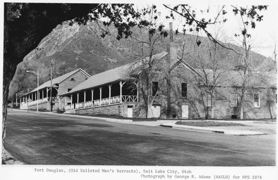
Old Enlisted Men’s Barracks (buildings 19, 20, 31, 32). Buildings 31 and 32 are almost identical. These one-story, red sandstone structures were erected on the southern edge of the parade ground between 1874 and 1876, They are U-shaped and gable roofed. Initially a railless frame veranda on brick piers extended approximately 105 feet across the front facade of each building, but early in this century, the Army replaced the old verandas with new ones featuring sandstone foundations, concrete floors, and railings. Of particular note are the windows, all of which are six-over-six sash with smooth stone sills and lintels. Both structures stand vacant but are being preserved, and building 31 has been selected to house the post museum. A similar pair of barracks stands on the northern edge of the parade ground. Having been converted into modern officers’ quarters, buildings 19 and 20 no longer have verandas, though. A gabled portico supported by four Doric columns has been added to the entrance of building 20, which is the residence of the post commander.
Oil House (building 39). This single-story, rectangular-shaped red sandstone structure was built in 1876 for use as an oil warehouse. It has a gable roof and measures about 30 by 20 feet. There are two rear and two front shuttered windows and a centrally located front door. All openings are topped by a segmental brick arch.
Old Commanding Officer’s Residence (building 55). Sometimes referred to as “Connor’s Home,” this white, stuccoed adobe structure with frame addition is believed to have been the residence of Gen. Patrick E. Connor during part of his tenure as post commander. Although the one-story, L-shaped dwelling has been altered considerably, it resembles houses shown in an 1868 Fort Douglas photograph published in the Utah Historical Quarterly, XXXIII (pages 326-327). Two interior chimneys pierce the gable roof, and a shed porch shelters the front entrance.
Chapel (building S48). Erected in 1884, the chapel is a one-story, rectangular-shaped, frame structure with a gable roof. Front entrance is through a square tower at the northeast corner of the building. A belfry, steeple, and Celtic cross crown the tower. Tan asbestos shingles cover the exterior walls, while four lancet windows grace both the north and south sides. A centrally placed tracery window adorns the front facade. The structure is in good condition and still in use.
Frame Officers Duplexes (buildings 2, 16, 17). These 1 1/2-story, frame structures were erected in 1884 on the same basic plan and with the same kind of bargeboard trim as the sandstone dwellings on Officers Circle. Unlike their masonry counterparts, these residences have no 20th-century rear additions. Recently, however, white aluminum was placed over the original yellow-painted weatherboarding.
Stable (building 101). Erected in 1886, this gable-roofed, red sandstone structure measures 37 feet wide and 303 feet long. Currently it is used as a warehouse, and an enclosed 14-foot-wide shed has been built along each side for additional storage space. The stalls have been removed too, but the original stable walls are intact, as are the hayloft and some offices.
Bakery (building 28). Records in the post engineer’s office show that the bakery was erected in 1884, but the design and materials correspond to the 1875-76 construction period. The one-story, rectangular-shaped structure is built of coursed red sandstone and has a gable roof.
Old Bachelor Officers’ Quarters (building 5). This elegant two-story, L-shaped, red brick structure was constructed around the turn of the century. It has a hip roof, seven interior chimneys, a sandstone foundation, a stone water table, and a bracket-supported wooden cornice. Extending across the front facade is a two-tiered, balustraded veranda with wooden Doric columns and three short stairs that provide access from the street. The southernmost stair is sheltered by a two-story, pedimented portico, and entrance to this part of the building is through a double door flanked by side and transom lights. The interior has been altered to accomodate the Marine Corps Recruiting Service.
Enlisted Men’s Barracks (buildings 102, 103, 104, 105, 106, 107, 108).These two-story, U-shaped structures were built between 1904 and 1910 as part of a major post improvement program. Situated around Soldiers’ Circle, they are constructed of red brick, and their gable roofs are covered with slate shingles. The original porches have been removed from the front of the buildings, but they have undergone no other significant external changes. Interiors have been altered for educational and administrative use.
New Officers Quarters (buildings 21, 22, 23, 24, 25). These two-story, gable-roofed cottages consist of a central block with one wing. Built of red brick in 1931, they are trimmed in white-painted wood, and each structure has a flat-roofed, single-bay, front entrance portico supported by two Doric columns and two pilasters. The quarters face the west corner of the parade ground.
Within the boundary there are several other structures that have not been described. Only five were constructed after 1931, though, and generally these are stylistically compatible with the other 20th-century buildings.
Boundary. Beginning at the intersection of Hempstead Road and the access street behind the buildings fronting onto Soldiers 1 Circle, a line extending along the curving service road to Fort Douglas Boulevard; thence northwestward along Fort Douglas Boulevard to the service road behind the structures fronting onto Officers Circle; thence northeastward along that service road to a point immediately to the rear of building 14; thence due southeast to the old oil house, building 39, around the structure, and back to the Officers’ Circle road; thence northward along the service road to a point immediately to the rear of building 13; thence northeastward across Connor Road and around the old commanding officer’s residence, building 55; thence northeastward along Connor road to Vollum Street; thence southwestward along Vollum Street to the service road behind the structures fronting onto Fort Douglas Boulevard; thence northwestward along the service road to the military reservation boundary; thence southwestward to Fort Douglas Boulevard; thence southeastward along the boulevard and the reservation boundary to the rear of the officer’s club; thence southeastward to the service road behind De Tobriand and Chase Streets and along that access route to Wasatch Drive; thence southward along the military reservation boundary to the starting point at Hempstead Road.
History
Led by Brigham Young, members of the Church of Jesus Christ of Latter-Day Saints began settling in Salt Lake Valley in 1847. They formed a theocratic government and within a few years turned much of the Great Basin into green farmland. In 1850 Congress designated the area Utah Territory, but sharp disagreement arose between the Mormons and their newly appointed Federal officials. Opposing all measures that promised to weaken their institutions, the Saints exerted complete control over Indian affairs and empowered the territory’s probate courts to hear cases tried ordinarily before U.S. tribunals.
Against this background of noncooperation with Federal authorities, the Mormons announced in 1852 that they believed in and practiced the doctrine of plural wives. For a time this belief received little notice outside Utah. Gradually, however, other Americans became aware of it, and a public outcry ensued. In 1857, with eastern protests against polygamy growing louder and the struggle for judicial supremacy in Utah worsening, President James Buchanan decided to send 2,500 U.S. troops to the territory to remind the Saints that they remained under American rule. After moving hundreds of wagonloads of supplies halfway across the continent and surviving a number of Mormon harassment raids, the expedition crossed the Wasatch Mountains and entered Salt Lake Valley in midsummer of 1858. At once the soldiers began constructing Camp Floyd at a hastily selected site midway between Provo and Salt Lake City, while Gov. Alfred W. Gumming tried to bring new direction to the territorial government.
0000Early in 1861 the more pressing problem of Southern secession forced the War Department to withdraw its occupation forces from Utah for utilization elsewhere. President Abraham Lincoln’s administration remained uneasy about Mormon intentions, though, and felt particular concern about the possibility of Indian attacks closing the now vulnerable overland communication and transportation routes. Accordingly, the War Department ordered Gen. George Wright, commander of the Department of the Pacific, to safeguard telegraph lines, mail routes, and emigrant trails in Utah, Nevada, and California. In mid-1862 Wright sent Col. Patrick E. Connor to Utah with approximately 750 California Volunteers. The command reached Salt Lake City early in September, and after reconnoitering the surrounding countryside, Connor situated his troops on a rise in the Wasatch foothills only a few miles east of the Mormon capital. In October the new post was officially christened Camp Douglas in honor of Senator Stephen A. Douglas.
Having arrived late in the year, the Volunteers hastened to erect temporary winter quarters. These consisted of tent-covered dugouts for enlisted men and log-and-adobe-covered dugouts for the officers. The following spring the soldiers built more permanent quarters, mostly of frame construction. Among these were 11 barracks, 8 officers’ residences, 12 dwellings for married soldiers, and a hospital.
Connor did not wait until spring to direct his attention to Indian affairs, however. Knowing that bands of Shoshones, Bannocks, and Utes had been harassing the Overland Mail and tormenting miners for years in northern Utah and southern Idaho, he set out after the militant Shoshoni leader Bear Hunter in January 1863 and found him and his party encamped in a ravine near Bear River 140 miles north of Salt Lake City. Shortly after daybreak on January 27 the soldiers attacked. When the fighting ended in midmorning, 224 Shoshoni men, women, and children lay dead on the battlefield. The War Department considered the bloody episode a signal achievement and promoted Connor to brigadier general. During the ensuing months troops from Camp Douglas engaged in numerous lesser encounters with Utes, Bannocks, and other bands, and in the fall Connor and Superintendent of Indian Affairs James D. Doty made peace with almost all the Indians in the territory. Relative calm prevailed until the Black Hawk War of 1865, after which less significant outbreaks occurred periodically through the 1880’s.
With the Indian problem temporarily under control, General Connor turned next to the Mormons. He disliked them immensely, and although he had no proof, he was convinced that they had encouraged the Indian depredations. Furthermore, he became outraged at the high prices that his command had to pay for supplies purchased from the Saints. After his superiors ignored his suggestion that martial law be declared in Utah, Connor stumbled upon another way to combat what he regarded as the Mormon menace.
In September 1863 a group of Saints accidentally unearthed some silver ore while dragging logs in Bingham Canyon, where they shared a grazing area with several Camp Douglas Volunteer units. The Mormons took the ore to Connor, who had it assayed and directed the iinmediate formation of the Jordan Silver Mining Company and the West Mountain Quartz Mining District. These represented Utah’s first recorded mining claim and first formally organized mining district. Other discoveries followed, and Connor decided that the so-called Mormon problem could be solved if the territory’s mineral resources were properly exploited and Gentile miners encouraged to immigrate.
Toward that end the general sent military patrols throughout the territory in search of gold, silver, and lead. In addition, to publicize the soldiers’ numerous discoveries, he established a post newspaper, The Union Vedette. It was the first non-Mormon paper in the territory, and by 1864 it had become the first daily and had gained wide circulation both in Utah and in neighboring States and territories. Although Connor never realized his dream of submerging the Mormons in a sea of Gentiles, his newspaper continued in operation until November 1867, and ultimately he became known as the Father of Utah Mining.
When the Civil War ended, the War Department mustered nearly all the California Volunteers out of the service, and in 1866 the 18th Infantry moved into Camp Douglas. Early in the 1870’s, a resumption of Indian difficulties lent the post new importance, and in 1874 the Army undertook a reconstruction program there. During the next 2 years, the camp was almost completely rebuilt with red sandstone, and in 1878 it was redesignated Fort Douglas.
With the extension of railroads into the Mountain West in the 1880’s, the Army began to concentrate its forces at a number of larger posts. Upon the recommendations of Gen. George Crook and Gen. Philip H. Sheridan, the War Department made Fort Douglas one of the principal military installations in the central Rockies. It absorbed the garrisons of Fort Hall in Idaho and Forts Thornburgh and Cameron in Utah, and in 1884 several frame structures were erected to house the additional personnel.
By this time life at Fort Douglas had become fairly routine, although during a series of Federal polygamy prosecutions in 1888, some of the troops were stationed in downtown Salt Lake City to maintain order. In 1898 the War Department withdrew most of the garrison for service in the Spanish-American War, but the post census soared again when the 12th Infantry was assigned there in 1902. Several barracks buildings, a post exchange, and a hospital were erected to accommodate the new residents.
World War I brought another flurry of activity. In the fall of 1916 the Government opened one of its national physical preparedness camps at Fort Douglas, and in 1917 some 4,000-5,000 recruits arrived there for combat training. Perhaps the most distinguished wartime inhabitants of the post were 331 German prisoners who were incarcerated in a frame barracks surrounded by two barbed wire fences. Various units occupied Fort Douglas between the World Wars, and in the 1930’s the post served as a district headquarters and training camp for the Civilian Conservation Corps. None of the temporary buildings associated with these various activities survive. In 1942, soon after the Japanese attack on Pearl Harbor, the Army’s regional headquarters or 9th Service Command moved to Fort Douglas and remained until 1946. Since then the post has housed Army finance offices and a number of reserve groups.
Fort Douglas has a rich history that extends far beyond its stone buildings, embodying a narrative of constant change and adaptation. The Post has evolved significantly over the years in response to various social, military, and economic conditions, reflected in its architectural evolution. This history can be segmented into seven main periods, illustrating the dynamic nature of Fort Douglas and its community.
The establishment of Fort Douglas began in 1862, marked by a sense of impermanence as the first troops utilized makeshift structures such as dugouts and tents. Initial constructions were basic, made from local materials like adobe and logs, indicating the belief that the Army’s presence in the Salt Lake Valley would be temporary. However, the only surviving building from this early phase is the Post Commander’s Quarters, symbolizing the Post’s modest beginnings.
By the late 19th century, under the leadership of Colonel John Gibbon, Fort Douglas transitioned into a phase of permanence (1869-1891). This period saw significant renovations and the introduction of Gothic Revival architecture, with many buildings constructed from locally sourced sandstone. The Post expanded further in the 1880s to accommodate a growing military presence, solidifying its role in the region.
From 1891 to 1922, Fort Douglas underwent another transformation, aligning with the professionalization of the Army. The end of the Indian Wars necessitated improvements in living conditions to attract skilled recruits. This era brought modern amenities like indoor plumbing and electric lighting, along with new structures such as a Post Exchange and various recreational facilities, enhancing the quality of life for soldiers stationed there.
The years from 1922 to 1940 marked a “Golden Age” for Fort Douglas, driven by the arrival of the 38th Infantry Regiment. A nationwide building program in 1927 led to further upgrades, including expanded housing and recreational facilities. During the Great Depression, the Post significantly contributed to the local economy, demonstrating its importance not just as a military installation but as a community asset.
World War II prompted a surge in activity at Fort Douglas, particularly after the attack on Pearl Harbor in 1941. The construction of standardized wooden buildings catered to wartime needs, emphasizing speed and efficiency. Despite being labeled “temporary,” these structures were built with quality in mind, serving a vital role during the war and beyond.
Post-war, Fort Douglas experienced a contraction period, with many functions and personnel relocating elsewhere. The base’s size was reduced, and various buildings were repurposed or transferred to other entities. This phase saw the Post adapt to new roles, including serving as a support unit for the Army Reserve.
In recent decades, the site played a role in the 2002 Winter Olympics, housing athletes and further integrating its rich history into contemporary use. Since that time, the University of Utah has taken steps to revitalize Fort Douglas, blending new student housing with the historical environment. This initiative has aimed to restore historic buildings while maintaining their unique character, preserving the legacy of Fort Douglas as both a military and community hub.
Fifteen miles west at Abraham is the location of the bleak desert site of a concentration camp, one of ten in Western America, in which 110,000 persons of Japanese ancestry were interned against their will during World War II. They were the victims of wartime hysteria, racial animosity, and economic opportunism on the West Coast.
Confined behind barbed wire fence and guarded by armed sentries ad held for no justifiable reason, the internees, two-thirds of whom were American citizens, and the majority of whom were women and children, not only endured the bitter physical discomforts of the desert heat and cold, but sustained a shocking affront to their sense of justice and fair play and human dignity. May this grim episode of basic American principles gone astray remind us to work for understanding and goodwill and justice in an enlightened America today.
The former residents of Topaz remember with grateful appreciation the friendliness and understanding with which the people of Delta received us during the period of our trial and despair.
This historic marker is located at the city park in Delta, Utah