This marker honors the first settlers of Providence, who camped near here early in May 1859, and those who followed in the years 1860,1861,1862. Included in the groups who pioneered this section are the following families: Alder, Bowen, Busenbark, Baer, Campbell, Clifford, Clark, Cranney, Dee, Durfey, Fuhriman, Flemming, Fife, Gates, Gassman, Greenback, Hafter, Hansen, Harmon, Hoth, Hug, Hall, Kresie, Lau, Low, Lane, Loosle, Maddison, Sperry, Sueifel, Theurer, Traber, VanLouevan, Williams, Wright, Zollinger.
This historic marker was erected June 7, 1947 by the Utah Pioneer Trails and Landmarks Association and is #110 in the series, their markers were later adopted by the Sons of Utah Pioneers. It is located at the Providence Church at 10 South Main Street in Providence, Utah
This cabin, built about 1841 by Miles Goodyear, as far as known the first permanent house built in Utah, stood near the junction of the Ogden and Weber Rivers. In 1848 it was sold to Captain James Brown of the Mormon Battalion with a Spanish land grant covering all of Weber County. It was preserved by Minerva Stone Shaw and by her presented to the Daughters of the Utah Pioneers, Weber County Chapter, who placed it on its present site.
This is Utah Pioneers Trails and Landmarks Association historic marker #41, later adopted by the Sons of Utah Pioneers. Erected July 24, 1934 and located at the Weber County Daughters of Utah Pioneers Museum at 2104 Lincoln Avenue in Ogden, Utah
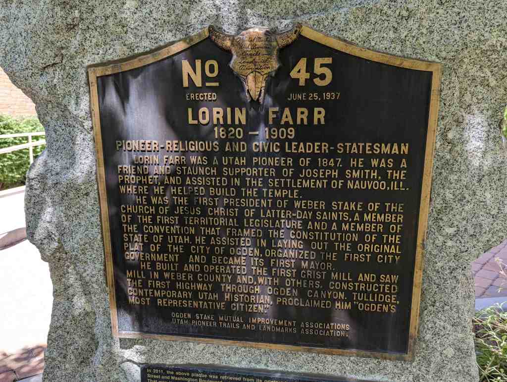
Lorin Farr 1820-1909 Pioneer-Religious and Civic Leader-Statesman
Lorin Farr was a Utah pioneer of 1847. He was a friend and staunch supporter of Joseph Smith, the Prophet, and assisted in the settlement of Nauvoo, Ill. Where he helped build the temple.
He was the first president of Weber Stake of the Church of Jesus Christ of Latter-day Saints, a member of the first Territorial Legislature and a member of the the convention that framed the constitution of the State of Utah. He assisted in laying out the original plat of the city of Ogden, organized the first city government and became its first mayor.
He build and operated the first grist mill and saw mill in Weber County and, with others, constructed the first highway through Ogden Canyon. Tullidge, contemporary Utah historian, proclaimed him “Ogden’s most representative citizen.”
This is Utah Pioneers Trails and Landmarks Association historic marker #45, later adopted by the Sons of Utah Pioneers (#177 in that series). Erected June 25, 1937 and located at the Weber County Daughters of Utah Pioneers Museum at 2104 Lincoln Avenue in Ogden, Utah
In 2011, the above plaque was retrieved from its original location at the corner of 21st Street and Washington Boulevard, when the structure it was mounted on was demolished. That was the location of one of Lorin Farr’s early homes. The Farr descendants and the Ogden Pioneer Chapter of the Sons of Utah Pioneers remounted it here in 2013, with appreciation to the Daughters of Utah Pioneers for allowing its relocation to this site.
Ellen (Nellie) Purcell was born November 6, 1846 in Tintwhistle, England. At 9 she, with her parents and sister Margaret (Maggie), 14, began the trek from Iowa to Salt Lake Valley in 1856 with the Edward Martin Handcart Company.
Early snows overtook the company, both Nellie’s parents died on the trail. Nellie’s feet were frozen.
On arrival in Salt Lake Valley, she was strapped to a board. No anesthetics were available. Both her legs were amputated just below the knee with a butcher’s knife and carpenter’s saw.
For the rest of her life she moved about on the painful stubs of her legs.
At 24 in Cedar City she became the plural wife of William Unthank. His income was small.
Beginning as a wife in a one-room log house with a dirt floor, she kept her home spotless. Nellie took in washing, she knitted stockings to sell. She gave birth to 6 children. Her Bishop and Relief Society occasionally brought food to her family. To even the score, once a year she and her children cleaned the meeting house throughout.
Nellie died at 68 in Cedar City — A noble representative of the rank and file of Mormon Pioneers.
This marker #38 of the historic markers by the Sons of Utah Pioneers, located on SUU Campus at 400 West 200 South in Cedar City, Utah.
The Lincoln Highway America’s First Coast-to-Coast Automobile Highway
The Lincoln Highway was established in 1913 when a group of businessmen involved in the automobile industry decided to sponsor and promote a transcontinental highway for automobile traffic.
They organized the Lincoln Highway Association and dedicated their proposed highway to the memory of President Abraham Lincoln. On September 10, 1913, the route of the highway was announced, and the general public was invited to become members of the association. Contributions to help finance the improvement of the highway were solicited from businesses and private citizens.
The route that was chosen for the Lincoln Highway went from New York City to San Francisco, following the straightest line that was possible. In the beginning, the route was laid out along already existing roads, but an important part of the plan was that these roads would be improved and the route shortened wherever possible.
A major goal of the Lincoln Highway Association was to persuade local, state, and the federal government to get involved in the improvement and construction of automobile roads and highways. The Association wanted the Lincoln Highway to be a model for the building of roads throughout the United States. By 1928 they felt that for the most part they had achieved their goals, and it was decided to dissolve the association. But the Lincoln Highway lives on. Although most of the original highway has been replaced by modern roads such as US Highway 30, US 40, and Interstate 80, many sections of the Lincoln Highway are still being used today.
In western Utah, the original 1913 route of the Lincoln Highway came through the city of Grantsville, then continued west through Skull Valley, Fish Springs, Callao, and Ibapah. In 1919, construction projects at Johnson Pass in the Stansbury Mountains and on the mud flats west of Granite Peak were completed, and the route was changed to go through Tooele and Gold Hill, which shortened the route by about 50 miles. Grantsville was dropped from the route. But another change came in 1927. For several years, the state of Utah had been working on a road across the Great Salt Lake Desert to Wendover, a small town on the Nevada border. This project was completed in 1925, and two years later, the Lincoln Highway Association made the decision to incorporate this new road into its official route. Grantsville was on the Lincoln Highway again.
This is Sons of Utah Pioneers historic marker #178, located at Lincoln Park, 550 West Clark Street in Grantsville, Utah
The Historic Dixie-Long Valley, Utah Pioneer Trail
Segments of the old Indian trails between St. George and Long Valley were used by Mormon pioneers to settle Long Valley in 1864 and for its resettlement in 1871 following Indian conflicts. The trail divided at the area of this marker, the Elephant Trail took a northeasterly route while the alternate Cottonwood Canyon-Sand Ridge Trail went more easterly before joining the Elephant Trail after it descended into Parunuweap Canyon/Long Valley. The desert trail, about 85 miles long, traversed deep sand, sandstone ledges and lava faults and was the primary transportation route, including mail and heavy freight, for half a century. It took four days for loaded wagons drawn by horse or ox teams to travel the distance.
This is #119 of the Sons of Utah Pioneers historic markers.
Major Irrigation Canals Constructed in Cache Valley
Before canals existed in Cache County, the agriculture was limited to dry farms and grazing. To pioneer settlements, water was not only the source of wealth, but of human existence. Construction of the Logan and Hyde Park canal (9) was started in 1860. Work on four more Logan River canals (8,10, 11, and 12) began in 1864. The highest canal (7) was begun in 1881.
Tools for canal construction included shovels, picks, spades, wooden plows, and go-devils. Go-devil ditchers were constructed of two large logs fastened together in the shape of an A, like a snow plow. Loaded with men and pulled with several yoke of oxen or teams of horses, this machine pushed the loose dirt to the sides to make the bank for the canal. It was estimated that up to 32 teams of horses were simultaneously working in the valley at one time. Blasting was used in the last Logan River canal (7) to provide channeling in rocky areas along the canyon walls. Concrete reinforcement was also required.
For the early canals, proper grade for water flow was established with homemade devices consisting of a horizontal 16 to 20 foot board with a vertical plumb bob hanging from a vertical frame in the middle and a vertical stake at each end. One stake was longer than the other so as to determine the amount of fall required to assure the water could flow downhill. On one canal the plumb bob level was accidentally reversed so the water was expected to run uphill and the project had to be resurveyed.
When cash was unavailable, canal workers were paid with deeds for acreages to be irrigated. Food and tents were provided as workers lived on the job. Bank loans could not always be repaid and one project went bankrupt and remained idle for seven years. Completed canals were often breached and maintenance was a continuing activity. Despite numerous difficulties, using homemade devices and working in close cooperation, the pioneers brought some 50,000 irrigated acres into production by 1880 and more than 90,000 acres by 1900. This represented 1,255 farms in 1880 and 2,506 in 1900. By 1900 there were 118 separate cooperative canal systems in the valley. Most of these early cooperatives never incorporated and in 1956 remained mutual companies managed by and belonging to the farmers they served.
This historic marker is #184 of the historic markers erected by the Sons of Utah Pioneers, it was erected in 2014 and is in Canyon Entrance Park in Logan, Utah.
Thirty feet east of this spot was built, in the winter of 1865-1866, under the leadership of Benget P. Woolfenstein, the first community center of the Logan Fifth Ward. Consisting of but one room, 16 by 20 feet. It served, nevertheless, as church building, amusement hall, and school house. William G. Cole being the first teacher.
At that early date, eager for religious, social, and educational growth, the ward united upon the project. Even boys of school age helped men with teams get the logs from Green Canyon. Others laid them into the building that rose. A humble symbol of the cooperative spirit of the Mormon Pioneer. – To commemorate that enterprise this monument was erected by the Scout Explorers, Troop 105, of the Logan Fifth Ward. John Q. Adams and Dan A. Swenson ward committee, Henry K. Aebischer troop leader. The Original key, affixed to a stone from the foundation of the old house, has been made part of this marker.
This historic marker was erected in 1935 by the Utah Pioneer Trails and Landmarks Association and is #63 in the series, their markers were later adopted by the Sons of Utah Pioneers. It is located at 480 North 400 East in Logan, Utah.
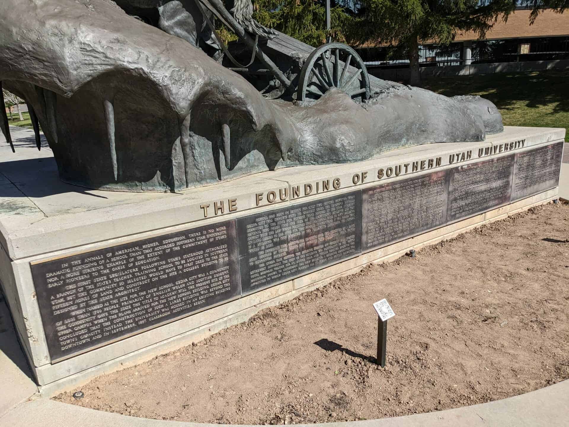
In the annals of American higher education, there is no more dramatic founding of a school than that accorded Southern Utah University, nor a more striking example of the extent of the commitment of Utah’s early pioneers to the cause of education.
The first State Legislature following Utah’s statehood authorized a branch of the state’s teacher training school to be located in Southern Utah, but the community so selected would have to first deed to the state 15 acres of land and construct on the site a college building to be designed by the state architect.
When named as the site of the new school, Cedar City was a community of less than 1500 people, primarily of English, Welch and the Scottish descent. The community gave the state the title to Academy Hill, plans arrived for the new school building, Cedar City concluded that the construction of such a large building was beyond the town’s capacity. Instead, the University was housed in an existing building downtown and in September 1897 classroom activities began.
School had been in session for only two months, however, when Cedar City was thrown into its greatest crisis. The teacher’s payrolls submitted to the state for payment were refused by the Utah Attorney General who ruled that size of the downtown building did not comply with the law which required that the school have its own building on land deeded to the state for that purpose. Furthermore, it was ruled that if a building was not erected by the following September, the school would be lost.
The immediate task, getting the teachers paid, was resolved by a bank loan secured by three Cedar City families who mortgaged their homes to guarantee payment.
The other task, getting the building erected on Academy Hill, proved extremely difficult. The cost of the building was equivalent to the town’s total business volume for an entire year and would require beating the mountain snows to construct the new building. A building committee was appointed to which Cedar City pledged all its public and private resources, the committee being forced to dip into both generously.
On January 5, 1898, a group of men, the first of a long line of townsmen to face the bitter winter weather of the mountains left Cedar City for a saw mill 35 miles away (near present day Brian Head). Their task was to cut logs necessary to supply the wood for the new building. That expedition, and the others that followed, worked in temperatures that dropped as low as 40 degrees below zero. To protect their legs from the biting winds they tied gunny sacks about their waists and legs.
The initial expedition, engulfed by a record snow storm, attempted to return to Cedar City and was forced to wade through snow drifts that sometimes were 15 feet high and 100 yards long. An old Sorrel horse, placed out at the vanguard of the party, is credited with having saved the expedition by walking into the drifts, pushing and straining against the snow, throwing himself into the drifts again and again until they gave way. Then he would pause for a rest, sitting down on his haunches the way a dog does, then get up and start again.
The mountain workers were divided into groups. Some cut logs, some were sawers, some planed logs into lumber, and others hauled the lumber from the mill. It took two and a half days to get a load of logs down from the mountain tops to Cedar City. When heavy snows kept provisions from reaching the working men, they subsisted on a diet of dried peaches. From January through July they kept up their labors.
The bricks for the building, over 250,000 of them, were made by a corps of people who remained in Cedar City, often putting in 12 to 14 hours a day on the project.
To purchase building materials that could not be made locally, cash was needed. Some people donated their stock in the Cedar City Co-op store while others offered their stock in the cooperative cattle company. One family gave the siding off their barn, another gave the lumber they had purchased to build a kitchen on their home. Still others gave prize lumber that had been saved for coffins.
When September 1890 arrived, the building was completed.
It contained a large chapel, a library, and reading room, a natural history museum, biological and physical laboratories, classrooms, and offices. It stands today at the end of the founders’ walkway, directly east of this monument. Its interior has been remodeled several times but the exterior walls are the original ones constructed in 1898.
That first building was literally torn from icy crags and molded by the hands of more than 100 men and women. The community of Cedar City had met its greatest test, and the University was given a heritage unmatched by any other educational institution in the United States.
The preserving of the University was achieved by people who would never attend it, indeed some of them never had the opportunity of attending any school. They were hardy, rough-spoken, courageous men and women, people of the type without whom the frontiers of the west could never have been conquered.
Pony Express – 1860-61 St. Joseph, Missouri – Sacramento, California Also Overland Stage & Freight Route 1858-1868
This monument was constructed by enrollees, U. S. Grazing Division, C. C. C. Camp 116, Company 2529 on August 23, 1940 and sponsored by the Utah Pioneer Trails and Landmarks Association (#91 of their monuments) it was later adopted by the Sons of Utah Pioneers (#237 of their monuments) and rededicated in 2017.