• About JacobBarlow.com
  • Cemeteries in Utah
  • D.U.P. Markers
  • Doors
  • Exploring Utah Email List
  • Geocaching
  • Historic Marker Map
  • Links
  • Movie/TV Show Filming Locations
  • Oldest in Utah
  • Other Travels
  • Photos Then and Now
  • S.U.P. Markers
  • U.P.T.L.A. Markers
  • Utah Cities and Places.
  • Utah Homes for Sale
  • Utah Treasure Hunt

JacobBarlow.com

~ Exploring with Jacob Barlow

JacobBarlow.com

Monthly Archives: January 2020

N.S. Nielson House

18 Saturday Jan 2020

Posted by Jacob Barlow in Uncategorized

≈ 2 Comments

Tags

Beaux-Arts, Historic Homes, Mt. Pleasant, NRHP, Queen Anne style, Sanpete County, Second Empire, utah

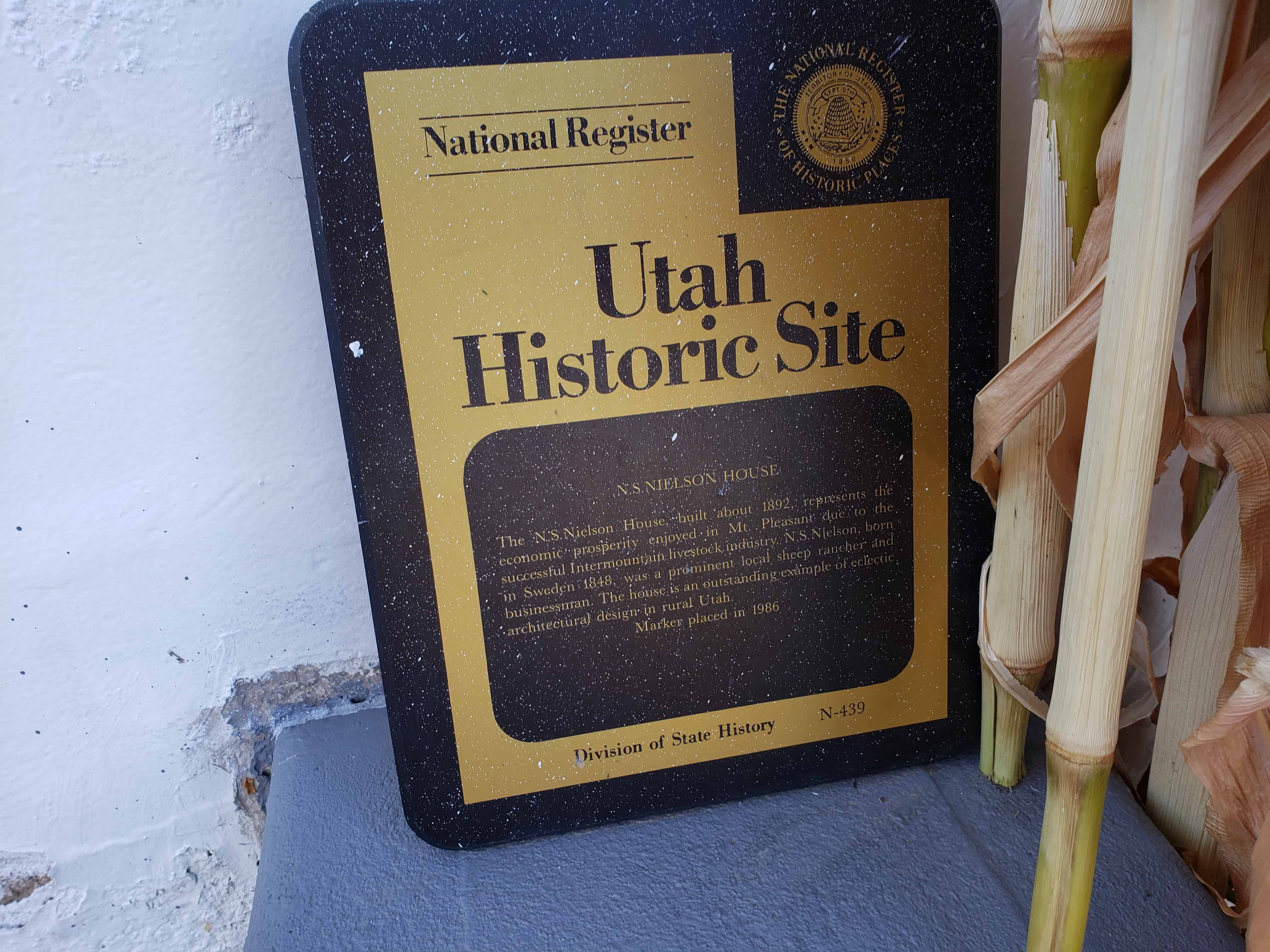
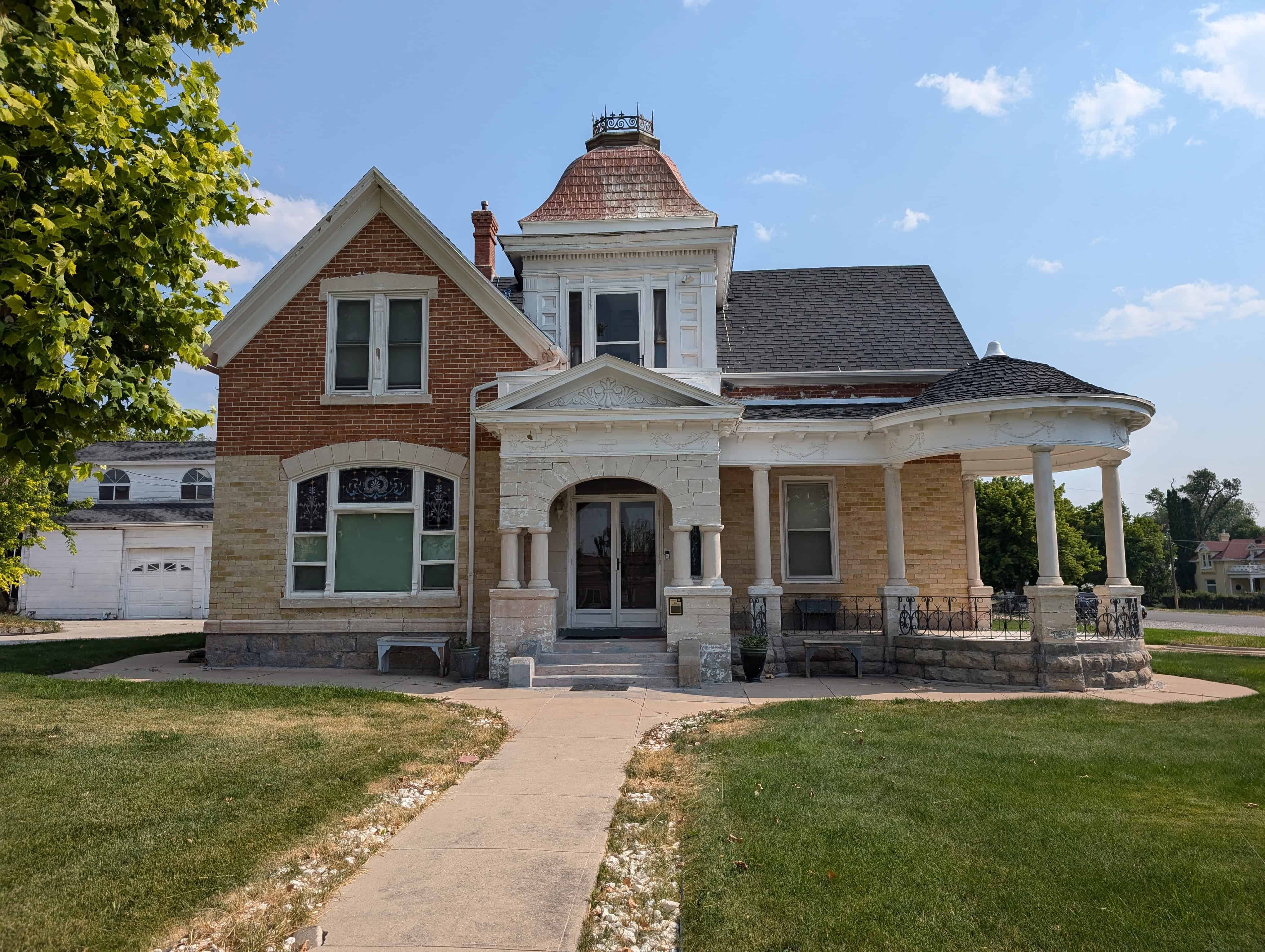
The N.S. Nielson House, built in 1890, represents the economic prosperity enjoyed in Mt. Pleasant due to the successful Intermountain livestock industry. N.S. Nielson, born in Sweden in 1848, was a prominent local sheep rancher and businessman. The house is an outstanding example of eclectic architectural design in rural Utah.

Related Posts:

  • Historic Homes in Mount Pleasant
  • Mount Pleasant, Utah
  • MtPleasantPioneer’s post about this home.
  • N.S. Neilson ~~~~ Pioneer of the Month

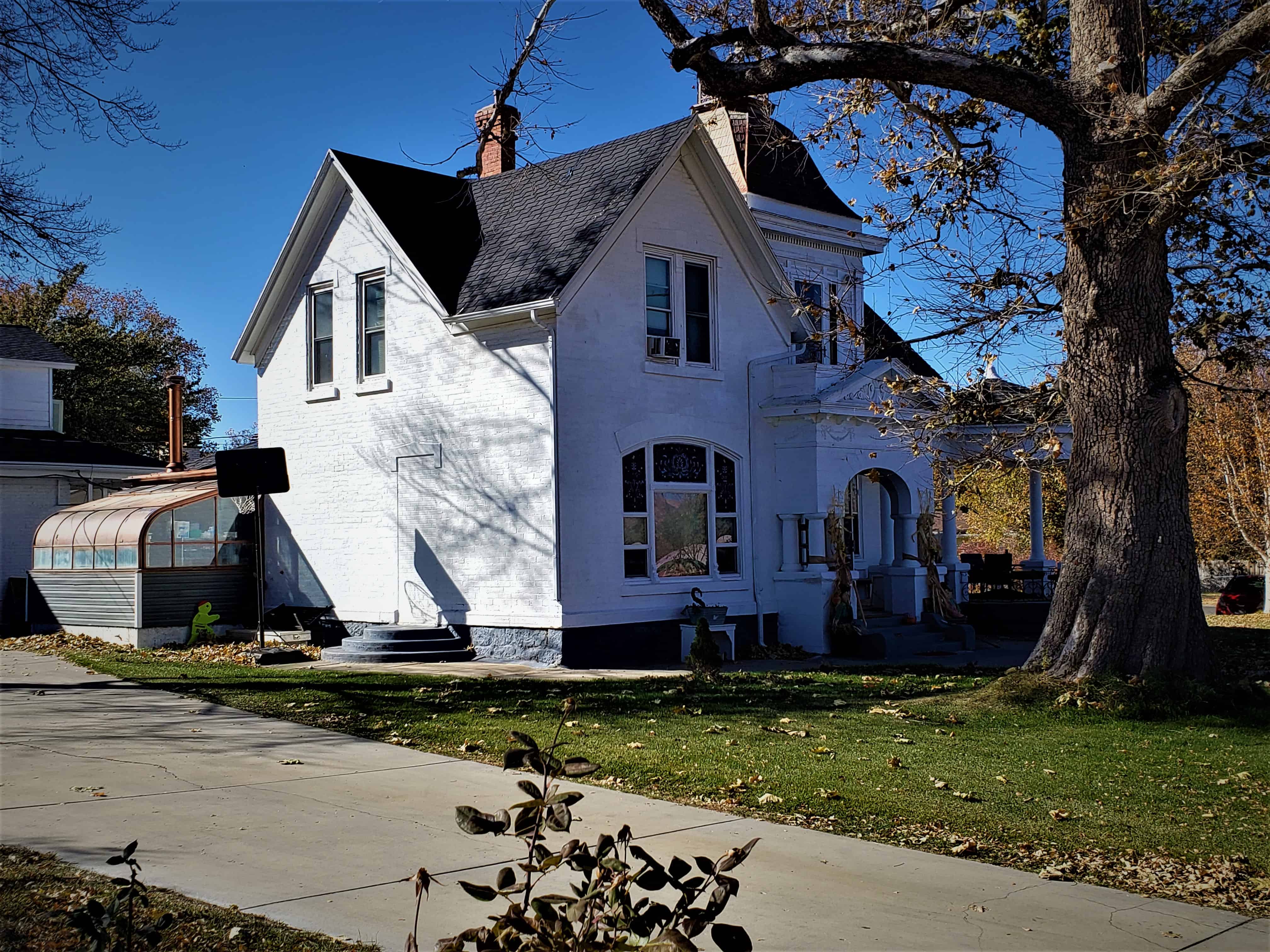
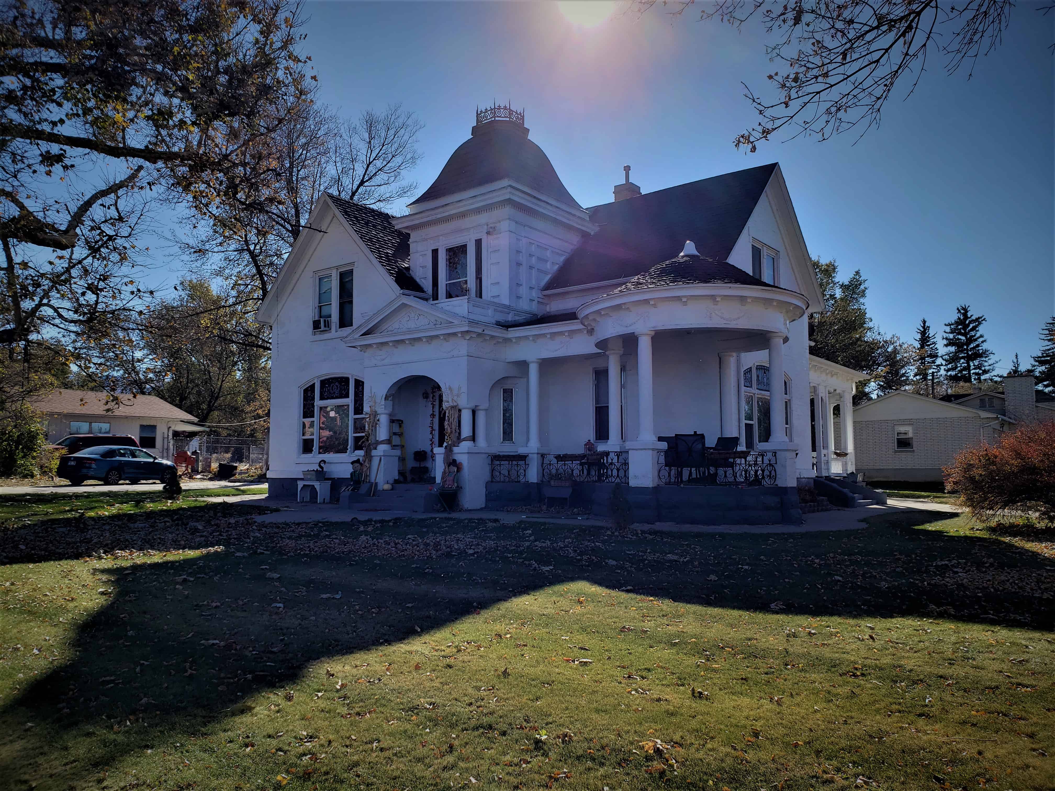
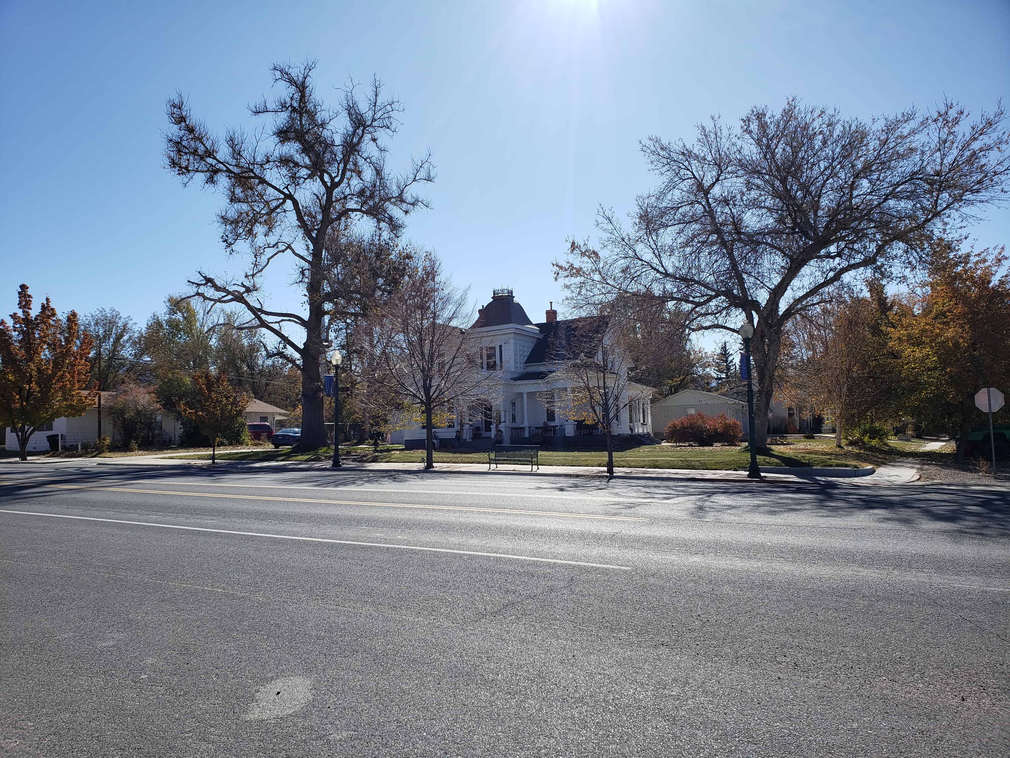
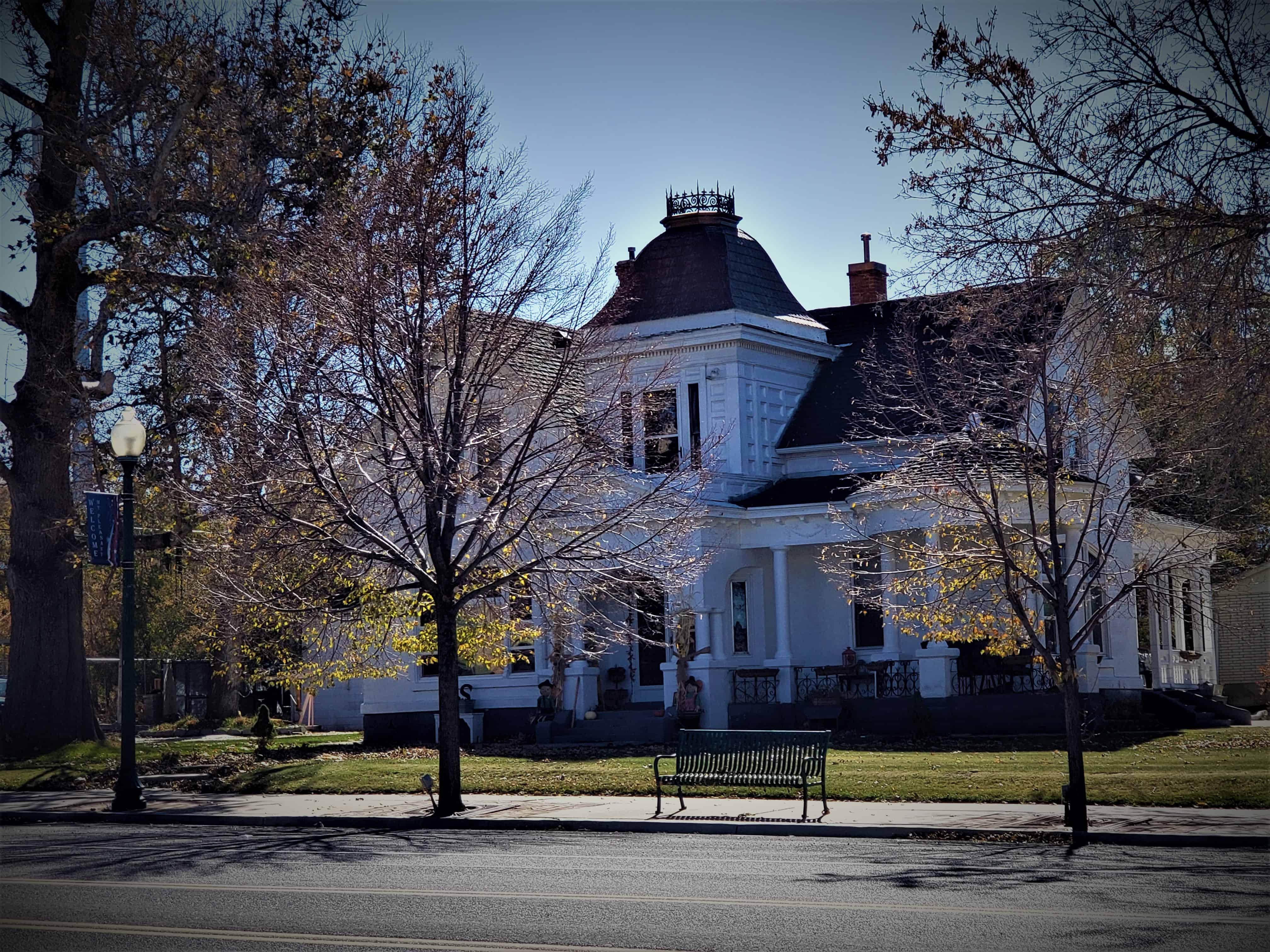
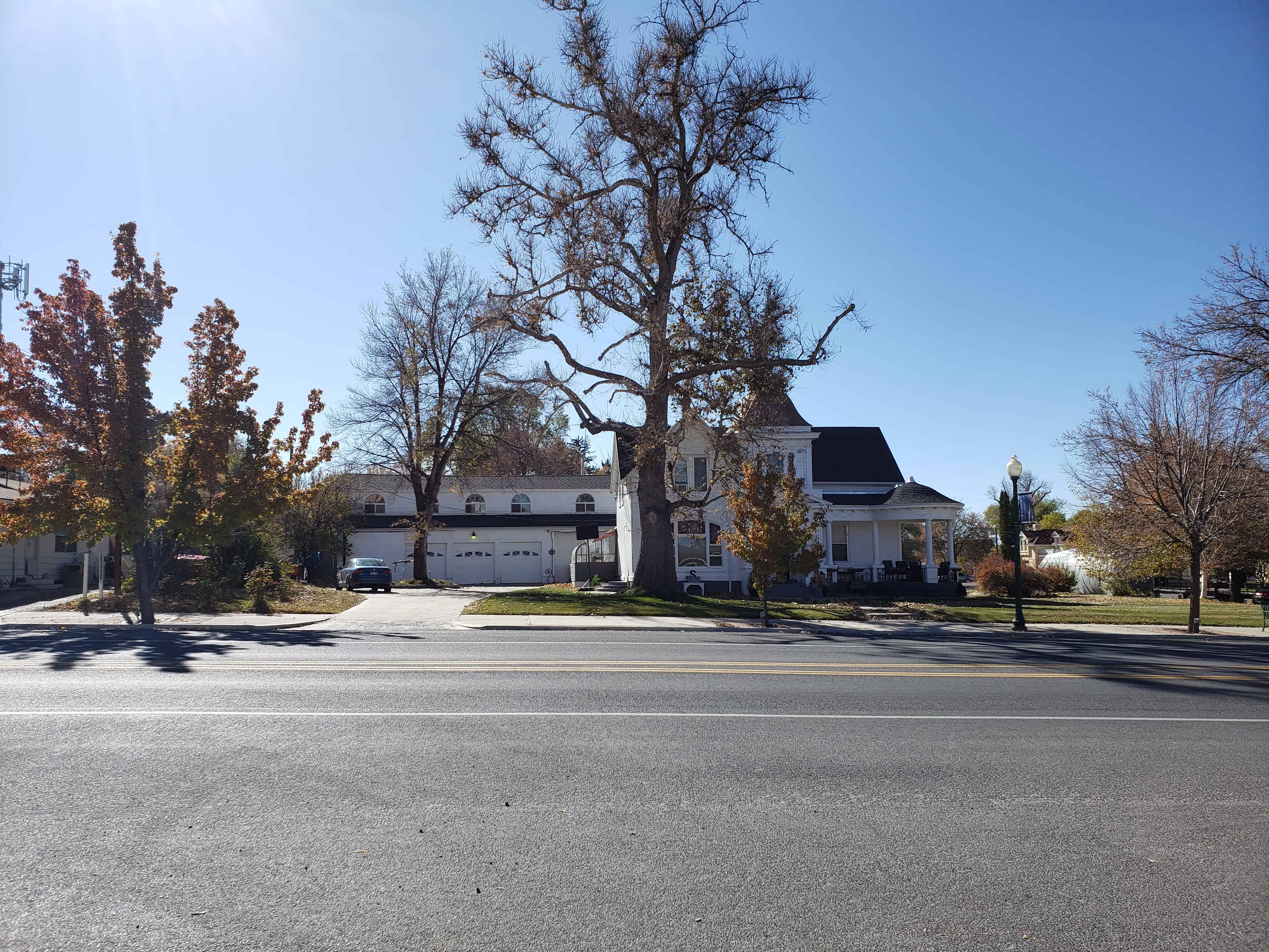
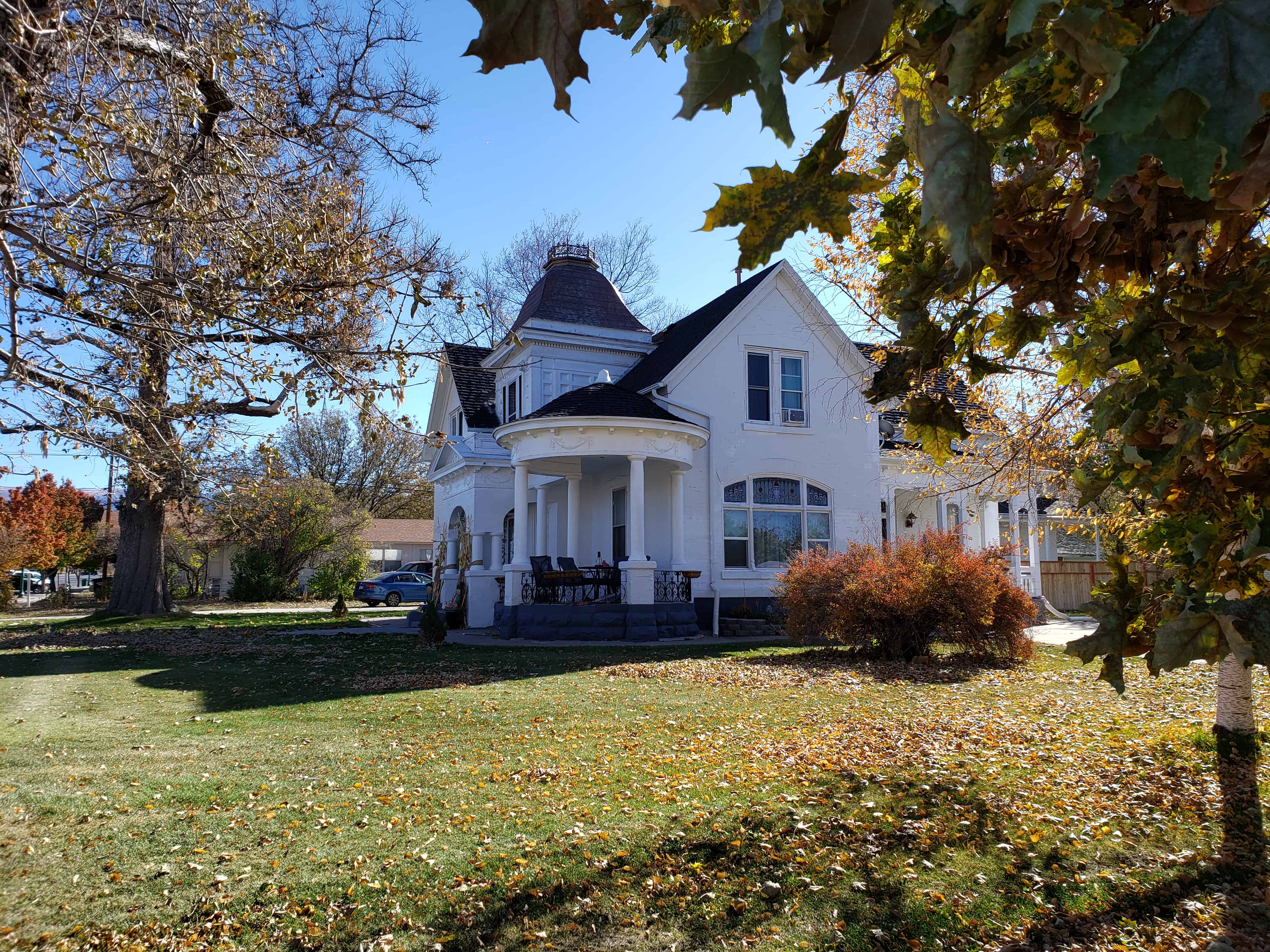
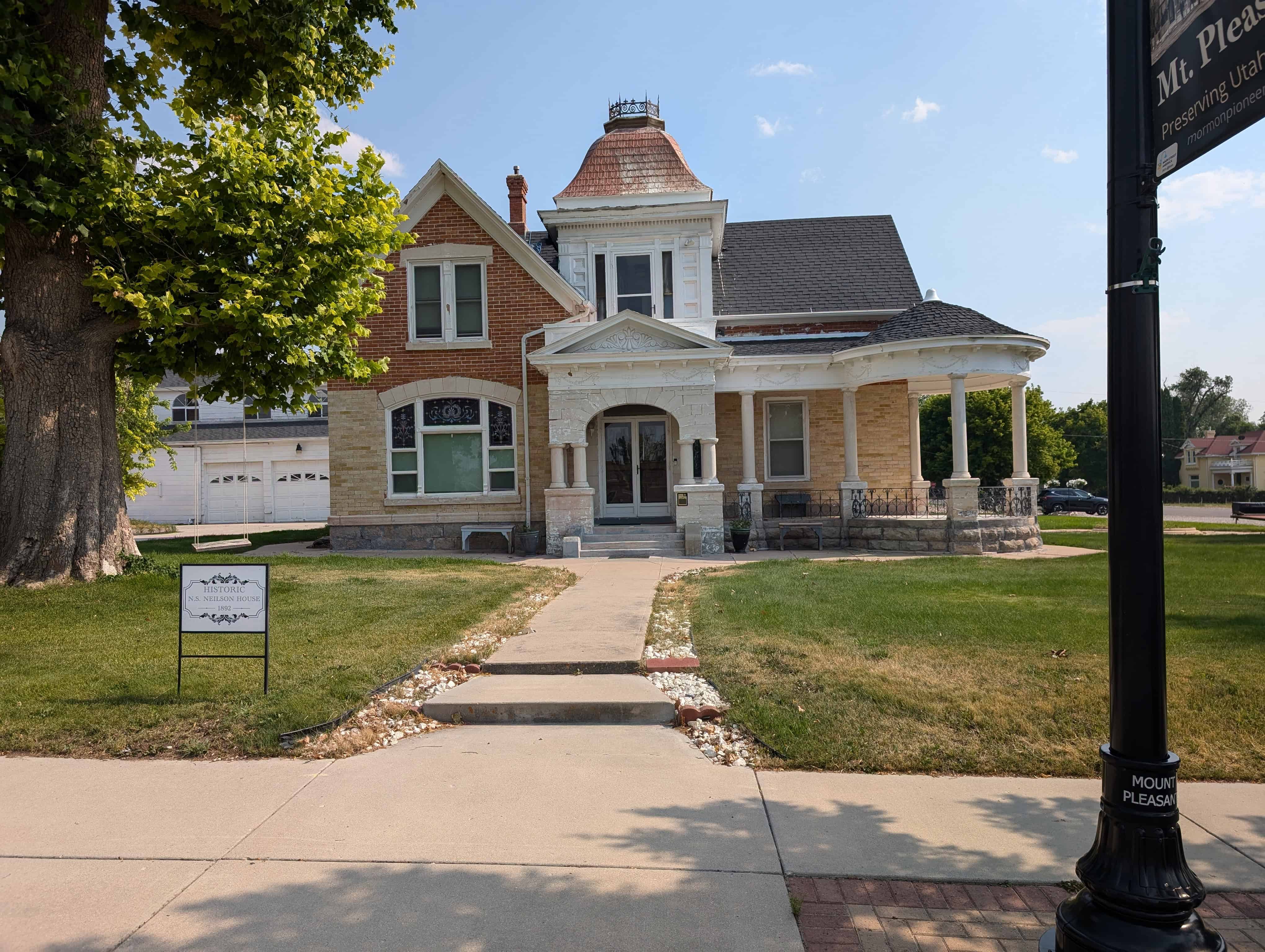
This elaborate, Queen Anne Style, one-and-one-half-story, brick home was built in 1890 by N.S. Neilson. It is a flamboyant example of Victorian massing and detailing as applied to a cross-wing house plan. The house was built in two stages; the first was completed about 1890 as a single cross-wing house; the second in 1892 creatively combined various new stylistic components such as the round portico, and square Mansard-roofed tower. There are five stained-glass windows, a variety of window and roof types, a formal main entry and classical ornament. This house has beautifully painted ceilings done by Carl Anderson who painted the Salt Lake City Play House.

N.S. Neilson was a Swedish immigrant; previously, he had been a serf in Sweden who worked for royalty. Neilson achieved the American dream after coming to Utah. He became a wool grower and prosperous local merchant, owning acreage and this fine house. Years later, this home was sold by Ruth James to Jay and Ethel L. Winkelman. The couple renovated the home and converted the carriage house to a four-car garage with a large recreation room on top. Later the home became a bed and breakfast called the Main Street Inn.(*)
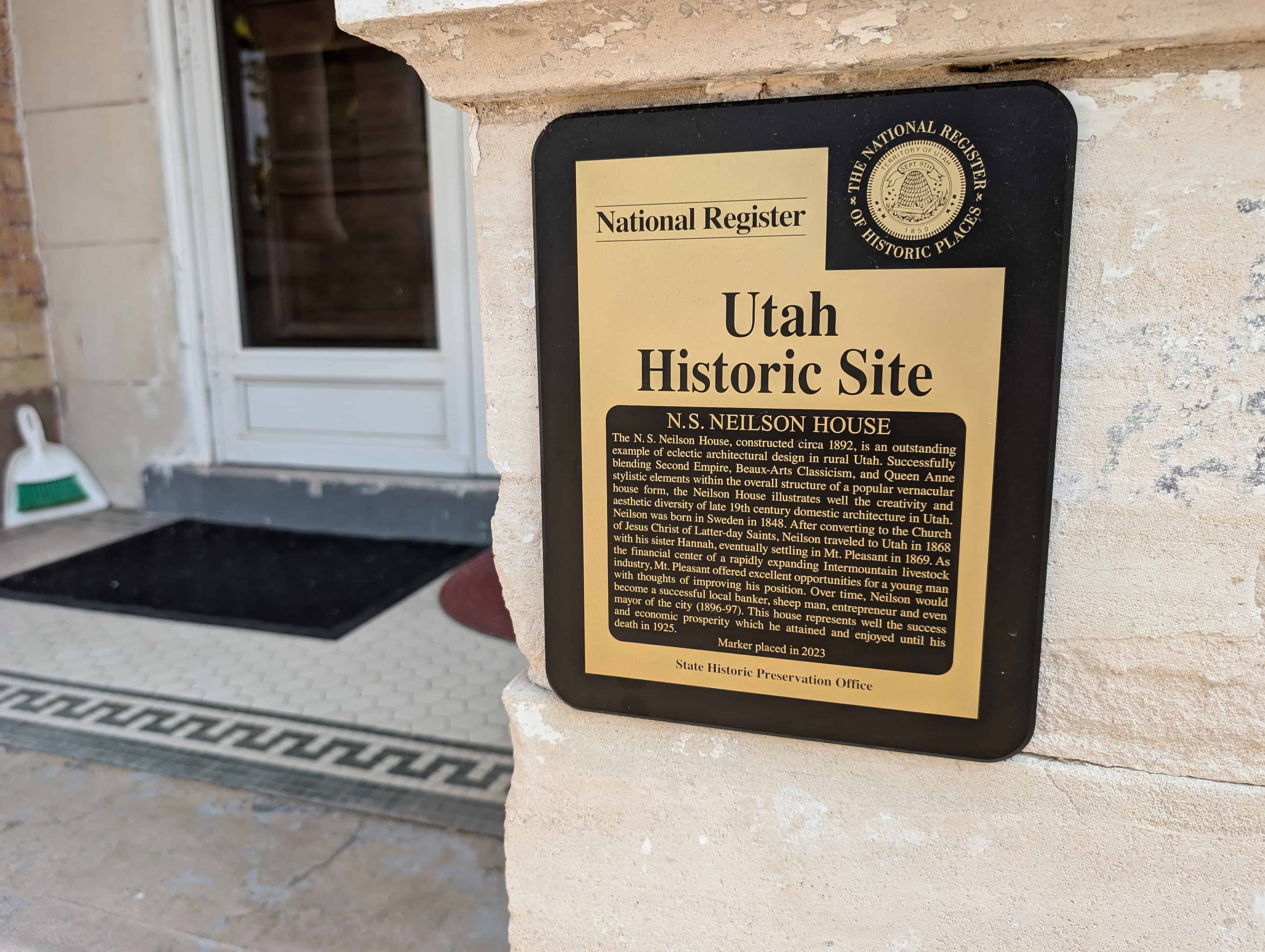
N.S. NEILSON HOUSE

The N. S. Neilson House, constructed circa 1892, is an outstanding example of eclectic architectural design in rural Utah. Successfully blending Second Empire, Beaux-Arts Classicism, and Queen Anne stylistic elements within the overall structure of a popular vernacular house form, the Neilson House illustrates well the creativity and aesthetic diversity of late 19th century domestic architecture in Utah. Neilson was born in Sweden in 1848. After converting to the Church of Jesus Christ of Latter-day Saints, Neilson traveled to Utah in 1868 with his sister Hannah, eventually settling in Mt. Pleasant in 1869. As the financial center of a rapidly expanding Intermountain livestock industry, Mt. Pleasant offered excellent opportunities for a young man with thoughts of improving his position. Over time, Neilson would become a successful local banker, sheep man, entrepreneur and even mayor of the city (1896-97). This house represents well the success and economic prosperity which he attained and enjoyed until his death in 1925.

Abandoned Water Park in Utah

18 Saturday Jan 2020

Posted by Jacob Barlow in Uncategorized

≈ 1 Comment

Tags

Abandoned, Salt Lake City, Salt Lake County, utah, Waterpark

Raging Waters, a large water park in Salt Lake City, Utah later became Seven Peaks Waterpark and then closed down. I stopped by to get some photos and video clips and document it before it fades away.

While I was there I noticed the grass had just been burned, I didn’t realize it was only two days prior until I got back and looked the park up online and saw this article. It turns out just a couple of weeks later there was a fire in the office (see this article) so I’m glad I went when I did.

Related Posts:

  • Salt Lake City, Utah
  • Seven Peaks Provo

Kinema Theatre

16 Thursday Jan 2020

Posted by Jacob Barlow in Uncategorized

≈ Leave a comment

Tags

Fires, Mt. Pleasant, Sanpete County, Theaters, utah

The Kinema was originally the Star Theatre in 1922. L.C. and Nada Lund ran it and when their son, L. Trux Lund took over he renamed it to the Kinema. It and the next door Queen City Dance Ballroom never recovered from the fire in February of 1990.

Related Posts:

  • Mt Pleasant, Utah
  • Source of images on this page.
  • Theaters in Utah

The theater was located where Wheeler’s Drive-In is, at about 130 S State St, in this photo that I saw on this page you can see the Relic Home on the left.

Plum Tree Plaza

16 Thursday Jan 2020

Posted by Jacob Barlow in Uncategorized

≈ Leave a comment

Tags

Provo, Retail Closure, Shopping Centers, utah county

Plum Tree Plaza in Provo, Utah – a shopping center with a movie theater, stores and restaurants that are slowly being demolished.

I stopped by to document what was left before it was too late to be able to look back onto it.

Related Posts:

  • Movies 8
  • Photos by Chris Sirrine

  • This is where Shopko was, taken 4/25/2021

Some other photos I took from the county property records:

Midway Tithing Office

16 Thursday Jan 2020

Posted by Jacob Barlow in Uncategorized

≈ 4 Comments

Tags

Midway, Tithing Offices, utah, Wasatch County

No longer with us, but I have found a couple of old renderings of the Tithing Office that was in Midway, Utah.

Movies 8

15 Wednesday Jan 2020

Posted by Jacob Barlow in Uncategorized

≈ 1 Comment

Tags

Abandoned, Movie Theaters, Provo, utah, utah county

Movies 8, located at 2424 North University Parkway, Provo, Utah opened in October 1988 and was a very popular spot for local families and students for over two decades and after slowing down for a few years finally closed after 29 years in March of 2017.

It was Cinemark’s test location for “dollar theaters” and at one point in 1992 was bringing in more revenue than any of the other 150+ Cinemark locations in the US.

Related Posts:

  • Plum Tree Plaza (the shopping center Movies 8 was part of)
  • Theaters in Utah

The following are from my friend Chris Sirrine’s album:

Christ the Fountainhead in Manti

15 Wednesday Jan 2020

Posted by Jacob Barlow in Uncategorized

≈ Leave a comment

Tags

Art, Knaphus, Manti, religious, Sanpete County, utah

Christ the Fountainhead is a bas-relief mural created by Torleif Knaphus.

The original was created for the exterior of the Cardston Alberta Temple.

This replica is found in the Manti Tabernacle, see others on this page.

Christ the Fountainhead

15 Wednesday Jan 2020

Posted by Jacob Barlow in Uncategorized

≈ 2 Comments

Christ the Fountainhead is a bas-relief mural created by Torleif Knaphus.

I have come across it several times and decided to start documenting each of them.

The original was created for the exterior of the Cardston Alberta Temple.

Replicas are found in the:

  • Provo Utah Temple (moved from demolished Monroe North Ward)
  • Tremonton 1st Ward
  • Meetinghouse in Rose Park
  • Meetinghouse in Las Vegas
  • Edgehill Ward Chapel (SLC)
  • Manti Tabernacle
  • Wells Ward (SLC)
  • Vats, Norway (in Torleif’s boyhood church)
  • Draper 2nd Ward Chapel (12883 S 1300 E) (Mural removed)

Gunnison Sage Grouse – Endangered

14 Tuesday Jan 2020

Posted by Jacob Barlow in Uncategorized

≈ Leave a comment

In downtown Provo, Utah I saw this mural on the side of a building:

Gunnison Sage Grouse – Endangered, due to habitat loss!

Pilot Peak

14 Tuesday Jan 2020

Posted by Jacob Barlow in Uncategorized

≈ Leave a comment

Tags

California Trail, Elko County, Nevada, Nevada Historic Markers

Pilot Peak

Nevada Historic Marker # 46

The high, symmetrically shaped mountain seen rising to the north is Pilot Peak, named by John C. Fremont on his expedition of 1845. Previously, the Bartleson-Bidwell party camped here in 1841. These emigrants had traveled one day and night across the Great Salt Lake Desert to find their first water here.

In the period 1845-1850, the peak was a famous landmark and symbol of hope and relief to the Reed-Donner Party and all other wagon train pioneers who traveled the 70-odd miles of deadly, thirst-and-heat-ridden steps across the Great Salt Lake Desert. This desert represented the worst section of the infamous Hastings Cutoff of the California Emigrant Trail.

Related Posts:

  • California Trail
  • John C. Fremont
  • Nevada Historic Markers

Other signs at this locations read:

Where Did the Lake Go?

Imagine Lake Bonneville some 10,000 years ago as a cast lake larger than the present Great Salt Lake. Its eastern boundary would be the Wasatch Mountains at Salt Lake City and its west boundary the Toano and Goshute Mountains to your left.

The last major glacial period in North America began about 23,000 years ago. During that time the water level of Lake Bonneville rose because of colder temperatures and a wetter climate. This freshwater lake was over 1,000 feet deep and covered 51,530 square miles – an area the size of Arkansas. If you were standing in this spot 15,000 years ago, you would be more than 500 feet underwater! Pilot Peak, the pyramid shaped mountain in front of you, was merely a small island surrounded by a freshwater lake teeming with fish.

About 15,500 years ago, water rushing through a break in a natural dam along Lake Bonneville’s northern shore dropped the lake level over 300 feet in just a few months! These raging floodwaters deepened the Snake River Canyon in Idaho. A warmer and drier climate over the next 5,000 years slowly caused the lake to shrink even further. Look carefully at the surrounding hills, especially east toward Wendover. You can still see the beach terraces left at the different high water marks as the lake receded. The Great Salt Lake is all that remains of this once vast lake.

Can Anything Survive Here?

Summer temperatures in this high desert can exceed 100 degrees; winter temperatures may fall below zero. Rain and snowfall total a mere six to eight inches per year. Only drought tolerant plants such as Indian ricegrass, shadscale, and greasewood can grow in the valley around you. The jackrabbit and pronghorn antelope are just two of the many animals that have adapted to living in this harsh environment.

This area wasn’t always a desert. Limber pine trees covered the Leppy Hills to the east from 10,000 to 12,000 years ago. As the climate became drier, pinyon pine and juniper trees replaced the limber pines at the lower elevations. Pinyon pines are relative newcomers to the surrounding mountains. They didn’t arrive until about 7,000 years ago. Today, limber pine and subalpine fir grow only at the higher, cooler and wetter elevations on Pilot Peak and nearby mountain ranges. Animals you might encounter in these forested areas include bighorn sheep, mule deer, elk and mountain lion.

In the fall thousands of raptors (birds of prey) migrate south along this valley. The Great Salt Lake Desert’s lack of food, water and lifting air currents form a migration barrier for these birds. Food, water and roosting sites are easy to find in the Toano and Goshute Ranges. Air rising over these mountains to the west provides the lift these birds need to soar. Conserving energy by soaring as much as possible during their long journey is a key to their survival.

Tough Traveling in the Desert

The Bidwell-Bartleson wagon train was the first emigrant party to see Pilot Peak in 1841. Four years later, Captain John C. Fremont also saw this distinctive landmark, but from the Cedar Range in Utah – some 75 miles away. He wanted to establish a trail from the Great Salt Lake to the existing California Trail along the Humboldt River. Fremont sent Kit Carson, a member of his expedition, ahead towards this peak to scout for a safe passage across the salt flats. Carson’s smoke signals from the mountain assured Fremont of a safe route and that the area contained food for the livestock and water for all. To recognize the importance of this mountain in crossing the desert, Fremont named it “Pilot Peak”.

In 1846 the Reed-Donner Party crossed this valley, following the Hastings Cutoff to the main California Trail. Crossing the salt flats just east of here was extremely difficult. Stock animals perished, wagons broke down, and the emigrants barely reached the life-saving springs at the base of Pilot Peak. This “short cut” slowed their progress and helped to set the stage for the disaster that lat 400 miles ahead of them in the Sierra Nevada Mountains.

As travelers today along Interstate 80, you’re following the same route as these early explorers and emigrants. On a good day, they worked hard to cover 10 to 15 miles through this harsh landscape. In the comfort of your air conditioned vehicle, you can cover in 10 minutes the distance it took these earlier travelers all day to cover!

← Older posts
Newer posts →

Follow Jacob

Follow Jacob

Blog Stats

  • 2,021,924 hits

Social and Other Links

BarlowLinks.com

Recent Posts

  • Dale’s Sinclair Service Station
  • 83 N Street
  • First Company of Pioneers into the Valley
  • Blue Base – The Stand Filming Location
  • 926 E South Temple

Archives


Loading Comments...