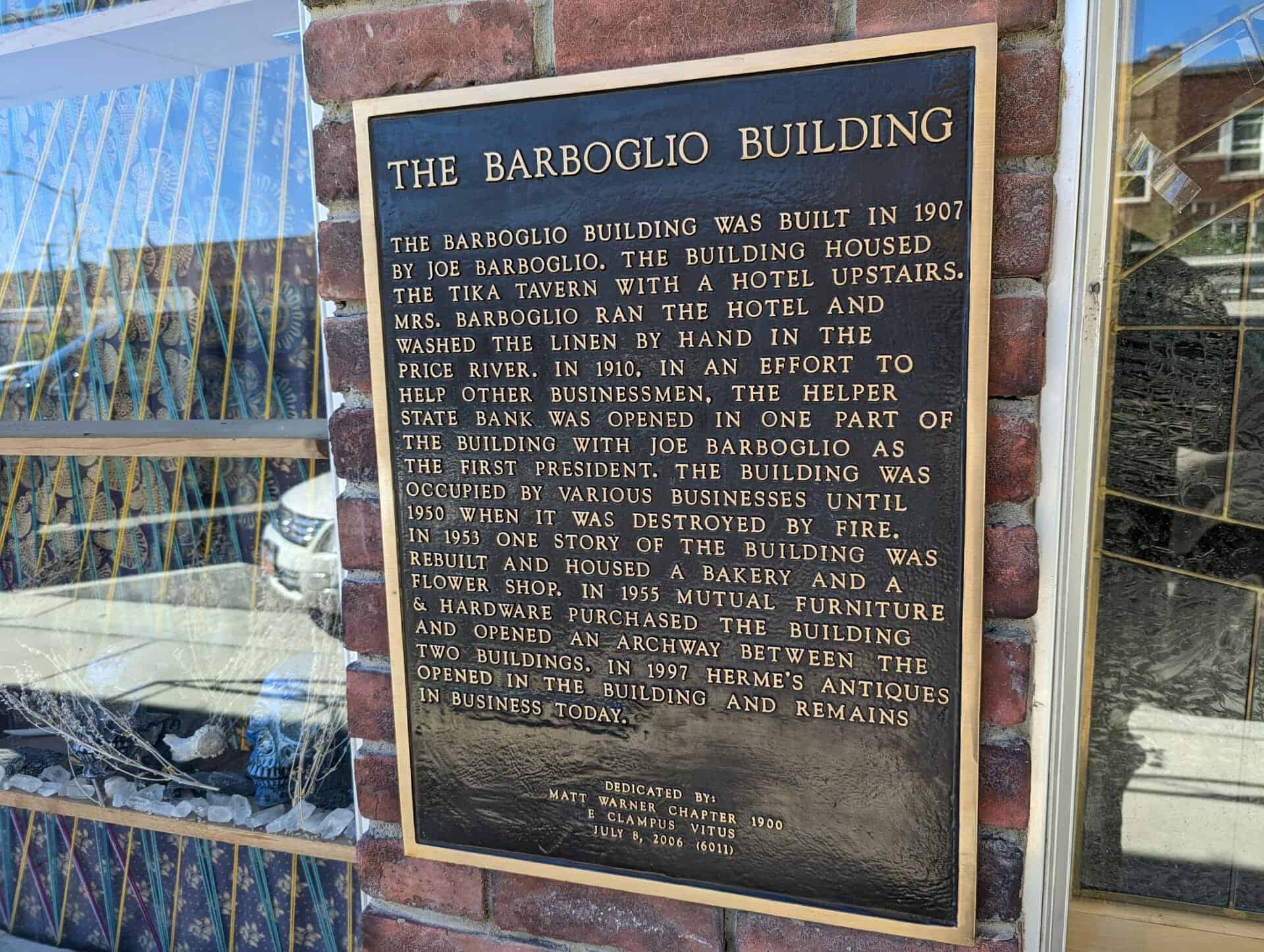
The Barboglio Building was built in 1907 by Joe Barboglio. The building housed the Tika Tavern with a hotel upstairs. Mrs. Barboglio ran the hotel and washed the linen by hand in the Price River. In 1910, in an effort to help other businessmen, the Helper State Bank was opened in one part of the building with Joe Barboglio as the first president. The building was occupied by various businesses until 1950 when it was destroyed by fire. In 1953 one story of the building was rebuilt and housed a bakery and a flower shop. In 1955 Mutual Furniture & Hardware purchased the building and opened an archway between the two buildings. In 1997 Herme’s Antiques opened in the building and remains in business today.
One story commercial building located on the site of the original Barboglio building known as the Tika Tavern. Present building houses an annex of the Mutual Furniture Company and bakery.
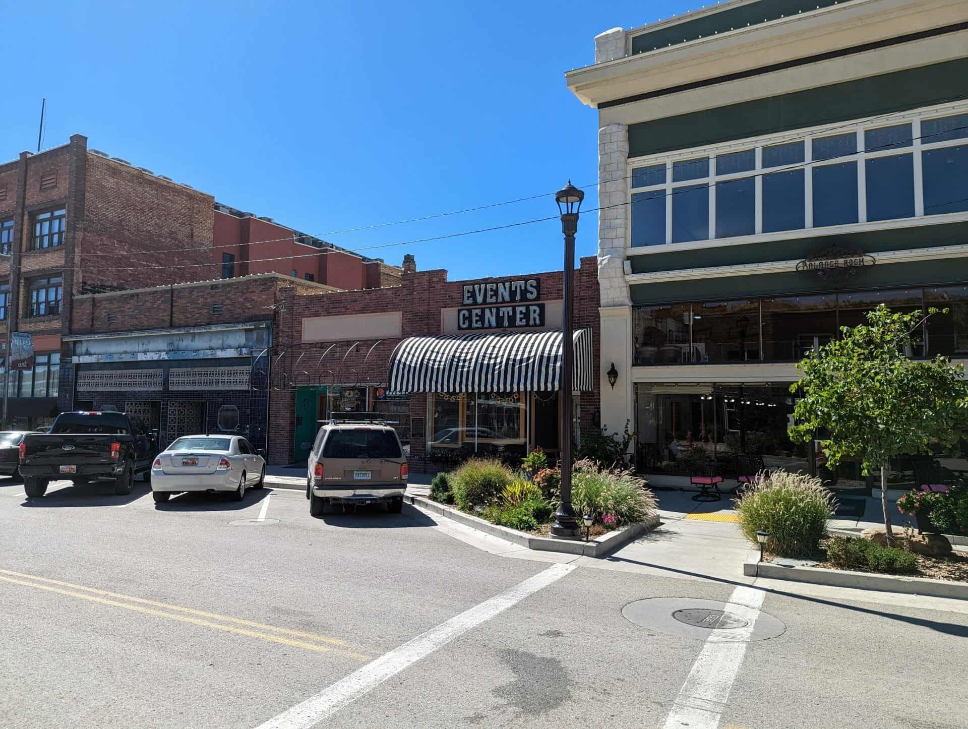
This two-story brick commercial building was constructed in 1929. The varied shades of tan bricks are unusual in the historic district. In the early 1930s, the right side of the building was occupied by the “Smart Shop” owned by N. A. Neilson, and the second story housed professional offices. Thorit and Janet Hatch operated the Helper Insurance and Loan Company here for many years.
This valley was originally settled in 1881 by Teancum Pratt. The original Pratt Survey still predominates on maps of this area. He sold land to the Rio Grande Western Railroad for a right of way. By the fall of 1887 the railroad had built 27 frame residences and from this start the town continued to grow. With the completion of the standard gauging of track in 1891, a terminal was established in this area.
It took extra engines to push trains over Soldier Summit, these extra locomotives were called “Helpers” and it was from this source that Helper was named.
With a mixed population of practically every nationality, Helper grew into a booming town. In 1907 Helper Township was incorporated.
This historic marker is located at the old Helper City Hall Building at 73 South Main Street in Helper, Utah and was dedicated by the Matt Warner Chapter 1900 of E Clampus Vitus on July 11, 1987 and remounted and rededicated July 8, 1995.
This one-story red brick flat roof building was built as the Helper City Hall in 1927. This building has classical “tin” cornices, columns and pediment. The project architect was Walter E. Ware of Salt Lake City.
The City Hall has been a center of community events since it was built. The building has always served as Helper’s City Hall, maintains its original appearence and contributes to the historic qualities of the Helper Historic District.
Marker Placed in 1997 by Division of State History. ( CR-07-735.)
Star Dancing Erected June 1, 2010 The Star of Helper represents the sky like the town and has no bounds. The Star also represents Helper as Utah’s Christmas Town. Donated by: Marie Camille Truscott Lentsch (a former Helper resident) Kirt E. Mascaro Helper City Councilman, 2010
Presented to Helper City We pledge allegiange to the flag of the United States of America and to the Republic for which it stands one Nation, Indivisible, with Liberty and Justice for all.
Presented and dedicated by Price Lodge No. 1550, B. P. O. Elks June 14 – 1952
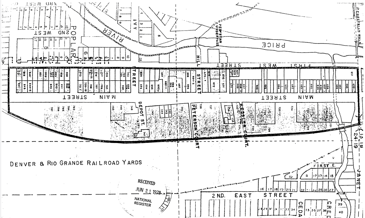
The Helper commercial district is located within the present city limits of Helper, Utah. The District is entirely within the E 1/2 of the NE 1/4 of Section 24, Township 13 South, Range 9E Salt Lake City Standard Meridian. The District is bounded on the north by Janet Street, on the west by First West Street, on the South by Locust Street and on the east by the Denver and Rio Grande Western (D&RGW) railyards. The size of the district is somewhat less than 40 acres and includes, but is not limited to, the entire extent of Pratt’s and Mead’s Survey Platts.
The existing boundaries were selected because of their tight nature, delineating the main Helper commercial district, as well as access points to that area. The inclusion of residences was determined by both their presence on Main Street or their adjacent location to the street and within business district, other residences were excluded and may be part of a future multiple resource nomination.
Janet Street is the northern boundary, and with its underpass (to the east) represents the effective beginning of Helper’s Main Street. On the west is First West Street which contains some residences, but included major rear access ways to the commercial buildings on Main Street. Locust Street boarders the district on the south, representing the end of the main commercial area. The eastern boundary follows the Rio Grande Western railway yards, which formed a vital part of Helper’s commercial life.
The Helper commercial district consists of a total of 110 of which 98 sites have been judged to be potentially contributory to the historic character of the area. A wide variety of both residential and commercial structures, arrayed along both sides of Main street in a north-south manner, comprise the district.
The Helper Commercial District was listed on the National Register of Historic Places (#79002491) on July 24, 1979.
The residential buildings are generally one story and are fairly modest in appearance. Several styles and building materials were utilized, including; hand hewn stone, wood frame, stucco, and several types of brick. The commercial buildings also exhibit a wide degree of variability, although they are generally consistent in scale, with almost all buildings being one to two stories in height. The predominate building material was red brick, although hand hewn stone stucco, wood frame, and other types of brick were also utilized.
Comparison of the present appearance of the district with early Sanborn maps and historic photos indicates that the area still retains much of its historic character. Prior to 1927 the area east of Main Street was dominated by Denver and Rio Grande Western (D&RGW) railroad company houses, but after that time, the area began to acquire the predominately commercial appearance it retains today. The modifications of the residential buildings have been fairly minor and have generally consisted of “modern” siding materials and additions, and modification of the porches. The commercial seen facade modifications, many of which are the installation of the enclosure or buildings have often minor and reversable.
A description of each contributory building along with its capsule history is given below. The buildings are listed by their Utah Historical Society site inventory number.
This one-story vernacular (the common building style of a period or place) house was built in 1903 of hand-hewn stone laid in a random ashlar pattern. The original part of the building is a late example of a hall-parlor house type, which was common in Utah during the second half of the nineteenth century. The house was built by John Bottino and used as a rental property until 1944 when his son, Jim, acquired the property and lived here with his wife, Ida.
Organized and built by the Greek immigrants of Carbon County. Dedicated August 15, 1916 by Reverend Mark E. Petrakis. Built in traditional byzantine style.
The Hellenic Orthodox Church of the Assumption is located at 61 South 200 East in Price, Utah and it was added to the National Register of Historic Places (#73001861) on April 11, 1973.
The following is from the nomination form for the National Register:
The Hellenic Orthodox Church of the Assumption at Price, Utah was dedicated August 15, 1916. The Greek immigrant was the last of the Europeans to come to America and the church at Price was the thirty-third Greek Orthodox Church established in North and South America.
In 1900 there were only three Greeks in Utah, During the Carbon County coal miners’ strike in 1903-1904 Greeks were first brought into the Price area as strike breakers. By 1916 there were 3,000 young Greek men working in the coal mines of Carbon County.
“To the Mormons the Greeks were interlopers among the ‘white’ population; they were clannish, would not marry outsiders, and thought they were an exceptional people with the only true religion on earth…. The Mormons were also clannish, would not marry outsiders, and thought they were an exceptional people with the only true religion on earth,” (Helen Zeese Papanikolgs, Toil and Rage in a New Land, p.143.) The result was a clash of cultures which was intensified by the abuses suffered by the Greeks in the coal mines and camps.
Plans were drawn as early as 1912 for a Greek Orthodox Church, however it was not until August 15, 1916 that construction had been completed and the church was consecrated.
The leaders of the movement to construct a church were Stylian Staes, Emmanuel Salevurakis and Gust Pappas. In 1914 a church had been established in Helper. During 1914 the Greeks from Price met with those of Helper in an effort to convince them that there should be a permanent church building erected in Price, (The church services at Helper were held in a Greek Coffee House.) Eventually the Helper Greeks agreed to aid in the construction of a church in Price.
An attempt was made to secure the donation of a plot of land by Price City, however this was voted down by the Price City Council The land was finally purchased from Lars and Sadie Gunderson for $800.00.
On March 7, 1916 bids were opened for the construction of the church, Lars Gunderson had submitted the lowest bid, $11,336,00, for construction of the church without a heating plant, and the bid of $968,00 for a furnace.
On the day of consecration special trains ran from all the coal camps bringing men to Price for the celebration. They were met at the station by the Sunnyside Italian band which escorted the men to the church. The procession to the church was characterized by shouting and the shooting of guns for good luck to the church.
The church was very important to the Greek population of the county. It gave them a sense of security and stood as a symbol that they had made a permanent settlement. This encouraged the Greek men to send for their wives or, for the majority who were single, to request that Greek girls be sent over for them to marry. In the beginning most of the Greek men had come to America with the idea of earning as much money as possible and then returning to their homeland.
The construction of the church was also significant because it came at a time when foreigners, especially Southern and Eastern Europeans, were regarded as an inferior menace to America. In this respect the church served as a sanctuary for the Greeks from both the intolerance of the American public and the abuses of the coal mines.
The immigrants served by the church were an important element in Utah history sharing in strikes, labor wars, attempted lynchings, Ku Klux Klan attacks, mine explosions and accidents, the Depression and war. In their own way the early Greek immigrants who built the Greek Church of the Assumption were just as much pioneers as were the Mormons who came to Utah more than fifty years earlier.
The original church was of traditional Byzantine construction in which the dome rests on a square supported by four pillars with the nave of the church in the form of a cross. It was built of yellow colored brick with a foundation of cement.
In 1940-41 a new entrance, two towers on the outside front, and an inside balcony were added. The original wooden columns were replaced by four cast Corinthian columns.
A fire in 1945 caused considerable smoke and water damage. The altar and environs were badly marred. A new tableau was built and the Rev. Zoygraphos of Texas, a Greek priest and iconographer, was commissioned to paint new icons for the entire church to replace the original ones ruined by the fire.
The icons, religious images painted on panels, have been called the “Bible of the Unlettered.” They cover the iconostasion or altar screen. The central large figure on the middle door of the altar m screen, the Royal Gate, which slides open to reveal the altar, is of Christ the Arch Priest, while other icons always include Christ on the right, Virgin and Child on the left, etc. The second and third rows above show scenes from the life of Christ and the twelve Apostles respectively. There are icons on the two sides of the church, while the four pendentives depict the Evangelists: Matthew, Mark, Luke and John, The most awe-inspiring scene of all fills the concavity of the top of the dome and is a symbolic representation of God the Father, surrounded by an angelic host, holding the world in His left hand. The vertical walls of the dome are covered by portraits of Old Testament prophets and contain numerous round, stained and leaded glass windows; they cast a subdued, even light on the contents of the dome.
Another artifact of singular beauty is the massive brass and crystal chandelier which hangs by a huge iron chain from the center of the dome. It was a feature of the original church and the sum of $560 was raised for it by the Greek miners of Hiawatha, a coal mining camp of southwestern Carbon County. It was also extensively damaged by the fire, but was repaired and restored at a cost close to its original value.
In 1961 the church was again enlarged, however the basic integrity of the church has been maintained in spite of two remodelings and one fire-induced renovation. In fact, these programs have added to and enhanced the structure while producing much-needed space. On each side of the church are three of the original stained and leaded glass windows. Another is in the east end of the church behind the altar. A dozen of the original small, round, stained and leaded windows augment the sides of the dome. The size of the building as it now stands is 87 feet 8 inches long by 43 feet six inches wide.
Matt Warner left home in 1879 at age 15, thinking he had killed a rival in a fight over a girl. He lived his early life on the outlaw trail as a bandit and rustler and was sent to prison on September 21, 1896.
Matt was pardoned by Governor Wells on January 21, 1900. He settled in Price and spent his remaining 38 years as a productive member of society; serving as deputy Sheriff, Justice of the Peace, detective and night policeman. In 1912 he ran for Sheriff but was defeated because he ran under his real name of Willard Christiansen and nobody knew who that was. Matt lived in this house until his death on December 21, 1938.
This historic marker was dedicated by the Matt Warner Chapter 1900 of E Clampus Vitus on July 19, 1997 and is located at 55 South 200 East in Price, Utah
The Rainbow Inn is located at 305 N Mains St, Helper, Utah and was built in 1922. Originally owned by Lena Fodero, the building was used as a hotel, bar, and sporting house. It was known for the bordello on the upper floor. The railroad which serviced the Spring Canyon coal mining towns went directly past the Rainbow Inn. It’s location drew many single male immigrants who were working on the railroad, at the power plants and in the coal mines.
It was purchased by Stephen M. Johnson on May 1, 1980 and used as a bar. On July 23, 1983, The Rainbow Inn became the first official watering hole of the Utah out post, known as Matt Warner, of the Mountain Charlie Chapter of E Clampus Vitus. The Rainbow Inn closed its doors in 1987.
This marker was erected in 2017 by Matt Warner Chapter 1900 E Clampus Vitus.