• About JacobBarlow.com
  • Cemeteries in Utah
  • D.U.P. Markers
  • Doors
  • Exploring Utah Email List
  • Geocaching
  • Historic Marker Map
  • Links
  • Movie/TV Show Filming Locations
  • Oldest in Utah
  • Other Travels
  • Photos Then and Now
  • S.U.P. Markers
  • U.P.T.L.A. Markers
  • Utah Cities and Places.
  • Utah Homes for Sale
  • Utah Treasure Hunt

JacobBarlow.com

~ Exploring with Jacob Barlow

JacobBarlow.com

Tag Archives: E Clampus Vitus

Daggett

26 Sunday Jun 2022

Posted by Jacob Barlow in Uncategorized

≈ Leave a comment

Tags

California, Daggett, E Clampus Vitus, Historic Markers, San Bernardino County

This community long served as a supply point and railhead for the mines of Death Valley and Calico. In the early 1880’s the first borax produced in Death Valley was hauled by mule team to the Atlantic & Pacific R.R. (later the Santa Fe) at Daggett. The station formerly Calico, was established in 1882 to service the silver mines, but was soon renamed for Lt. Gov. John Daggett. In 1888 it was connected to Calico by the narrow gauge Calico R.R. Silver prices dropped in the early 1890’s and the mines closed. At this time rich borax deposits were being worked at nearby Borate. 20 mule teams hauled the borax to Daggett for rail shipment. An era ended in 1898 when the famous teams were replaced by the Borate & Daggett R.R. By 1907 borax mining had ceased in favor of richer deposits near Death Valley.

This plaque (located in Daggett, California) was placed by the Billy Holcomb chapter of the ancient and honorable order of E Clampus Vitus, in cooperation with the Daggett Historical Society on Oct. 15, 1995.

The 1910 Flood

10 Friday Jun 2022

Posted by Jacob Barlow in Uncategorized

≈ Leave a comment

Tags

Caliente, E Clampus Vitus, Historic Markers, Lincoln County, Nevada

The 1910 Flood

Residents of desert areas know that flooding is always a possibility. In 1910, one of the worst rainstorms in southern Nevada history hit Lincoln County and Clark Counties, causing damage from Meadow Valley Wash to the Vegas Valley. In 1905, the San Pedro, Los Angeles, and Salt Lake Railroad was built through the Meadow Valley Wash to the Caliente, where it turned basically northeast to follow Clover Creek. While the route was the best in the areas, planning for floods turned out to be insufficient. In 1906, 1907 and 1909, flooding washed out the tracks, causing the railroad to be stopped until repairs were made. In each case, the route was repaired, but nature was not finished with it. In the first week of January 1910, massive flooding again washed out nearly 100 miles of tracks, taking an entire engine and cars with it. Two weeks later, more flooding took out the temporary repairs which had been made. The flooding extended into the Vegas valley, cutting off all travel out of the valley for a few days. More flooding in 1911 caused the railroad to rethink its location. The rails were moved significantly higher along the Meadow Valley Wash and through the Clover Creek area. This changed allowed the railroad to survive later massive floods, most notably in 1938, and remains the route use by the railroad today.

This historic marker was dedicated October 16, 2016 in Caliente, Nevada by the Queho Posse Chapter 1919 of E Clampus Vitus in conjunction with the City of Caliente.

Related:

  • E Clampus Vitus Markers

Jean, Nevada

06 Thursday Aug 2020

Posted by Jacob Barlow in Uncategorized

≈ Leave a comment

Tags

E Clampus Vitus, Historic Markers, Jean, Nevada

A historic marker about Jean, Nevada located in Jean, Nevada.

Founded in 1904 as Goodsprings Junction, a station on the San Pedro, Los Angeles and Salt Lake Railroad, Jean received its current name in 1905 when the post office was opened. It was named in honor of Jean Fayle, the wife of George Fayle who had built a mercantile business and had the post office in his store.

The town enjoyed some growth with the building of the Yellow Pine Mining Company Railroad from Goodsprings to connect with the railroad here in 1911. By the time the Yellow Pine railroad was torn up in 1930, Jean was a stop for travelers on Highway 91 (today’s I-15).

Peter A. “Pop” Simon created a new motel-store-gas station- casino complex here called Pop’s Oasis in 1947. It was a favorite stop for many and lasted until 1988. In 1987, the Gold Strike Hotel and Gambling Hall opened, and continues to serve the traveling public.

The Yellow Pine Mining Company Railroad

05 Sunday Jul 2020

Posted by Jacob Barlow in Uncategorized

≈ Leave a comment

Tags

Clark County, E Clampus Vitus, Historic Markers, Jean, Nevada, Railroad

The Yellow Pine Mining Company Railroad, a historic marker in Jean, Nevada.

Built in 1911, the Yellow Pine Mining Company Railroad was a twelve and a half mile long narrow-gauge railroad connecting the town of Goodsprings to the Union Pacific Railroad here at Jean. The railroad was built from material purchased from the defunct Quartette Mine Railroad in Searchlight, Nevada. The Yellow Pine Mining District covered the area around Goodsprings and the Sandy Valley area. The primary ores mined were zinc and lead. Other mines produced gold, silver, platinum, palladium, copper, vanadium, molybdenum, nickel, cobalt, and uranium. The district went through several booms and busts, and be 1930 the railroad was out of business. The rails were torn up in 1934, but the right-of-way can still be seen along the road between Jean and Goodsprings.

The Arrowhead Trail Highway

05 Friday Jun 2020

Posted by Jacob Barlow in Uncategorized

≈ Leave a comment

Tags

Arrowhead Trail Highway, Clark County, E Clampus Vitus, Historic Markers, Jean, Nevada

A historic marker in Jean, Nevada.

The first automobile road to connect Los Angeles and Las Vegas was the Arrowhead Trail Highway. Planned, promoted and built beginning i the second decade of the twentieth century, this was one of the named interstate highways of the Good Roads movement. The Arrowhead Trail Highway eventually connected Los Angeles, across the desert to Las Vegas, and then north to Salt Lake City. The road was later numbered Highway 91, and parts of the road are now part of Interstate 15. The final route of the Arrowhead Trail Highway entered Nevada at today’s Primm, and followed a dirt road to Las Vegas. In Las Vegas, it became Fifth Street, and later Las Vegas Boulevard. You can still follow the 1920s route from Jean through Las Vegas, by taking Las Vegas Boulevard from here.

Related Posts:

  • Arrowhead Trail 1914-1924
  • From Native American Trail to Interstate Exit

Woodside/Price River Ranches/D&RGW Narrow Gauge

15 Friday May 2020

Posted by Jacob Barlow in Uncategorized

≈ Leave a comment

Tags

E Clampus Vitus, Historic Markers, utah

Woodside/Price River Ranches/D&RGW Narrow Gauge

A historic marker located at the Horse Canyon View Area in Emery County, Utah just off highway 6.

Woodside

The area’s first resident was a local prospector named Henry H. Hutchinson, who settled there in 1881. Other homesteaders arrived the next year and started digging an irrigation canal. Attracted by relatively abundant water and an extensive growth of cottonwood trees, they founded a settlement known as Lower Crossing. Lower Crossing was also home to some of the Chinese laborers imported to construct the narrow gauge railroad. As the town grew, adding a few stores and a blacksmith shop, it was renamed “Woodside” for the cottonwood groves. By 1900 the population stood at 114. Cattlemen used the town for mail and freight and sugar cane was raised to produce sorghum and molasses. By 1910 there were schools, saloons, a large hotel and the population had reached 328. The population dropped to 300 by 1920. In the late 1920 Woodside’s livestock shipping facilities and railroad station were taken away when the railroad consolidated its operations in Helper. This blow was followed by severe droughts in the 1930s, and by 1940 the population had dropped to 30.

In the 1940s Woodside became a minor tourist attraction. In the 1880s the railroad had dug a large water well here, which had later turned into a cold bubbling mud pot driven by naturally-occurring pressurized carbon dioxide gas. The hole was developed into a cold water geyser along with a filling station, store, and café.

In 1924, Utah Oil & Refining drilled the Woodside #1 well, located about three and a half miles southwest of the town. The well did not encounter oil, but rather, a large flow of helium-rich gas. President Calvin Coolidge set aside the “Woodside Dome Field” as “United States Helium Reserve #1”. Today, it remains an untapped helium resource.

In the 1960s, the Highway Beautification Act led to the removal of a number of billboards advertising the town’s geyser along U.S. Route 6, which had a major impact on tourist visits. The cafe and store burned down around 1970, and the geyser and filling station are the only remnants of Woodside. The geyser formerly spouted as high as 75 feet but is much lower now.

Price River Ranches

The area you see to the west of this monument would not seem suitable for human habitation. Access is difficult to say the least. The Price River has an immense drainage basin and far away cloudbursts cause flooding and damage without warning. The weather is extremely hot in the summer and the cold is just as extreme in the winter. The area is home to many species of predators.

Marsing Ranch

As inhospitable as this country seems, around the turn of the century Alma and Annabelle Marsing homesteaded here. They named their ranch the Red Cliffs Ranch and raised their family in this isolated area. Annabelle was buried on the ranch in January of 1919. In addition to the Red Cliff Ranch there is reference to the Grimes place and the Newkirk place, both nearby. The Marsing cattle brand is a wrench/cross named for a wagon wrench. It was recorded by Alma Marsing on July 23rd, 1900 and is still in use today.

Dickman’s Tunnel Ranch

Henry and Charity Dickman operated what became known as the Tunnel Ranch just a few miles downstream from the Red Cliffs Ranch at about the same time. They used the abandoned D&RGW narrow gauge tunnel as a head-gate and diversion ditch to supply water for irrigation at the ranch. They also raised their family on the ranch and contended with the erratic flow of the Price River. Charity Dickman also served as Postmaster of the Woodside Post Office from October of 1935 to November of 1945. This ranch is still active today although no one lives on the site.

Silvagni Ranch

The Silvagni Ranch lies between the Tunnel Ranch and Woodside. Like other ranches it lies along the Price River and water is a constant problem whether it be too much or too little. It is active today although some years it may lie fallow for lack of water. It has many acres of good flat cultivatable fields.

D&RGW Narrow Gauge

The D&RGW narrow gauge railroad was incorporated in Colorado in 1870. 10 years later William Jackson Palmer, president of the line, decided to extend his influence into Utah. In July, 1881 the Denver & Rio Grande Western Railroad was organized for this purpose. Though several routes were considered and at least one, across the Buckhorn Desert and through Salina Canyon, had extensive grade work completed it was eventually decided to bend the rails northward along the Price River and up Price Canyon and on to Salt Lake. The most interesting part of the original narrow gauge line is along the Price River northwest of the tiny ghost town of Woodside. The surveyors had the rails follow the river because the grades were mild and the curves were no tighter than other places along the line. This alignment required the Price River to be crossed 18 times in the six miles between Woodside and the Grassy Siding. They also encountered a long, thin fin of rock sticking out into the canyon. Instead of following the river at this point, which would have added an extra mile to the route, they simply poked a hole through the 98 foot thick sandstone fin, bridged the river immediately on the other side and continued upstream. This short tunnel was used from 1882 until 1890 when the line was converted to standard gauge and re-aligned along its present course. This tunnel is the only narrow gauge tunnel to be used on the main line in Utah. The tunnel now serves as a head-gate and diversion point for water to the Tunnel and Silvagni ranches. The tunnel is about two miles west of this location on private property.

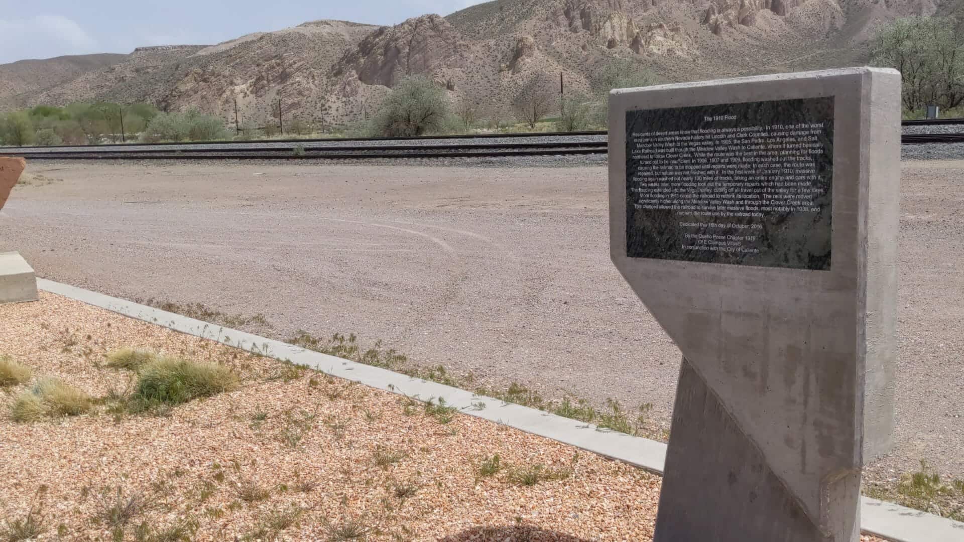
Dedicated September 12, 2015 (6020)
Matt Warner Chapter 1900
E Clampus Vitus

Mojave Road

28 Sunday Dec 2014

Posted by Jacob Barlow in Uncategorized

≈ 4 Comments

Tags

California, California Historic Markers, E Clampus Vitus, Historic Markers

2018-07-23 16.42.02

Mojave Road

Long ago Mohave Indians used a network of Pathways to cross the Mojave Desert. In 1826 American trapper Jedediah Smith used their Paths and became the first non-Indian to Reach the California coast overland from Mid-America. The paths were worked into a Military wagon road in 1859. This Mojave road remained a major link between Los Angeles And points east until a railroad crossed the Desert in 1883.

California registered Historical landmark no. 963 located at the Clyde V. Kane Rest Area.

Plaque placed by the state department of parks And recreation in cooperation with Billy Holcomb chapter of E Clampus Vitus, bureau of land management and Mojave River Valley Museum Association Oct. 9, 1988.

Related:

  • California Historical Landmarks
2018-07-23 16.42.05
2018-07-23 16.41.59
picture27dec07-143
picture27dec07-142

Harry Wade Exit Route

26 Wednesday Nov 2014

Posted by Jacob Barlow in Uncategorized

≈ 3 Comments

Tags

CA Historic Markers, California, Death Valley, E Clampus Vitus, historic, San Bernardino County

picture27nov08-013

Some 100 wagons found themselves in Salt Lake City too late to cross the Sierra Nevada. They banded together under the name of Sand Walking Co. and started for the gold fields in California over the old Spanish Trail. After being in Death Valley with the ill-fated 1849 caravan, Harry Wade found this exit route for his ox-drawn wagon, thereby saving his life and those of his wife and children. At this point the Wade party came upon the known Spanish trail to Cajon Pass.

Originally registered October 9, 1957. Plaque provided by the descendants of Harry Wade. Dedicated by Death Valley ’49ers in cooperation with the San Bernardino County Board of Supervisors and California State Park Commission, November 8, 1967. new plaque provided and dedicated by the ancient and honorable order of E Clampus Vitus, November 13, 1999.

Other California Historical Landmarks.

The Wade family was part of the Bennett-Arcan party that was guided by William Lewis Manly through Death Valley late in 1849. The memoirs of Manly (available for free at Project Gutenberg: http://www.gutenberg.org) are fascinating reading, but he makes no mention of the Wades in them. Piecing together the story takes some time and patience, especially as there were several “ill-fated” caravans that trekked through Death Valley in 1849.

The well-graded dirt road that runs west from the marker follows the approximate route that the Wades took out of Death Valley; it joins the paved N-S road through Death Valley National Park near Shoreline Butte.

Two interesting bits of information: first, while the marker was dedicated on the date cited, below, it was registered by the COHP on 9 October, 1957; second, in 1994, Death Valley National Monument became a National Park, and was increased in size by about a third. The new southern boundary runs along the north side of the dirt road.

Newer posts →

Follow Jacob

Follow Jacob

Blog Stats

  • 2,061,320 hits

Social and Other Links

BarlowLinks.com

Recent Posts

  • Arthur Miles Home
  • Navajo Shadehouse Museum
  • Impossible Canyons
  • The Old Hurricane Bell
  • Goulds Shearing Corral

Archives

Loading Comments...