• About JacobBarlow.com
  • Cemeteries in Utah
  • D.U.P. Markers
  • Doors
  • Exploring Utah Email List
  • Geocaching
  • Historic Marker Map
  • Links
  • Movie/TV Show Filming Locations
  • Oldest in Utah
  • Other Travels
  • Photos Then and Now
  • S.U.P. Markers
  • U.P.T.L.A. Markers
  • Utah Cities and Places.
  • Utah Homes for Sale
  • Utah Treasure Hunt

JacobBarlow.com

~ Exploring with Jacob Barlow

JacobBarlow.com

Tag Archives: Washington County

From Ditches to Pipes

22 Thursday Jun 2017

Posted by Jacob Barlow in Uncategorized

≈ 1 Comment

Tags

historic, Historic Markers, Leeds, utah, Washington County

2017-05-13 17.46.58

Water is life… The shovel is divine

From Ditches to Pipes

The use and control of water controls the future

The earliest settlers in Leeds used innovation and hard work to divert water from Leeds Creek to their homes, fields, and industry. The town pioneers carefully studied the lay of the land between the creek and the settlement and selected a route that would transport the water to Leeds. The lowly hand shovel was their “divine tool.” Digging ditches with pick and shovel and teams of work horses across the rocky terrain was hard and seemingly endless work. Ingenuity was required in keeping the path of the ditch in a
downhill direction to maintain water flow. Building a good ditch system took clever minds, strong backs, and great determination.

The Leeds Water Company was established in the late 1800s to legally secure and organize rights to use local water, a historically controversial and difficult task in the arid West.

The main ditch carried Leeds Creek water to the northeastern edge of the town. From that point, ditches conveyed the water to town lots and beyond to the nearby agricultural fields. Prized lots in Leeds were those that fronted the ditch, especially lots that were closest to the beginning of the ditch, where pollutants from upstream use of the water were fewer.
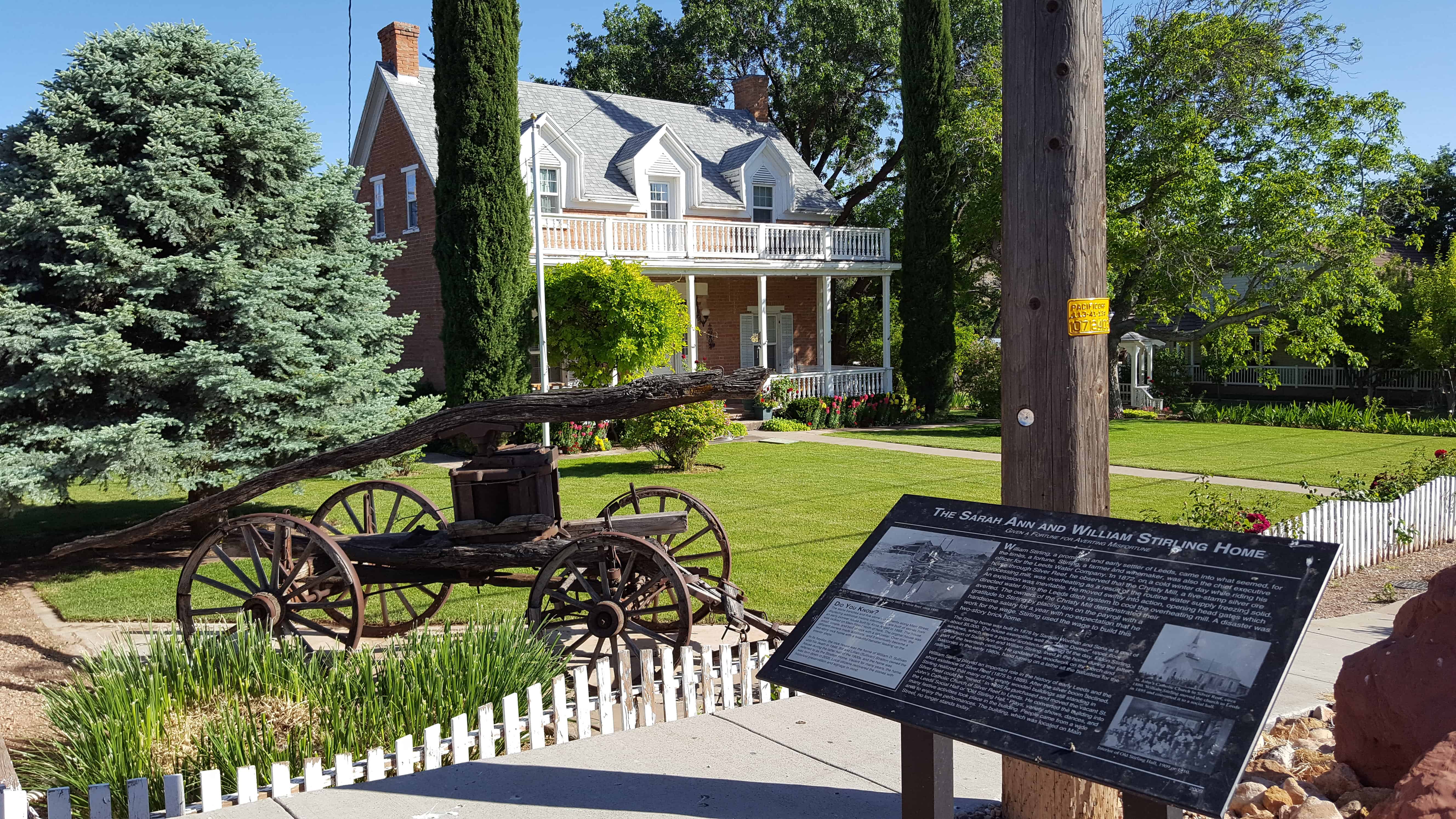
2017-05-13 17.47.02

Stirling Home

22 Thursday Jun 2017

Posted by Jacob Barlow in Uncategorized

≈ 1 Comment

Tags

historic, Historic Homes, Historic Markers, Leeds, NRHP, utah, Washington County

2017-05-13 17.44.56Stiring Home

Built c. 1876 of red brick by Samuel Worthen and sons for William Stirling, one of the first settlers of Leeds.  Fine example of “Dixie Dormers” unique to Southern Utah.  Marker placed 1973 by Mrs. David Stirling and Family.

2017-05-13 17.45.19

William Stirling, a prominent and early settler of Leeds, came into what seemed, for the times, a fortune. Stirling, a farmer and winemaker, was also the chief executive officer for the Leeds Water Company. In 1872, on a cold winter day while riding his horse through Silver Reef, he observed that the Christy Mill, a five-stamp silver ore processing mill, was overheating as a result of the routine water supply freezing solid. An explosion was inevitable. He moved swiftly into action, opening head gates which directed water from the Leeds ditch system to cool the overheating mill. A disaster was averted. The owners of the Christy Mill demonstrated their gratitude to Stirling by placing him on the payroll with a handsome salary for a year with no expectation that he work for the wage. Stirling used the wage to build this two-story brick home.

The Stirling home was built in 1876 by Samuel Worthen and Sons at a cost of about $5,000. The house exemplifies well the “Dixie Dormer” upper floor windows, which were a popular architectural design of the day. Eldon Stirling, grandson of Sarah Ann and William Stirling, lived in the home during the latter part of the twentieth century. He updated the woodwork on the porch and balconies in the early 1980s, hand turning on a lathe all the balusters for the railings

William Stirling played an important role in the history of early Leeds and the short existence of Silver Reef (1875 to 1889). After the silver boom declined, Stirling realized that many of the empty wooden buildings still standing in Silver Reef could be “mined.” In 1895 he purchased and moved the vacant St.
John’s Catholic Church of Silver Reef to Leeds. He converted the building into the Leeds Social Hall or “Old Stirling Hall.” Plays, variety shows, dances, and many festive activities took place in the building. People came from a wide area to enjoy the performances. The building, which was located on Main Street, no longer stands today.(*)

2017-05-13 17.45.51

2017-05-13 17.45.56

Harrisburg Historic Pioneer Cemetery

26 Wednesday Apr 2017

Posted by Jacob Barlow in Uncategorized

≈ 1 Comment

Tags

Cemeteries, Harrisburg, historic, Leeds, Silver Reef, SUP, utah, Washington County

2017-03-19 16.12.14

Honoring early Harrisburg Pioneers and their infants and children

Surname Given Name Middle/Maiden Birth Death
Cox Willard Glover 13 Feb 1887 7 Aug 1887
Daily Sarah Jane Wilson 21 Dec 1830 22 Oct 1873
Earl Eliza 1 May 1864 (Died as Child)
Earl Wilbur Joseph 29 Mar 1817 6 Aug 1874
Fuller Anne Belle Campkin 12 Aug 1841 11 Sep 1878
Fuller Elizabeth Vaughn 3 Oct 1845 7 Jan 1865
Fuller Elizabeth Vaughn 4 Jan 1865 4 Jan 1865
Fuller Orrin Eugene 8 May 1872 8 May 1872
Goddard Mary Ann Pace 20 Oct 1835 1915
Goddard William Pettibone 10 Jan 1827 1903
Hamilton Abel 28 Jan 1974 11 Oct 1874
Harris Bernice 4 Aug 1897 11 Feb 1898
Jolley John Bryant 1 Feb 1868 8 Feb 1868
Jolley Mary Ann Harris 25 Feb 1851 10 Feb 1868
Leany David 29 Dec 1877 10 Jun 1879
Leany Edwin 22 Apr 1876 28 Apr 1876
Leany Elizabeth Scearce 4 Jan 1822 9 Jun 1908
Leany Ellen 19 Dec 1878 21 Aug 1879
Leany Elmer 9 Dec 1906 14 Dec 1906
Leany Mary 19 Dec 1859 22 Jan 1915
Leany Mary Elizabeth 3 Nov 1869 3 Nov 1869

Leany Thomas Jefferson 4 Jul 1865 11 Dec 1896
Leany William Condie 19 Dec 1876 22 Mar 1877
Leany William 19 Dec 1815 29 Dec 1891
McCleve John Taylor 27 Mar 1845 5 Jun 1867
McMullin Martha Richards 2 Oct 1814 11 Jun 1867
McMullin Mary Ann Holmes 2 Jul 1836 12 Dec 1895
McMullin Willard Glover 21 Feb 1823 17 Oct 1884
Meeks Charles Mason 31 Mar 1872 25 Oct 1873
Meeks John Priddy 29 Sep 1863 11 Oct 1863
Mulford Furman 27 Jul 1812 23 Jan 1865
Newton Ann Jacques 16 Nov 1813 1 Nov 1892
Newton Elizabeth Ann 12 May 1860 30 Mar 1866
Newton John 1 May 1815 16 Jun 1864
Robb (Baby Boy) 26 Apr 1873 26 Apr 1873
Robb Albert 18 Sep 1866 21 Apr 1868
Robb Susannah Drummond 13 Nov 1837 26 Apr 1873
Robb Susannah 4 Jan 1864 Oct 1864

Note: After more than two year’s research in co-ordination with the Harrisburg Estates Homeowners Association (owners of this cemetery), this plaque was erected honoring early Harrisburg Pioneers and their infants and children.

See other historic markers in the series on this page for SUP Markers.

2017-03-19 16.13.23

2017-03-19 16.13.08

2017-03-19 16.11.59

2017-03-19 16.12.45

2017-03-19 16.12.19
2017-03-19 16.12.23
2017-03-19 16.12.32
2017-03-19 16.12.55
2017-03-19 16.13.15
2017-03-19 16.13.29
2017-03-19 16.13.38
2017-03-19 16.13.52

Harrisburg Residents

26 Wednesday Apr 2017

Posted by Jacob Barlow in Uncategorized

≈ 1 Comment

Tags

Harrisburg, historic, Historic Buildings, Historic Homes, Historic Markers, Leeds, Silver Reef, SUP, utah, Washington, Washington County

2017-03-19 16.02.02

HARRISBURG RESIDENTS
Named here are the Heads of the Families who settled in Harrisburg between 1859 and 1928:
1859
Moses Harris
1860
James Lewis Hosea Stout
1862
William Leany Dr. Priddy Meeks John Brimhall
Orson Adams Elijah K. Fuller Samuel Hamilton
William Robb Rufus Allen Allen J. Stout
Mosiah L. Hancock Alfred J. Randall
1863
Willard G. McMullen Samuel Gould John Newton
David Ellsworth John McCleve Allen Taylor
William Taylor

1865
Henry E. Harrington Milton Daily Wilson Daily
Thomas Adair Willbur Earl William Stirling
AL Carpenter Jerome Asa
Robert Richardson Frank Owens

See other historic markers in the series on this page for SUP Markers.

Harrisburg, Utah

26 Wednesday Apr 2017

Posted by Jacob Barlow in Uncategorized

≈ 5 Comments

Tags

Ghost Towns, Harrisburg, historic, Leeds, Silver Reef, utah, Washington County

2017-03-19 15.58.19

Harrisburg posts:

  • Harrisburg (DUP Marker)
  • Harrisburg (E Clampus Vitus Marker)
  • Harrisburg  Historic Pioneer Cemetery (SUP Marker)
  • Harrisburg Residents (SUP Marker)
  • Tale of Three Towns

IMG_20170319_160726_981

IMG_20170319_160109_857

2017-03-19 15.58.58
2017-03-19 15.59.03
2017-03-19 15.59.07
2017-03-19 15.59.20
2017-03-19 15.59.47
2017-03-19 15.59.48
2017-03-19 16.00.27
2017-03-19 16.02.02
2017-03-19 16.02.31
2017-03-19 16.06.07

A Tale of Three Towns

26 Wednesday Apr 2017

Posted by Jacob Barlow in Uncategorized

≈ 3 Comments

Tags

Harrisburg, Historic Markers, Leeds, Silver Reef, utah, Washington, Washington County

2017-03-19 15.47.44

A Tale of Three Towns

The history of three towns—Harrisburg, Silver Reef, and Leeds—is
intricately connected. Harrisburg and Silver Reef are ghost towns today, while Leeds persists. Like many locations in the arid west, water and its availability and accessibility was the determining factor in whether a town lived or withered away.

Harrisburg

The first settlement in the area was Harrisburg, founded in 1861 by Moses Harris and a few Mormon families who settled along Quail Creek. Despite their efforts in digging a 5-mile-long irrigation canal along what is now known as Leeds Creek, growth was hampered by rocky soil and limited land available for farming. By 1876 Harrisburg was losing population and essentially failing. Today, remnants of a few pioneer homes and the restored Adams House are all that remain of Historic Harrisburg.

Silver Reef

About the same time Leeds was settled, silver was discovered on the White Reef. This reef, an upturned sandstone ledge, parallels I-15 from Harrisburg to a point north of Leeds. Miners and immigrants, including many of Irish, Cornish, and Chinese origin, rushed to the area with the hope of making their fortunes. The boomtown of Silver Reef sprang up about a mile north of Leeds, and by 1878 was a considerably larger community than either diminishing Harrisburg or the growing farming community of Leeds. At its height, Silver Reef boasted nearly a dozen mines and six ore processing mills, plus retail stores, saloons, hotels, banks, a school, Wells Fargo express office, theater company, and other urban amenities. Leeds and Silver Reef were a study in contrasts. Despite great differences in ethnicity, religion, and culture, the mining boomtown and its agricultural neighbor formed a mutually dependent relationship. The miners at Silver Reef were sustained by produce from Leeds, and Leeds farmers flourished with cash from the miners for their crops. By 1900 Silver Reef had died as the most easily accessible silver ore had been mined and the price of silver plummeted; however, the farming community of Leeds survived.

Leeds

By 1867 the Harrisburg pioneers realized that a place called “Road Valley,” just to the north, was more suitable for diverting water and cultivating farmland. Amidst controversy, but with direction from Mormon leader Erastus Snow, many families moved from Harrisburg to Road Valley. An irrigation ditch was dug and water was brought to the site. The town was organized on December 1, 1867, and named Bennington, in honor of the town’s bishop, Benjamin Stringham. Bishop Stringham later requested that the town be named after Leeds, England, where he had served as a Mormon missionary. In May of 1869, Bennington became Leeds.(*)

2017-03-19 15.49.27

Schoolhouse to Town Hall: A Building on the Move

26 Wednesday Apr 2017

Posted by Jacob Barlow in Uncategorized

≈ 1 Comment

Tags

historic, Historic Buildings, Historic Markers, Leeds, utah, Washington County

2017-03-19 15.47.44

FROM SCHOOLHOUSE TO TOWN HALL: A BUILDING ON THE MOVE

The building to your left was originally built as a schoolhouse in 1880 in nearby Silver Reef. It also served in the mining boomtown as a place for community dances and other gatherings.

Soon after the schoolhouse was built, Silver Reef began to decline in population, and by the early 1900s the building was no longer in use. At that time, the building was divided into two parts and moved on logs pulled by horses along the road, 2 miles from Silver Reef to its present site in Leeds. For more than five decades, until 1956, it served as the Leeds Schoolhouse. During most of that time, its two classrooms housed students in eight different grades.

After the school closed, the building was leased to and used by The Church of Jesus Christ of Latter-day Saints as a recreation center. Eventually it was remodeled and turned into a town hall and community gathering place for Leeds. The old school was reroofed and the small porch on the original building was expanded across the full length of the new town hall’s front.

LEEDS PEACHES: DID YOU KNOW? In the 30s, 40s, and 50s when the peach farming was booming in Leeds, peaches from the community were shipped throughout the West via rail from Cedar City. The local people working in the orchards and packing the bushel baskets with ripening peaches became curious about the cost consumer’s were paying for their peaches. So they began writing notes in the bottom of the baskets asking for people to write them back and let them know what they were paying. It was common to receive replies from as far away as Texas and Michigan. Compliments about how good the peaches tasted were often included with the replies.

2017-03-19 15.47.55
2017-03-19 15.49.15
2017-03-19 15.49.20

Snowfield Monument “Franciscan Fathers”

25 Tuesday Apr 2017

Posted by Jacob Barlow in Uncategorized

≈ 1 Comment

Tags

historic, Historic Markers, Snowfield, Spanish Explorers, Spanish Trail, SUP, utah, Washington County

2017-03-19 15.34.56

October 13, 1776: “we set out southward from the small river and campsite of Nuestra Señora del Pilar (“Our Lady of the Pillar” – Kolob Canyon of Zion Canyon National Park)…” and “We traveled a league and a half to the south, descended to the little Río del Pilar (Ash Creek) which here has a leafy cottonwood grove, crossed it, now leaving the valley of the Señor San José and entered a stony cut in form of a pass between two high sierra…” “We continued without a guide, and having traveled with great difficulty over the many stones for a league to the south, we descended a second time to the Río del Pilar and halted on its bank in a pretty cottonwood grove, naming the place San Daniel – Today five leagues south.”
Franciscan Fathers Atanasio Dominguez, Sylvestre Velez de Escalante and eight other members of a daring exploration party departed the Misión de Santa Fe, New Mexico on July 29, 1776, in an attempt to establish contact with the Franciscan mission at Monterey, California. Following previous expeditions into the Spanish borderlands they were able to cross the Colorado River near Grand Junction, Colorado, and entered the unexplored regions of the Great Basin near Spanish Fork, Utah. They then proceeded southward along the Wasatch Mountains expecting a westward flowing river that would eventually take them to the Pacific Ocean. Disappointed and facing the reality of winter snows they “cast lots” at a point near Cedar City, Utah, on October 11, 1776, and elected to return to Santa Fe by a southern route. Their encampment here at “San Daniel” represents the first recorded entry of non-native people into Washington County, Utah. The Fathers arrived back at the Santa Fe Mission on January 2, 1777, having traveled over 1800 miles and recording one of the greatest explorations in American history. Their observations and maps were instrumental in the opening of the American Southwest to further exploration and commercial use of the National Historic Old Spanish Trail.

See other historic markers in the series on this page for SUP Markers.

2017-03-19 15.35.04

2017-03-19 15.35.10


2017-03-19 15.35.20
2017-03-19 15.35.25
2017-03-19 15.35.53

2017-03-19 15.35.44

2017-03-19 15.36.07

The Historic Dixie-Long Valley, Utah Pioneer Trail

18 Saturday Mar 2017

Posted by Jacob Barlow in Uncategorized

≈ 1 Comment

Tags

historic, Historic Markers, Hurricane, SUP, utah, Washington County

2017-03-05 08.35.00

SUP Marker #118 in Hurricane.  (Also located here is #101B)

Segments of the old Indian trails between St. George and Long Valley were used by Mormon pioneers to settle Long Valley in 1864 and for its resettlement in 1871 following Indian conflicts. This trail scaled the Hurricane Fault on the Johnson Twist. One segment went south from Virgin City and then east and the other went east to Rockville-Crafton and then south to Big Plains where they merged. The desert trail, about 85 miles long, traversed deep sand, sandstone ledges and lava faults and was the primary transportation route, including mail and heavy freight, for half a century. It took four days for loaded wagons drawn by horse or ox teams to travel the distance.

See other historic markers in the series on this page for SUP Markers.

2017-03-05 08.35.06

2017-03-05 08.35.48
2017-03-05 08.35.39
2017-03-05 08.35.26
2017-03-05 08.35.13

The Historic Hurricane Canal

18 Saturday Mar 2017

Posted by Jacob Barlow in Uncategorized

≈ 1 Comment

Tags

Canals, historic, Historic Markers, Hurricane, La Verkin, SUP, utah, Washington County

2017-03-05 08.35.00

SUP Marker # 101B in Hurricane. (Also located here is #118)

When first conceived, the Hurricane Canal seemed like an impossible dream. Beginning at a point seven miles up the Virgin River, water had to travel through flumes, tunnels, and over deep ravines. The canal had to hang on steep, unstable cliffs and be tunneled through sections of mountain. To make matters more difficult, money was virtually non-existent for the local residents. Engineers said the canal could not be built.

Upriver, the little towns suffered from the flash floods of the wild Virgin River that devoured half their farmland. The men were desperate. More cultivated land was needed to support their growing families. In the fall of 1893, James Jepson of Virgin and John Steele of Toquierville envisioned and promoted the plan for the water to be brought to the “Hurricane Bench.” With a simple carpenter’s spirit level, they figured a feasible route, and men were recruited from neighboring towns. Isaac McFarlane, county surveyor, surveyed and estimated the construction cost at $53,000. The only tools available were picks, shovels, crowbars, and a homemade wheelbarrow. Over 100 hopeful me worked on the canal project the first few winters.

By 1902, long after the expected completion date, only eight to ten men were left working. Many of the men had sold their stock and quit. Expensive portions remained undone, and the few remaining men were broke and discouraged. Life was injected back into the project when Jepson went to Salt Lake City and convinced the LDS Church to buy $5,000 worth of canal stock. The influx of money restored morale; and now, giant powder to blast through tunnels and lumber to build the flumes could be purchased.

Two years later, August 6, 1904, the impossible dream came true as water flowed onto the Hurricane Bench from the canal, giving life to 2,000 acres of fertile land. The valley could now be settled. After twelve years of sacrifice, incredibly hard work, and true grit, a community was born, complete with real heroes.

The vision of two men, James Jepson and John Steele, along with the faith, dedication, and tenacity of many others, changed forever the lives and dreams of thousands of people in Utah’s Dixie. They did all this for their families. And they did it for us. We give thanks to these men of valor.

See other historic markers in the series on this page for SUP Markers.

2017-03-05 08.35.13

2017-03-05 08.35.48
2017-03-05 08.35.39
2017-03-05 08.35.26
2017-03-05 08.35.13
2017-03-05 08.35.06

← Older posts
Newer posts →

Follow Jacob

Follow Jacob

Blog Stats

  • 2,062,604 hits

Social and Other Links

BarlowLinks.com

Recent Posts

  • The Old Settler’s “Swallow’s Nest”
  • Arthur Miles Home
  • Navajo Shadehouse Museum
  • Impossible Canyons
  • The Old Hurricane Bell

Archives

Loading Comments...