• About JacobBarlow.com
  • Cemeteries in Utah
  • D.U.P. Markers
  • Doors
  • Exploring Utah Email List
  • Geocaching
  • Historic Marker Map
  • Links
  • Movie/TV Show Filming Locations
  • Oldest in Utah
  • Other Travels
  • Photos Then and Now
  • S.U.P. Markers
  • U.P.T.L.A. Markers
  • Utah Cities and Places.
  • Utah Homes for Sale
  • Utah Treasure Hunt

JacobBarlow.com

~ Exploring with Jacob Barlow

JacobBarlow.com

Monthly Archives: December 2017

Peace Treaty – Blackhawk War

15 Friday Dec 2017

Posted by Jacob Barlow in Uncategorized

≈ Leave a comment

Tags

Black Hawk War, Heber City, utah, Wasatch County

  • 2017-10-12 15.12.08

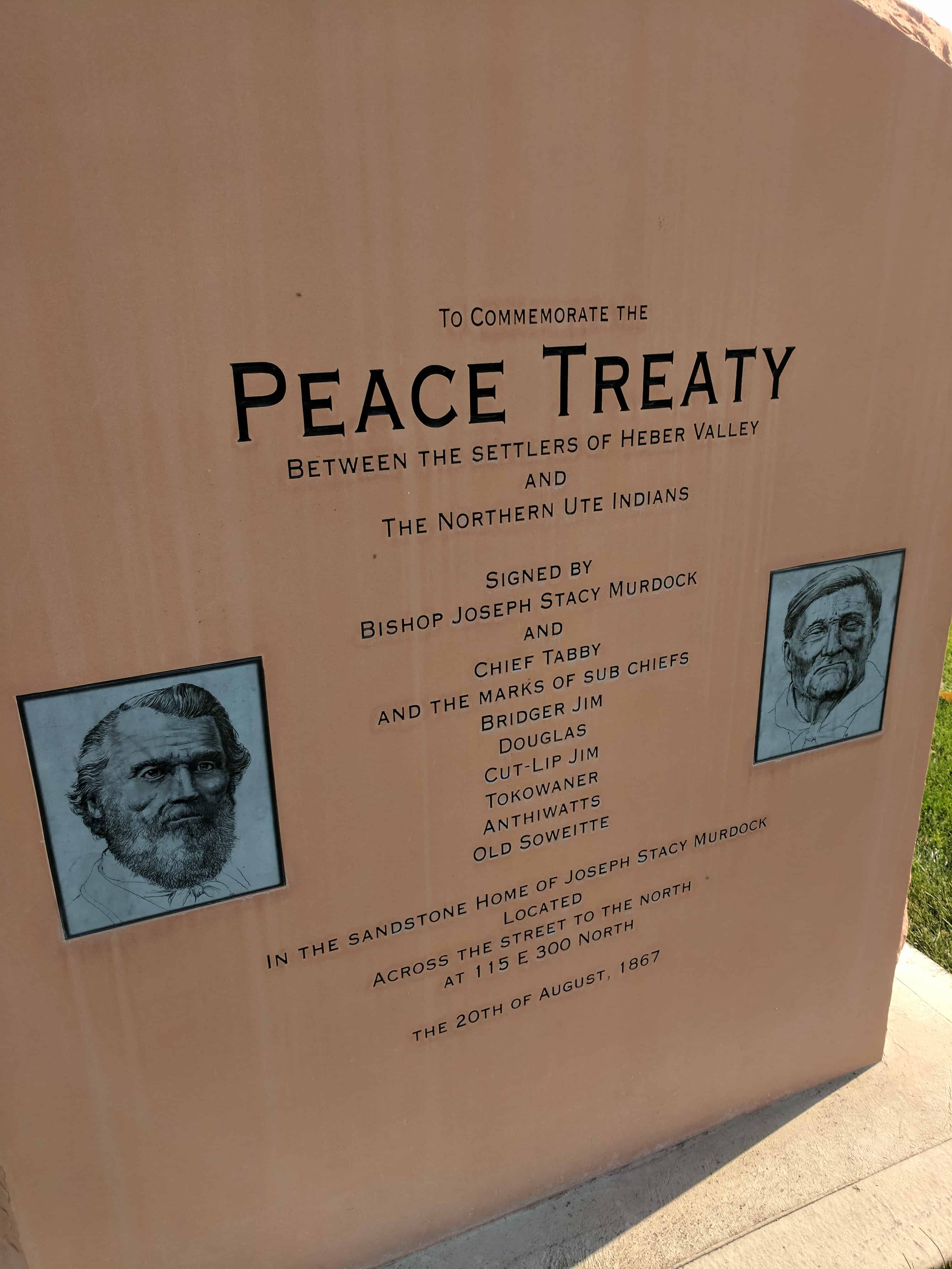
Location: 300 North 200 East, Heber, Utah

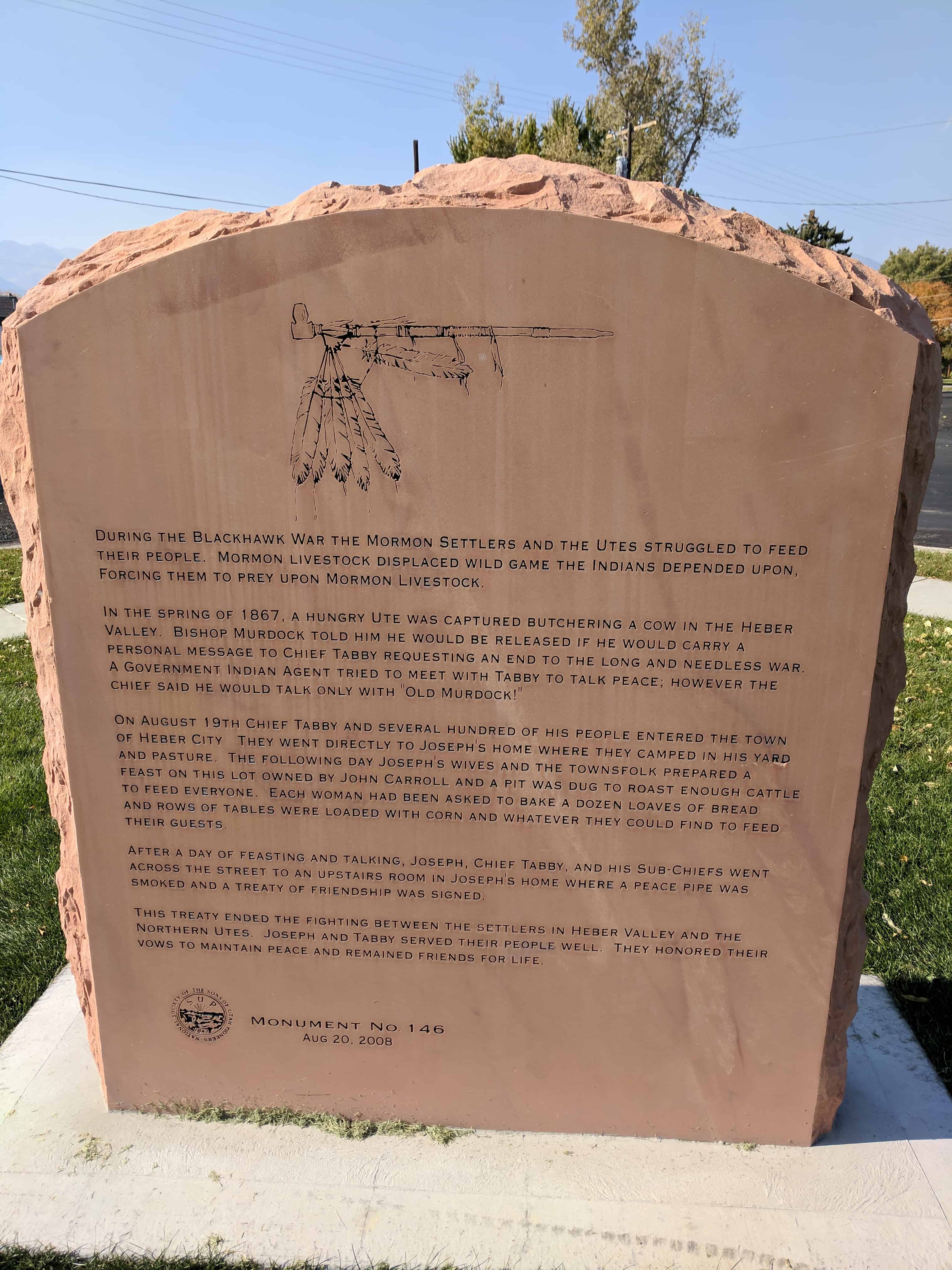
During the Blackhawk War the Mormon settlers and the Utes struggled to feed their people. Mormon livestock displaced wild game the Indians depended upon, forcing them to prey upon Mormon livestock.

In the spring of 1867, a hungry Ute was captured butchering a cow in the Heber Valley. Bishop Murdock told him he would be released if he would carry a personal message to Chief Tabby (Tabiona) requesting an end to the long and needless war. A government Indian agent tried to meet with Tabby to talk peace, however the Chief said he would talk only with “Old Murdock!”

On August 19th Chief Tabby and several hundred of his people entered the town of Heber City. They went directly to Joseph’s home where they camped in his yard and pasture. The following day Joseph’s wives and the townspeople prepared a feast on this lot (where this monument is located) owned by John Carroll and a pit was dug to roast enough cattle to feed everyone. Each woman had been asked to bake a dozen loaves of bread and rows of tables were loaded with corn and whatever they could find to feed their guests.

After a day of feasting and talking, Joseph, Chief Tabby, and his Sub-Chiefs went across the street to an upstairs room in Joseph’s home where a peace pipe was smoked and a treaty of friendship was signed.

This treaty ended the fighting between the settlers in Heber Valley and the Northern Utes. Joseph and Tabby served their people well. They honored their vows to maintain peace and remained friends for life.

This is #146 on the S.U.P. Marker list.

  • 2017-10-12 15.12.20
  • 2017-10-12 15.12.30
  • 2017-10-12 15.12.13

The City of Provo was founded in 1849 by Mormon pioneers

15 Friday Dec 2017

Posted by Jacob Barlow in Uncategorized

≈ 1 Comment

2017-10-07 14.11.27

The City of Provo was founded in 1849 by Mormon pioneers.

A group of about 30 adult men – a few with their families and others with teenage sons – left Salt Lake City on Saturday, March 31, 1849, arriving the next day at the Provo River near what is now Geneva Road and 200 North.

Under the direction of Bishop John S. Higbee and his counselors, Isaac Higbee and Dimick Huntington, the group began building Fort Utah on April 3.  The 1.5-acre fort was built south of the Provo River, and extended on both sides of what is now I-15.

The initial fort consisted of two rows of eleven homes facing each other, forming the outside walls of the fort.  The colonizers finished this enclosure in six weeks.

Families of the workers began arriving later in April.  Surveyors divided land south of east of the fort into 55 five-acre plots, including one for the fort and one for a cemetery.  By the fall of 1849, Fort Utah was a thriving, bustling frontier community.

But a year later the colonists began moving from Fort Utah to a new, higher location at what today is known as North Park at 500 North and 500 West – and became known as Fort Provo.

This is plaque #1 in the Series of Events from Provo’s History and is located in Rotary Park in Provo.

2017-10-07 14.11.35
ingress_20130802_204502_4

Provo’s North Park Was Once an Adobe Yard

15 Friday Dec 2017

Posted by Jacob Barlow in Uncategorized

≈ 1 Comment

2017-10-07 14.10.56

Provo’s North Park Was Once an Adobe Yard for Its Early Settlers.

After Provo’s original colonists moved from Fort Utah near Utah Lake to Fort Provo at what is today’s North Park at 500 North and 500 West, they seen began moving from the Fort to individual city lots.  By 1852, most had moved out of Fort Provo and had begun to build their own homes.

They faced the problem of what material to use in the construction of their permanent houses.  Logs and rock were available in the Wasatch Mountains, but it was a long, laborious ordeal to gather these materials and transport them to the valley.

Most settlers made their houses from adobe, which cost half as much as a log cabin the same size.

Clay for making good adobe bricks was available where Fort Provo had stood, so surveyors laid out an adobe yard of 44 original lots, and later extended it as demand grew.  George Washington Bean acted ass its superintendent.  Water was diverted from the Provo River so that it could be mixed with the dry clay.   The “mud” was then put into wooden molds and dried into building bricks.

The site was later made into a community park by moving dirt from the nearby areas to fill in the excavation left by the removal of clay.  Today, the area is the “gathering place” of Provo – North Park, Pioneer Village, Daughters of Utah Pioneers Museum, Veterans Memorial Pool, and the Provo Recreation Center.

This is plaque #2 in the Series of Events from Provo’s History and is located in Rotary Park in Provo.

2017-10-07 14.11.05

ingress_20130802_204336_2

Brigham Young University Opened in 1875 in Lewis Hall

15 Friday Dec 2017

Posted by Jacob Barlow in Uncategorized

≈ 2 Comments

2017-10-07 14.10.10

Brigham Young University Opened in 1875 in Lewis Hall.

Jesse William Lewis built a large, two-story, brick building known as Lewis Hall on property at what is now the northeast corner of 300 West Center.  He intended to use the two large rooms on the main floor for his mercantile business.  Upstairs was a large room to be used as a theater and dance hall.

Lewis’ business failed in 1868.  Brigham Young eventually bought the building.  The Mormon leader rented the upstairs room to business partners named Buzzard and Fuller.

Buzzard and Fuller failed to pay their rent and by the end of November, 1869, they owed Young $1,600.  Young penned a caustic letter to the men demanding payment.  Several days later, a rowdy dance in the hall – at which there was considerable drinking, swearing, and raising of hell – brought the matter to ahead.  Young evicted the tenants.

The riotous dance, attended by Mormon youth of both genders, gave Church leaders cause to worry.  Stake President Abraham O. Smoot thought lack of education might lie at the root of many of the community’s problems.  He suggested that a good college could “employ our boys [and] keep them from going about swearing and raising hell like they did last evening in Lewis Hall.”

Two young brothers, William and Warren Dusenbury, had come to Provo in the early 1860s, and at the time of the dance were successfully operating a school in a small building on Center Street.   President Young rented Lewis Hall to the brothers and it became the Provo Branch of the University of Deseret for the next few years.  In 1875, the property was deeded by Brigham Young to a local school board and it became the Brigham Young Academy, and, eventually, Brigham Young University.

See also: Fire Destroys Brigham Young Academy Building

This is plaque #22 in the Series of Events from Provo’s History and is located in Rotary Park in Provo.

2017-10-07 14.10.17

Memorial Park Was an Unsightly Swamp.

14 Thursday Dec 2017

Posted by Jacob Barlow in Uncategorized

≈ 1 Comment

2017-10-07 14.09.23

Memorial Park at 800 East Center Street Was an Unsightly Swamp.

During the early 1920s, Provo joined a beautification movement that swept across America.  An unsightly swamp and dumping ground on the north side of Center Street at about 800 East became a prime target for improvement.  Provo already had two acres of the swampy land and bought four more acres.  With the help of volunteers, the City set about the task of turning this eyesore into a beautiful park.

Emil Hansen, a recognized landscape expert, planned the park.  He envisioned it serving as both a recreational area and a memorial to Provo’s servicemen who died in World War I.  Hansen designated the north end of the park as a place to romp and have fun.  The southwest quarty of the park contained a tennis court, pond, lans and flower beds.  The southeast quarter esrved as a memorial area.  Workmen erected a flagpole and planted a blue spruce commemorating each local serviceman who died during the war.

Mayor O.K. Hansen recommended the name Liberty-Memorial Park, but the City Commission shortened the name to Memorial Park.

The park was ready for its first complete year of use in 1924.  At one time Memorial Park had its own greenhouse.  Its beautiful flower beds so impressed National Geographic that the magazine featured the park in a 1936 issue.

The pond, tennis court and flower beds are now gone, and strong winds have toppled some of the blue spruce, but the park still serves as a suitable memorial to Provo’s servicemen and women.  A giant obelisk honoring them was erected in 2001.

This is plaque #3 in the Series of Events from Provo’s History and is located in Rotary Park in Provo.

2017-10-07 14.09.34

ingress_20130802_204202_0

Two Railroads Moved Coal to Provo in the 1880s

14 Thursday Dec 2017

Posted by Jacob Barlow in Uncategorized

≈ 1 Comment

Tags

Provo, Railroad, utah, utah county

2017-10-07 14.08.35

Two Railroads Moved Coal to Provo in the 1880s.

By the 1870s, available local wood that could be used for winter fuel had become scarce.  Fortunately for Utah Territory’s settlers, coal mines opened in Pleasant Valley (Scofield and Winter Quarters – see the disaster at the Winter Quarters Mine here) in 1875.  However, hauling coal by wagon down Spanish Fork Canyon to the settlements along the Wasatch Front proved to be too slow to supply the huge demand.

Two Springville men, Milan Packard and M.P. Crandall, joined by other interested businessmen, founded the Utah & Pleasant Valley Railroad Company in 1877 to haul coal from the mines in Pleasant Valley to Utah Valley.  Since money was scarce, the railroad company partially paid for their workmen with goods.  These goods often included fabric used for making clothing.  Hence, the railroad received the nickname “Calico Road.”

The new tracks arrived in Provo late in 1880.  Workmen transferred most of the coal brought to Provo by the Utah & Pleasant Valley Railroad to the Utah Southern Railroad for shipment to Salt Lake City or points south.

During the spring of 1881, a railroad with more ambitious goals planned to build through Provo.  The Denver & Rio Grande Western hoped to eventually ship freight, carry passengers, and service Utah’s mines.   The new railroad laid tracks between Provo and Salt Lake City in 1881.  Unemployed men in Provo found work constructing the grade and laying the tracks.

The Denver & Rio Grande Western soon bought the Utah Southern, and the Denver & Rio Grande, ultimately connected Provo with the rest of the nation.  Competition between the two companies helped keep freight prices more reasonable for Provo’s farmers and manufacturers.

This is plaque #41 in the Series of Events from Provo’s History and is located in Rotary Park in Provo.

2017-10-07 14.08.44

Spanish Fathers Visit Utah Valley in 1776

13 Wednesday Dec 2017

Posted by Jacob Barlow in Uncategorized

≈ 1 Comment

2017-10-07 14.08.02

Spanish Fathers Visit Utah Valley in 1776.

On July 29, 1776, a Spanish expedition led by Fathers Francisco Dominguez and Silvestre Escalante left Santa Fe, New Mexico, in search of a northern route to Monterey, a new Spanish settlement in California.

The small, poorly armed expedition traveled northwestward through New Mexico and into what is now Colorado where they found guides to lead them to the Provo area and Utah Lake.  They arrived on September 23, 1776, and named Utah Valley the “Valley of Our Lady of Mercy of Timpanogos” in honor of the Virgin Mary and the Timpanogots band of Utes who inhabited it.

The Spanish visited an Indian village near the mouth of the Provo River.  They were welcomed as honored guests.  Curious Utes from nearby areas soon filled the village, and the leaders met in Council.

Dominguez asked the Utes to furnish them with a guide.  The Utes asked the Spanish to return and establish a permanent settlement and become their allies in their battles with the Shoshones.  The Spanish agreed to return the following year.  When the explorers prepared to leave after two days, the Utes said their farewells with great tenderness.

The Spanish expedition failed to reach Monterey.  They returned to Santa Fe through Arizona with detailed information about the “lush, mountainous land filled with game and timber, strange ruins of stone cities and villages, and rivers showing signs of precious metals.”

There are three monuments in Utah Valley memorializing the visit of the Spanish in 1776: one in the mouth of Spanish Fork Canyon; one in Spanish Fork City; and one in Provo in front of the historic Utah County Courthouse on University Avenue.

This is plaque #21 in the Series of Events from Provo’s History and is located in Rotary Park in Provo.

2017-10-07 14.08.10

The Lush Valley of the Timpanogotzis

13 Wednesday Dec 2017

Posted by Jacob Barlow in Uncategorized

≈ 1 Comment

Tags

Escalante y Dominguez, Historic Markers, spanish fork, utah, utah county

2016-10-03-17-51-24

On July 29, 1776, Fathers Francisco Atanazio Dominguez and Silvestre Valez de Escalante led an exploration party of 10 horsemen from Sante Fe, New Mexico to establish an overland route to Monterey, California, while spreading the Catholic faith to the native peoples they hoped to meet along the way.

On September 23, the party emerged from Spanish Fork Canyon into Utah Valley. Escalante recorded in his diary, “We went for half a league northwest, crossed over to the other side of the river, went up a brief slope, and caught sight of the lake and spreading valley of Nuestro Senora de la Merced of the Timpanogotzis. We also saw that they were sending up smoke signals on every side, thus spreading the news of our coming.” When camp had been established near Spanish Fork, the Padres proceeded to the Indian village on the Provo River. The natives readily accepted the teachings of the Franciscan Fathers and urged them to return with other friars to live among them.

Escalante’s diary gives us a graphic description of Utah Valley and is our best account of life in the 18th century in Utah. “In mid sierra lies L’Valle de Neustra Senora de la Merced of the Timpanogotzis surrounded by the sierra’s heights from which four medium-sized rivers that water it emerge. All over it there are good and very abundant pasturages and the climate here is a good one. It has plenty of firewood and timber in the adjacent sierra – many sheltered spots, waters and pasturages, for raising cattle and sheep and horses.

This one (lake) of the Timpanogotzis abounds in several species of good fish – of geese, beavers, and other amphibious creatures. Round about it reside the Indians mentioned who live on the lake’s abundant fish. Besides this, they gather the seeds of wild plants in the bottoms and make gruel from them, which they supplement with the game of jackrabbits, coneys and fowl, of which there is a great abundance here. They also have bison handy not too far away, but fear of the Commanches prevents them from hunting them.

“Their dwellings are some sheds or little wattle-huts of osier, out of which they have interestingly-crafted baskets and other utensils for ordinary use. They are very poor as regards to dress. The most becoming one they wear is a deer skin jacket and long leggings of the same. For cold seasons they wear blankets made of jackrabbit and coney rabbit furs. They possess good features and most of them are fully bearded. All the sections of the sierra are inhabited by a great number of peoples of the same nation, language and easy-going character.”

It is interesting to speculate on what might have happened, had the Spaniards been able to return to Utah Valley. Provo may have had an architectural flavor similar to that of Santa Fe and would probably have been the cultural center of Utah. The Mormons may not have settled in Salt Lake Valley at all, since they were seeking a land promised by God for themselves alone.

This monument is located in Spanish Fork City Park next to the Spanish Fork Library.

2016-10-03-17-51-12

2016-10-03-17-51-03
2016-10-03-17-50-58
2016-10-03-17-50-51

ingress_20131217_215730_4
2016-10-03-17-52-00
2016-10-03-17-51-52
2016-10-03-17-51-41

Rotary Park

13 Wednesday Dec 2017

Posted by Jacob Barlow in Uncategorized

≈ 1 Comment

Tags

Parks, Provo, utah, utah county

2017-10-07 14.07.44

Rotary Park in Provo is mostly used for Recreation league  games, but it also has many other family friendly  activities to enjoy. Tennis courts are available and  a playground is in the center area surrounded by  three pavilions for easy monitoring of children at  play, see this list for other parks in Provo.

Located at 1600 West 1460 North in Provo, Utah

https://youtube.com/shorts/8DuQsqkyDbg

There are several historic plaques in the park from this series:

  • #1 – The City of Provo was founded in 1849 by Mormon pioneers
  • #2 – Provo’s North Park Was Once an Adobe Yard for its Early Settlers
  • #3 – Memorial Park at 800 East Center Street Was an Unsightly Swamp Until 1924
  • #21 – Spanish Fathers Visit Utah Valley in 1776
  • #22 – Brigham Young University Opened in 1875 in Lewis Hall
  • #41 – Two Railroads Moved Coal to Provo in the 1880s
2017-10-07 14.10.04
2017-10-07 14.10.01
2017-10-07 14.09.59
2017-10-07 14.10.10

Brigham Young Used Surplus Labor in 1858 to Build a New Tithing Office in Provo

12 Tuesday Dec 2017

Posted by Jacob Barlow in Uncategorized

≈ 1 Comment

2017-11-23 16.15.37

Brigham Young Used Surplus Labor in 1858 to Build a New Tithing Office in Provo.

When federal troops under General Albert Sidney Johnson “invaded” Utah Territory in 1858, Brigham Young moved the headquarters of the LDS Church to Provo.  He instructed  all of the people who lived north of the Point of the Mountain to move south.  Many of these people came to Provo, thus creating a surplus of manpower.

President Young looked for ways to put this expanded labor force to work.  He decided to move the tithing yard and office from its location directly south of Pioneer Park to a site on the north side of Center Street between what is now University Avenue and 100 East.

The LDS Church purchased the properties of the families living on the block where the Knight Building stands today.  Workmen erected a cobblestone wall around the southeast quarter of this block fronting Center Street and 100 East.  This area became the new tithing yard.

On the frontage facing Center Street, masons erected a substantial stone tithing house.  By August, 1858, all tithing transactions took place at this new location.  Church member used this tithing office and yard for nearly thirty years.

In 1885, workmen demolished the rock fence and replaced it with a lumber enclosure.  Two years later, the LDS Church built a larger tithing office on the south side of 100 North between University Avenue and 100 West.  Businesses, including a dress shop and a newspaper office, rented the old stone building on Center Street.  It was torn down in the first part of the 20th Century to make room for a new Paramount Theater, and, later, current commercial buildings on Center Street.

This is plaque #18 in the Series of Events from Provo’s History.

2017-11-23 16.15.45
← Older posts
Newer posts →

Follow Jacob

Follow Jacob

Come wander with me on Youtube.

Blog Stats

  • 2,100,700 hits

Social and Other Links

BarlowLinks.com

Recent Posts

  • Scout Monument
  • Provo High School Seminary Building
  • 821 E 100 S
  • 820 E 100 S
  • 817-819 E 100 S

Archives

Loading Comments...