Pioneer Road connected the historical community of Slaterville east to west. This winding country road was constructed by early pioneers. The road was lined with 19th century and early 20th century homes, along with thriving farms. The Allred, Holley, Knight, Powell, Slater, Smout, Wardell, and Wheeler families were some of the earliest Slaterville pioneer settlers.
Marriott-Slaterville City Historical Marker historical marker #11, located at 2060 West Pioneer Road in Marriott-Slaterville, Utah
In 1868, the first Marriott School was constructed of logs on the corner of 12th Street and 1200 West. Later a brick school building was constructed on this site and operated by Weber School District. The school went through several renovations until it was demolished in the early 1940s. The land was then donated to the Marriott Ward. In 2007, the land was gifted to Marriott-Slaterville City as a perpetual park. The bowery and playground were reconstructed by Marriott-Slaterville City.
Marriott-Slaterville City Historical Marker historical marker #3, located at Marriott Park at 1025 South 1200 West in Marriott-Slaterville, Utah
Richard Slater and Ann Corbridge were immigrants from England. Richard served in the Mormon Battalion before relocating his family to Utah as part of the early pioneer movement. In 1852, he acquired land in Slaterville and constructed an adobe home for his wife and twelve children. In approximately 1898, he constructed this brick home on Pioneer Road. This home is typical of the architecture of the late 19th Century. Richard Slater is the namesake of the Slaterville settlement. He served in a variety of community and ecclesiastical leadership positions.
Marriott-Slaterville City Historical Marker historical marker #10, located at Slaterville Park at 2699 West Pioneer Road in Marriott-Slaterville, Utah
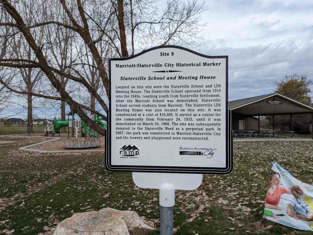
Located on this site were the Slaterville School and LDS Meeting House. The Slaterville School operated from 1910 into the 1940s, teaching youth from Slaterville Settlement. After the Marriott School was demolished, Slaterville School served students from Marriott. The Slaterville LDS Meeting House was also located on this site. It was constructed at a cost of $10,000. It served as a center for the community from February 24, 1915, until it was demolished on March 24, 1968. The site was subsequently donated to the Slaterville Ward as a perpetual park. In 2007, the park was transferred to Marriott-Slaterville City and the bowery and playground were reconstructed.
Marriott-Slaterville City Historical Marker historical marker #9, located at Slaterville Park at 250 North 2250 West in Marriott-Slaterville, Utah
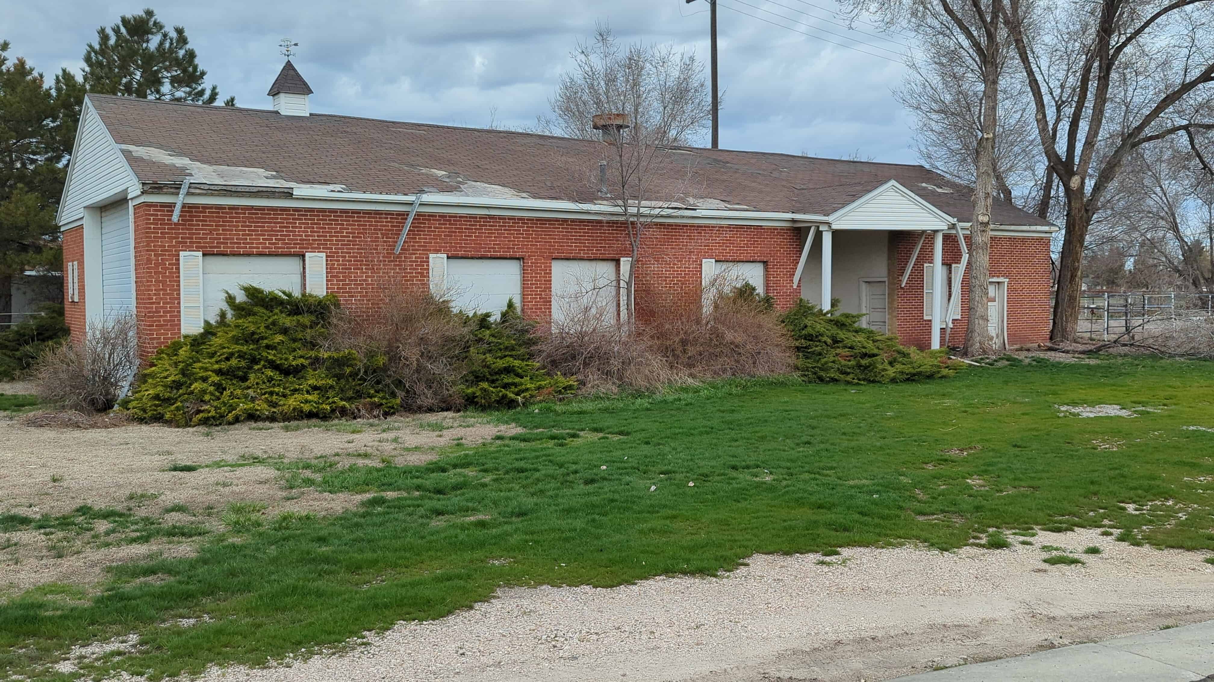
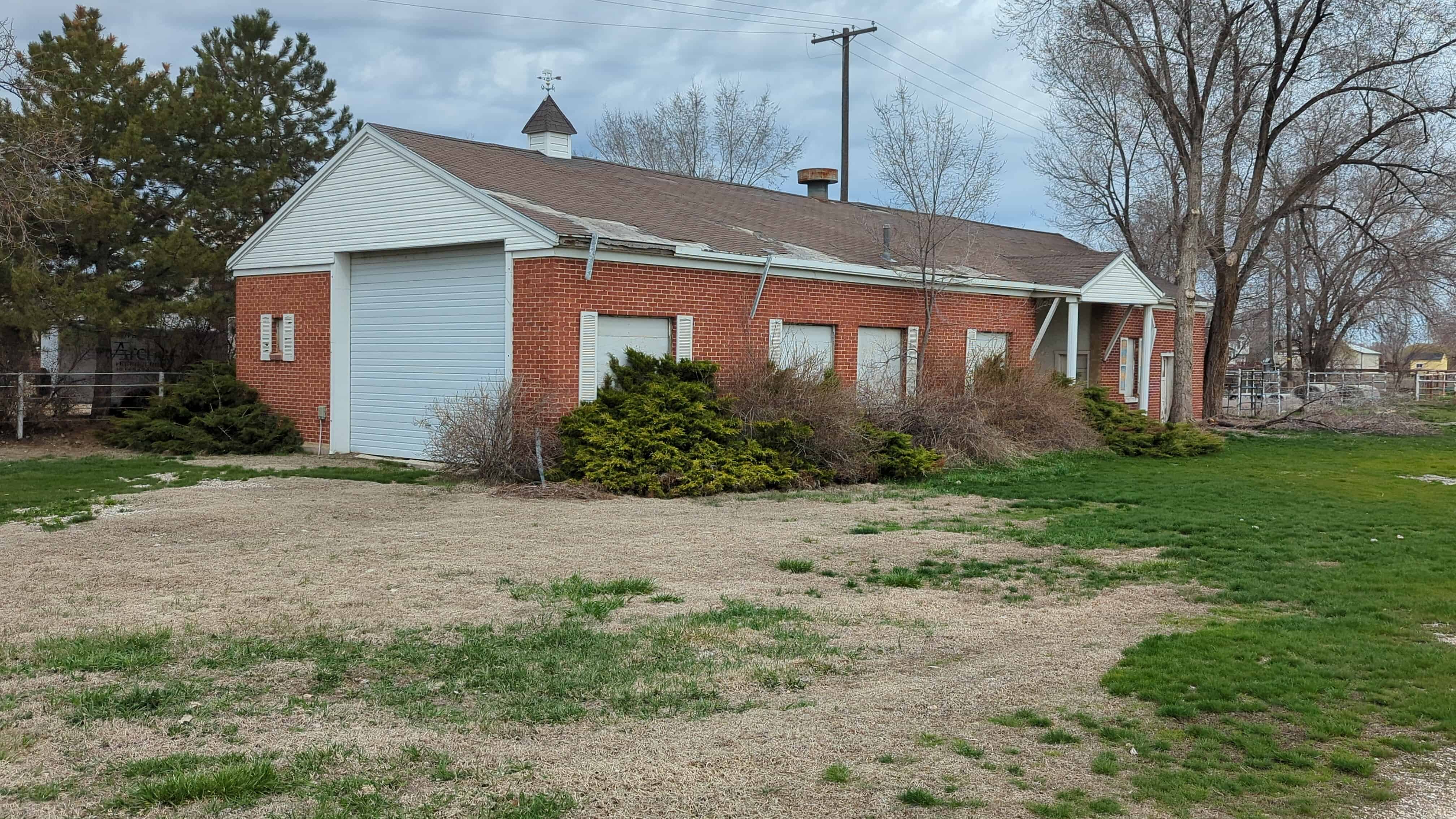
The Rose Lawn Dairy was one of the largest dairy operations in Weber County. The dairy operated throughout the 20th Century. It was initially operated by the Ekins family, and later operated by the Storrer family through the 1980s when the dairy closed. This building is the only remaining structure and served as the creamery. This creamery also made ice cream for the community. People throughout the region enjoyed the products manufactured at this site. Marriott-Slaterville City preserves this site as a historical landmark.
Marriott-Slaterville City Historical Marker historical marker #8, located at 2075 West 500 South in Marriott-Slaterville, Utah
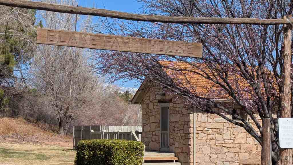
The Wallace Blake House is significant as an excellent example of the vernacular style of architecture using native materials in Utah’s Dixie. Although it was constructed in 1908, more than fifty years after the initial settlement of the area, the Wallace Blake House reflects the style and craftsmanship of houses constructed a half century earlier. In this vein the house stands as one of the last of the pioneer era and marks the transition from house construction characterized by a local style, the use of local materials and local craftsmen to one more general and universal in nature.
The Blake House is located at 965 Manzanita Road in St. George, Utah (coordinates N 37.04631 W 113.60530 )and was added to the National Historic Register on (#78002709) November 14, 1978.
The Wallace Blake house was constructed in 1908 with native stone originally used in the construction of the Price City LDS Chapel built in 1876. The house was constructed by Dode Wirthen a local stone mason who constructed many rock buildings in Utah’s Dixie. Woodwork on the house was done by Brigham Carpenter.
Wallace Blake was born January 31, 1880 at St. George, the son of Frederick and Eliza Barnett Blake. He married Isadore Larsen, a native of Bloomington on October 24, 1901. They purchased the home site and farm in June 1908 and immediately commenced construction of the house. Wallace Blake was initially a farmer and stockman by profession but later turned his attention to mining activities. In 1920 Isadore Blake died shortly after giving birth to the couple’s sixth son. The loss of his wife was a tragic event to Wallace Blake and he soon lost interest in farming or remaining in the house he had shared with his wife for twelve years. On October 31, 1921 Blake exchanged his house and property for a house in St. George owned by James S. Jones.
The Jones family lived in the house until 1928 when they sold the property and house to Albert A. McCain who remained in the house until 1937. Both James S. Jones and Albert McCain continued to farm the land. Albert McCain also helped make brooms with a nearby neighbor, Alfred Carpenter.
On December 21, 1937, Washington County took over the McCain property and held it until March 26, 1940 when D. H. Heaton redeemed it. The house was used on occasion by Heaton and his sons while they raised cattle and sheep in the area. However during the last quarter century the house has been allowed to deteriorate through neglect and lack of use. ln June 1976 the house was purchased by Mr. and Mrs. Matthew R. Simmons who plan to restore the house. The house is located in the new community of Bloomington and and serves as an important tie to the past for the residents of the modern recreation community of Bloomington.
Description:
The main structure of the Wallace Blake House is a one room, one story three bay front farm house rendered in coursed rubble limestone having one chimney of stone at the east gable end. The massing of the various sections of the structure indicate that the three bay rectangular possibly one room house was built first with a centered rear projecting bay added later to form a ‘T’ shape plan. This rear addition has a hipped roof with an off-centered stone chimney at its rear wall.
The third addition also in stone was added as a wing to the east gable end of the original structure. This addition extends back connecting with the rear bay of the house making the overall plan somewhat resemble an “L” shape. The addition was made shortly after completion of the original structure. A lean-to shed was the last apparent addition to the building, it extended along the east side of the third addition.
Entry portals are to be found on all sides of the building and its various additions. The windows flanking the original entry on the structure are the largest and were probably two-over-two sashes or possibly six-over-six. The remainder of the windows to be found in the structure are somewhat smaller and were most likely two-over-two. The third addition has two sets of windows set side by side into the front wall of the house. All window and door tops are flat supported by wood lintels. All walls are load bearing masonry with the original portion of the house showing some evidence of stucco having been applied to the exterior of the walls. An ancillary out building used &s a granary is set just to the west and has its rear wall in line with the rear wall of the second addition rear wall. This structure has a rectangular shape having a west entry. Stone used in this structure is also covered rubble and is somewhat larger than that found in the adjacent house. The roof is a gable shape having a roof slope less than that of the main house. The windows in this building are set high in the walls, set under the eaves. Their shape is basically rectangular laid out vertically. Basement windows in this structure project about two feet above the ground level with the opening supported by heavy timber lintels.
Both the main house and granary were built approximately at the same time and have walls about 18″ thick, the roofs of the buildings were composed of vertically layed flat sawed lumber with shingles covering the surface. The ridge lines of the roof were capped with one of four inch boards.
The timbers used throughout the house are from Main & Trumbull, Arizona, an important source for lumber for construction projects in Utah’s Dixie. Many of the original shingles remain on the roof. The interior walls are plastered and several rooms covered with wallpaper. Originally there was a fireplace in the living room (later closed and replaced by a stove) and stoves in each of the other three rooms.
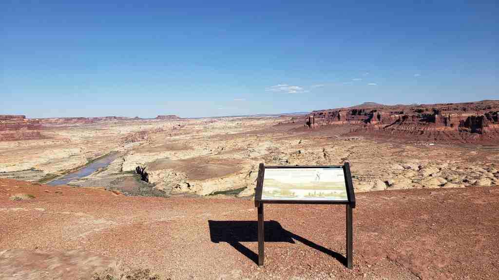
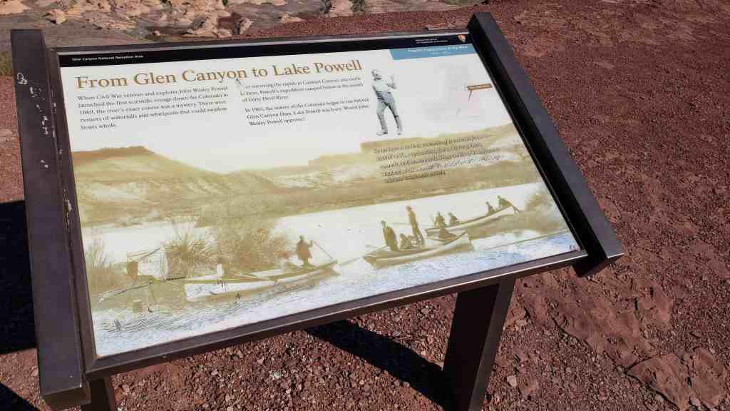
When Civil War veteran and explorer John Wesley Powell launched the first scientific voyage down the Colorado in 1869, the river’s exact course was a mystery. There were rumors of waterfalls and whirlpools that could swallow boats whole.
After surviving the rapids in Cataract Canyon, just north here, Powell’s expedition camped below at the mouth of Dirty Devil River.
In 1963, the waters of the Colorado began to rise behind Glen Canyon Dam. Lake Powell was born. Would John Wesley Powell approve?
So we have a curious ensemble of wonderful features- carved walls, royal arches, glens, alcove gulches, mounds, and monuments. From which of these features shall we select a name? We decide to call it Glen Canyon. – Major John Wesley Powell (1834-1902)
Searching For Hidden Wealth
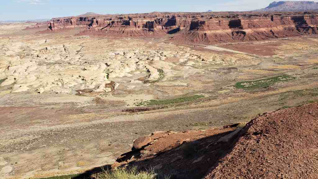
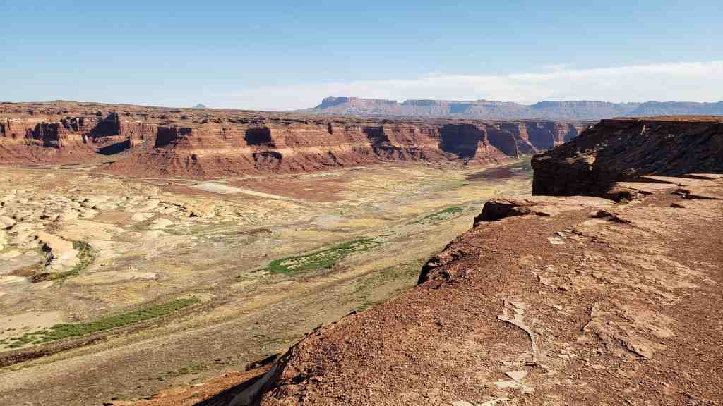
In 1883, Navajo Chief Hoskininni led Cass Hite to the canyon below. Hite found gold. He then added to his earnings by opening a small store and post office a few miles from here. Miners provided much of the business at Hite City.
After World War II, a new wave of people rushed in. The town’s population swelled to more than 200 Locals said miners had “uranium on the cranium” as they searched for “hot” rocks.
Like so many mining booms, this one eventually went bust. Hite returned to a small-town existence. In 1964, the rising waters of Lake Powell swallowed up Hite, ending forever what dreams of hidden wealth had begun. Today, the surrounding scenery remains a treasure in full view.
John Marriott, an English immigrant and pioneer, permanently settled here in 1855, founding Marriott Settlement or Marriottsville. Other families soon arrived including the Butler, Elmer, Hodson, Morris, and Stanger families. In 1856, the Marriott branch of The Church of Jesus Christ of Latter-day Saints was formed. Marriott Ward was incorporated on March 22, 1882, and a meeting house was built near this site in 1893. On September 25, 1965, the meeting house was demolished.