Hyrum Willard Marriott and Ellen Morris Marriott Farm
Hyrum Willard Marriott was the sixth son of John Marriott and Elizabeth Stewart. He married Ellen Morris, a daughter of William Morris. Together they raised a family of four boys and four girls near this site. The family farmed this ground, some of the richest farmland in Utah. The Weber River courses along the south of the farm depositing fertile sediments and carving oxbow ponds on its travels to the Great Salt Lake. This farm includes a portion of the “U” Pond, an oxbow pond, which was popular in the community for ice skating parties. In addition to farming, Hyrum was a butcher, leather worker, and sheep rancher. He served in the bishopric of the Marriott Ward for 17 years and as a member of the Utah legislature. This farm is preserved in perpetuity by Marriott-Slaterville City, and made possible, in part, by a generous donation from the J. Willard and Alice S. Marriott Foundation.
Marriott-Slaterville City Historical Marker historical marker #7, located at 2271 West 700 South in Marriott-Slaterville, Utah
This tithing granary was built about 1905 and is on the National Register of Historic Places as one of only a few well-preserved tithing buildings in Utah. The successful “in-kind” tithing system of The Church of Jesus Christ of Latter-day Saints was in place between 1850 and 1910. Tithing lots, which usually included a granary, an office, and several auxiliary structures, were facilities for collecting, storing, and distributing farm products donated as tithing by Church members in cash-poor agricultural communities throughout the state. These tithing lots were a vital part of the community, serving as the local center of trade, welfare assistance, and economic activity. Tithing lots were also important as the basic units of the Church-wide tithing network centered in Salt Lake City.
All of the buildings on the tithing lot were demolished, except the granary, in the 1950s. The Doug and Ruth Clark family later donated it to the Martin Harris Camp of Daughters of Utah Pioneers. The granary was moved to its present site in 2018 and restored. It now houses a DUP satellite museum with artifacts collected from many sources in the area that represent Clarkston’s heritage. Stone from the original foundation was used to create the marker.
This is Daughters of Utah Pioneers historic marker #592 located at 88 West Center Street in Clarkston, Utah. The marker was dedicated in 2022.
The Tithing Granary was moved on September 8, 2018 to this location at 88 West Center Street from 94 South 100 East (10212 North 8700 West), it was added to the National Historic Register (#85000250) on January 25, 1985.
Built c. 1905, the Clarkston Tithing Granary is historically significant as one of 28 well preserved tithing buildings in Utah that were part of the successful “in kind” tithing system of The Church of Jesus Christ of Latter-day Saints (LDS or Mormon church) between the 1850s and about 1910. Tithing lots, which usually included an office and several auxiliary structures, were facilities for collecting, storing, and distributing the farm products that were donated as tithing by church members in the cash-poor agricultural communities throughout the state. Tithing offices were a vital part of almost every Mormon community, serving as local centers of trade, welfare assistance, and economic activity. They were also important as the basic units of the church-wide tithing network that was centered in Salt Lake City.
The Clarkston Tithing Granary was built c. 1905, probably at about the same time as the construction of the nearby tithing office, which was demolished in the late 1950s. This part of the block was owned by the LDS church and was used as the tithing lot where all the farm products that were donated as tithing were stored. This granary is the only building or structure that remains from the tithing yard. The tithing office, which was located on the corner to the west of the granary, was demolished around 1957, the scales for weighing wagons were removed at an unknown date, and corrals and other granaries that may have been part of the tithing lot are no longer there. A frame building in the center of, the block behind this granary is reportedly the old Relief Society Granary. During the late nineteenth and early twentieth centuries, the Relief Society, the women’s organization of the LDS church, took upon themselves the responsibility for collecting and storing grain for emergency or welfare assistance. That program was separate and distinct from the tithing program, therefore that building and others like it around the state are not included in the Tithing Building Thematic Resources nomination.
The design of the Clarkston Tithing Granary is a specific type of granary that is found in other northern Utah communities, especially in Cache Valley, but which was possibly a standard design approved and issued by the LDS church from its headquarters in Salt Lake City. Although no direct reference to the Clarkston Tithing Granary has been found in correspondence from the Presiding Bishopric’s Office, which administered the tithing program, a letter pertaining to a granary of similar construction in Garland substantiates the assumption that this was a standard design. It included the following description:
We prefer that you follow the granary plan sent you herewith, and known as granary No. 6, built of 2×4 lumber, spiked and set on three parallel foundation walls, which we find the best style of granary for tithing purposes.”
That description, though not very detailed, fits the Clarkston Tithing Granary, as well as the Lewiston Relief Society Granary, and is very similar to the Lewiston Tithing Granary. A number of other such granaries featuring walls made of 2x4s stacked on top of each other have been identified in farmyards in Lewiston and other northern Utah communities, indicating that it was a popular type whose origin was not solely the LDS church.
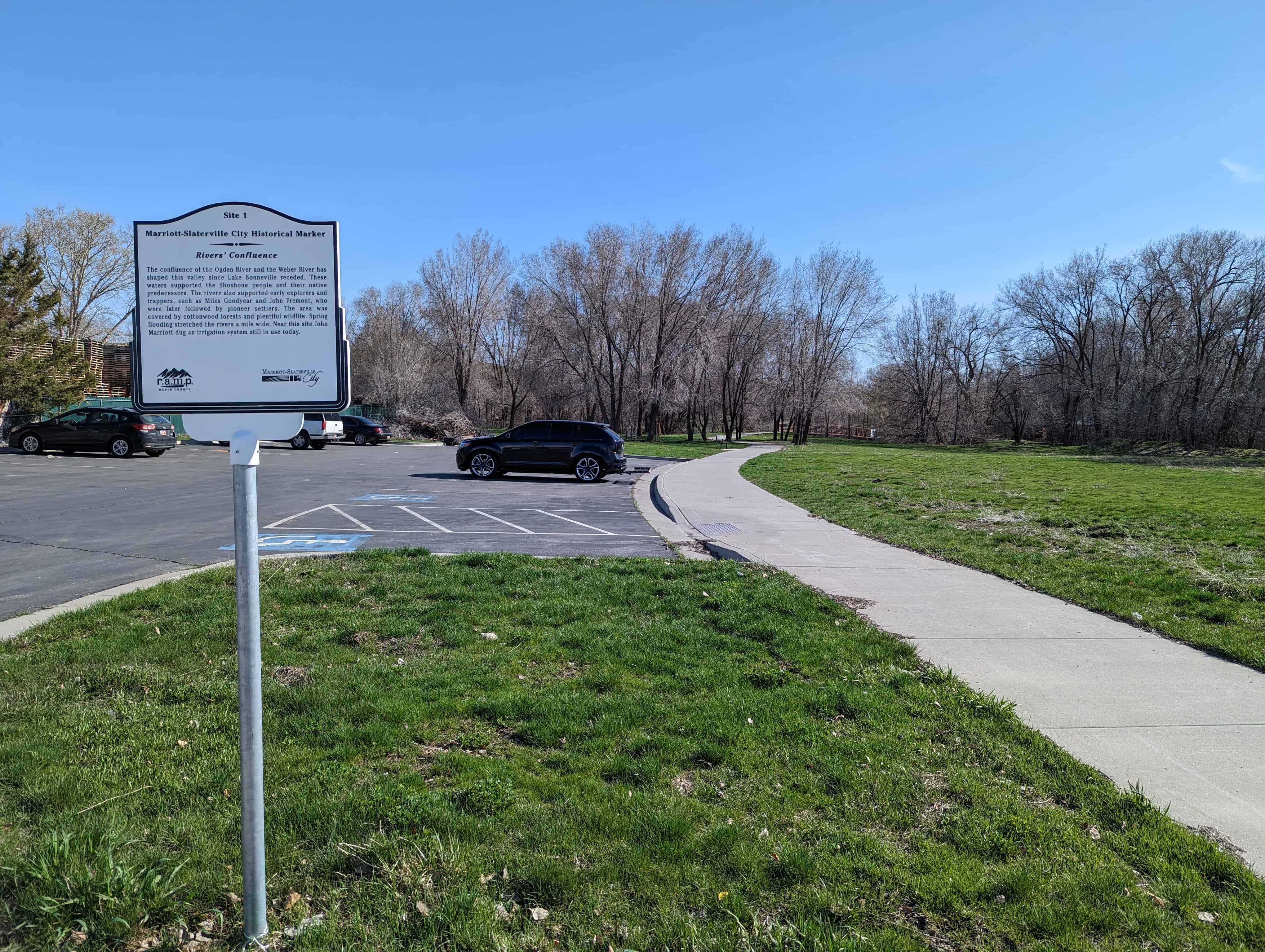
The confluence of the Ogden River and the Weber River has shaped this valley since Lake Bonneville receded. These waters supported the Shoshone people and their native predecessors. The rivers also supported early explorers and trappers, such as Miles Goodyear and John Fremont, who were later followed by pioneer settlers. The area was covered by cottonwood forests and plentiful wildlife. Spring flooding stretched the rivers a mile wide. Near this site John Marriott dug an irrigation system still in use today.
Marriott-Slaterville City Historical Marker historical marker #1, located at 903 West 1700 South (17th Street) in Marriott-Slaterville, Utah
The Redmond Town Hall is one of the best remaining examples in Utah of a building which served as a community center for religious, educational and political purposes. The original adobe structure with the larger rock addition also stands as an excellent example of the evolution of community buildings in rural pioneer Utah.
Located at 18 West Main Street in Redmond, Utah and added to the National Historic Register (#76001836) on September 13, 1976.
The community of Redmond was settled in the late summer and early fall of 1875 primarily by Scandinavians from nearby Salina. The first years were devoted to the clearing of farm land and digging of irrigation ditches and canals. In 1881 the original adobe section of the town hall was constructed. Citizens contributed both money and work in the commercial undertaking. The 24′ x 36 adobe structure was used for LDS Church services, as a school, and for town meetings. Within a short time the building proved too small to meet the various community needs and in the mid 1890’s a larger two story rock building was constructed adjacent to the original adobe building,
The two connected buildings served as Redmond’s church and school until 1911 when a school house was completed west of the town hall and 1917. when a-church was built-across the street southeast of the building.
The town hall continued to function as a community center after 1917. It is presently (1976) being renovated as a community Bicentennial project.
The Redmond Town Hall consists of an adobe structure built in 1881 and an adjoining rock structure built in the 1890’s.
The adobe building measures 24 v by 36 feet, contains one room, is one story in height and has a gabled roof. Entry was made through either of two doors flanking a single window on the east side of the building. The multi-purpose room was heated by a stove connected to the chimney still situated at the north end of the building. The adobe walls have been sheathed with scored stucco intending to imitate smooth cut stone. An unpretentious edifice, the only decorative elements were the Federal lintel caps, the corbeled brickwork on the chimney and perhaps the modestly adorned box cornice and plain frieze. The ends of two beams supporting the ceiling joists can be seen resting in the wall from the outside of the building. Metal tension rods or tie bars are also apparent on either side of a large vertical masonry crack in the north wall. After its discontinuance as a meetinghall, the adobe building served as a jail. Steel bars in a few windows remain as evidence of newer function.
Connected to the small adobe on the south is the two-story rock Town Hall, built apparently between 1891 and 1897. While the earlier building was vernacular in style and unpresuming, the newer structure took on an air of dignity and style, however, modest. The rectangular structure was built of a light colored limestone quarried east of Redmond. The stone was cut, squared, slightly rock faced, and laid in a plain ashlar pattern.
Formality of design was provided by a regular window schedule with windows on both floors being of equal size and type and being arranged directly over one another. All window and door bays are segmentally arched with stone voussoirs of the same dressing as the face stone. All windows are 2/2 double-hung sash type and have wooden sills. The roof is hipped and has a lowered belfry on the ridge which runs east and west. The chimneys are brick and corbeled and are secured to the roof by metal tie bars. The cornice is simply boxed and overhangs the building by about 20″. There is no frieze or any decorative wooden or masonry trim.
As one enters the Redmond Town Hall through its only door, a large single room is found at the right (east) while directly ahead (north) is a stairway which leads to the two upper rooms on the second floor. The main room on the ground floor was used for mass meetings and as a small library. The council room was the smaller of the two upper rooms (on the east), while the other second story room (on the west) was used for recreational functions.
The interior walls, ceilings, floors, moldings, doors, hardware, etc., are almost completely intact. The door and window mouldings are a post-Eastlake type and provide the greatest element of architectural relief.
Both parts of the Redmond Town Hall are in stable condition and are undergoing restoration as a Utah Bicentennial project.
This building was constructed in 1914 and is historically significant for its long association with the early 20th century development of Ogden City’s transportation and railroad district. The Royal Hotel originally provided housing for blue collar railroad workers and travelers. In the 1920s and 1930s, the hotel provided housing to many of the Basque workers from the Pyrenees Region of France and Spain who had come to work in the wool and sheep industry which was largely dependent on rail transportation until the early 1940s. During the 1940s, the Royal became one of very few accommodations available to African-Americans, because of segregation. The hotel also served as an office for the black military police during World War II.
The Royal was constructed during a time in which this area was becoming a center for commerce, entertainment, and lodging. Several other hotels were also constructed around this same time including the Healy Hotel and the New Brigham Hotel, both of which are on Wall Avenue, and the Marion Hotel, Windsor Hotel, and Helena Hotel which are on 25th Street.
The contractor for the Hotel was George A. Whitmeyer and Sons, a prominent local builder and contractor, who had built many of Ogden’s important public buildings, schools, libraries, office buildings, hotels and residences. The first story provided space for shops and offices while residential rooms were found on the second and third stories. The building was one of the most modest hotels in the district in terms of size and design.
A later addition to the rear of the original building was a jai alai (hie-lie) court. This structure is similar in size to the hotel and was constructed between 1920 and 1930 to provide the Basque residents a place to play their native game, which loosely resembles squash played by two teams of two people. The jai alai court was an important tie to the culture and heritage identity of these Basque immigrants.
The Hotel is a three-story brick building with a flat roof. The exterior façade is a uniform reddish brown, and a common variegated red/brown/tan colored brick for the sides and rear walls. The lower front façade features three bays matching the second and third story bays. The center door bay is recessed with historic entry doors made of wood and aluminum. Above the center door is transom of pattern glass. The upper façade features a concrete sill above the second and third floor window panels with a broad, simple detailed overhanging cornice made of metal.
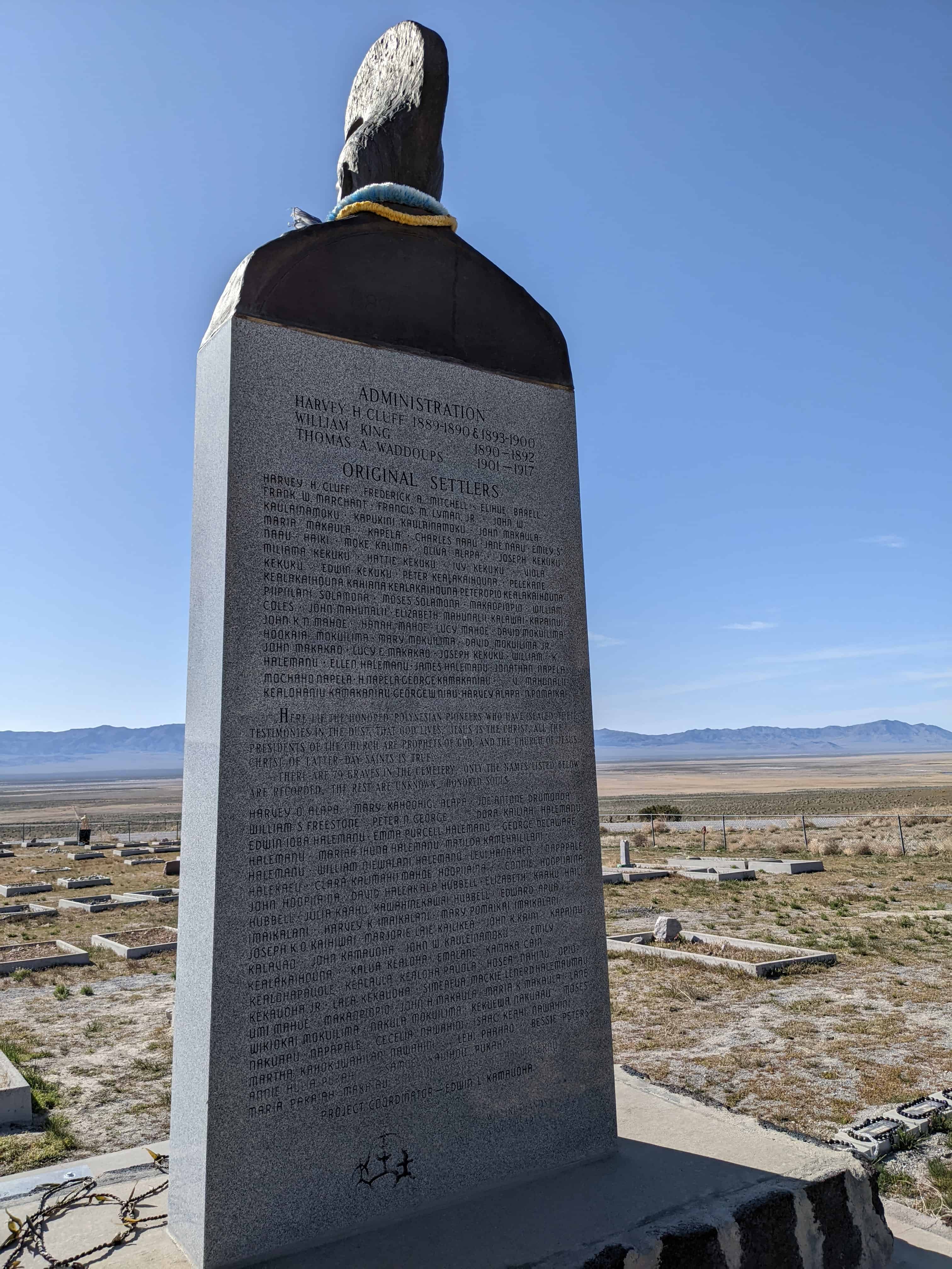
This hallowed place was dedicated on August 28, 1890 by President Wilford Woodruff for all the nations in the isles of the seas, the Polynesian pioneers, their descendants and the faithful Church leaders who left their home in the mid 1800’s and migrated to this gathering place in Zion to be married in the holy Temple for time and eternity.
For 28 years (1889–1917) Iosepa was their home. In spite of the climate, isolation, loneliness, sickness, hardship and death, their faith and courage never faltered. They overcame the cold winter, the summer heat, enjoyed the new life of spring and the bounteous harvest of the fall.
Their native songs and dances filled this beautiful valley, which they made “bloom as a rose,” with love and aloha. A few remained in Utah, some on this consecrated spot, while the rest returned home to their beloved isles of the sea.
The seeds of our Polynesian pioneers bore fruit in Hawaii—the Laie Temple, Brigham Young University – Hawaii, and the Polynesian Cultural Center. Holy Temples stand firm in New Zealand, Western Samoa, Tonga, and Tahiti as monuments to the testimonies of the faithful Polynesian pioneers. We close this memory with their song of love: Iosepa Kuu Home Aloha Iosepa My Home of Love / Iosepa Kuahiwi Ika Nani Iosepa With its Beautiful Mountains / Iosepa Ka Home No Ka’oi Iosepa My Best Home.
This lonely fire hydrant serves as a land marker for the town site of Iosepa, Utah, located on the desert floor between Cedar Mountain and the Stansbury Range in Skull Valley. Iosepa was named after Joseph F. Smith, 6th president of the L.D.S. Church. About 50 Hawaiians left Salt Lake City via Garfield by train, then by 20 wagons to Grantsville, spent the night arriving in Iosepa August 28, 1889.
The public square consisted of 169 acres, with four center streets 132 ft. wide. On four sides of the town park a row of trees were planted in the center of each street. All the other streets were 66 ft. wide and the blocks were divided into 4 lots each containing ¾ acres. All the streets had Hawaiian names. The original purchase consisted of 1,920 acres, of which 200 were under cultivation, the next two years accumulated to 5,273 acres. The water came from five streams, collected in an open ditch, put into a concrete conduit that furnished culinary water to each home. A fire hydrant and irrigation ditch went with each lot. The cemetery, about ½ acre is located a mile northeast of the settlement. Iosepa won the State prize in 1911 for the best kept town and the most progressive city in the State of Utah. Only the Hoopiiana family and J. Palikapeg Nawahine remained in Utah, the rest returned home to Hawaii to settle and help built the Laie Temple (1917–1919). Iosepa returned to dust, leaving a heritage of the faithful Polynesian Pioneers and closed the chapter in the great western American History.
The Iosepa Community developed after Polynesian converts to the Mormon faith were employed as laborers by the Iosepa Agriculture and Stock Company in 1889. After numerous hardships, including bouts with leprosy, the colony attained a degree of financial independence and its population reached 228. In 1915 when the L.D.S. Church began to build the Hawaiian Temple, the need for “gathering” subsided. The Iosepa project was allowed to end and most of the settlers and their children returned to the Islands by 1917.
Mormon Church Converts from Polynesia settled in Skull Valley in 1889-1917. Working for the Church-owned Iosepa Agriculture and Stock Company.
Their settlement located 1/2 mile to the southwest and named Iosepa (Joseph) after Joseph F. Smith, then President of the church flourished until 1917 when a Hawaiian Temple was constructed. Most of the Islanders returned to their homeland, many who succumbed to the hardships of the land are buried in this cemetery.
The Iosepa settlement in Skull Valley, Utah, represents both a unique colonization effort by the Mormon Church and in the West itself. Very early in the 1850’s the Mormon Church had sent missionaries to the Polynesian people. Joseph F. Smith served his first mission at the age of fifteen and became especially beloved to them. Later many answered the “call to gather to Zion,” and settled near Wasatch Springs in North Salt Lake City However, as they did not Integrate into the society very well, and rumors of leprosy were reported, the Mormon Church undertook to settle them as a group in Skull Valley. Under a paternalistic arrangement with the Iosepa Agriculture and Stock Company (incorporated August 7, 1889), these people were employed as laborers to do farm and ranch work. In time a community of 228 souls was developed in which the Polynesian culture flourished. Fish were raised in the springs and marshes nearby. The luau was preserved as were many of their dances and customs. The Polynesians were popular performers throughout the area.
After numerous hardships, including bouts with leprosy, the colony obtained a degree of financial independence by 1910. Their standard of living was commensurate with others living in that area. When in 1915, the L.D.S. Church began to build a temple in Hawaii, the need for “gathering” subsided. The Iosepa project was allowed to end. Most of the settlers and their children returned to the Islands by 1917. However, a few remained in the area of Iosepa and Utah. Today descendants visit the region to view “the land of their inheritance.”
The first funeral was held September 15, 1889 and the cemetery established. Many others have been buried there. Finally, in 1968 Tony Hoopiana, who had been born at Iosepa and lived nearby all his life, was buried in a northeast corner plot. This Hawaiian is home, forever.
The Iosepa Settlement Cemetery in Iosepa, Utah was added to the National Historic Register (#71000856) on August 12, 1971.
The area of Iosepa, in Skull Valley, Utah, was a large 1,920 acre ranch originally. With the settlement of the Hawaiians, a small community was established, following the “block grid” common to Mormon villages. A center block was reserved for the church, a schoolhouse and other public buildings, which were built in time. At first the water supply came from a stream and ran down the edges of the streets in ditches. Later a water system was piped through the town. One fire hydrant still remains. Most of the buildings have been removed or destroyed.
However, north of the town site sets the “Iosepa Cemetery,” a small plot enclosed with a black barbed wire fence, where several score of the colonists have been buried. Many of the graves are unmarked, others have only wooden markers, some carved, and a few stone markers reflecting their artistic qualities.
Although poorly cared for today, there is genuine interest in proper fencing and upkeep of the site from both the Bureau of Land Management personnel and the Deseret Livestock Company whose property line crosses the cemetery. Its location will permit the public to visit it, where an interpretive display can be developed.
The cemetery best preserves the story of this distinctive settlement experience by a Polynesian minority.