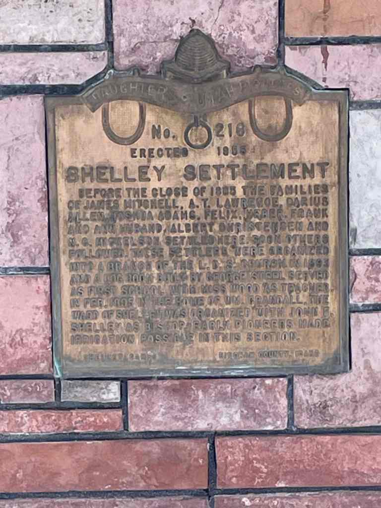
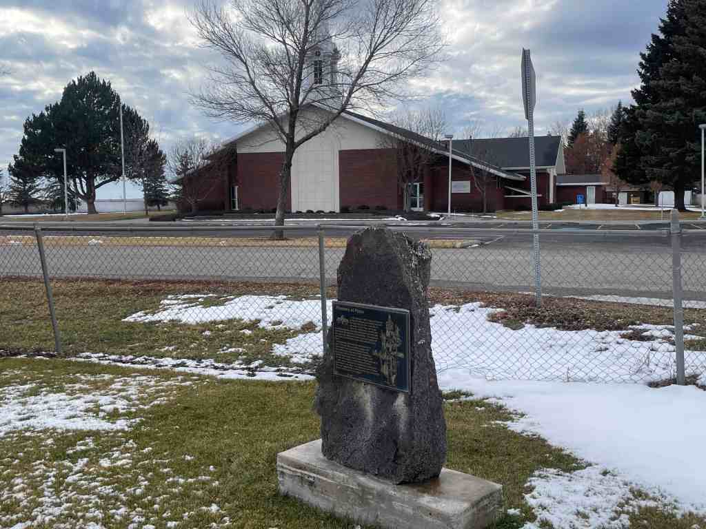
Before the close of 1885 the families of James Mitchell, A.T. Lawrence, Darius Allen, Joshua Adams, Felix, Heber, Frank and Ann Husband, Albert Christiansen and N.G. Mickelson settled here. Soon other followed. These settlers were organized into a branch of the L.D.S. church in 1893 and a log room built by George Steel served as the first school with Miss Wood as teacher. In Feb. 1895 in the home of Wm. Crandall, the Ward of Shelley was organized with John F. Shelley as bishop. Early pioneers made irrigation possible in this sector.
The above text is from the monument (Daughters of Utah Pioneers historic marker #216) located at 219 South Milton Avenue in Shelley, Idaho.
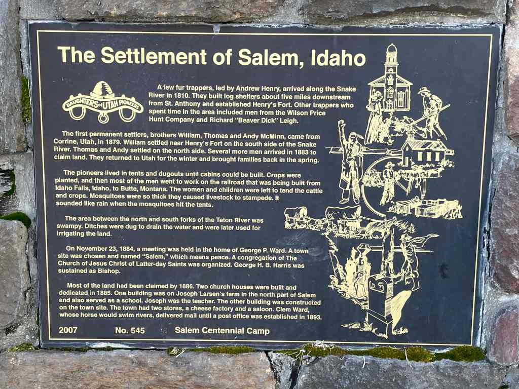
A few fur trappers, led by Andrew Henry, arrived along the Snake River in 1810. They built log shelters about five miles downstream from St. Anthony and established Henry’s Fort. Other trappers who spent time in the area included men from the Wilson Price Hunt Company and Richard “Beaver Dick” Leigh.
The first permanent settlers, brother William, Thomas and Andy McMinn, came from Corrine, Utah, in 1879. William settled near Henry’s Fort on the south side of the Snake River. Thomas and Andy settled on the north side. Several more men arrived in 1883 to claim land. They returned to Utah for the winter and brought families back in the spring.
The pioneers lived in tents and dugouts until cabins could be built. Crops were planted, and then most of the men went to work on the railroad that was being built from Idaho Falls, Idaho to Butte, Montana. The women and children were left to tend the cattle and crops. Mosquitoes were so thick they caused livestock to stampede. It sounded like rain when the mosquitoes hit the tents.
The area between the north and south forks of the Teton River was swampy. Ditches were dug to drain the water and were later used for irrigating the land.
On November 23, 1884, a meeting was held in the home of George P. Ward. A town site was chosen and named “Salem,” which means peace. A congregation of The Church of Jesus Christ of Latter-day Saints was organized. George H.B. Harris was sustained as Bishop.
Most of the land had been claimed by 1886. Two church houses were built and dedicated in 1885. One building was on Joseph Larsen’s farm in the north part of Salem and also served as a school. Joseph was the teacher. The other building was constructed on the town site. The town had two stores, a cheese factory and a saloon. Clem Ward, whose horse would swim rivers, delivered mail until a post office was established in 1893.
The above text is from the monument (Daughters of Utah Pioneers historic marker #545) located at3462 North Salem Road in Rexburg, Idaho.
In August 1903, Mark Austin negotiated the purchase of a section of land here, the south half to be used as this town site and the north half, about 1/2 mile northeast, to be used for a sugar beet factory for the Fremont County Sugar Company. By October 1903, E.H. Dyer had contracted to build the $750,000 factor. Early in 1904, the company signed an additional contract with Dyer providing for the erection of an auxiliary plant at Parker, bringing the total to nearly $1 million.
On December 8, 1903, President Joseph F. Smith, elected president of the company, laid the cornerstone of the factory which processed 35,000 tons of beets the next fall. The Church of Jesus Christ of Latter-day Saints sent 3 chemists from Germany to teach the people how to make sugar. Growing beets required very hard labor. Planting, cultivating, and digging were done with horses, but the difficult thinning, weeding, irrigating, toping, and loading were done by hand by the farmer and his family. In 1906 the company paid laborers and growers $3/4 million. The town grew and 20 businesses flourished here.
At the slicer in Parker, beet juice was extracted and pumped almost 6 miles away through a pipeline to the factory in Sugar City. The slicer was closed in 1913 because of difficulties incident to the extremely cold weather. Juice would freeze in the pipeline, and the water and beets would freeze in the flume.
Because of limitations of acreage and labor, the factory was closed in 1940 and 1941 but reopened for the last campaign in 1942. The factory was dismantled in 1947.
The above text is from the monument (Daughters of Utah Pioneers historic marker #525) located at Park Avenue and Center Street in Sugar City, Idaho.
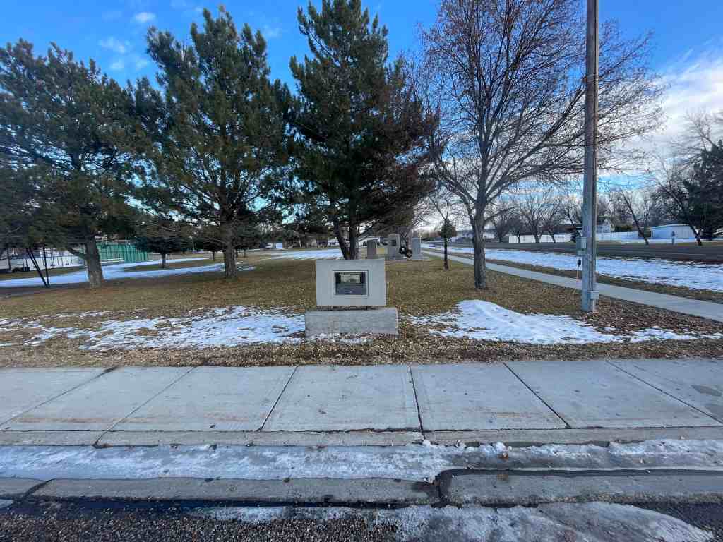
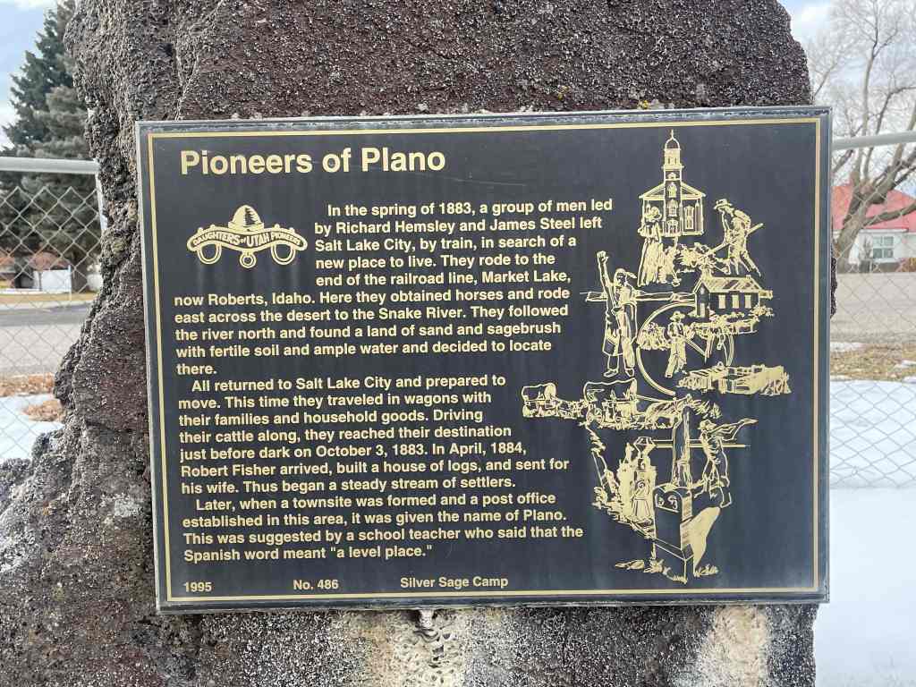
In the spring of 1883, a group of men led by Richard Hemsley and James Steel left Salt Lake City, by train, in search of a new place to live. They rode to the end of the railroad line, Market Lake, now Roberts, Idaho. Here they obtained horses and rode east across the desert to the Snake River. They followed the river north and found a land of sand and sagebrush with fertile soil and ample water and decided to locate there.
All returned to Salt Lake City and prepared to move. This time they traveled in wagons with their families and household goods. Driving their cattle along, they reached their destination just before dark on October 3, 1883. In April, 1884, Robert Fisher arrived, built a house of logs, and sent for his wife. Thus began a steady stream of settlers.
Later, when a townsite was formed and a post office established in this area, it was given the name of Plano. This was suggested by a school teacher who said that the Spanish word meant “a level place.”
The above text is from the monument (Daughters of Utah Pioneers historic marker #486) located at 5980 North 5000 West in Rexburg, Idaho.
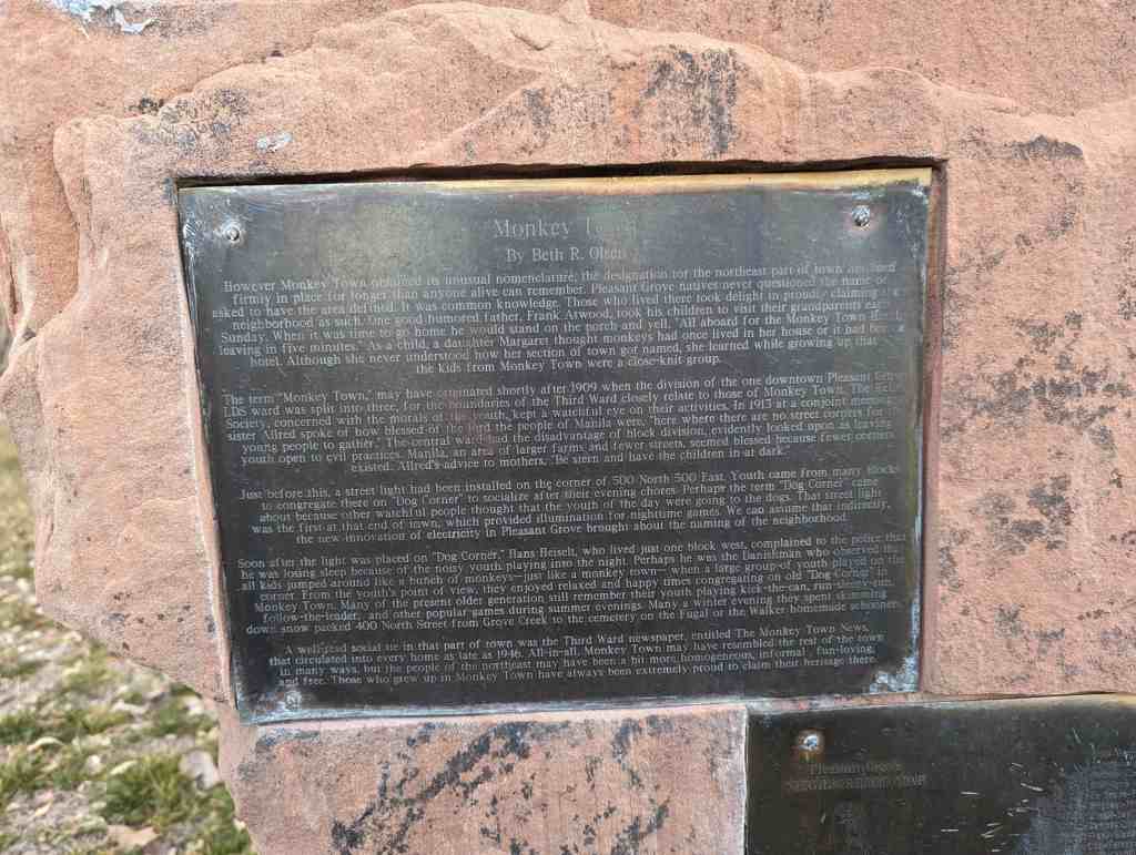
However Monkey Town obtained its unusual nomenclature, the designation for the northeast part of town has been firmly in place for longer than anyone alive can remember. Pleasant Grove natives never questioned the name or asked to have the area defined. It was common knowledge. Those who lived there took delight in proudly claiming the neighborhood as such. One good humored father, Frank Atwood, took his children to visit their grandparents each Sunday. When it was time to go home he would stand on the porch and yell, “All aboard for the Monkey Town Hotel, leaving in five minutes.” As a child, a daughter Margaret thought monkeys had once lived in her house or it had been a hotel. Although she never understood how her section of town got named, she learned while growing up that the kids from Monkey Town were a close-knit group.
The term “Monkey Town,” may have originated shortly after 1909 when the division of the one downtown Pleasant Grove LDS ward was split into three, for the boundaries of the Third Ward closely relate to those of Monkey Town. The Relief Society, concerned with the morals of the youth, kept a watchful eye on their activities. In 1913 at a conjoint meeting, a sister Allred spoke of how blessed of the lord the people of Manila were, “here where there are no street corners for the young people to gather.” The central ward had the disadvantage of block division, evidently looked upon as leaving youth open to evil practices. Manila, an area of larger farms and fewer streets, seemed blessed because fewer corners existed. Allred’s advice to mothers, “Be stern and have the children in at dark.”
Just before this, a street light had been installed on the corner of 500 North 500 East. Youth came from many blocks to congregate there on “Dog Corner” to socialize after their evening chores. Perhaps the term “Dog Corner” came about because other watchful people thought that the youth of the day were going to the dogs. That street light was the first at that end of town, which provided illumination for nighttime games. We can assume that indirectly. the new innovation of electricity in Pleasant Grove brought about the naming of the neighborhood.
Soon after the light was placed on “Dog Corner,” Hans Heiselt, who lived just one block west, complained to the police that he was losing sleep because of the noisy youth playing into the night. Perhaps he was the Danishman who observed that all kids jumped around like a bunch of monkeys–just like a monkey town– when a large group of youth played on the corner. From the youth’s point of view, they enjoyed relaxed and happy times congregating on old “Dog Corner” in Monkey Town. Many of the present older generation still remember their youth playing kick-the-can, run-sleepy-run, follow-the-leader, and other popular games during summer evenings. Many a winter evening they spent skimming down snow packed 400 North Street from Grove Creek to the cemetery on the Fugal or the Walker homemade schooners.
A well read social tie in that part of town was the Third Ward newspaper, entitled The Monkey Town News, that circulated into every home as late as 1946. All-in-all, Monkey Town may have resembled the rest of the town in many ways, but the people of the northeast may have been a bit more homogeneous, informal, fun-loving, and free. Those who grew up in Monkey Town have always been extremely proud to claim their heritage there.
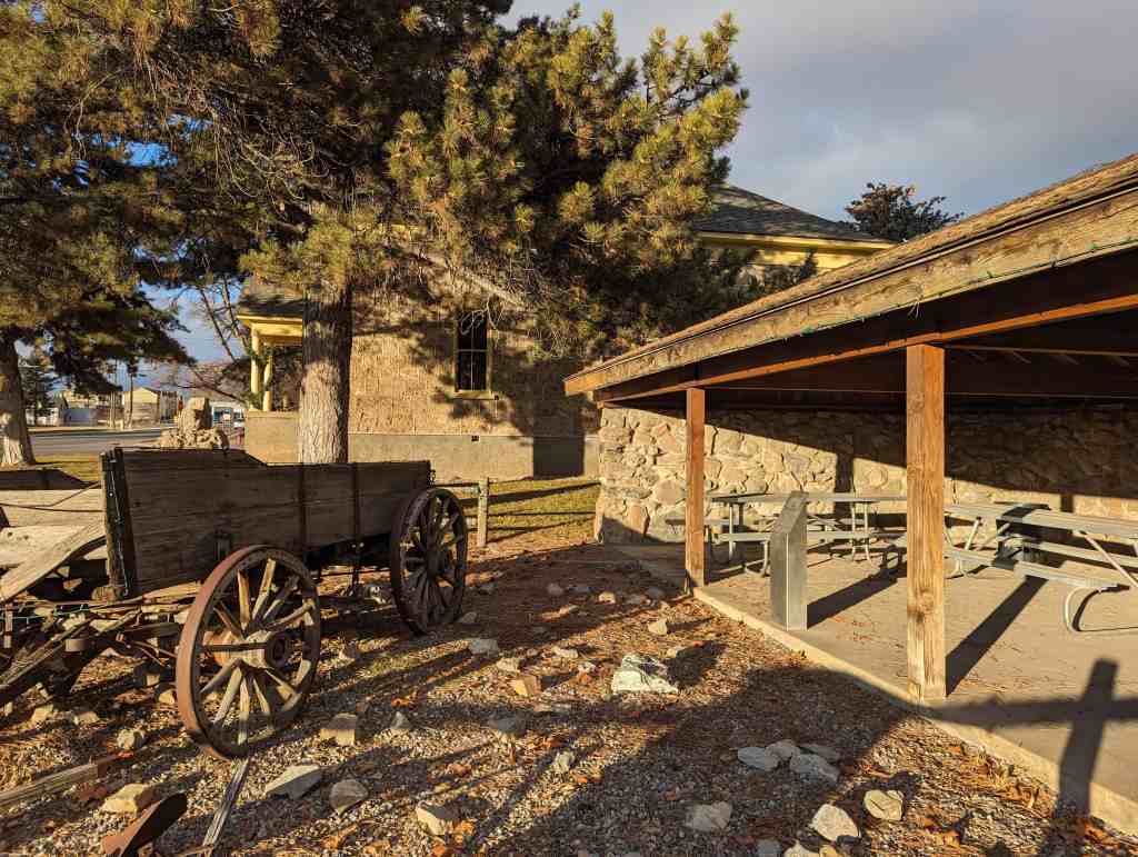
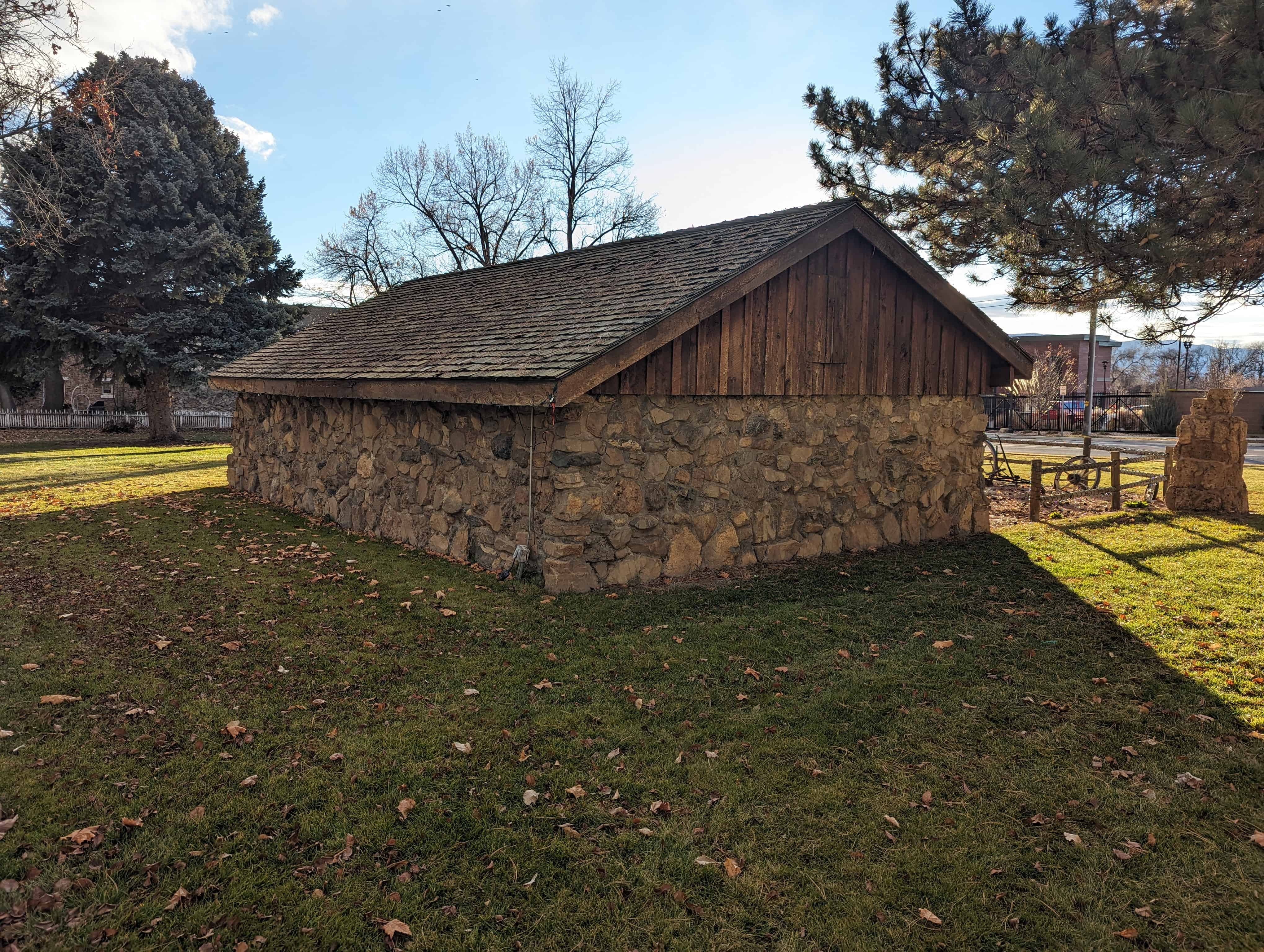
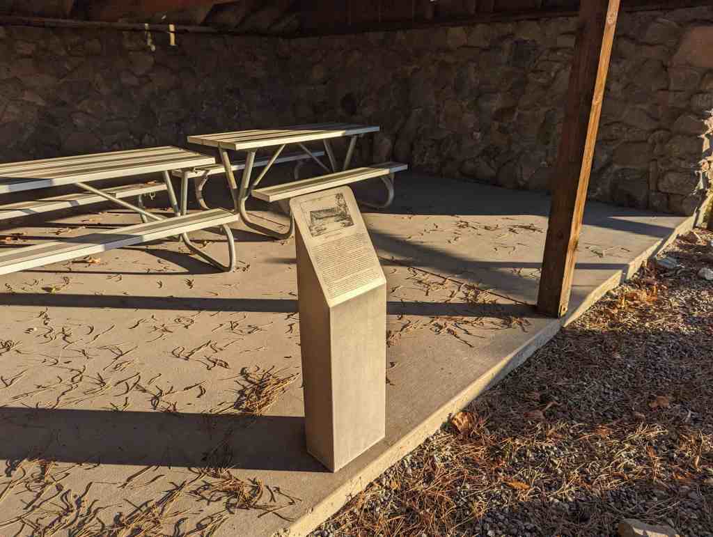
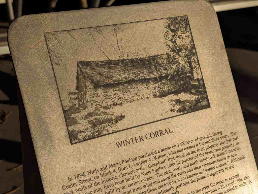
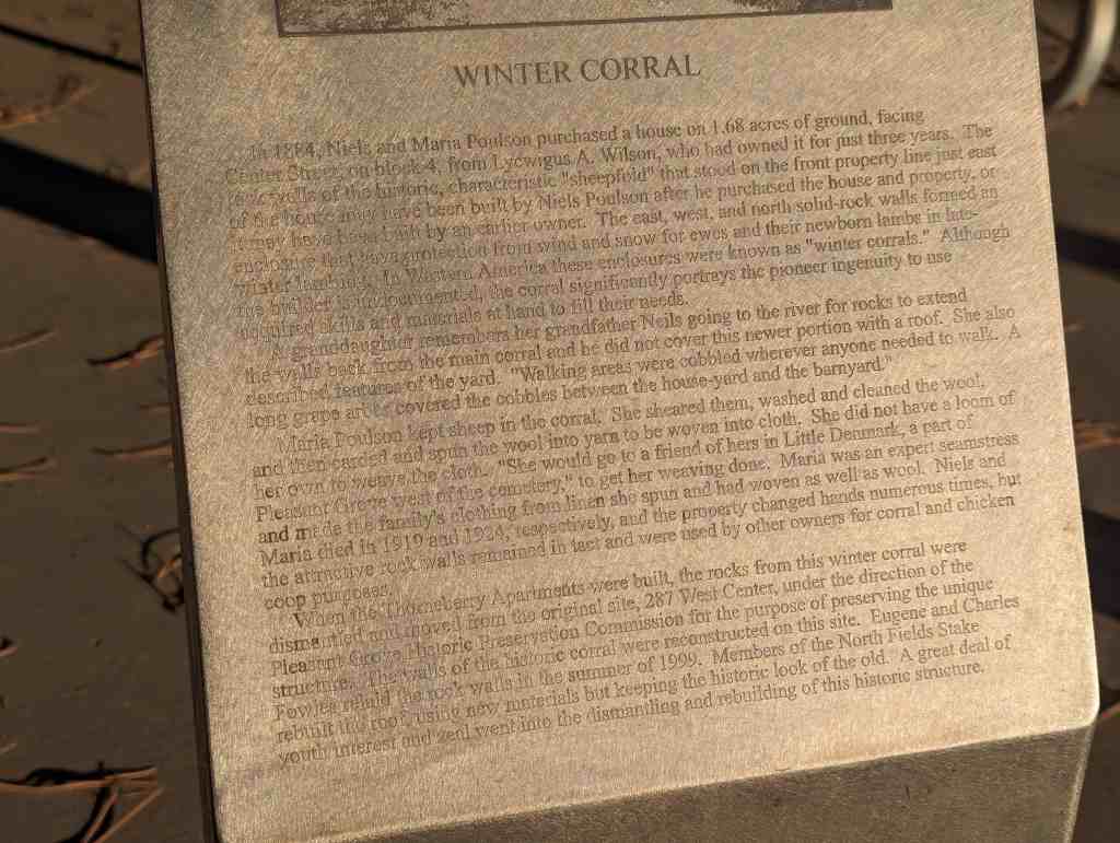
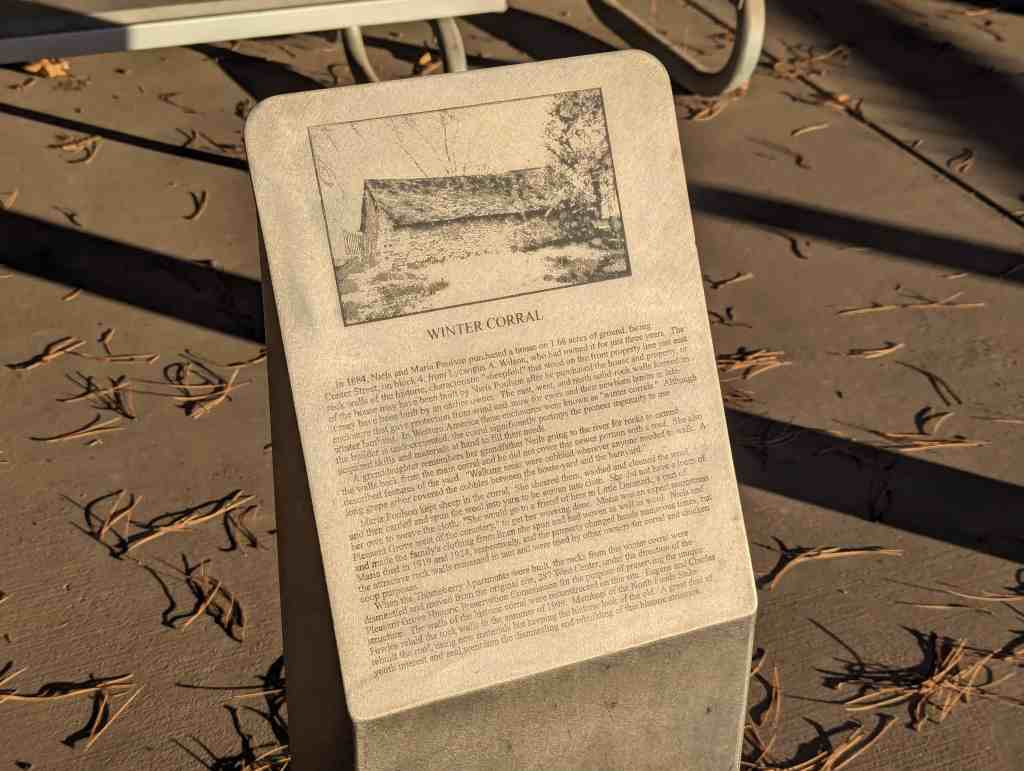
In 1884, Niels and Maria Poulson purchased a house on 1.68 acres of ground, facing Center Street, on block 4, from Lycwigus A. Wilson, who had owned it for just three years. The rock walls of the historic, characteristic “sheepfold” that stood on the front property line just east of the house may have been built by Niels Poulson after he purchased the house and property, or it may have been built by an earlier owner. The east, west, and north solid-rock walls formed an enclosure that gave protection from wind and snow for ewes and their newborn lambs in late- Winter lambing. In Western America these enclosures were known as “winter corrals.” Although the builder is undocumented, the corral significantly portrays the pioneer ingenuity to use acquired skills and materials at hand to fill their needs.
A granddaughter remembers her grandfather Neils going to the river for rocks to extend the walls back from the main corral and he did not cover this newer portion with a roof. She also described features of the yard. “Walking areas were cobbled wherever anyone needed to walk. A long grape arbor covered the cobbles between the house-yard and the barnyard.”
Maria Poulson kept sheep in the corral. She sheared them, washed and cleaned the wool, and then carded and spun the wool into yarn to be woven into cloth. She did not have a loom of her own to weave the cloth. “She would go to a friend of hers in Little Denmark, a part of Pleasant Grove west of the cemetery,” to get her weaving done. Maria was an expert seamstress and made the family’s clothing from linen she spun and had woven as well as wool. Niels and Maria died in 1919 and 1924, respectively, and the property changed hands numerous times, but the attractive rock walls remained in tact and were used by other owners for corral and chicken coop purposes.
When the Thorneberry Apartments were built, the rocks from this winter corral were dismantled and moved from the original site, 287 West Center, under the direction of the Pleasant Grove Historic Preservation Commission for the purpose of preserving the unique structure. The walls of the historic corral were reconstructed on this site. Eugene and Charles Fowles relaid the rock walls in the summer of 1999. Members of the North Fields Stake rebuilt the roof, using new materials but keeping the historic look of the old. A great deal of youth interest and zeal went into the dismantling and rebuilding of this historic structure.
The pioneers who settled Pleasant Grove found a unique type of building rock northeast of the town. The rock was a soft, porous limestone formed when minerals in water accumulate around vegetation. The pioneers called it “Soft-Rock” because when in the ground, they could easily cut it into blocks with a saw or axe. Soft-Rock had excellent insulating qualities to keep structures warm in the winter and cool in the summer. Geologists call the rock “Tufa”. Between 1865 and 1900 over 100 buildings were erected using Soft-Rock including the first Town Hall, next to the monument and the Ashton/Driggs house south of this site. In 2021, only 19 Soft-Rock buildings remain with the original rock walls visible. Many other Soft-Rock buildings are hidden under stucco or siding. The Soft-Rock on top of this monument is a remnant of the K.V. and Gwen Adams House pictured (built in 1880 and demolished in 2012). The visible notch was cut with an axe to support a window. Historical information about the Pleasant Grove Soft-Rock Buildings is available from the Pleasant Grove Historic Preservation Commission.
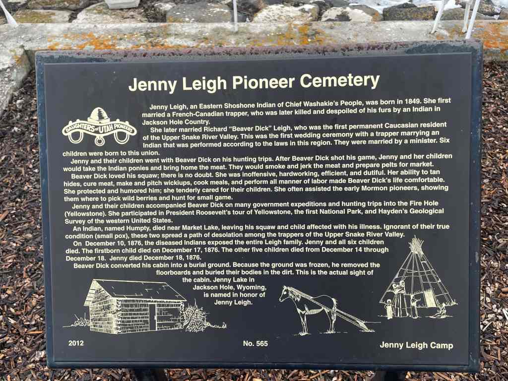
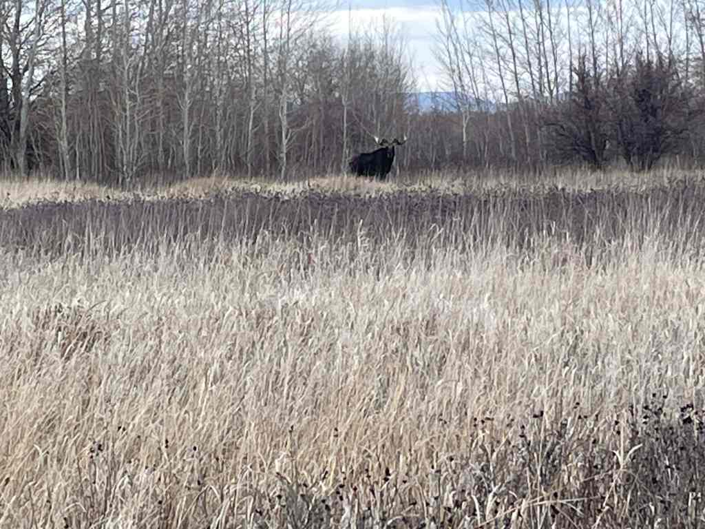
Jenny Leigh, an Eastern Shoshone Indian of Chief Washakie’s People, was born in 1849. She first married a French-Canadian trapper, who was later killed and despoiled of his furs by an Indian in Jackson Hole Country.
She later married Richard “Beaver Dick” Leigh, who was the first permanent Caucasian resident of Upper Snake River Valley. This was the first wedding ceremony with a trapper marrying an Indian that was performed according to the laws in this region. They were married by a minister. Six children were born to this union.
Jenny and their children went with Beaver Dick on his hunting trips, After Beaver Dick shot his game, Jenny and her children would take the Indian ponies and bring home the meat. She was inoffensive, hardworking, efficient, and dutiful. Her ability to tan hides, cure meat, make and pitch wickiups, cook meals, and perform all manner of labor make Beaver Dick’s life comfortable. She protected and humored him; she tenderly care for their children. She often assisted the early Mormon pioneers, showing them where to pick wild berries and hunt for small game.
Jenny and their children accompanied Beaver Dick on many government expeditions and hunting trips into the Fire Hole (Yellowstone). She participated in President Roosevelt’s tour of Yellowstone, the first National Park, and Hayden’s Geological Survey of the western United States.
An Indian, named Humpty, died near Market Lake, leaving his squaw and child affected with his illness. Ignorant of their true condition (small pox), these two spread a path of desolation among the trappers of the Upper Snake River Valley.
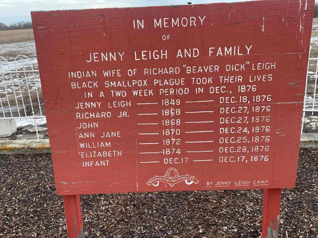
On December 10, 1876, the diseased Indians exposed the entire Leigh family. Jenny and all six children died, The firstborn (sic, newborn?) child died on December 17, 1876. The other five children from December 14 through December 18, 1876.
Beaver Dick converted his cabin into a burial ground. Because the ground was frozen, he removed the floorboards and buried their bodies in the dirt. This is the actual site of the cabin. Jenny Lake in Jackson Hole, Wyoming is named in honor of Jenny Leigh.
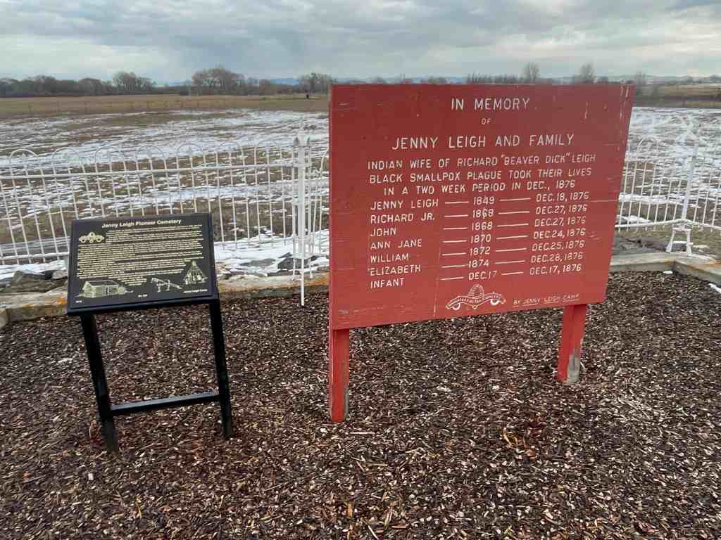
The above text is from Daughters of Utah Pioneers historic marker #565 located at the Jenny Leigh Pioneer Cemetery north of approximately 5500 West Highway 33 in Rexburg, Idaho.
The photos below were submitted by Marshall Hurst:
James Lynn Bevan March 10, 1931 – June 14, 2016 Blessed, Honored Pioneer!
“It is good to look to the past to gain appreciation for the present and perspective for the future. It is good to look upon the virtues of those who have gone before, to gain strength for whatever lies ahead. It is good to reflect upon the work of those who labored so hard and gained so little in this world, but out of whose dreams and early plans, so well nurtured, has come a great harvest of which we are the beneficiaries. Their tremendous example can become a compelling motivation for us all, for each of us is a pioneer in his own life…” -Gordon B. Hinckley, 1984
These words are now found on a plaque at the entrance of the Pioneer Museum, the place that Jim Bevan loved so much. Jim loved these words because they epitomized his own thoughts and feelings. He had a drive and desire to help everyone visualize and understand the struggles and sacrifices that were made by those men and women that lived in the very early days of Tooele.
Jim was a descendent of the faithful pioneers that established the city of Tooele. He was the 10th of eleven children born to Eli Edson Bevan and Sarah Shields Bevan. He was named after his relative James Bevan who was born in 1821 in Herefordshire, England and came to Utah in 1847 after coming from California, as a member of the Mormon Battalion. Jim’s father, they called him Kelly, was an engineer of the train that used to travel Vine Street every day giving the men a ride to and from the Tooele Smelter. Jim’s mother died when he was only twelve years old. Jim worked at the lumber company in Tooele, at the Tooele Ordinance Depot and finally at Utah Power and Light Company. He served the LDS church as a bishop, a high counselor and stake president.
Over the years Jim spent thousands of hours with his friends Russ Hammond and John Bryan and gave much in the way of personal resources in an effort to establish a place where people could visit to catch a glimpse of the past. His desire to share his love of those early pioneers and their struggles resulted in many of the displays at the Pioneer Museum. The museum now stands as a monument to his life.
This park, located at 170 South Main Street in Monticello, Utah has many pioneer relics and plaques describing them and the local history.
A Tribute to Dorothy Rasmussen Adams Born 1910 – Died 1998
Dorothy Rasmussen loved the people, culture, and history of Monticello, Utah. She arrived in her adopted hometown of Monticello in 1915 with her family. Following her graduation from high school, she entered the University of Utah and graduated in 1935 with a degree in education. Her first teaching position was in Sego, Utah. Later she taught second grade in Moab, Utah.
While working in Moab, Dorothy became reacquainted with Donald Adams, a childhood friend. They married in 1937 and moved to Monticello where she continued teaching elementary school. She and Donald had two children, so her teaching time was reduced. She continued to support the war effort through the American Red Cross and raised funds to aid people in Europe.
In 1944 Dorothy became Elementary Supervisor for the San Juan School District. She visited every grade school in the district. She often became stuck driving over dirt roads to reach some of the schools, but quickly learned to dig herself out of the sand. Over the years she taught at Monticello Elementary School and became chairperson of the Library Board for San Juan County and opened the elementary school library to summer readers. Dorothy and Donald were good friends with Harry and Mike Goulding and helped with legal matters for the establishment of Goulding’s Trading Post in Monument Valley.
As Monticello changed with the advent of uranium mining, Dorothy saw opportunities to help improve the quality of the town’s amenities by creating a golf course, swimming pool, offering a Community Concert Series, and getting the Utah Symphony to perform in Monticello. When community libraries became popular, Dorothy was appointed to both the county and state library Boards. Dorothy helped design the Blanding and Monticello libraries and insisted that local materials be used; so the red rock exteriors were from quarries in San Juan County.
Dorothy later spent hours researching the history of the original settlement of Monticello. With the capable modeling skills of Clio Nebeker, they created the Little Town diorama, now located in the Frontier Museum-Welcome Center, accompanied by The Little Green Book, a building-by-building history keyed to the diorama.
Dorothy’s efforts at community enhancement were supported by her family, especially Donald. Eventually she created Pioneer Park on a parcel of her land and worked with Rusty Musselman and other community members to build a replica of the first church in Monticello. Other buildings were added—including a Hispanic cabin and oven built by Pee Wee Barela; a Ute tepee and blacksmith shop donated by Dick Meyer; and an early family cabin donated by the Dean Robinson family. Pioneer Park was then donated to a private foundation and subsequently deeded to Monticello City. Dorothy Rasmussen Adams was committed to the betterment of Monticello. She enjoyed hearing about successes of former students and was heartened by the broadening of town services and attractions. She was a caring and skilled advocate for her town. She died in 1998, and this park is now cared for by Monticello City and the Monticello Rotary Club.
Welcome to Pioneer Park A Place of History
This park was created as a tribute to the rich and unique heritage of those who settled the Monticello area. As you explore the Park, you will discover some of the early history and ancestry of the community. Early settlers had to contend with Indians, gun-toting cowboys, and severe weather conditions. Pioneer Park is a reminder of the past and of those who have sacrificed and contributed in an effort to increase the bounty of today.
Please be respectful of the surroundings so that all who visit may enjoy the experience. A special thanks to Dorothy Adams for making Pioneer Park a reality.
Old Log Church Center of the Community
This log church is a replica of the first church in Monticello. The original church, built in 188 for religious worship, also became the core of community activities. It was a school, a refuge for the homeless, a place to dance, a site for public meetings, and a place to mourn the dead.
In addition, this one-room church served as the heart of history-making events. Its first church meeting found the Waltons, Jones, Adams, Butts, Hydes, Rogers and other pioneer families in attendance. Although they met on a dirt floor the first year, they were proud of their church and the community’s progress.
Historical Gathering
As part of the Pioneer Day celebration on July 24, 1891, the church served as a dance hall. Charles Walton played the fiddle and his son, Charles, played the little organ. John Rogers called out the square dance. The merriment suddenly ended as someone rushed in and announced that Tom Roach had stabbed Frank Hyde. A shot was then heard from outside the church building and Bill McCord, a Carlisle cowboy, was found dead. At that point it is reported that Tom Roach held everyone at gun point until Jane Walton stepped forward to reason with him. Another shot was heard and Jane was killed. Tom escaped and was not heard from again.
Log Cabin An Early Pioneer Home
This original log cabin is representative of the housing of the early pioneers in the area. It was first occupied by three brothers, Warren, John, and Scotty Williamson during the 1880s in Dry Valley., Utah. It is believed that the Williamson brothers built the home and homesteaded the land on which it was located. Their mother, a widow of a Civil War veteran, lived there on a very small pension.
Home Sweet Home
Carl and Kathryn T Williamson were married in 1933 and made this log cabin their first home. Carl worked for the Williamson brothers for the first few years of his marriage, earning $15 per month in cash and $15 per month from calf sales. These earnings were carefully saved to pay baby expenses. Income from their farm products paid daily expenses.
Cowboy Tack Shed Workstation of the West
The first white settlers of the region were cattlemen. Cattle were first introduced into the San Juan County-Blue Mountain area during the 1870s. Large numbers of the animals were placed on the thousands of acres of lush grasses which grew in the area. Spud Hudson, who came in 1878, dominated the cattle industry until about 1883.
Home on the Range
Monticello endured several typical “old west” conflicts between cowboys and Indians. The cowboy activities of imbibing and shoot ’em ups, were, as expected, a considerable contrast to the Mormon culture of its more settled residents. Many of these cowboys came into San Juan from Texas. They came to this remote canyon country to avoid the law. Some stayed in the county, developing their own cattle companies and other businesses. And became prominent citizens.
The chuck wagon, an invention of Texas cattleman John Goodnight, was declared an ideal device and was widely copied throughout the West. Besides grub, water, pots and pans, medicines, and other supplies, the cowboys’ bedrolls and few personal possessions were carried on the wagon.
Tepee A Ute Indian Home
Until about the year 1875, nomadic Ute and Piute Indians were the only human inhabitants of this area. The Ute Nation included most of Utah and western Colorado. The Navajo people seldom ventured north of the San Juan River to this area until 1900.
On the Move
Displacement of the Indian began with the advent of cattlemen, many of whom were Texans, followed by the arrival of Mormon settlers. A reservation was established in southern Colorado, and most of the Utes were relocated on the reservation. A few of the Piutes refused and became renegades, stealing cattle and threatening cattlemen and settlers. A number of skirmishes occurred in which both Indians and whites were killed. Most notorious of the renegades were Poke, Posey, and Tse-ne-gat. These people were part of the last Indian uprising in the United States.
On November 13, 1888, the Ute Chiefs signed a treaty selling the Colorado reservation to the Government and accepting the San Juan County reservation. The treaty, although signed by the Indians, was not approved by Congress. The Indians then returned to the reservation.
Sod Roof Cabin A Spanish-American Home
Hispanics have a very long history in the Southwest, dating back to the early 1600s. The Old Spanish Trail trade from Santa Fe, New Mexico, to California, passed through San Juan County near Monticello. There were no supply stations nor permanent settlements know in the area until the Mormon settlers arrived at Bluff in 1880 and Monticello in 1888.
Establishing a New Abode
Spanish-American sheepherders were recruited by local stockmen, some of whom were Land Grant families from New Mexico. Many of these people established their own homesteads in the area.
The earliest known permanent Spanish settlers were the family of Ramon Gonzalez in 1900. Other Spanish families migrated from New Mexico to the Monticello area in the early 1900s. Among them were the Manzanares, Gallegos, and Jaramillo families. This small, sod-roof cabin is typical of their dwellings.