In 1888 the first settlers of the Coltman Ward cleared the sage brush, dug canals and ditches, and built humble homes. At first it was a part of what was called Poverty Flat, later named Grant Ward. In 1896 Grant was divided and this, the south part, was named Coltman. Their one room building was used for church, school, recreation and community business meetings. Ebenhardt Bauer was the first Latter-day Saint presiding elder and also the first bishop.
Daughters of Utah Pioneers historic marker #182, erected in 1953 and located at 12448 N 5th E in Ucon, Idaho.
Under the Homestead Act of 1880, John Lingren acquired this land, cleared the sagebrush, raised vegetables and dairy products, started a nursery, planted hundred of fruit, evergreen, shade and ornamental trees. It became Idaho Falls’ first amusement park when in 1904-5 a picnic area, baseball diamond, dance pavilion, boating pond and swimming pool were added. In 1920 Idaho Falls purchased the park and later the old buildings were demolished, leaving only a log structure which had been used for school, church and tourist accommodations.
Daughters of Utah Pioneers historic marker #286, erected in 1963 and located at 530 West Elva Street in Idaho Falls, Idaho.
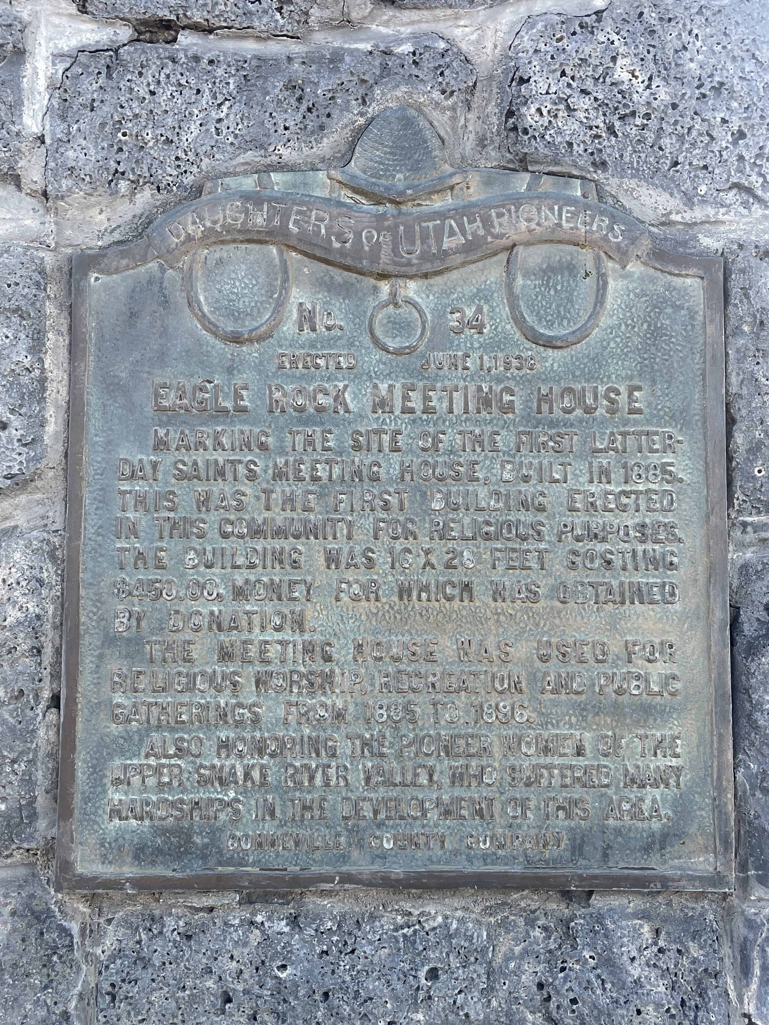
Marking the site of the first Latter-Day Saints meeting house, built in 1885. This was the first building erected in this community for religious purposes. The building was 16 X 28 feet costing $450.00, money for which was obtained by donation.
The meeting house was used for religious worship, recreation and public gatherings from 1885 to 1896.
Also honoring the pioneer women of the Upper Snake River Valley, who suffered many hardships in the development of this area.
Daughters of Utah Pioneers historic marker #39, erected June 1, 1938 and located along the Idaho Falls Greenbelt Trail near the intersection of Riverside Drive, Memorial Drive and E Street in Idaho Falls, Idaho.
The fertile soil and abundance of water in this valley lured pioneer settlers. With small slip scrapers, hand plows, picks and shovels, they cleared sagebrush, built log homes, made canals, ditches and dams to put water on the land. One of the first canals was built in 1879-1880. Rock and brush dams were built to divert water into headgates. Men lost their lives in this work. Later canals were enlarged and better dams built. The largest dam, known as the “Great Feeder”, completed June 22, 1895, diverts water from South Fork into a network of canals. Through consolidation of canal systems, 700,000 acres of irrigated land with 100 canals, known as the Upper Portion of District No.36, are using 4,150,000 acre feet of water from the river and its tributaries each irrigation season. Here the dream of reclaimed desert has been brought to full fruition. This is the legacy left by those pioneers to present and future generations.
Daughters of Utah Pioneers historic marker #228, erected in 1956 and located along the Idaho Falls Greenbelt Trail near the intersection of Riverside Drive, Memorial Drive and E Street in Idaho Falls, Idaho.
The Pass of the Standing Rock was held sacred by the ancient ones of the Shoshone and other Native American Tribes long before John C. Fremont’s exploratory party came to Weston Canyon on August 29, 1843. Fremont’s surveyors spent the entire day exploring, measuring, and illustrating this location that Fremont later named, The Pass of the Standing Rock. Illustrations of Standing Rock were published in Fremont’s The Exploring Expedition to the Rocky Mountains, depicting the Great Basin of the West.
The giant sentinel rock fell from the cliffs above, landing perpendicular near the middle of the valley. The elevation at the base of Standing Rock is 5,381 feet. The rock stands nearly 100 feet tall, is 75 feet wide, and weights several thousand tons. Nearby, naked blue limestone crags spire skyward into pinnacles that dominate ridges the entire length of Weston County.
Weston pioneer settlers arrived from Richmond, Utah, on April 15, 186?, temporarily housing their families in wagon boxes, tents and dugouts. Others dwelt in two large canyon caves. They cut logs for cabins and cedar posts for fencing. Settlers harnessed the canyon steams and springs to construct the original Pioneer Dam, located just below Castle Rock. The buffalo, elk, deer and antelope were almost extinct because of trappers who had exploited the furs of the valley. Fish and small game provided sustenance until crops could be raised. The pioneers delighted in naming the rock formations throughout the pass: Castle Rock, Vision Rock, Johnny Jump Off, Peek a Boo, Three Bars of Soap, Balancing Rock, Spirit Rock, Eagle Rock, East Gate and West Gate.
Weston is the second oldest permanent white settlement in Idaho. Bishop Peter Maughan directed construction of the first meetinghouse in 1869. Brigham Young, church president, traveled from Malad, Idaho, to Weston by coach on June 8 and 9; he delighted in the archeology of the canyon. Young’s church sermon encouraged the agricultural efforts of Weston, especially the farming of wheat.
The harsh winter snows and spring runoff often closed the pass. In 1960, the road was paved, allowing year-round access to one of the archaeological jewels of Idaho. This pass has been a place of rest, reflection, reverence, and renewal. It represents outstanding rock, flora, and forest. It is a treasured landmark in the history of the early pioneers.
The above text is from the historic marker placed by the Daughters of Utah Pioneers, see others on this page. The marker number listed on the plaque is #553 but this marker in Deseret, Utah also had that number and the DUP has called this “Pass of the Standing Rock” marker #552 in their published book.
The photos below were submitted by Marshall Hurst:
Tall sagebrush and grass, wild animals, the beautiful Tetons and surrounding mountains greeted the first pioneers of this area. Joe and Mary Weaver Baker and their eight children drove their wagon and cattle from Nebraska and arrived in May of 1889. The nearest settler was the family of Samuel Sadorus, nine miles west, who came in 1885 and called his settlement Sarilda. The Bakers settled at a spring one mile northwest of this site and called it Springville. It was later called Marysville after Mary Baker, the first postmistress, assigned on October 6, 1891. More settlers came soon after.
The Church of Jesus Christ of Latter-day Saints built a log church, in 1893, in Marysville.
By 1906 Marysville was a thriving village with many stores. In this same year, the Oregon Shortline Railroad was established which contributed to the development of Ashton. It was named after Bill Ashton, the Project Engineer.
Pioneer communities known as Lodi, Lillian, Vernon, Ora, Farnum, Warm River, Squirrel, Lamont, Greentimber and Drummond, although merged with Ashton, are still remembered by their pioneer names.
The above text is from Daughters of Utah Pioneers marker #437 erected in 1987 at 1313 North 3600 East in Ashton, Idaho.
In 1880, George Starrh, a Snake River placer miner, started a ferry across Snake River one mile north of here.
From 1880-2, freighters hauling supplies for a mining rush to Wood River used Starrh’s ferry (powered by river current when stiff winds were not blowing too hard), and local traffic lasted until Milner reservoir flooded out summer operations after 1904. But a small town with a post office (1909-12) remained there for more than a decade. During that time, nearby bridges replaced Starrh’s ferry.
This is Idaho Historic Marker #28 located near Burley, Idaho
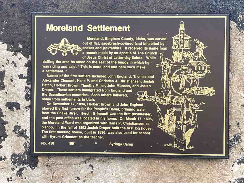
Moreland, Bingham County, Idaho, was carved out of flat, sagebrush-covered land inhabited by snakes and jackrabbits. It received its name from a remark made by an apostle of the Church of Jesus Christ of Latter-day Saints While visiting the area he stood on the seat of a buggy which he was riding and said, “This is more land and here and we’ll make a settlement.”
Names of the first settlers included John England, Thomas and Alexander Clement, Hans P. and Christian J. Christiansen, Josiah Hatch, Herbert Brown, Timothy Miller, John Munson, and Josiah Draper. These settlers immigrated from England and the Scandinavian countries. Soon others followed, some from settlements in Utah.
On November 17, 1894, Herbert Brown and John England plowed the first furor for the People’s Canal, bringing water from the Snake River. Hyrum Grimmett was the first postmaster, and the post office was located in his home. On March 17, 1896, the Moreland Ward was organized with Hans P. Christiansen as bishop. In the fall of 1893 Josiah Draper built the first log house. The first meeting house, built in 1896, was also used for school with Hyrum Gimmett as the teacher.
This is Daughters of Utah Pioneers historic marker #291 located at 880 South 5th Avenue in Pocatello, Idaho. The marker was dedicated in 1963.
A log structure was erected one half mile north of this site in 1864, which served as a stage station. The Ben Holliday stages use it as a stopping place as did the freighters who passed this way. Mail was unofficially handled here for more than a decade. On October 10, 1878 it became a United States Post Office with Theodore T. Danielson as Postmaster. It was given the name of Central Ferry and later changed to Blackfoot.
This is Daughters of Utah Pioneers historic marker #188 located at 880 West Bridge Street in Blackfoot, Idaho. The marker was dedicated in 1963.
This monument marks the route of the first Idaho railroad. The Utah & Northern narrow gauge was started as a Mormon co-op at Ogden, Utah in 1871. It reached Franklin, Idaho in 1874. Union Pacific interests extended the line to Garrison, Montana between 1878 and 1884, a total distance of 466 miles. The route through Pocatello was changed in 1883 and the gauge was standardized on July 24, 1887. The Utah & Northern brought new life to the entire area.
This is Daughters of Utah Pioneers historic marker #291 located at 880 South 5th Avenue in Pocatello, Idaho. The marker was dedicated in 1963.